

Zhangjiang River
1. Introduction
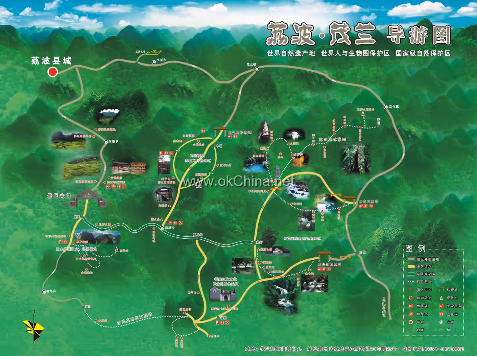
The Zhangjiang River Scenic Area, also known as the Libo Zhangjiang River Tourist Attraction and Libo Zhangjiang River Scenic and Historic Interest Area, commonly referred to as Zhangjiang Scenic Area, is a tourist attraction located within Libo County, Qiannan Buyi and Miao Autonomous Prefecture, Guizhou Province. It covers a total area of 118.8 square kilometers, with a core scenic area of 23.38 square kilometers. The Zhangjiang Scenic Area consists of the Daqikong Scenic Area, Xiaoqikong Scenic Area, Shuichun River Scenic Area, and the Zhangjiang River Scenic Belt. It features 48 representative scenic resources, including 4 top-grade, 6 first-grade, 10 second-grade, 16 third-grade, and 12 fourth-grade scenic resources. The Xiaoqikong and Daqikong Scenic Areas, named after bridges, concentrate several world-class landscapes. As important components of the Libo Zhangjiang Scenic Area, they have become significant landmarks for tourism in Libo County.
2. Geographical Environment
2.1 Location and Territory
The Zhangjiang Scenic Area is located in Libo County, Qiannan Buyi and Miao Autonomous Prefecture, Guizhou Province. It covers a total area of 118.8 square kilometers, with a core scenic area of 23.38 square kilometers. Its boundaries extend east to Gengdipo (107°57'32" E, 25°30'28" N); south to the provincial border between Guizhou Province and Guangxi Zhuang Autonomous Region (107°40'59" E, 25°11'49" N); west to Shanglaming (107°39'22" E, 25°15'49" N); and north to Shuifu Village (107°54'59" E, 25°31'42" N). The southern boundary of the Xiaoqikong Scenic Area is the provincial border between Guizhou Province and Guangxi Zhuang Autonomous Region. Its eastern boundary is the mountain ridge line near Laliu Village, which serves as the dividing line between the Xiaoqikong and Daqikong Scenic Areas. The scenic area covers 45.55 square kilometers.
2.2 Xiaoqikong Scenic Area
The eastern boundary of the Daqikong Scenic Area is the mountain ridge line near Xialeng Village, which serves as the dividing line between the Daqikong Scenic Area and the Zhangjiang River Scenic Belt. Its southern boundary is the mountain ridge line near Laliu Village, which serves as the dividing line between the Daqikong and Xiaoqikong Scenic Areas. The scenic area covers 34.17 square kilometers.
2.3 Daqikong Scenic Area
The northern boundary of the Shuichun River Scenic Area is the county border between Libo County and Sandu County. Its southern boundary is Baiyan Bridge, which serves as the dividing line between the Shuichun River Scenic Area and the Zhangjiang River Scenic Belt. The scenic area covers 20.12 square kilometers.
2.4 Shuichun River Scenic Area
The northern boundary of the Zhangjiang River Scenic Belt is Baiyan Bridge, which serves as the dividing line between the Zhangjiang River Scenic Belt and the Shuichun River Scenic Area. Its southern boundary is the mountain ridge line near Xialeng Village, which serves as the dividing line between the Zhangjiang River Scenic Belt and the Daqikong Scenic Area. The scenic area covers 14.40 square kilometers.
2.5 Climatic Characteristics
Libo County, where the Zhangjiang Scenic Area is located, belongs to the central subtropical humid monsoon climate zone. The climate is warm and humid, with distinct seasons. Winters are not severely cold, and summers are not extremely hot. Summers are long, winters are short, the frost-free period is long, rainfall is abundant, sunshine is relatively sufficient, rain and heat occur in the same season, and disastrous weather is rare. The county's annual average temperature is 18.5°C. Influenced by its relatively low geographical latitude and altitude, its heat resources are higher than those in most parts of the province, with active accumulated temperatures ranging from 4200°C to 6100°C. The frost-free period is 283 days, and the multi-year average precipitation is 1211.9 mm, with 80% of the precipitation concentrated from April to September. June has the highest precipitation, while December has the least.
2.6 Hydrological Features
The Zhangjiang River is the upper reach of the Longjiang River, a tributary of the Liujiang River, which is itself a tributary of the Xijiang River in the Pearl River system. It is the largest river within Libo County, Guizhou Province. It originates from the southern foothills of the Moon Mountain within the county, flows through 3 districts, 1 town, and 7 townships, and converges into the Dagou River at Wangmeng Street in Yaoshan Township. The main river course is 53.1 kilometers long. There are 11 rivers with catchment areas exceeding 20 square kilometers, with a total catchment area of 1498.5 square kilometers.
3. Main Scenic Areas
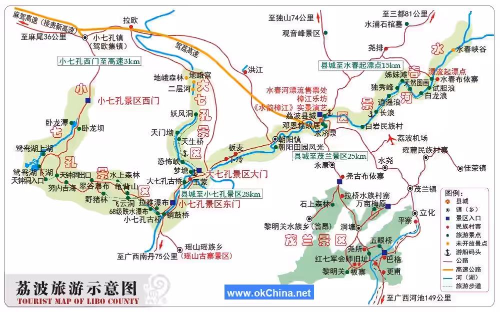
3.1 Xiaoqikong Scenic Area
3.1.1 Overview
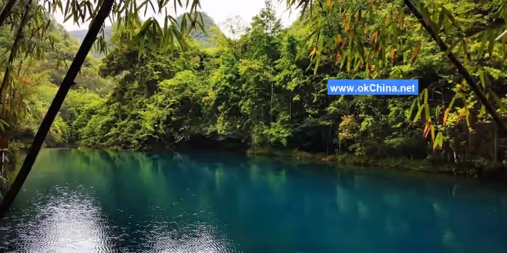
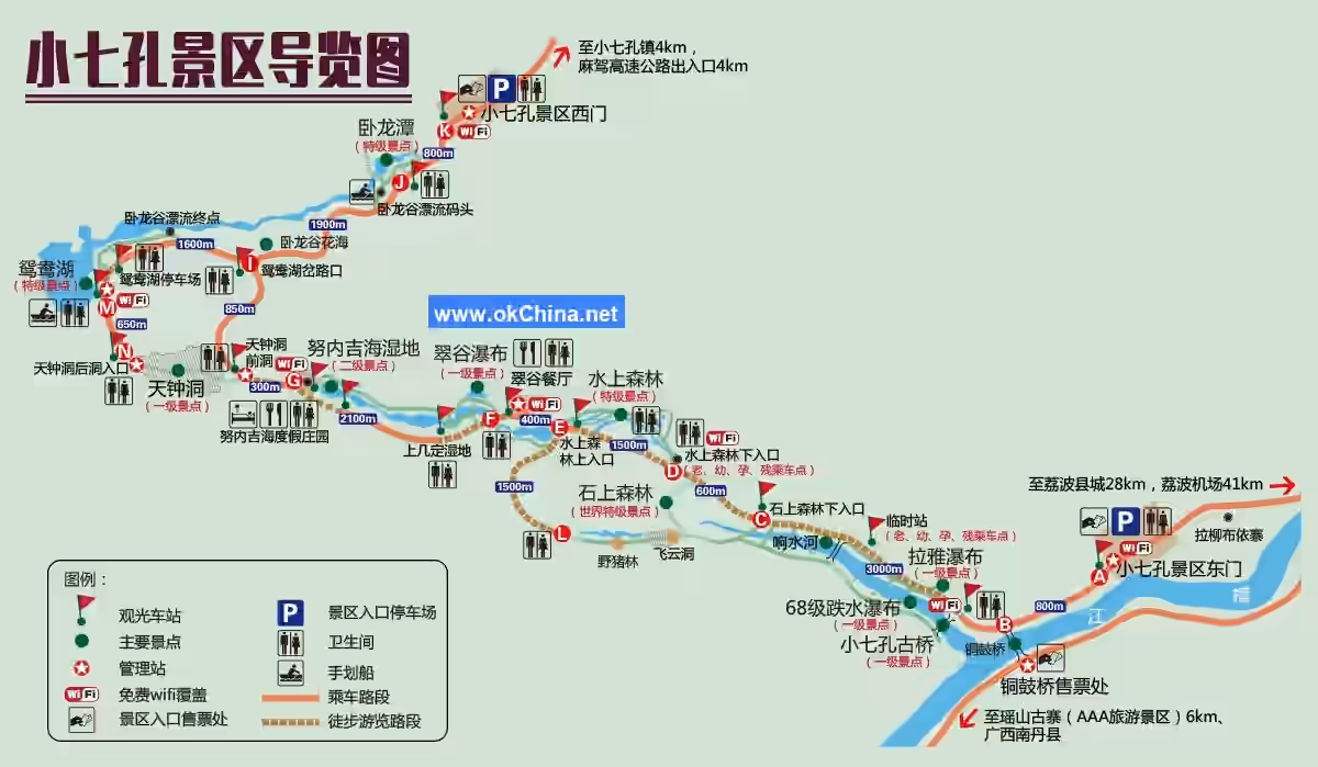
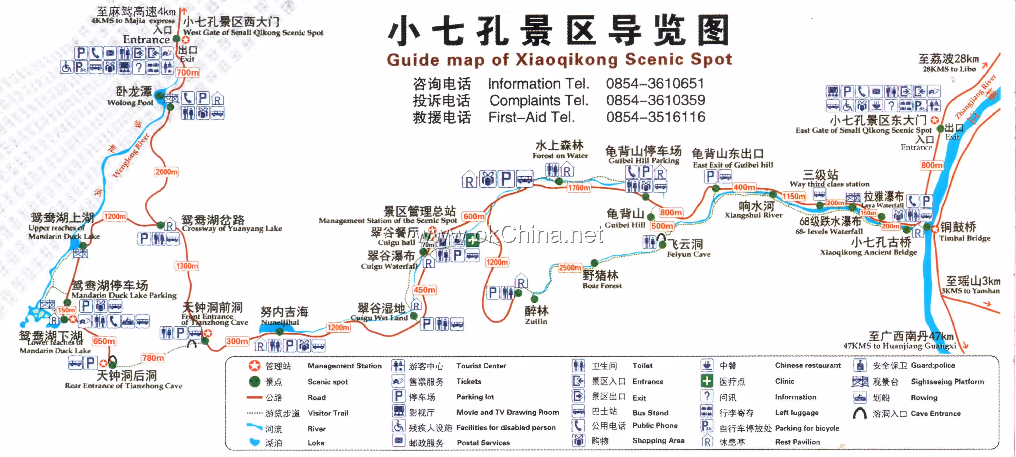
The Xiaoqikong Scenic Area is one of the four major scenic sections of the Zhangjiang Scenic Area. It is situated on the southern edge of the Guizhou Plateau, between 107°39′ E and 107°95′ E, and 25°12′ N and 25°34′ N, covering a total area of 46.4 square kilometers. The area integrates various landscapes such as forests, caves, lakes, rocks, and water, presenting exquisite beauty and earning the reputation of a "super bonsai." It is renowned for its delicacy, elegance, simplicity, and tranquility, offering ever-changing scenery that constantly refreshes the senses. It mainly features 21 scenic spots, including the Xiaoqikong Ancient Bridge, Laya Waterfall, 68-level Cascade Waterfall, Stone Forest, Wild Boar Forest, Water Forest, Tianzhong Cave, Wolong Lake, and Mandarin Duck Lake.
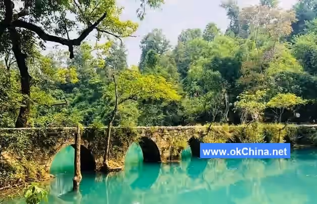
3.1.2 Xiaoqikong Ancient Bridge
The Xiaoqikong Bridge was historically a vital trade route from southern Guizhou to Guangxi, spanning the Xiangshui River. The deep blue pool beneath the bridge and the ancient lush trees on both banks accentuate the bridge's elegant and serene beauty. The bridge is 40 meters long, 2.2 meters wide, and 5.5 meters high. It features an arched structure, exquisitely designed and skillfully crafted. Originally, two stone tablets stood at the bridgehead: one was the "Bridge Construction Tablet," recording the merits of building the bridge; the other was the "Eternal Bridge Tablet," inscribed with the couplet: "The mountain rocks endure for thousands of years, the Xiangshui River bridge lasts for ten thousand years." The bridge has seven arches, commonly known as the "Xiaoqikong Ancient Bridge." The Xiaoqikong Scenic Area derives its name from this bridge.
3.1.3 Laya Waterfall
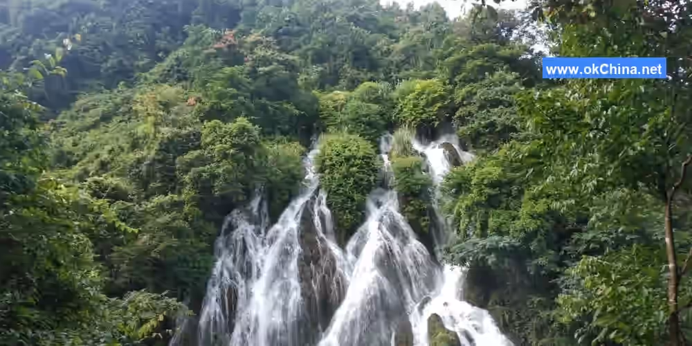
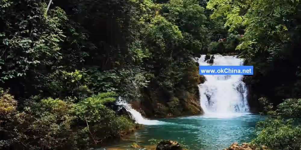
The Laya Waterfall originates from a cave spring in the upper reaches of the Xiangshui River. The intercepted flow cascades down a steep cliff face, with a drop of 30 meters and a width of over 20 meters. "Laya" translates to "beautiful goddess" in the Buyi language.
3.1.4 68-level Cascade Waterfall
The 68-level Cascade Waterfall is located in the Xiangshui River Valley, stretching 1.6 kilometers in total length with a total drop of 110 meters and a maximum width of about 40 meters. It was formed by the intense late-stage uplift of the plateau, causing the river to rapidly incise 350-500 meters, resulting in this spectacular waterfall group. Within less than 2 kilometers of winding river course, 68 levels of waterfalls and cascades with diverse forms are densely concentrated, making it a rare sight in the world.
3.1.5 Xiangshui River
The Xiangshui River is the surface flow section of the lower reaches of the Huanghou Underground River, emerging from the foot of Guibei Mountain. It is 1.6 kilometers long with a drop of 314 meters and an average flow rate of 8.03 cubic meters per second. It is called Xiangshui River (Resounding Water River) because of the numerous waterfalls on its riverbed that create thunderous sounds. The canyon is V-shaped, with cave openings distributed in layers on the valley slopes, all of which are former outlets of the early underground river. The formation is attributed to large-scale, widespread intermittent uplift in the region since the Quaternary period (approximately 2.48 million years ago). As the Zhangjiang River incised, the Xiangshui River underwent intermittent downcutting to adapt to the lowering of the erosion base level, forming multiple knickpoints on the riverbed, which are the locations of the present waterfalls. The underground rivers on the valley slopes descended to the next layer of caves to adapt to the downcutting of the Xiangshui River. Nowadays, during the rainy season, water can be seen flowing from the upper cave layers into the Xiangshui River. The water temperature remains constant throughout the year, making it a favored habitat for giant salamanders.
3.1.6 Stone Forest
The Stone Forest, located about 100 meters from the Water Forest, is a highly pristine karst forest, named after the wild Monstera deliciosa plants covering the mountains. The forest is filled with rare tree species and exotic flowers and herbs. The root systems are entirely distributed according to the rock joints, fissures, and the almost non-existent surface soil and accumulation of dead branches and leaves, creating an artistic world of intertwined roots and rocks, known as the "forest on stones."
3.1.7 Water Forest
The Water Forest is situated on the karst trough valley forest riverbed of the Xiangshui River. It is named for the phenomenon of "trees growing among rocks, water flowing over rocks." It stretches about 2000 meters in total length and includes attractions such as the Water Forest Jungle Belt, Lajin Wetland, and Kuzhu Gully. All trees in the scenic area take root in the crevices of the riverbed rocks. Despite being submerged by torrents for long periods, they remain lush and green. Such a marvelous aquatic ecosystem is unique among global karst landforms. Walking among the trees, holding onto branches and stepping through the waves, is endlessly fascinating. The dense jungle forms a screen-like barrier, and the gentle waves are warm in winter and cool in summer. Legend has it that fairies often bathed here in ancient times, hence it is also called the "Jade Pool."
3.1.8 Cuigu Waterfall
Cuigu Waterfall is located in the upper reaches of the Xiangshui River, adjacent to the Nuniji Sea Wetland. With a height of over 60 meters, it is situated in an enclosed peak cluster depression. The surrounding mountains are emerald green, and the fields are lush, hence the name Cuigu (Emerald Valley).
3.1.9 Nuniji Sea Wetland
The Nuniji Sea Wetland is located about 6000 meters from Mandarin Duck Lake, covering an area of 50 hectares. It is a typical plateau karst retention wetland. The wetland plays a crucial role in maintaining ecological balance, preserving biodiversity and rare species resources, conserving water sources, preventing soil desertification, and purifying the environment, thus hailed as the "kidney of the Earth." "Nuniji Sea" translates to "the most beautiful place" in the Yao language. The hiking tour takes about 30 minutes.
3.1.10 Mandarin Duck Lake
Mandarin Duck Lake is located about 5000 meters from Wolong Lake. It is a typical karst blind valley lake with a water area of about 20 hectares and a maximum depth of 40 meters. It is situated in the surface flow section of the lower reaches of the Huanghou Underground River and mainly consists of two large lakes, upper and lower. The negative ion content in the air is as high as 182,500 per cubic centimeter, making it an ideal environment for "lung cleansing and health nurturing." The boat tour takes about 60 minutes.
3.1.11 Tianzhong Cave
Tianzhong Cave is located on the hillside of the Tangba Stone Forest within the Xiaoqikong Scenic Area, at an altitude of over 740 meters. The cave is nearly a kilometer long with 12 halls and two entrances. Inside the cave, there is a giant stalagmite nearly 10 meters high, shaped like a heavenly bell turned upside down on the ground, standing majestically—hence the cave's name. Tianzhong Cave is a unique wonder within the Xiaoqikong "Natural Garden." It features landscapes such as stone flowers, stone trees, stone curtains, stone columns, and stalagmites. Under the illumination of lights and sound effects, they appear dazzling and vivid, making visitors feel as if they are in a fairyland.#### 3.1.12 Wolong Pond Wolong Pond is the source of the Wolong River. An underground river gushes out from the base of the cliff and cascades down a dam built for water diversion and power generation, creating a thunderous roar and a misty drizzle. The pond is surrounded by bizarre rocks and unique trees, with towering mountains tightly enclosing it, making the pond resemble an abyss from the depths of the earth, evoking the imagery of a dragon's lair or a tiger's den. During mountain floods, surging waves rush forth, truly manifesting the awe-inspiring power of a dragon.
3.1.13 Tonggu Bridge
Tonggu Bridge is located several hundred meters east of the entrance to the Xiaoqikong Scenic Area. The bridge spans 126 meters in length with a clear span of 60 meters, a width of 2.4 meters, and a height of 25 meters. Both ends of the bridge are designed in the shape of the bronze drums of the Yao people from Yaoshan. The Yao people regard bronze drums as divine gifts, treasures that protect their villages, and symbols of power. Totem poles are also erected at the bridgeheads, with relief carvings on the poles showcasing the traditional and ancient ethnic culture of the Yao people.
3.1.14 Nunenjihai Wetland
Nunenjihai Wetland is situated between Cuigu Waterfall and Tianzhong Cave. It is a secondary scenic spot and a typical plateau karst滞留 wetland. The wetland is approximately 6,000 meters from Mandarin Duck Lake and covers an area of 50 hectares. Nunenjihai Wetland plays a crucial role in maintaining ecological balance, preserving biodiversity and rare species resources, conserving water sources, preventing soil desertification, and purifying the environment. Hence, it is known as the "Kidney of the Earth." "Nunenjihai" translates from the Yao language as "the most beautiful place."
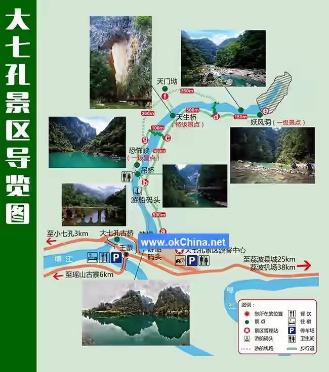
3.2 Daqikong Scenic Area
3.2.1 Overview
The Daqikong Scenic Area is one of the four major scenic sections of the Zhangjiang Scenic Area. It is located on the southern edge of the Guizhou Plateau, between 107°39′~107°95′ east longitude and 25°12′~25°34′ north latitude, with a total area of 36.2 square kilometers. The area integrates karst landforms with hydrological landscapes, featuring primitive forests, canyons, underground rivers, and subterranean lakes. The scenery is perilous, mystical, majestic, and awe-inspiring, full of thrill and mystery. Major attractions include the ancient Daqikong Bridge, Terror Gorge, Natural Bridge, Demon Wind Cave, Die Forest, Dragon Head Mountain, Two-Layer River, and Die Palace.
3.2.2 Natural Bridge
The Natural Bridge stands approximately 73 meters high, 15 meters thick, and 22 meters wide. This natural bridge, carved by the ingenious craftsmanship of nature, is hailed as the "Eastern Triumphal Arch." Viewing it inspires reverence and awe for the divine power of nature's artistry. The Natural Bridge developed within Carboniferous limestone and marl. The rock formation trends northeast-southwest with a dip angle of 56°. The river channel beneath the bridge was a late Quaternary underground river passage. Subsequent crustal uplift and downcutting by the underground river expanded the cave system, leading to the collapse of the cave roof. The Natural Bridge is the remnant of this collapsed cave ceiling.
3.2.3 Demon Wind Cave
Demon Wind Cave is a karst through-cave water tunnel. It derives its name from the eerie "demon" winds that whoosh out due to airflow vibrations caused by the waterfall at the cave entrance. The interior of the cave is pitch black, filled with tumbling rocks, some as large as houses. Several ponds, waterfalls, and lakes have formed along the river within. The cave stretches 3,200 meters in length, with a maximum width of 114 meters, a minimum width of only 1 meter, a maximum height of 90 meters, and a minimum height of 1.5 meters. The completely dark cave hosts many cave-dwelling animals, particularly an abundance of cave catfish. Formed over two million years ago, it is still actively developing.
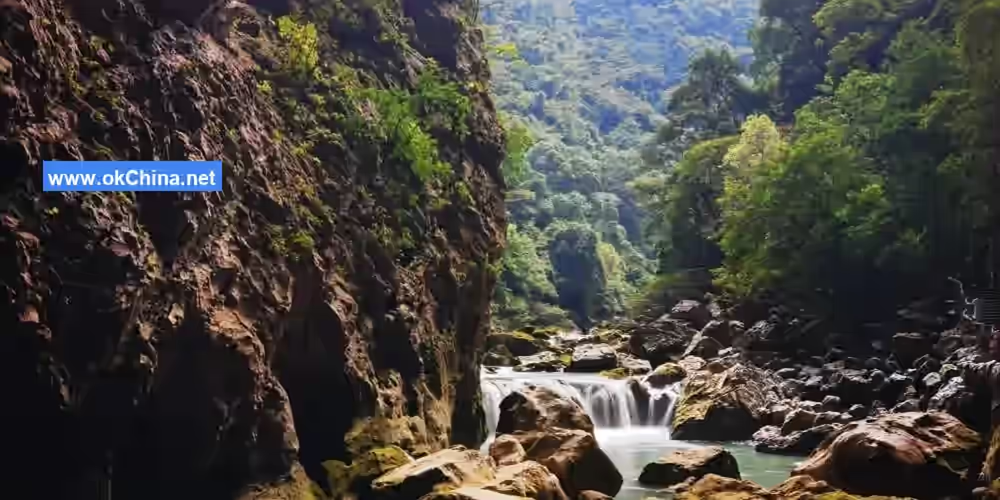
3.2.4 Terror Gorge
Terror Gorge features a deep canyon with towering cliffs and lush forests, exceptionally steep and perilous. Three deep, dark caves are embedded in the cliffs, contributing to the gorge's serene and profound atmosphere. The mountain rocks are unstable; vibrations can cause some rocks to fall. If tourists shout, resonance might coincidentally trigger flying sand and rolling stones, creating a heart-stopping experience.
3.2.5 Daqikong Bridge
The Daqikong Scenic Area is named after this bridge. The Daqikong Bridge was initially constructed in the 27th year of the Daoguang reign of the Qing Dynasty (1847) and completed in the 30th year (1850). It was originally named "Wanshan Bridge." In the 3rd year of the Guangxu reign (1877), one arch was washed away. Due to financial constraints, repairs took seven years, and it was renamed "Shuangxi Bridge." Later, it came to be known as Daqikong Bridge. In ancient times, it was a vital trade route between Guizhou and Guangxi. It is located 500 meters downstream from Mengtang in the Daqikong Scenic Area.
3.2.6 Mountain God Gorge
Precipitous cliffs on both banks of the Dagou River form a natural gorge. Traveling upstream for 1 kilometer, a cliff on the left bank, over 100 meters wide and high, soars into the clouds. Clusters of fantastical stalactites and patches of emerald forests shimmer like a brilliant painting pasted onto the sheer wall. At its center, three caves are arranged diagonally upward in a straight line, deep and dark. The largest cave opening, also the highest, features layered dangerous cliffs and towering precipices, offering a narrow view of a sliver of sky. If people speak loudly here, sand and stones will clatter down from the cliffs on both sides, creating a scene of flying debris.
3.2.7 Die Gorge
This is a section of surface flow of the Fangcun River before it enters an underground river channel—a deep, secluded river valley no more than 50 meters wide but over 100 meters high. Various exotic trees and plants grow on the steep cliffs on both sides. During the flood season, the river surges powerfully, while in the dry season, it flows gently. Walking along the gorge is often thrilling yet safe, as dense small trees line the narrow paths on the cliffs leading into the underground river, preventing worry about falling into the river. Entering this scenery offers endless delight. Die Palace: An underground dragon palace and large subterranean lake located within Ganyin (in Buyi language, "gan" means cave) in Bantan Village, Jia'ou Township. The lake features a sandbar with a large tree standing upright like the "Sea-Calming Needle." At the underground river outlet by the lake, a 20-meter-high waterfall forms.
3.2.8 Sky-Scraping Yew
On the summit of a karst surface mountain at E Palace grows a rare and large Three-Cusped Yew tree, vigorous, ancient, elegant, and towering majestically. The tree is 20 meters tall with a crown spread of 20 meters, a girth of 3.5 meters, and a diameter at breast height of 1.2 meters. Its bark is thick and scaly, resembling a giant dragon, with sprawling branches like a large canopy. The most marvelous aspect is that this tree thrives so robustly on the peak of a karst mountain, an extremely harsh environment for survival.
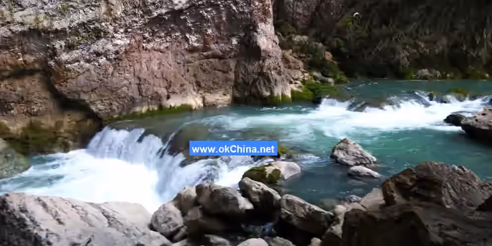
3.2.9 Laughing at the Sky River
This is another section of surface flow of the Fangcun River after its subterranean course. With a drop of 48 meters, the river's silvery waves roar thunderously, shaking the valley as if laughing at the sky, hence its name. The water emerges from a pile of rocks in the high-altitude karst area of Longding Village, Wangmeng Township, flows over 500 meters, and then goes underground again before reappearing at the Natural Bridge. This section has a steep riverbed and rapid currents. Viewed from above, it exudes a primitive, wild charm.
3.2.10 Large Entrance of Die Palace
This is the sinkhole where the Fangcun River (Qi River) flows through Die Gorge and enters the underground river of Die Palace. Viewed from outside, it is a large entrance over 100 meters high. Entering the cave via a side path reveals its features, including water caves and dry caves. Near the entrance, mushroom-like deposits are layered upon each other. As soon as the river water enters the cave, there is a sinkhole where most of the water churns away. A smaller portion of the water flow enters from the cave bottom, forming layered underground rivers. The scenery is incredibly diverse and astonishing.
3.2.11 Frog Pond
Frog Pond has a circumference of several tens of meters. The pond banks are overgrown with intertwined weeds and thorns. The swampy area within the pond is inhabited by rare large tree frogs, tiger-striped frogs, local earth frogs, and stone toads. Here, one can frequently encounter frogs' natural enemies—snakes, such as king cobras, banded kraits, many-banded kraits, patterned oblique-scaled snakes, triangular ironhead snakes, and various other strange-looking venomous snakes. On summer days after rain, groups of frogs chorus together, their long and short calls intertwining to compose a joyful symphony echoing through this forested valley depression, from which Frog Pond derives its fame.
3.3 Shuichun River Scenic Area
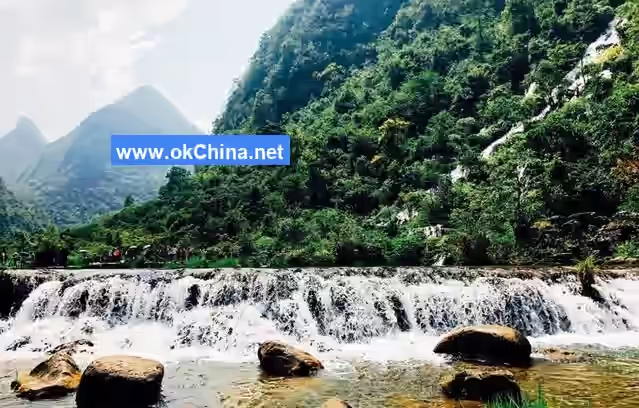
The Shuichun River Scenic Area is a 13-kilometer-long canyon in the upper reaches of the Zhangjiang River, also the longest canyon in the scenic area. Peculiar peaks and sheer cliffs constrict the riverbanks. The river, obstructed by massive rocks that have collapsed from both banks, forms the unique landscape of Shuichun River. Layers of mountains rise on both sides, pressing close to the river valley. The relative height difference between the opposing cliffs and perilous peaks is about 200 to 300 meters, while the water surface is only a few to over ten meters wide. This creates the perilous and spectacular landscape of "thirteen waves and seven rapids," making it a renowned destination for rafting adventures. Major attractions include Plum Beach (also known as "Courage-Testing Wave"), Bitter Bamboo Beach, White Dragon Wave, White Stone Beach, Natural Picture, Horse Urine Beach, Sister Peaks, Sister Beach, Carefree Wave, Long Wave, White Cliff, Dragon King Cave, Sunset Return Picture, etc.
3.4 Zhangjiang Scenic Belt
The Zhangjiang Scenic Belt is one of the four major scenic areas within the Zhangjiang Scenic Area, with a total area of 15.1 square kilometers. It is a comprehensive tourism zone integrating ecological sightseeing, rural leisure, ethnic cultural experiences, and adventure sports.
4. Historical Legends
The legends of the Zhangjiang River are filled with mystery and romance. It is said that in ancient times, the Zhangjiang River basin was a dry and barren land where people lived in hardship. One day, a giant dragon descended from the sky and transformed into a clear river, nourishing the land and people on both banks. This river is today's Zhangjiang River. The dragon's scales turned into the pebbles in the river, its whiskers became the weeping willows by the riverbank, and its breath endowed the Zhangjiang River with a spring-like climate year-round and abundant produce. To express gratitude for the dragon's gift, local people held sacrificial ceremonies every year, praying for favorable weather and bountiful harvests. The legends of the Zhangjiang River not only reflect the local people's reverence and gratitude towards nature but also imbue the river with sacred cultural significance, becoming an important component of the ethnic culture in the Zhangjiang River basin.
Comments
Post a Comment