
Hukou Waterfall of the Yellow River Tourist Area (Yan'an City, Shaanxi Province · Linfen City, Shanxi Province)
I. Introduction
The Hukou Waterfall of the Yellow River Tourist Area is a National Scenic Area and a National AAAAA Tourist Attraction. It borders Jixian County's Hukou Town in Linfen City, Shanxi Province to the east and Yichuan County's Hukou Town in Yan'an City, Shaanxi Province to the west, making it a tourist area shared by the two provinces. It is located 350 kilometers south of Xi'an City, Shaanxi Province, and 387 kilometers north of Taiyuan City, Shanxi Province.
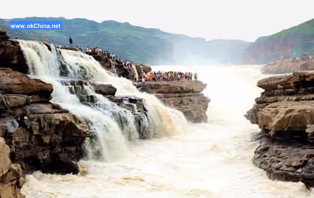
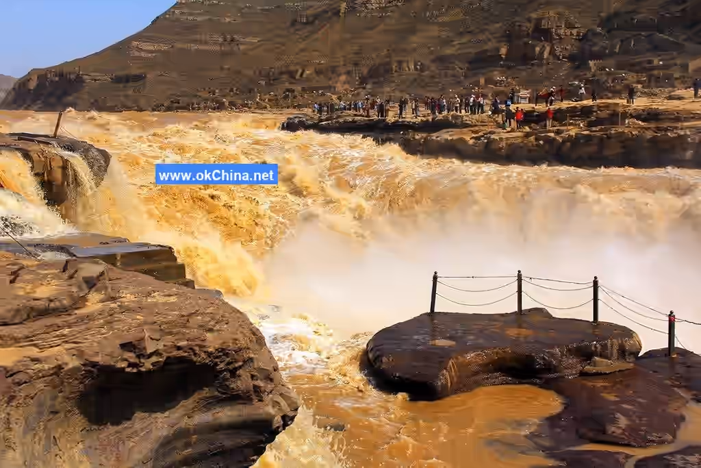
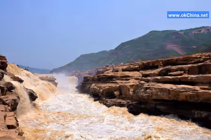
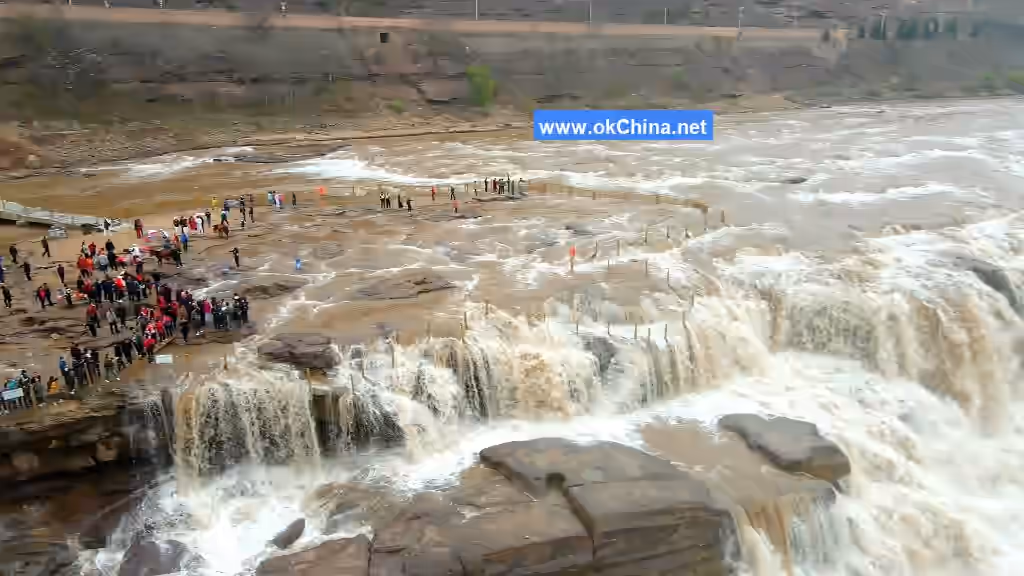
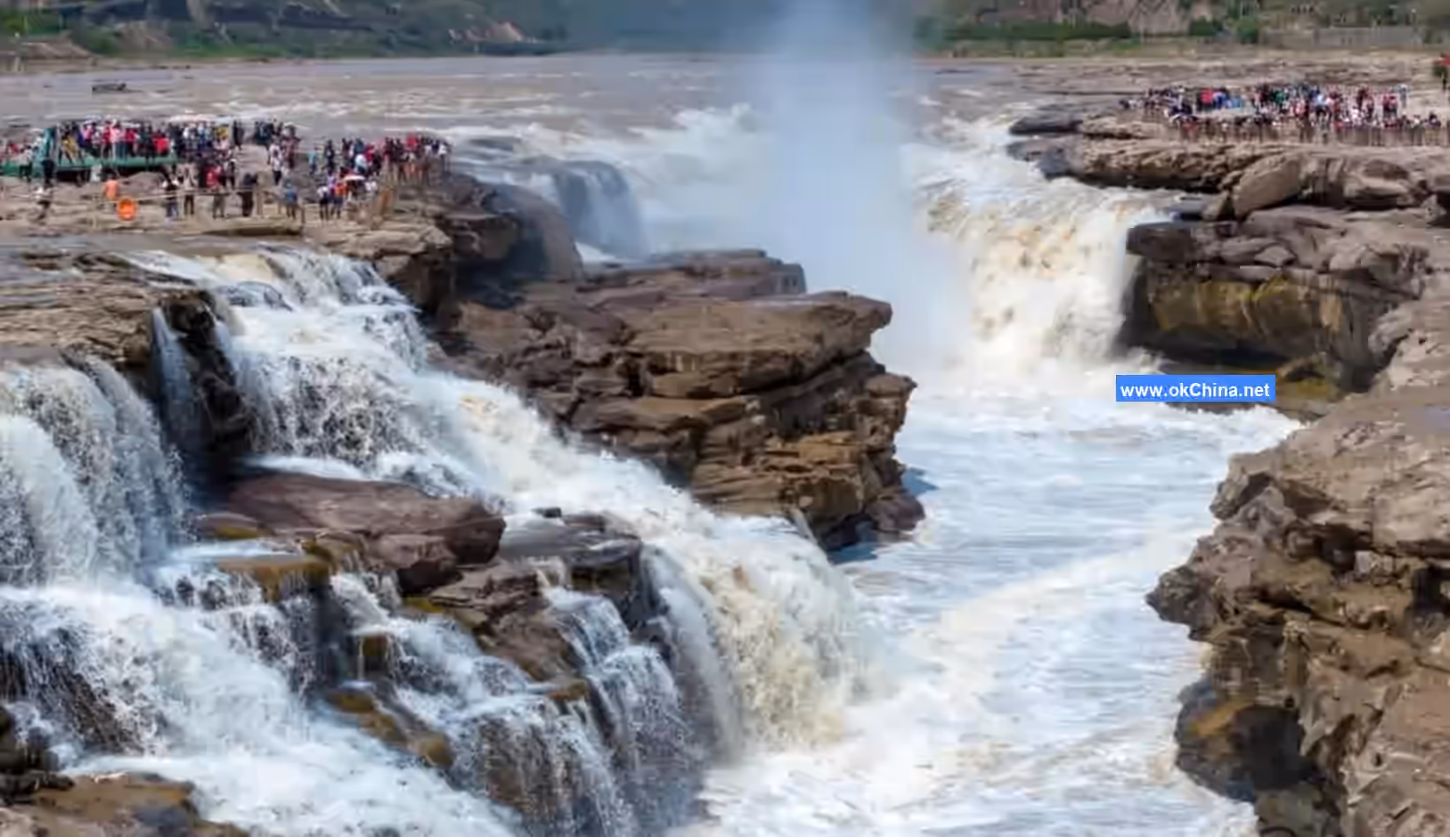
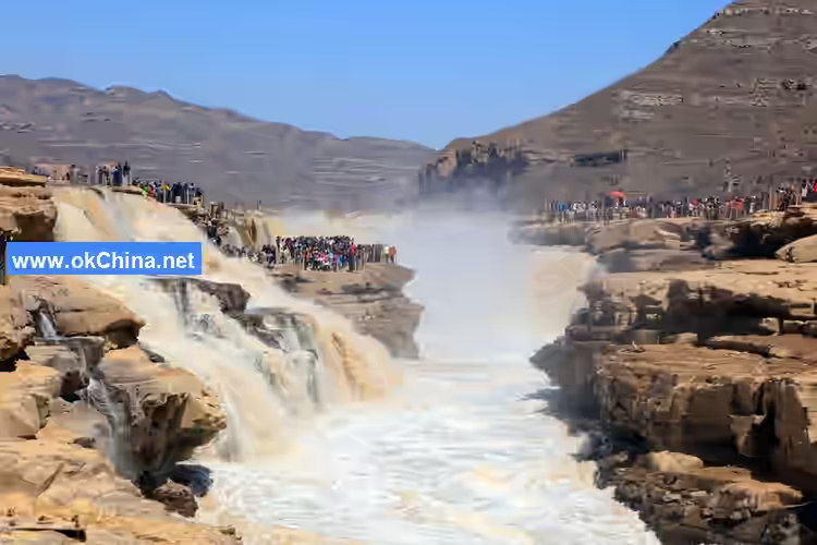
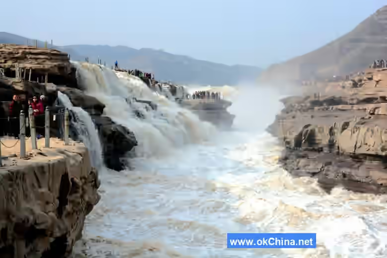
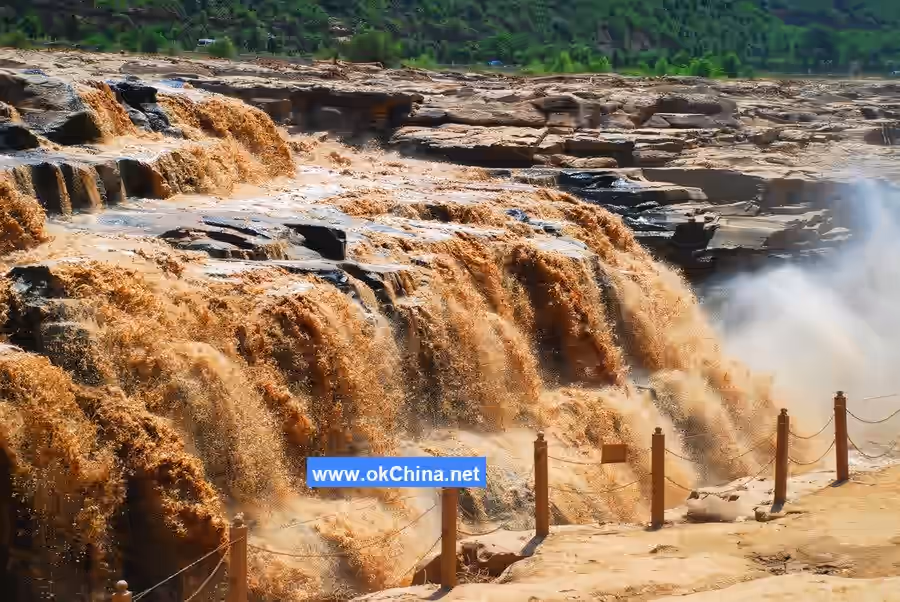
Hukou Waterfall is the second largest waterfall in China and the world's largest yellow waterfall. The Yellow River flows here where the cliffs on both banks are steep and the river mouth narrows like a pot's spout, hence the name Hukou (Pot Spout) Waterfall. Upstream, the Yellow River is 300 meters wide, but within a distance of less than 500 meters, it is compressed to a width of 20-30 meters. Water flowing at 1000 cubic meters per second pours down from a steep cliff over 20 meters high, creating the majestic spectacle of "a thousand miles of the Yellow River collected into one pot."
II. Historical Origin
The name "Hukou" first appeared in the Warring States period text Shang Shu·Yu Gong (Book of Documents·Tribute of Yu), in passages such as "Having dealt with Hukou, he regulated Liang and Qi" and "From Hukou and Leishou to Taiyue," all related to the route and strategy of Yu the Great's flood control efforts. Here, Hukou is mentioned but not the waterfall.
The name "Mengmen Mountain" first appeared in the work Shan Hai Jing (Classic of Mountains and Seas) from around the Zhou to Qin periods. It records: "Three hundred and twenty li further southeast is Mengmen Mountain. On its top there is much dark jade, below there is much yellow earth, and much black stone."
In Shui Jing Zhu (Commentary on the Water Classic) by Li Daoyuan, Mengmen and the waterfall are described in detail: "Huainanzi says: Before Longmen was opened and Lüliang was chiseled, the river emerged above Mengmen, flooding in great reverse flow, with no hills or high mounds to stop it; it was called the Great Flood. Yu the Great dredged it, and it was called Mengmen. Therefore, The Travels of King Mu says: Ascending north, Mengmen is the step of the Nine Rivers. Mengmen is indeed the upper mouth of Longmen, a great obstruction of the Yellow River, also bearing the name Mengjin. This rock was first chiseled by Yu; the river channel was widened by erosion, the banks became high and deep, cliffs leaned precipitously, and huge rocks perched dangerously, seeming about to fall yet still leaning. The ancients said, 'Water, though it does not chisel stone, can enter it.' How true! Within, the water flows crosswise, white vapor floats like clouds; those viewing from afar often feel as if mist and dew dampen them, and peering into the depths stirs the soul. The water still sends forth crashing waves ten thousand fathoms high, hanging streams a thousand zhang long; the turbid flood rages furiously, drumming the mountains as if they soar; swirling waves collapse in mounds, reaching the lower outlet. Only then does one understand Shenzi's account of floating bamboo down Longmen, not even a team of four horses could catch it." This account points to the waterfall at Mengmen but does not mention Hukou on the main stream of the Yellow River.
Yuanhe Junxian Zhi (Geographical Records of the Yuanhe Reign Period) also describes Hukou, calling it a stone trough. One passage says, "There is a mountain in the river, chiseled in the middle like a trough, constricting the flow which hangs and pours down over seventy-some feet." Another says, "The stone trough is one thousand paces long and thirty paces wide." This clearly differs from Li Daoyuan's description, indicating that Hukou Waterfall had shifted upstream. Yuanhe Junxian Zhi was compiled in the 8th year of the Yuanhe reign of Emperor Xianzong of Tang (813 AD), 286 years after Li Daoyuan's death in the 3rd year of the Xiaochang reign of Emperor Xiaoming of Northern Wei (527 AD). This shows that in the 286 years after Li Daoyuan, Hukou Waterfall retreated upstream from Mengmen by one thousand paces, scouring out a deep trough in the riverbed about one thousand paces long and thirty paces wide. It has now shifted further upstream to near Longwangchan, about 5 kilometers from Mengmen, known as the Ten-Mile Dragon Trough. The above is the history of Hukou's evolution over 1500 years.
Currently, four places named Hukou are known within Shanxi Province. The Hukou recorded in Shui Jing Zhu·Fen Shui Zhu (Commentary on the Water Classic·Fen River Commentary) is not the Hukou on the main stream of the Yellow River. Additionally, due to inconvenient ancient transportation, few literati and scholars could personally visit Hukou Waterfall for sightseeing and investigation. Therefore, in some ancient documents, other places named Hukou were mistaken for the Yellow River's Hukou; Hukou and Longmen were sometimes conflated as one place; positional errors were propagated, inevitably leading to some fallacies.
Before liberation, Wu Bing, the compiler of the earliest of Yichuan County's three local chronicles, the Yichuan County Chronicle from the 18th year of the Qianlong reign of the Qing Dynasty (1753), pointed out that the Yellow River's Hukou is where "the upstream is broad, but here it constricts and returns to the trough, like the mouth of a pot, hence the name." He also said Mengmen "belongs to Pingzuo Li, located 100 li northeast of the county in the middle of the Yellow River. No matter how high the water rises, it can never submerge it." His article "Hukou Kao" (A Study of Hukou) corrected some inaccuracies in previous documents and holds important reference value in Hukou research.
III. Geographical Location
Location and Territory
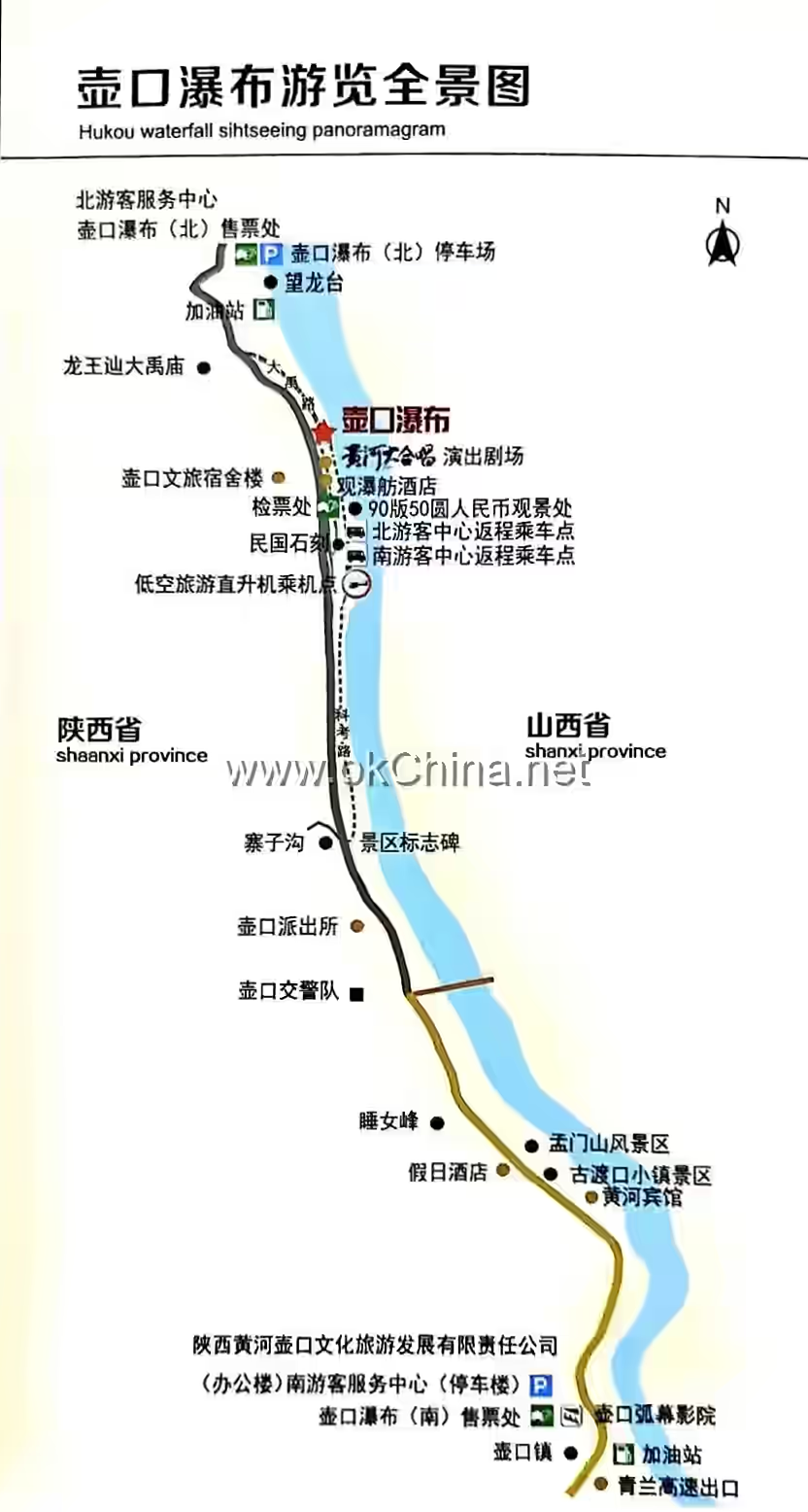
Hukou Waterfall is located in the southern section of the Qin-Jin Gorge, about 65 kilometers south of Longmen and 5 kilometers from Mengmen. The west bank belongs to Yichuan County, Shaanxi Province, while the east bank connects to Jixian County, Shanxi Province. It is a large canyon waterfall landscape in China.
Geographical Features
In the Hukou area, the west bank of the Yellow River is steep below and gentle above. The canyon floor is about 400 meters wide. From the canyon floor up the slope to Longwangpo, the height is about 150 meters, with very steep cliffs. Above Longwangpo, the canyon widens, and the slopes become gentle. The cross-section of the Yellow River takes on a "valley within a valley" form. North of Longwangchan, the river's width matches the gorge width, and the water fills the gorge. The normal water level flow is between 1000-3000 cubic meters per second, with a surface width of over 400 meters. Below Longwangchan, the water flows to Hukou, where it scours a deep trough in the flat canyon floor (a small river channel within the large river channel). The small channel is 30-50 meters wide and about 30 meters deep. Above Hukou, the water flows in the wide channel. Upon reaching the upper end of the deep trough, the 400-meter-wide water surface suddenly pours entirely into the 30-50-meter-wide deep trough, forming the waterfall. Here, the riverbed resembles a huge teapot, collecting the ceaselessly flowing Yellow River water, hence the name Hukou. The Ming Dynasty poet Hui Shiyang's verse, "Originating from Kunlun, it expands into a great flow; through nine turns at Yumen Pass, one pot collects it all," is a true depiction of this scene. Hukou Waterfall is extremely spectacular. The surging yellow water pours down, with rushing torrents, rolling muddy waves, splashing spray, misty haze, roaring waves, and sound shaking the area for several kilometers. The waterfall's height can reach 15-20 meters during the dry season and up to 45 meters in summer and autumn. During floods, the rolling torrent overflows the deep trough, and the waterfall transforms into a rushing flow downstream, with the waterfall form disappearing. The water travels 5 kilometers along the deep trough to reach Mengmen. After exiting Mengmen, the water surface widens, the current slows, and the scene returns to that above Longwangchan.
IV. Main Attractions
The Waterfall
Accompanying the waterfall is a series of unique sights, mainly eight wonders, known as: Smoke from the Water Bottom, Boat Sailing on Dry Land, Rainbow Playing in Water, Mountains Flying and Seas Standing, Rain from a Clear Sky, Thunder on a Dry Day, Ice Peaks Hanging Upside Down, and the Ten-Mile Dragon Trough.
Smoke from the Water Bottom
Where the Yellow River enters the "Pot Spout," the turbulent flow rushes down, churning up water mist that rises into the air, connecting clouds to sky, resembling billowing thick smoke emerging from the water bottom, visible from over ten kilometers away.
The size of the mist at Hukou is related to the season and flow rate. In winter, the river surface freezes, the waterfall often turns to ice, surface runoff decreases, and Hukou's flow drops to 150-500 cubic meters per second. The falling water creates little surge, and very little spray flies out of the trough. In summer, the flow increases greatly, water overflows the deep trough, the drop is minimal, the waterfall disappears, and dense mist rising high into the air is not easily formed. In spring and autumn, the flow is moderate, temperatures are not high, the waterfall drop is over 20 meters, and the rushing torrent creates a great mist弥漫 in the air, forming the scene of "Smoke from the Water Bottom."
Boat Sailing on Dry Land
The great drop of Hukou Waterfall, combined with the long, narrow, deep trough below, and the湍急水流, makes passage very difficult for watercraft. Boats traveling downstream from above Hukou had to first dock at Longwangchan above Hukou, unload all cargo, and switch to human porters and animal pack trains to transport goods along the riverbank to downstream docks. Simultaneously, manpower was used to pull the empty boats out of the water. Round wooden rollers were placed under the boats, supporting them as they rolled along the riverbank. At a point downstream of Hukou where the current was slower, the boats were put back into the water, reloaded with cargo, and continued downstream. Pulling boats on land required great effort, often needing hundreds of people straining at tow ropes. Despite the round wooden rollers placed under the boats, the stone riverbank was still scarred with streaks from the iron nails on the boat bottoms. Under the conditions of the time, "Boat Sailing on Dry Land" was likely the best choice for water transport to bypass Hukou Waterfall, suited to the relatively flat stone riverbanks above and below the waterfall. Due to the rapid extension of highways and railways, and the construction of the Yellow River Bridge near Hukou, water transport past Hukou has been blocked for many years. Today, only traces left by past boat traffic can be seen.
Rainbow Playing in Water
The water mist formed by the repeated impact of Hukou Waterfall rises into the air, refracting sunlight to form rainbows. Sometimes the rainbow appears as an arc插入 the water from the horizon, like a long dragon drinking water; sometimes as a straight colored band across the water surface, like a colorful bridge; sometimes within the rising smoke and mist appear clusters of flowers, multicolored and dazzling, elusive and bewildering—a wonder of the world.
Rainbow Playing in Water is the product of the combined effects of "Smoke from the Water Bottom" and sunlight. In spring and autumn, with smoke from the water bottom and high-hanging dense mist, on clear days,斜射 sunlight often forms rainbows; in summer after rain clears, rainbows sometimes also appear.
Mountains Flying and Seas Standing
"Mountains Flying and Seas Standing" describes the磅礴气势 of Hukou Waterfall. The Yellow River traverses the thousand-mile-long gorge, its surging激流直逼 Hukou, suddenly constricting into the trough, forming an extremely壮观飞瀑. Looking up at the water curtain, the rolling yellow water倾泻而下 from the horizon, with the force of a thousand mountains collapsing and four seas倾倒,构成 the core景观 of Hukou Waterfall.
Rain from a Clear Sky
The hanging waterfall飞流, forming water mist that floats and rises. Even under a blazing sun, near the waterfall it feels like濛濛细雨, dampening clothes. This is another interesting景观 produced by Smoke from the Water Bottom. Generally, the closer to the river surface, the denser the mist. Therefore, when there is smoke from the water bottom, viewing the waterfall from the bank inevitably leaves clothes damp, as if lightly washed.
Thunder on a Dry DayThe Yellow River surges through the gorge, its turbulent waves like a mighty army, roaring and thundering, shaking the valley. When the waterfall plunges down, repeatedly striking the rocks and water surface, it produces a tremendous sound that echoes through the mountains, akin to ten thousand drums beating in unison or thunderclaps in a dry sky, audible over a dozen miles away. Only near the Hukou Waterfall can one truly feel "the Yellow River roaring" and "the Yellow River raging."
Inverted Ice Peaks
In the depths of winter, the Long Trough freezes over, and the water columns formed by the overflowing streams on both banks hang like ice peaks of varying sizes inverted from the cliffs. Rainbows appear and disappear intermittently, drifting among them, with the seven colors contrasting against the crystalline ice, leaving visitors in awe of nature's wonders.
Ten-Mile Dragon Trough
From Hukou to Mengmen is about 5 kilometers. At the bottom of this 400-meter-wide box-shaped gorge, the Yellow River has carved a trough 30–50 meters wide and 10–20 meters deep. After rushing down from Hukou, the Yellow River converges into this trough with a massive flow of thousands of cubic meters per second. Legend has it that it was carved by a dragon, and as it is approximately 10 Chinese miles long, it is named the "Ten-Mile Dragon Trough," also known as the "Ten-Mile Dragon Moat." It was formed as the Hukou Waterfall retreated upstream, and the deep pool beneath it continuously extended. This deep trough is embedded in the bedrock riverbed of the original valley floor, with most of the original riverbed beside it becoming the riverbank during non-flood periods. These banks are relatively wide and flat, composed entirely of hard sandstone. Near the water, there is almost no sand or gravel, and the flat surface is even suitable for vehicles—the practice of "dry land boat transport" utilized precisely these geological and topographical conditions.
From the high riverbanks, the "Dragon Trough" and the flow of the Yellow River are almost invisible. Only a line of churning, muddy water can be seen in the purplish-brown bedrock riverbed, accompanied by the ceaseless roar of the surging waves. The torrent in the trough resembles a pot of boiling water, rushing left and right, tumbling and rolling downstream, with the mist it stirs up shrouding the Dragon Trough, making the Yellow River here appear hazy and indistinct. During flood seasons when the Yellow River rises, the overflowing water spills over one end of the Hukou Dragon Trough, creating a curtain of flowing water one to two kilometers long on the eastern bank, a spectacular sight. From a distance, the winding stone trough in the gorge looks like a dragon swaying its head and tail, with Hukou as the head, swallowing the mighty flow of the Yellow River, and Mengmen as the tail, discharging the water downstream.
Yuanyang Pot
When the Yunyan River in Yichuan County, Shaanxi Province, experiences a short-term rise in water level, the sediment-laden water flows into the Yellow River. Since the confluence of the Yunyan River and the Yellow River is only three to four kilometers from the Hukou Waterfall, a peculiar "Yuanyang Pot" phenomenon occurs, with muddy waves churning on the west side and clear streams rushing on the east side.
Mengmen Mountain
About five kilometers downstream from the Hukou Waterfall, below the "Ten-Mile Dragon Trough," two spindle-shaped boulders stand majestically in the torrent on the riverbed of the Yellow River valley, forming two river islands. These are the Mengmen Mountain, historically known as the "Stepping Stones of the Nine Rivers." Legend has it that these two islands were originally one mountain that blocked the river, causing floods to overflow. During Yu the Great's flood control efforts, he split the mountain in two to guide the water flow. Viewed from afar, these islands resemble boats; up close, they look like mountains; and from above, they appear as gates. Another legend tells of descendants of the Meng brothers being swept away by the river and rescued here, hence the name Mengmen Mountain.
The larger Mengmen Island is about 300 meters long, 50 meters wide, and rises about 10 meters above the water. On its southern cliff, four large characters—"Wò Zhèn Kuáng Liú" (Calming the Raging Torrent)—were inscribed by Xu Huanying, the prefect of Jinming during the early years of the Yongzheng reign in the Qing Dynasty. The plaque is 2.5 meters long and 1 meter wide, a true depiction of the landscape here. The smaller Mengmen Island is located about 10 meters upstream from the larger one, only 50–60 meters long. Both islands are composed of horizontally layered, blocky gray-green sandstone, which is hard and highly resistant to weathering.
Mengmen stands tall against the surging muddy torrent, enduring the towering waves year-round without being submerged. "To the south, it connects with the ancient spirit of Longmen; to the north, it pulls a thread of sky from Hukou." Its majestic presence, together with Longmen and Hukou, forms the three wonders of the Yellow River, yet it is renowned for its unique charm. An ancient poem praises it: "In all seasons, mist and rain obscure Hukou; on both banks, waves shake Mengmen."
Historical records contain numerous references to Mengmen, and local folklore abounds with tales about it. According to Geographical Knowledge, Mengmen was originally a knickpoint on the Yellow River's bed, where the Hukou Waterfall once appeared. Over time, due to crustal uplift and enhanced river downcutting, the knickpoint migrated upstream, moving the waterfall to its current location. The deep pool beneath the waterfall evolved into the "Ten-Mile Dragon Trough," while Mengmen Mountain is the remnant rock mass left behind as the waterfall's pool migrated.
Although Mengmen Mountain can hardly be called a "mountain," its unique scenery is captivating. The Qing Dynasty poet Nan Peng wrote in a poem: "I heard Mengmen was small, but seeing it, it’s as big as a fist. A scene fit for a scholar’s desk, as if suspended in a painting."
Mengmen on the Yellow River is not only enchanting, with the beauty of "Mengmen's Moonlit Night," but also holds significant scientific value in studying the developmental history of the Yellow River.
Wonders of the Yellow River
"Ice Bridges" and "River Shrinkage" are two remarkable phenomena related to changes in the Yellow River's surface near Hukou.
Yellow River Ice Bridges
In the depths of winter, the Yellow River surface near Hukou freezes over. In some sections, the ice layer is thick enough to form a natural bridge connecting both banks, known as the Yellow River Ice Bridge.
The freezing period begins when a stable ice cover forms on the river surface and ends when the ice cover breaks and water starts flowing again. The freezing period typically starts between December 10 and 20 and ends between February 20 and 25 of the following year, lasting generally 50–70 days. During this time, the Ten-Mile Dragon Trough is covered in ice and snow, with the ice layer "forming ice floes during Light Snow and bridging during Heavy Snow." In the coldest days, the ice layer can rise above both banks, creating not only a spectacular sight but also an ice bridge. When the river first freezes, people observe the footprints of foxes and other wildlife to determine that the ice is thick enough to cross. Hence, the folk legend of the "fox fairy marking the path."
Yijin Ferry in Yichuan faces Fengjiaqi in Jixian County, Shanxi, across the river. In winter, the ice is solid enough for heavy traffic. Located upstream from Hukou, this ice bridge is called the "Upper Bridge." When the river surface freezes near Longwangchan and Qilangwo, it becomes as flat as a thoroughfare, with a constant flow of people and horses, earning it the names "Old Bridge" and "Divine Bridge."
Historical records note that in the third year of the Chongzhen reign of the Ming Dynasty (1630), Wang Jia, a general of Li Zicheng's rebel army, led his troops across the "ice bridge" near Hukou when the Yellow River froze, capturing Jixian County in Shanxi. In the late Qing Dynasty, the Western Nian Army, operating in northern Shaanxi, crossed the Yellow River ice bridge at West Longwangchan in 1866 under the command of Prince Liang Zhang Zongyu, traversing the Lüliang Mountains to aid the Eastern Nian Army. The Yellow River ice bridges historically played a role in promoting economic, cultural, and interpersonal exchanges between Shaanxi and Shanxi.
Yellow River Shrinkage
When the Yellow River's water volume drastically decreases, the surface narrows, the water becomes shallower, and sometimes the river clears temporarily or nearly dries up, locals refer to it as "Yellow River Shrinkage." This is a rare natural anomaly, regarded as a wonder of the Yellow River. Historical records indicate that the Yellow River in the Yichuan and Jixian sections has experienced multiple instances of shrinkage.
Xilongzhang Plateau
Xilongzhang Plateau stretches from Taoqu in the north to north of Gancao in the south, bounded by the cliffs of the Shanxi-Shaanxi Gorge to the east and west of Anle Mountain to the west. Its landscape features typical Loess Plateau scenery and plateau villages, with vast open fields on the plateau.
Mangtou Mountain
Mangtou Mountain National Forest Park is located in the eastern part of Yichuan County, Yan'an City, Shaanxi Province, with an elevation of 800 to 1,439 meters and a total area of 2,120 hectares. The forest coverage rate is 89.1%. It is divided into three scenic areas: Our Lady's Hall, Shihua Mountain, and Wangmang Village, with over thirty scenic spots. The park is densely forested, featuring coniferous and broad-leaved mixed forests dominated by lacebark pine, oriental arborvitae, and Liaodong oak. It hosts over 400 species of higher plants, including more than 100 woody species, and is home to China's largest secondary forest of lacebark pine.
V. Cultural Activities
Natural History
The Loess Plateau, the Yellow River channel, the Shanxi-Shaanxi Gorge, as well as the Hukou Waterfall, Ten-Mile Dragon Trough, and Mengmen Mountain, are all products of nature and important natural historical relics. In addition, the following natural historical relics exist near Hukou:
High Terraces of the Yellow River
On rock surfaces 100 meters above the riverbed, there are accumulations of gravel layers 1–2 meters thick, collectively forming a high terrace of the Yellow River. This accumulation terrace is a product of the early development of the Yellow River and represents remnants of its ancient riverbed. Such high terraces also exist in some sections of the Shanxi-Shaanxi Gorge. They are of great significance for studying the developmental history of the Yellow River and the characteristics of crustal movements at that time.
Diphodocus Fossil Site
About 3 kilometers downstream from the Hukou Waterfall, Diphodocus fossils have been discovered, distributed over an area of approximately 40 square meters. Diphodocus lived millions of years ago. The discovery of this paleontological fossil site is significant for studying the ancient geographical environment around Hukou.
Minor Loess Landforms
Loess plateaus, hills, ridges, and the gullies between them are large-scale loess landforms. Minor loess landforms include loess pillars, sinkholes, bridges, walls, and caves that appear on the edges of steep loess cliffs. Around Hukou, on the fragmented edges of the loess plateaus along both banks of the Yellow River, such minor loess landforms are widely distributed.
On the cliff north of the Shiwang River Valley, about 15 kilometers from the Chuanhe River estuary, there is a natural bridge. The bridge is 6–7 meters long, 1.5–3 meters wide, with a flat top that projects into the air, presenting a remarkably perilous sight.
About 10 kilometers east of Yichuan County, on the southern bank of the Jingyang Village River, halfway up the Black Fir Ridge, there is a stone cave called Baiyun Cave (White Cloud Cave). The entrance is square, only allowing one person to crawl through. Inside, it suddenly widens, permitting standing and walking. Within, there are stalagmites resembling pagodas, 2–3 meters high, smooth and lovely.
Rare Plant—Purple-Spotted Dwarf PeonyYichuan was anciently known as Danzhou, a name said to derive from its abundant peonies. According to old county records: "Thirty li east of the county seat, on the Dongshan (East Mountain) of Xingji Town (now the location of Qiulin Township government), there is a place called Mudan Yuan (Peony Plateau). In the past, it produced many peonies that bloomed in the wild during summer and autumn. The flowers covered the hills, their fragrance carrying for dozens of li. Unfortunately, no one cultivated them, and the locals gathered them for firewood." This refers to a wild peony species, the purple-spotted dwarf peony, a wild variant. Once widely distributed across northern Shaanxi, contiguous stands are now rare, making it a precious plant species deserving protection.
As early as the Tang and Song dynasties, Yichuan was not only one of the four famous peony-producing regions, but its 'Danzhou Yellow' peony variety was already transplanted as a prized cultivar to Luoyang in Henan. Among Luoyang's earliest eight peony gardens, the first was the "Danzhou Garden." The renowned Song dynasty literary figure Ouyang Xiu, in his Record of Luoyang Peonies, wrote descriptions such as "Peonies come from Danzhou" and "Danzhou Yellow, a thousand-petaled yellow flower." Danzhou peonies sprout buds on their stems in the second lunar month, send out shoots resembling kiwi fruit in the third month, and produce round, green autumn fruit. The peony root bark produced is thick and fleshy, presenting a reddish-brown color. Li Shizhen praised it in the Compendium of Materia Medica: "The root bark of Danzhou peony is especially excellent for medicinal use." Due to long-term firewood gathering and human disturbance, the once contiguous wild peony stands are now scattered sparsely across some ridges, their numbers few.
Cultural History
Ancient Ferries and Market Towns
Among the ancient ferries and market towns, Donglongwangchan on the east bank and Gezhentan on the west bank were the largest in scale. Additionally, ferries on the west bank like Yijindu, Xiaohekou, and Guantoudu faced opposite points on the east bank: Fengjiaqi, Mafentan, and Hamatan, respectively. The reason numerous ferries formed above and below the Hukou waterfall is that the Hukou Falls presented a natural obstacle to water transport on the Yellow River, dividing the waterway into two segments. Boats traveling in either direction would dock at a ferry before reaching Hukou to unload cargo. The boats were then hauled overland ("dry-land boat hauling") past the waterfall to another ferry downstream, where they were reloaded to continue by water. Furthermore, frequent economic exchange between Qin (Shaanxi) and Jin (Shanxi), coupled with the convenience of ice bridges in winter, led to the emergence of these ferry points. At that time, these ferries served as distribution hubs for waterborne goods moving north, south, east, and west in the middle reaches of the Yellow River. The Yellow River water transport through the Qin-Jin Gorge played a positive role in the economic development of regions like Inner Mongolia and the Central Plains, as well as Shaanxi and Shanxi.
Before the opening of the Beijing-Baotou railway, Yellow River shipping was highly developed. Donglongwangchan was one of the important water-land transfer points and commercially prosperous market towns along this section of the river. At that time, shipping would commence with the spring peach-flood season each March. Except for interruptions during periods of exceptionally heavy flood peaks in the rainy season, cargo boats sailed downstream continuously until the river began freezing around Lesser Snow and Greater Snow each year. People from the upper reaches, for the purpose of trade, would fell trees and build boats each winter. After spring arrived, they would load these boats with local products such as licorice root, red dates, grain, hides, animal bones, coal, porcelain, salt, and soda ash. These were transported via Hukou downstream to areas like Fenglingdu and Mengjin, where both boat and cargo were sold entirely. The crew would then return home on foot empty-handed. Aside from a few official vessels, most of these boats were merchant ships. In terms of grain capacity, large boats could carry over 9,000 kilograms, while smaller ones held around 6,000 kilograms. In normal years, four to five thousand boats would pass through the ferry. At its peak, Donglongwangchan could host over 1,000 moored boats, with several hundred people working as haulers for the "dry-land boat hauling." According to various stele inscriptions preserved at Donglongwangchan, this town flourished from the early Ming dynasty, prospered during the Qing dynasty—especially reaching its peak from the Qianlong to Daoguang reigns—and declined before the War of Resistance Against Japan, spanning approximately 400 years in total. A stele from the ninth year of the Tongzhi reign (1870), recording the repair of temples burned during the eastward crossing of the Nian Army, notes that 63 merchant houses donated funds for the temple repairs, including money shops, hide shops, pawnshops, salt shops, pharmacies, and shops selling goods from the capital (Beijing), indicating considerable economic activity.
The economic activity at Donglongwangchan ferry required not only corresponding commercial establishments but also a large-scale shipping organization to expedite the "dry-land boat hauling." Consequently, in the early Kangxi reign of the Qing dynasty, a folk porterage organization called "Liugutou" (Six Shares) emerged. This organization was primarily composed of six large villages near Hukou in Ji County: Nanyuan, Shangshi, Zhongshi, Liucun, Nancun, and Guxian. It was responsible for assigning porterage tasks, organizing labor, and distributing payments and taxes. This organization lasted until the 20th year of the Republic of China (1931). Over its 200-year existence, it played a positive role in promoting local economic prosperity and cultural exchange.
Additionally, places like Yijindu, Fengjiaqi, Gezhentan, and Xiaochuanwo were historically famous ferry crossings and shipping wharves. Mountain valley villagers, military troops, and merchants frequently traveled through them. Ancient ferry sites like Gezhentan still retain a relatively complete appearance of an old market town. The stone mooring holes on the bank and the mountain paths carved by boatmen into the stone cliffs remain as they were.
Remaining Military Sites
Mainly include:
- Qing Dynasty Great Wall. Built from the 5th to the 11th year of the Tongzhi reign (1866–1872), the Qing government deployed the Huai Army to construct this wall along the east bank of the Yellow River to block the eastward crossing of the Western Nian Army and ensure the safety of Beijing and Tianjin. The wall stretched 75 kilometers from Pingduguan in the north to Yukou in the south. Its outer wall was over 10 meters high with a top surface 5 meters wide, featuring gun platforms, battlements, passages, and fort gates. Donglongwangchan served as the central command post, housing command organs below the level of Provincial Military Commander and garrisoning 3,500 troops.
- Nancunpo and Mafentan. Nancunpo is located 5 kilometers upstream from Hukou on the east bank. Mafentan lies below Nancunpo. During the War of Resistance Against Japan, this was the location of the Nationalist Kuomintang's Second War Zone headquarters and the Shanxi Provincial Government, garrisoned for over five years. Remaining structures include large stone buildings like the "Zhonglie Ci" (Loyal Martyrs Shrine) and "Leqian Tang," well-preserved stone cave-dwelling complexes, a river-viewing pavilion, and hundreds of earthen cave dwellings used by the stationed troops. At that time, over 20,000 people were stationed there.
- Shibao Zhai (Stone Fortress). Located at the mouth of the Yunyan River upstream from Hukou, it is exposed on three sides with steep cliffs on the eastern bank overlooking the Yellow River. It is said to have been built during the Song-Jin period. The Western Nian Army once used it to confront Qing forces. Remaining features include the fortress gate, walls, and several dozen stone cave dwellings.
Additionally, places like Xiaochuanwo and Hamatan on the east bank formerly housed military garrison institutions.
Stone Carving Art
Due to the special geographical location and the importance of ancient economic and military activities in the Hukou area, people of the time recorded many significant events through stone inscriptions. Preserved major stone carvings include those at Donglongwangchan, of which over ten steles remain:
- Dragon King Temple Theatrical Performance Donation Stele and Rebuilt Music Tower Stele. These two steles were carved during the Jiajing reign and early Kangxi reign, respectively. Their inscriptions record the formation and economic activities of the Longwangchan market town.
- Ox and Horse King Temple Rebuilt Music Tower and Mountain Gate Stele, recording the prosperous period of Donglongwangchan as a water-land port and important market town.
- Stele Recording the Repair of Temples Burned During the Nian Army's Eastward Crossing, carved in the 9th year of the Tongzhi reign (1870), indirectly reflecting the economic conditions of Donglongwangchan at that time.
- Memorial Stele for Soldiers Fallen in Battle While the Qing Army Resisted the Nian Army's Forced Crossing of the Yellow River, providing important clues for studying the Nian Army's military activities.
- Official Stele, embedded in the stone cliff at the bank of the ancient Gezhentan ferry, records an incident of timber plundering during log rafting on the Yellow River. The entire stele is very well preserved.
- Menmen Stone Carving. Four large characters, "Wozhen Kuangliu" (Lying Calm Amidst Raging Currents), written by Xu Huanying of the Qing dynasty, are carved onto a giant rock at Menmen, vividly summarizing the natural characteristics of Menmen Mountain.
- Stone Carving from the 8th Year of the Republic of China (1919). This clearly defines the territorial scope and land management of the Hukou waterfall area on the Shaanxi side. It is an important historical document for the construction of the Hukou Waterfall Scenic Area (the original proclamation text is in the Cultural Relics Records).
Comments
Post a Comment