


Hukou Waterfall
I. Introduction
The Hukou Waterfall Scenic Area of the Yellow River is a National Scenic Spot and a National AAAAA Tourist Attraction. It borders Hukou Town, Jixian County, Linfen City, Shanxi Province to the east, and Hukou Town, Yichuan County, Yan'an City, Shaanxi Province to the west, making it a shared tourist destination between the two provinces. It is located 350 kilometers south of Xi'an, Shaanxi, and 387 kilometers north of Taiyuan, Shanxi.
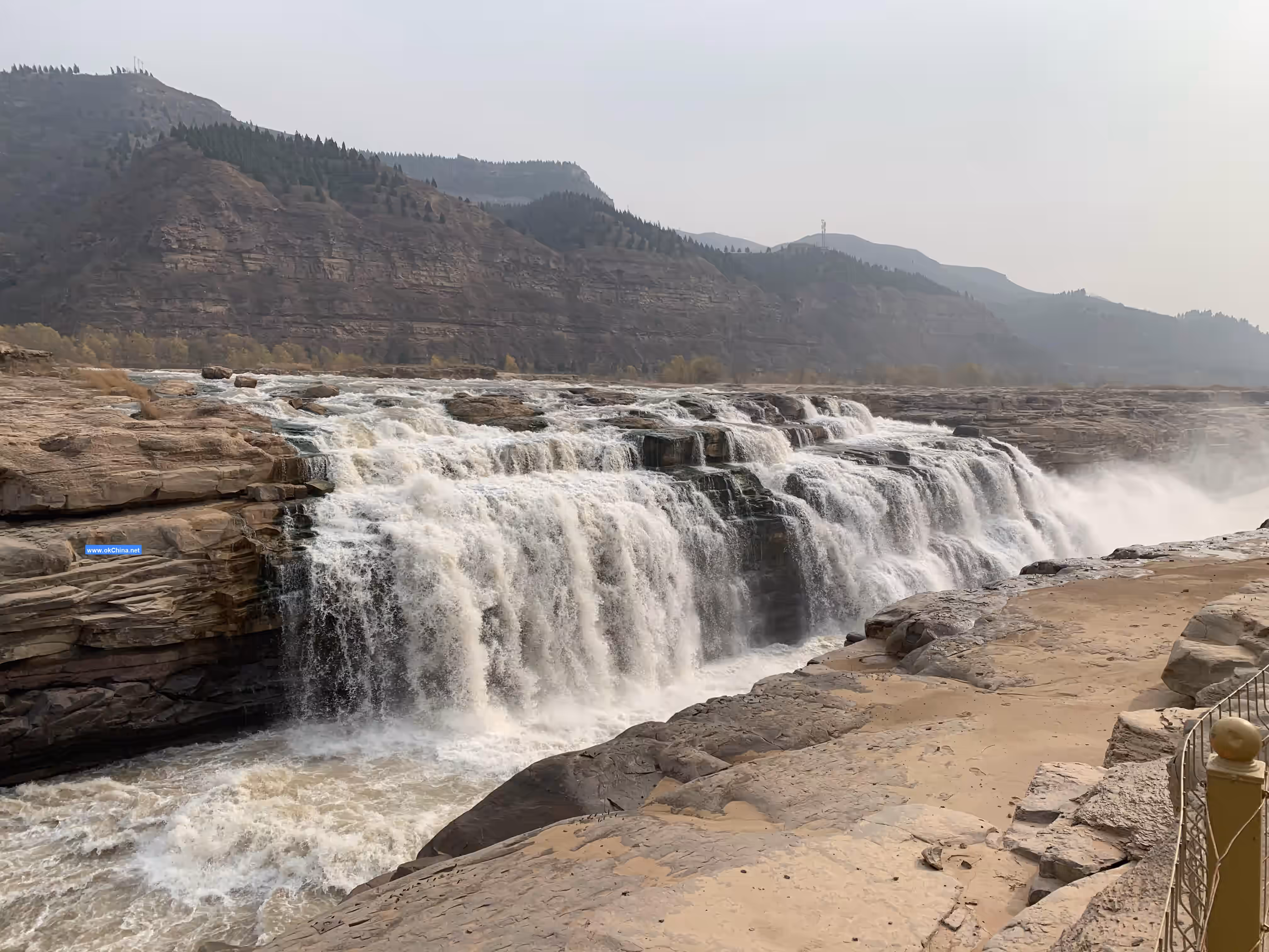
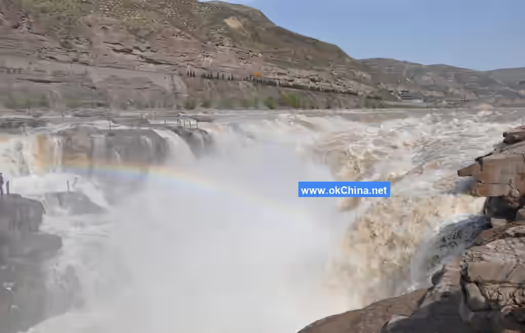
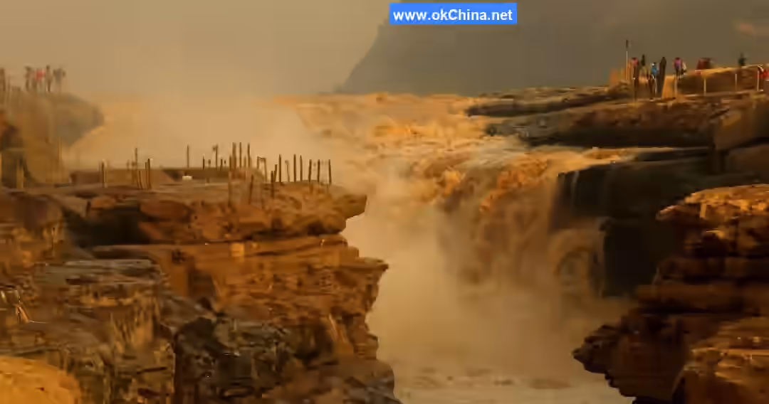
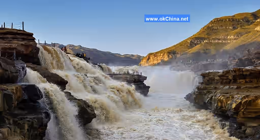
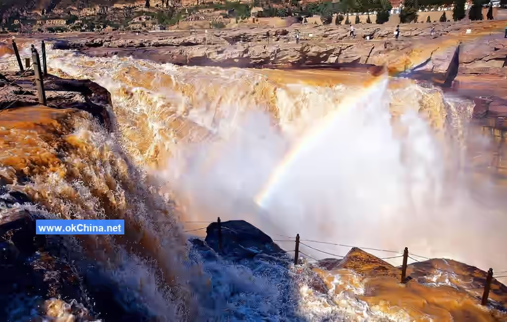
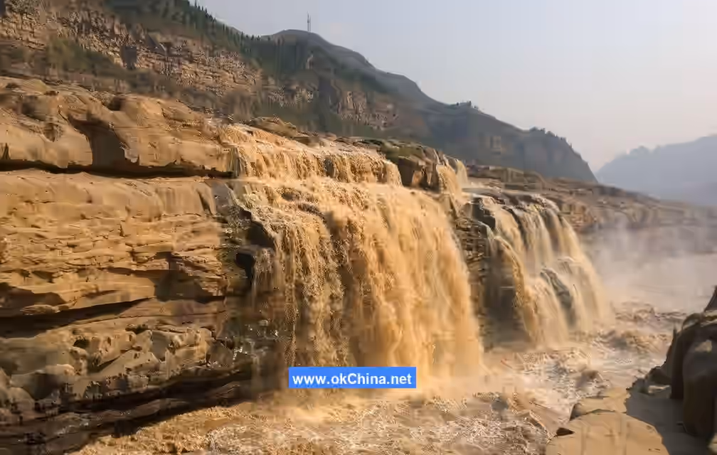
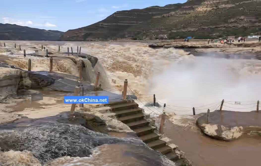
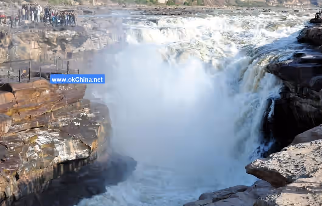
Hukou Waterfall is the second-largest waterfall in China and the world's largest yellow waterfall. The Yellow River flows rapidly to this point where the cliffs on both banks rise steeply, and the river mouth narrows like the spout of a teapot, hence the name "Hukou Waterfall" (Teapot Spout Waterfall). Upstream of the waterfall, the Yellow River is 300 meters wide, but within a distance of less than 500 meters, it is compressed to a width of 20–30 meters. Water flowing at 1,000 cubic meters per second plunges from a steep cliff over 20 meters high, creating the majestic spectacle of "the thousand-mile Yellow River gathered into one teapot."
II. Location and Layout
Location and Region
Hukou Waterfall is situated in the southern section of the Qin-Jin Gorge, approximately 65 kilometers south of Longmen and 5 kilometers north of Mengmen. The west bank belongs to Yichuan County, Shaanxi Province, while the east bank connects to Jixian County, Shanxi Province. It is a large-scale canyon waterfall landscape in China.
Climatic Characteristics
The area around Hukou Waterfall experiences a warm temperate, semi-humid, and semi-arid climate. The annual average temperature is 9.9°C, with the hottest month (July) averaging 23.3°C and the coldest month (January) averaging -5.7°C. The annual temperature range is 29°C, with extreme highs reaching 39.9°C and extreme lows dropping to -22.4°C. Annual precipitation is 577.2 mm, with about 60% concentrated in July, August, and September. Rainfall and heat occur in the same season, often accompanied by heavy rainstorms. The region has four distinct seasons: short and slightly hot summers, slightly longer, dry, and cold winters, and mild but variable spring and autumn seasons.
River System and Hydrology
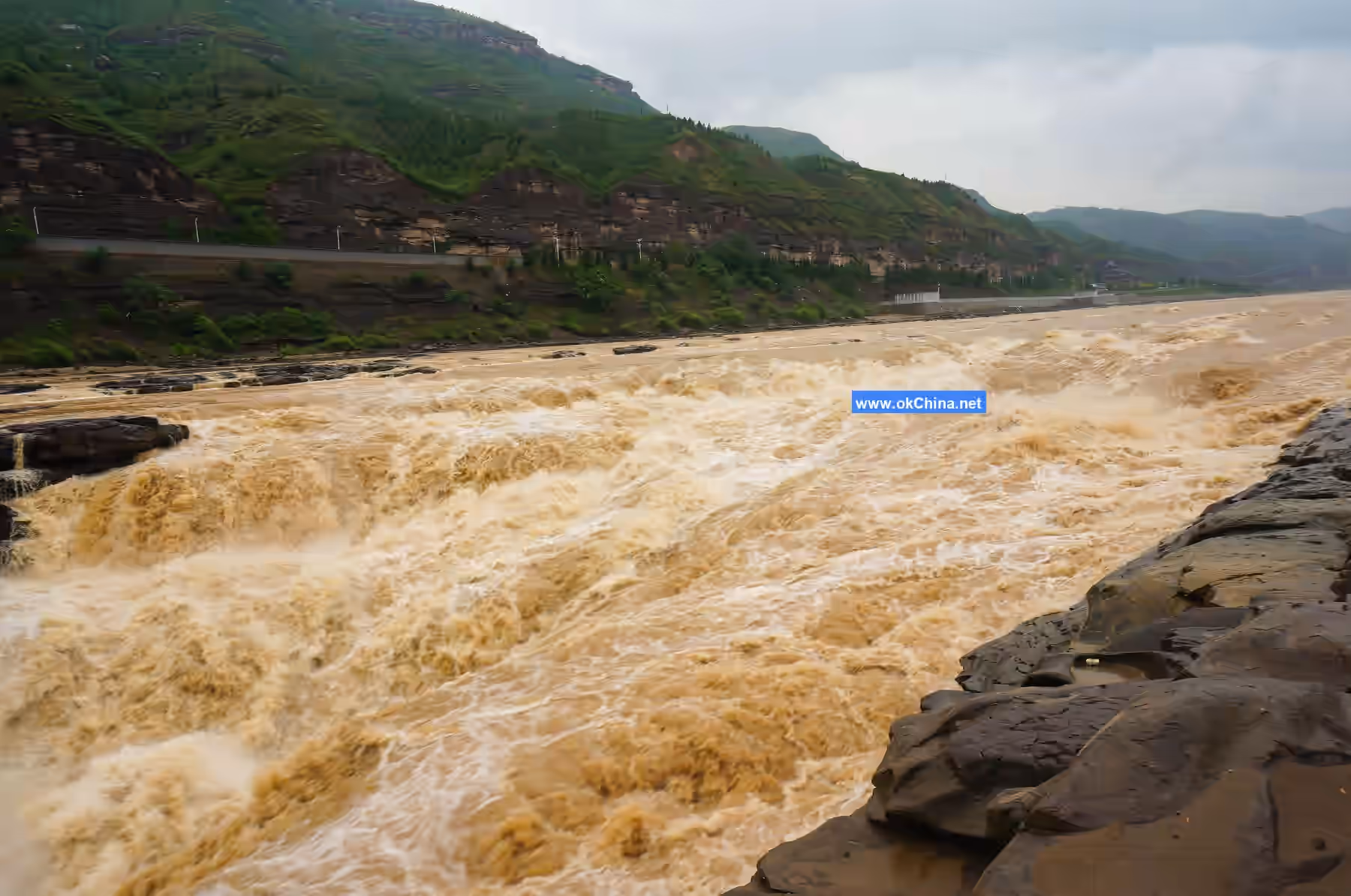
Rainstorms in the Qin-Jin Gorge basin cover a large area, last for a relatively long duration, and have high intensity. The maximum daily rainfall can reach 200–300 mm, making it one of the main source areas for floods in the middle reaches of the Yellow River. Floods in the middle Yellow River are characterized by high peak flows and short durations, with hydrographs showing a tall, thin shape. As the area primarily consists of loess hilly and gully terrain with significant surface relief and short concentration times, rainstorms lead to rapid runoff carrying both water and sediment into the Yellow River, forming floods with extremely high sediment content that strongly erode the riverbed. Observations indicate that the maximum flow near Hukou Waterfall during flood periods can reach 10,500 cubic meters per second. Furthermore, the average annual sediment input into the Yellow River from the Hekouzhen to Longmen section is 908 million tons, accounting for 55.7% of the Yellow River's total annual sediment load.
In July 2024, the Yellow River's Hukou Waterfall entered its flood season. On August 8, 2024, Hukou Waterfall experienced the largest flood flow of the year, with a maximum flow exceeding 1,500 cubic meters per second. The main and subsidiary waterfalls merged into a continuous line, stretching over 200 meters wide, once again presenting the spectacular sight of a massive yellow waterfall group.
III. Geological Features
Geographical Form
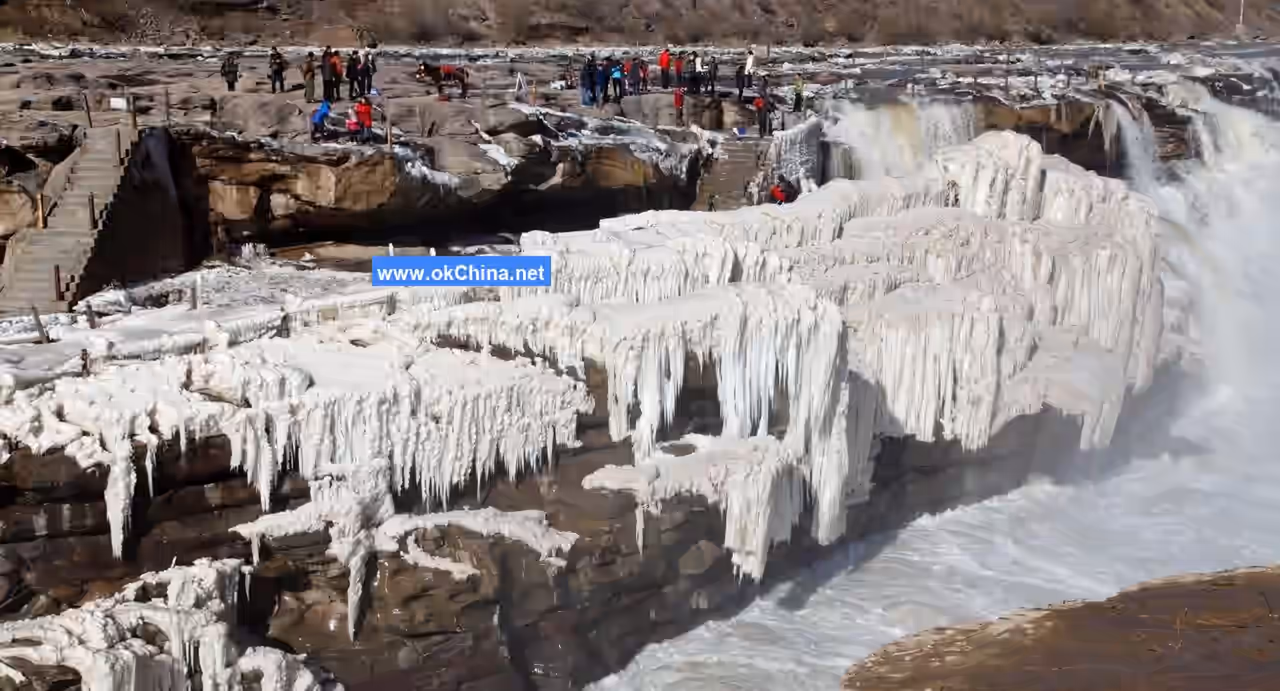
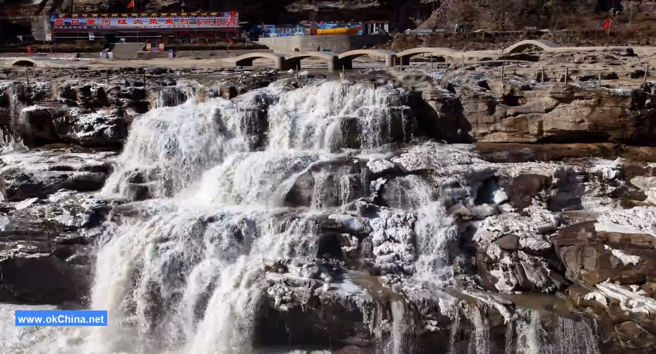
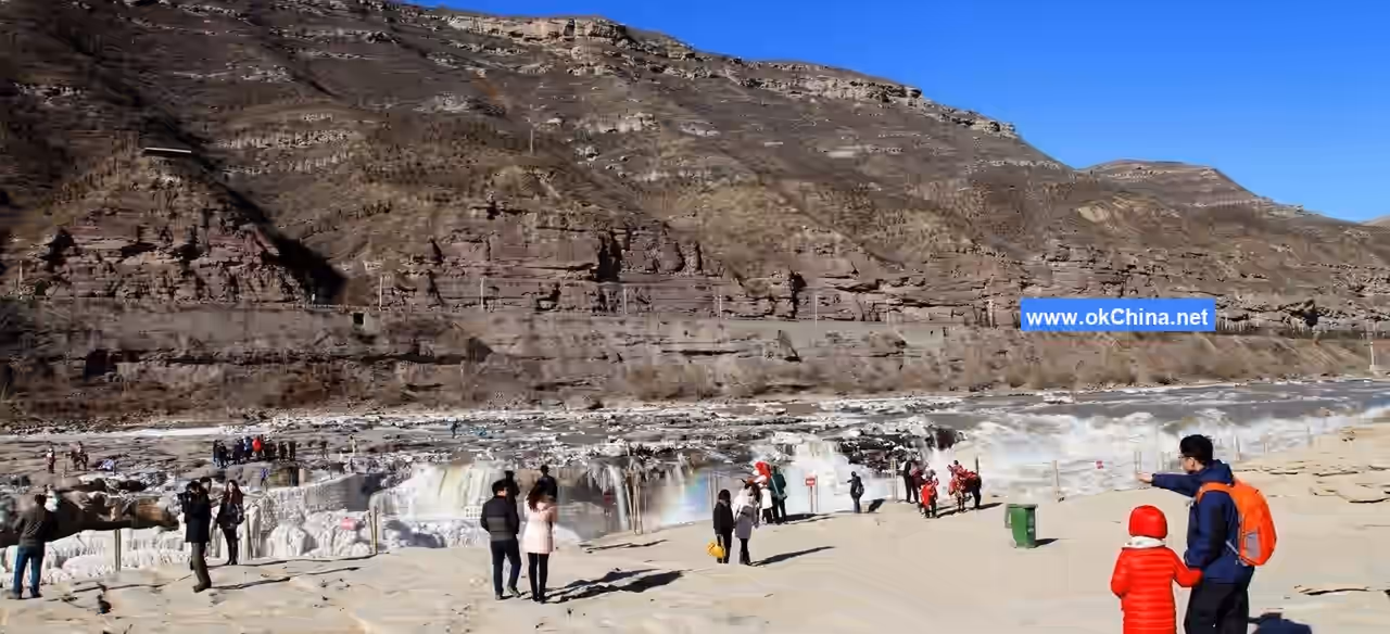
In the Hukou area, the west bank of the Yellow River is steep below and gentler above. The canyon floor is about 400 meters wide. From the canyon floor up to Longwangpo, the slope rises about 150 meters with very steep cliffs. Above Longwangpo, the canyon widens, and the slopes become gentle. The cross-section of the Yellow River here takes on a "valley within a valley" form. North of Longwangchan, the river width matches the canyon width, and the river fills the canyon. Under normal water levels, the flow ranges from 1,000 to 3,000 cubic meters per second, with a water surface over 400 meters wide. South of Longwangchan, the water flows to Hukou, where it has carved a deep channel (a small channel within the large river channel) into the flat canyon floor. This small channel is 30–50 meters wide and about 30 meters deep. Above Hukou, the water flows in the wide channel. At the upper end of the deep channel, the 400-meter-wide water surface suddenly pours entirely into the 30–50-meter-wide deep channel, forming the waterfall. Here, the riverbed resembles a huge teapot, collecting the surging waters of the Yellow River, hence the name "Hukou" (Teapot Spout). The Ming Dynasty poet Hui Shiyang's verse, "Originating from Kunlun, it flows mightily; through nine turns at Yuguan, it's gathered into one teapot," vividly depicts this scene. Hukou Waterfall is extremely spectacular: the torrential yellow water cascades down with surging currents, rolling muddy waves, splashing spray, misty haze, and roaring waves audible for miles. The waterfall height can reach 15–20 meters during the dry season and up to 45 meters during summer and autumn. During floods, the raging torrent overflows the deep channel, and the waterfall transforms into a rushing rapid, losing its distinct waterfall form. The river flows 5 kilometers downstream along the deep channel to Mengmen. Beyond Mengmen, the water surface widens, the current slows, and the scenery reverts to that seen above Longwangchan.
Geological Structure
The bedrock exposed in the Hukou area primarily belongs to the Triassic Zhifang Formation. The upper part consists of interbedded purple-red, purple-gray, and gray-green fine sandstones and argillaceous rocks. The lower part comprises thick-bedded sandstone, mainly feldspathic sandstone, which is relatively hard. The argillaceous rocks are mainly shale, which is soft, fragmented, and easily eroded by flowing water. In the steep canyon, the rushing torrent, while vertically downcutting, encounters alternating layers of hard and soft rock. The hard rock forms rock ledges or waterfall-forming layers, while the soft rock is eroded into steep steps. The rapid flow leaps over these steps, and when there is sufficient drop, a waterfall forms. Of course, the interbedded hard and soft rock layers merely provide favorable stratigraphic conditions for waterfall formation.
Favorable structural conditions are also crucial for the formation and development of Hukou Waterfall. From Hukou to Mengmen, the bedrock strata are nearly horizontal, dipping gently northwest at an angle of about 3–5 degrees. Additionally, the Qin-Jin Gorge itself is a fault zone with relatively developed joints, making it a weak area susceptible to erosion and incision by flowing water. Therefore, as the Yellow River flows through here, steep riverbed steps often form, which can develop into waterfalls.
Modern tectonic movements also significantly influence the formation and development of Hukou Waterfall. Since the Himalayan Orogeny, crustal movement here has been characterized mainly by slow uplift, promoting active downcutting by the river, which aids in the formation and development of the waterfall.
Stratigraphic Characteristics
The Hukou area belongs to the Shaanxi-Gansu-Ningxia Basin stratigraphic subregion of the North China Stratigraphic Region. The bedrock exposed in the Yellow River valley is the Middle Triassic Lower Zhifang Formation (T2Z). In some tributary gullies on the west bank of the Yellow River, the Middle Triassic Upper Tongchuan Formation (T2t) is occasionally exposed. The bedrock is overlain by Middle Pleistocene and Late Pleistocene loess (Q2+3). In order from oldest to youngest, the strata exposed in the Hukou area are as follows:
Middle Triassic Lower Series – Zhifang Formation (T2Z): Named after Zhifang Town in Tongchuan City. The lithology is primarily interbedded purple-red and purple-gray sandy mudstone. Coarser at the bottom and finer at the top, containing fossils of vertebrates, plants, ostracods, bivalves, conchostracans, etc. Thickness is several hundred meters, belonging to inland fluvial-lacustrine deposits.
Middle Triassic Upper Series – Tongchuan Formation (T2t): The base begins with massive medium to coarse-grained sandstone, grading upward to black and dark gray-green shale at the top. It coarsens upward from bottom to top, forming a complete cycle. The most complete section and richest fossil assemblage are found in Tongchuan, hence the name. Over 400 meters thick, also belonging to inland fluvial-lacustrine deposits. The contact between the Tongchuan Formation and the underlying Zhifang Formation is conformable.
Quaternary Middle Pleistocene Lishi Loess and Upper Pleistocene Malan Loess (Q2+3): The Middle Pleistocene Lishi Loess is light gray-yellow and pale red-gray loess, interbedded with varying thicknesses of reddish-brown paleosol layers. The base consists of sandy loam or sand layers, containing abundant vertebrate fossils. The Upper Pleistocene Malan Loess is aeolian dust deposit of light gray-yellow loess. The loess has a clear unconformable contact with the underlying bedrock.
Tectonic Setting and Evolution
Hukou Waterfall is located in the southeastern part of the Northern Shaanxi Loess Plateau within the central Ordos Basin. Tectonically, it belongs to the Ordos Platform Depression, a second-order tectonic unit of the Sino-Korean Paraplatform. Its basement is composed of Archean and Early Proterozoic metamorphic rock series. The cover consists of extensively developed sedimentary rock series from the Late Proterozoic onwards, with a clear angular unconformity between the cover and the basement. The formation of the platform basement underwent a complex and lengthy evolutionary process. Within the Ordos Platform Depression, the basement is rarely exposed due to the thick overlying Paleozoic, Mesozoic, and Cenozoic strata.
During the Late Proterozoic, although this platform had entered its platform development stage, it still exhibited some activity. At that time, differential uplift and subsidence within the platform were relatively pronounced, accompanied by faulting. The vast central area of the platform was dominated by uplift, while narrow, elongated belts of depression and uplift appeared along the margins. The sediments deposited within the depression belts became the platform's first cover layer. During the Sinian Period, most of the platform had risen above sea level and was subjected to continuous weathering and denudation.
The Mesozoic Era was a period of major development for the Ordos Basin, with extensive inland fluvial-lacustrine sedimentation, exhibiting quite stable lithofacies and thicknesses. Crustal movement was dominated by overall uplift and subsidence. Only during the Yanshanian Movement at the end of the Jurassic and the end of the Early Cretaceous did the platform cover experience gentle folding, forming broad, gentle synclines. In the late Early Cretaceous, the basin began differential uplift, with the southeastern part rising higher and undergoing erosion, while the northwestern part relatively subsided, becoming a depositional center. At that time, the land surface sloped from southeast to northwest, opposite to the present-day orientation. Since the end of the Cretaceous, the entire region has been slowly rising. By the Miocene, the surface was denuded and planated into a peneplain. Consequently, the Paleocene and Eocene series are generally absent within the basin. At the end of the Miocene or the beginning of the Pliocene, due to tectonic movements, this peneplain experienced uplift in the north and subsidence in the south. The overall regional topography shifted to being higher in the northwest and lower in the southeast, with the general ground inclination direction consistent with the modern one.The tectonic movements in the Ordos Basin during the Quaternary period are characterized by differential and rhythmic uplift. From the Pleistocene to the Holocene, the crust underwent a developmental process from rhythmic uplift to more intense uplift. Consequently, on the basis of the pre-Quaternary paleogeomorphology, erosion and sedimentation occurred to varying degrees. The loess deposits and fluvial-lacustrine sediments formed in the same area during different periods, as well as in different areas during the same period, constitute the main components of the Quaternary system in this region. Particularly, the Middle Pleistocene loess, which is widely distributed and thick, forms the main material of the plateaus, ridges, and hills. The loess landforms in this area evolved precisely on this foundation.
The formation of the Yellow River spanned a long geological period. Before the Quaternary, the basin's topography was largely similar to the modern one, but a unified Yellow River had not yet formed. By the Early and Middle Pleistocene of the Quaternary, the main lake basins within the basin included Gonghe, Yinchuan, Hetao, Fenwei (Sanmen Lake), and North China. Except for the North China Lake, which was once connected to the ocean, these lake basins were inland types, each forming an independent water collection system. Due to the headward erosion and extension of rivers between the lakes, the lake basins became interconnected, though the sequence of connections varied. Ultimately, by the end of the Late Pleistocene to the early Holocene, a unified Yellow River was formed. Therefore, the thousand-mile-long Qin-Jin Gorge and the Hukou Waterfall gradually formed during the process of the Yellow River's formation.
Topography and Geomorphology
Before the Yellow River formed a unified water system, most of the Qin-Jin Gorge area was an inland river flowing into Sanmen Lake. During the formation of the Fenwei Graben, differential subsidence in different areas and periods led to the formation of a series of lakes of varying sizes and depths, separated from each other. Areas such as Linfen, Yuncheng, and the Guanzhong region were primarily lake and swamp environments from the Tertiary to the early Quaternary. Particularly by the end of the Pliocene, with the formation of the Fenwei Graben rift system, the lakes grew larger. During the Early Pleistocene, in the area where present-day Shaanxi, Shanxi, and Henan provinces meet, including the Guanzhong region of Shaanxi, southwestern Shanxi, and western Henan, a lake covering approximately 23,000 square kilometers formed—Sanmen Lake. This ancient lake was the precursor to the Guanzhong, Linfen-Yuncheng, and Lingbao-Sanmenxia basins. The subsidence of the Sanmenxia Lake area and the uplift of the surrounding regions accelerated the deepening and extension of the ancient Qin-Jin river channel. The Qin-Jin Gorge and Hukou Waterfall gradually formed on this ancient geomorphological foundation.
The formation and development of Hukou Waterfall are the result of the development and migration of knickpoints on the riverbed. A knickpoint is a sudden steep section in a river. The most typical knickpoint is a waterfall, as it is where water falls vertically. Therefore, a waterfall must have a "waterfall-forming layer" of hard rock to resist erosion and prevent the waterfall from turning into rapids. Below the waterfall, there is a deep pool formed by the falling water. If the waterfall-forming layer erodes and retreats, a short gorge forms in front of the waterfall, indicating the continuous retreat of the waterfall. This is precisely the topography of Hukou Waterfall. Mengmen was once the past location of Hukou Waterfall. Due to headward erosion, the knickpoint continuously migrated upstream along the river, and the deep pool below the waterfall extended into a small channel within the original riverbed—known as the "Ten-Mile Dragon Trough." Today, the knickpoint of this section of the Yellow River has reached Longwangchan, which is the current Hukou Waterfall, while Mengmen consists of two stone islands left on the riverbed during the recent geological period of knickpoint retreat and river incision.
Hukou Waterfall, the Ten-Mile Dragon Trough, and even the Mengmen Stone Islands were all carved out by the flow of the Yellow River. The erosive action of the water is controlled by regional geological structures, geomorphology, climate, hydrology, and other physical geographical factors. Due to the combined influence of various natural conditions in different periods, the rate of headward migration of Hukou Waterfall and the extension of the "Dragon Trough" have varied. Over the years, the waterfall has retreated upstream at a rate of 3–4 centimeters per year, and the Dragon Trough has extended upstream at the same rate.
Geomorphological Features
Yichuan County in Shaanxi and Jixian County in Shanxi are both located in the Loess Plateau region. The geomorphological type here is primarily fragmented loess plateaus, with only narrow strips on both sides of the Yellow River valley forming rocky hills covered by thin layers of loess.
The fragmented plateaus in Yichuan are mainly distributed on both sides of the Yunyan River and within the Shiwang River basin. The plateau surfaces are at elevations of 1,000–1,400 meters, gently sloping from west to east. The once-intact plateau surfaces have been disrupted, divided into smaller plateau fragments by gullies. Among these, the Niujiadian Plateau, Gelou Plateau, and Gaobai Plateau are relatively large, facing the fragmented loess plateaus of Jixian County in Shanxi across the Yellow River. The underlying bedrock paleogeomorphology of these fragmented plateaus is an intermontane basin later traversed by the main stream of the Yellow River. The Pliocene red clay and Early Pleistocene loess have mostly been eroded, while the thick Middle Pleistocene loess laid the foundation for the loess plateaus. Later, Late Pleistocene Malan loess accumulated, and under the influence of inherited river gullies and modern erosion gullies, these gradually became fragmented loess plateaus. The plateau surfaces are not only fragmented but also exhibit relative height differences of 100–120 meters from the edge of the gullies to the center of the plateaus. For example, the Niujiadian Plateau is several kilometers wide from east to west and tens of kilometers long from north to south, transitioning in a gently sloping step-like manner to the main gullies. The slope increases from 1–3 degrees at the center of the plateau to 10–15 degrees at the edges. Since all rivers in the plateau area converge into the Yellow River, which has a very low base level, various erosion processes are relatively active.
The narrow, belt-like areas along both banks of the Yellow River are rocky hills covered by thin layers of loess. The bedrock exposed around Hukou is mainly Triassic sandstone and shale, overlain by thin, discontinuous loess layers with thicknesses varying from 0 to 40 meters. The hilltops appear as ridges and hills, with elevations generally around 1,200 meters above sea level, similar to the elevations of the surrounding fragmented plateaus and 400–500 meters higher than the Yellow River valley floor. Due to the proximity to the Yellow River Gorge and the intense downcutting of the Yellow River, the tributaries along its banks have also undergone strong downcutting, fragmenting the land surface along the banks and forming rocky hills covered with thin loess layers. Ridges and hills undulate, and gullies are deeply incised. Except for the exposed bedrock at the lower parts of ridges and hills, in some areas, the overlying loess has been eroded, exposing the bedrock directly and presenting a landscape of bedrock remnants.
Qin-Jin Gorge
After flowing out of the western Loess Plateau, the Yellow River follows the fault basins along the western and northern edges of the Ordos Plateau, running from south to north before turning eastward in a sharp right angle. Blocked by the Lüliang Mountains, it suddenly turns south at Hekou Town south of Tuoketuo in Inner Mongolia. Roughly south of Lamawan in Qingshuihe County, it enters the eastern part of the Loess Plateau. The Yellow River flows swiftly southward, separating the Shaanxi and Shanxi Loess Plateaus. Near Tongguan, blocked by the Qinling Mountains and pushed by the flow of the Wei River, the Yellow River turns eastward, cutting through the mountains between Shaanxi, Shanxi, and Henan, exiting at Taohuayu, and entering the North China Plain. From Lamawan to Longmen, the river stretches over 700 kilometers. Except for a few sections with wider valleys, most of the banks feature steep cliffs rising tens to over a hundred meters above the water surface. The river channel is generally 200–400 meters wide, making it the most magnificent long gorge on the main stream of the Yellow River. The section from Hequ County to Longmen, spanning 500 kilometers, is known as the Qin-Jin Gorge, often called the "Thousand-Mile Long Gorge." The gorge shows little variation along its course. The river maintains a north-south flow direction, roughly parallel to the strike of the Paleozoic and Mesozoic strata along the banks. From Fugu south to Hukou Waterfall, the river cuts through Triassic sandstone and shale, with steep cliffs on both banks and a width of about 300–400 meters. Longmen marks the end of the Qin-Jin Gorge, with a valley floor width of about 150 meters and exposed strata mainly consisting of Ordovician limestone and Carboniferous-Permian sandstone and shale. Mountain ranges stretch along both banks, generally extending northeast-southwest, forming a barrier for the Fen and Wei plains. After exiting Longmen, the riverbed suddenly widens.
The Qin-Jin Gorge had already taken shape before the Pliocene. The present Yellow River largely follows an ancient river valley developed on the Tangxian erosion surface and has cut down into it. The main reason for the Yellow River's downcutting was the faulting and uplift of the Shanxi Platform in the late Pliocene, which caused a normal fault at Longmen Mountain in Yukou. The northern block rose while the southern block subsided, leading the Yellow River to cut into the bedrock and form the magnificent gorge. During the process of intermittent uplift and downcutting, five distinct bedrock terraces formed within the gorge. Between Wubao and Yukou, the highest bedrock terrace has a relative height of 230–250 meters, while the other four have relative heights of 160–205 meters, 75–95 meters, 25–35 meters, and 8–12 meters, respectively. The formation of these five terraces cannot be solely attributed to crustal uplift; at least the lowest terrace resulted from increased river downcutting due to a wetter climate and increased flow after loess deposition in the late Pleistocene.
IV. Important Scenic Areas
Eight Wonders of the Waterfall
Smoke Rising from the Riverbed
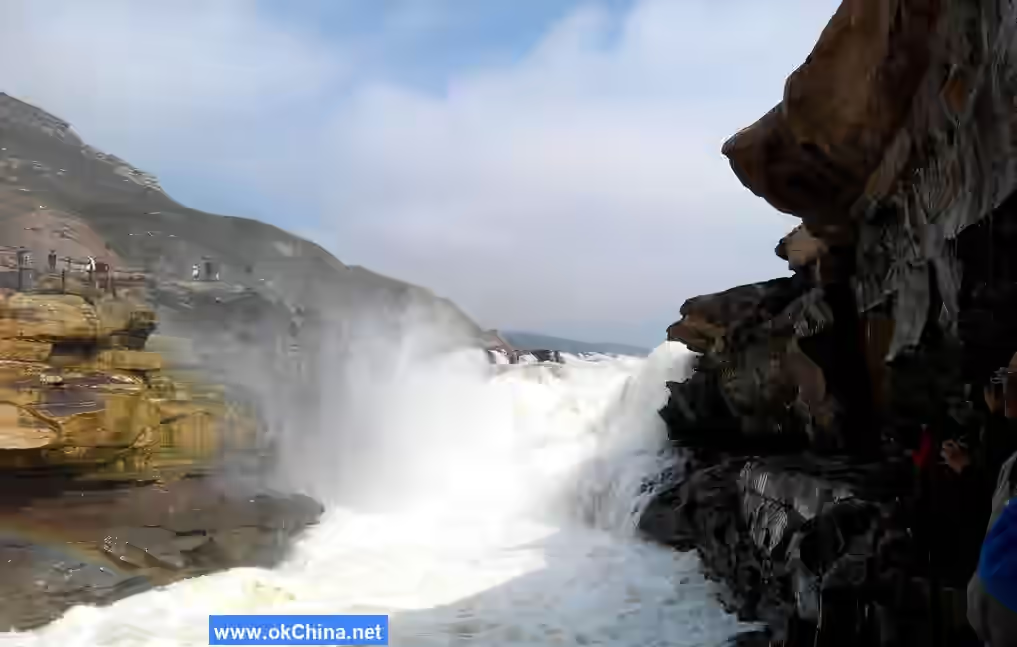
At the point where the Yellow River enters the "Hukou," the turbulent flow rushes down, churning up mist that rises into the sky, connecting with the clouds like billowing smoke emerging from the riverbed, visible from over ten miles away.
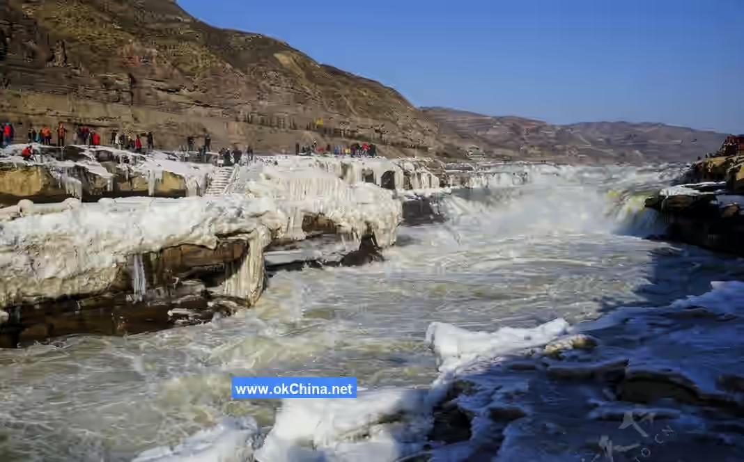
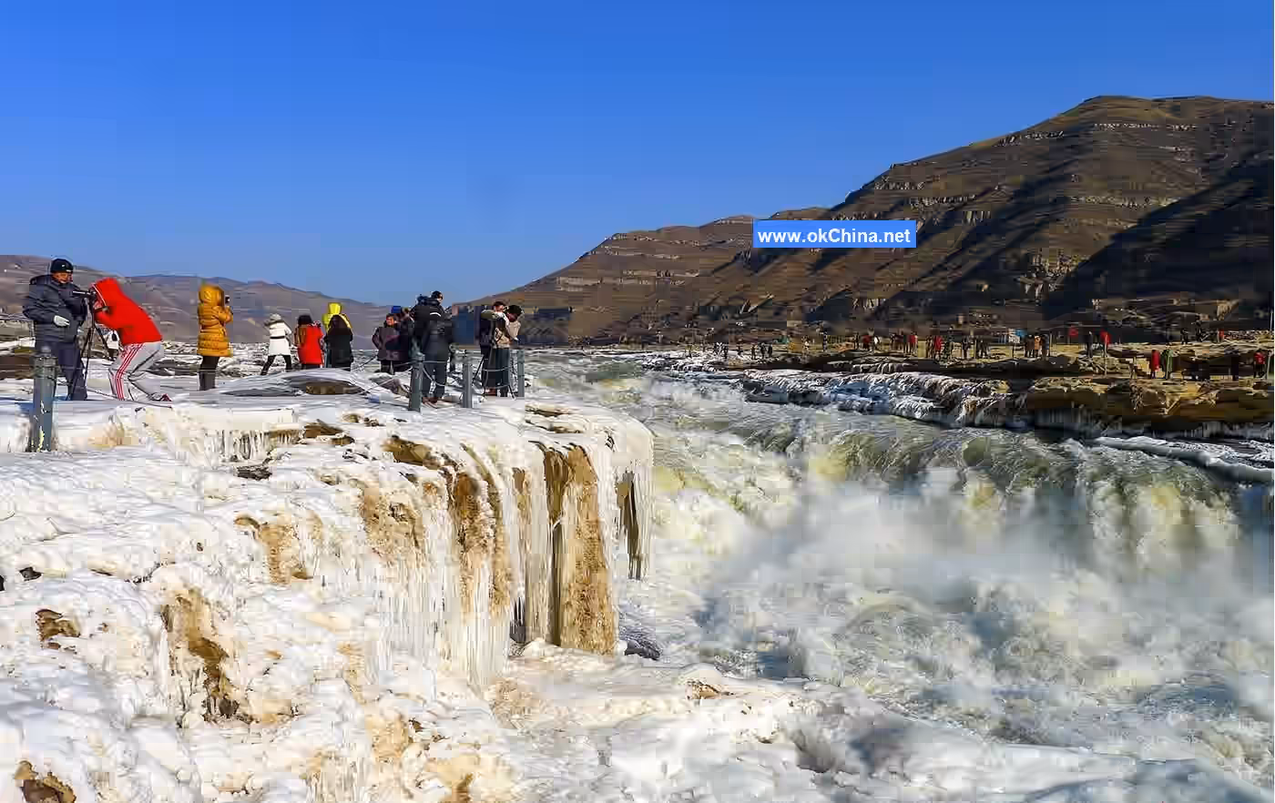
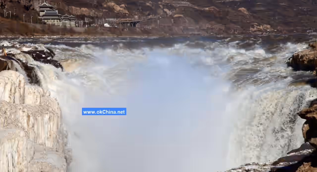
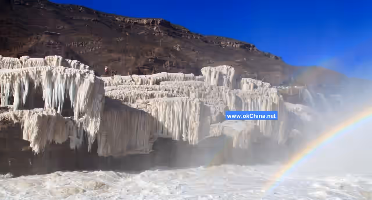
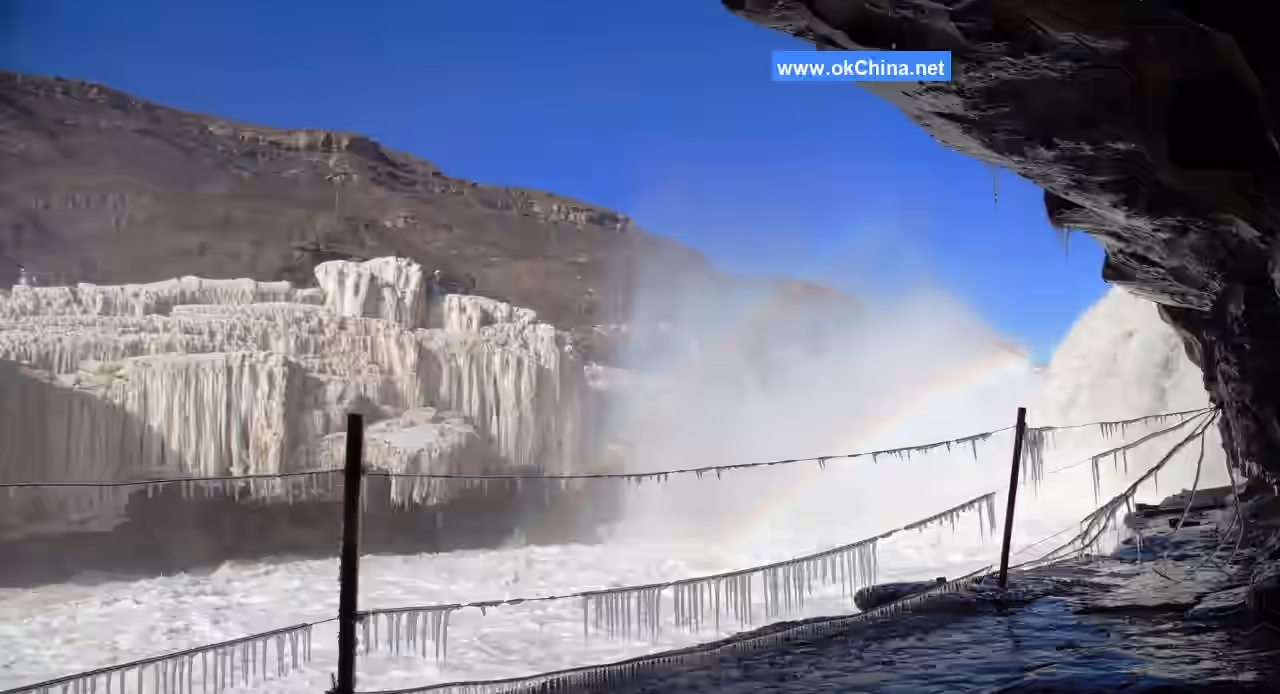
The amount of mist at Hukou is related to the season and flow rate. In winter, when the river surface freezes, the waterfall often turns into ice, surface runoff decreases, and the flow at Hukou drops to 150–500 cubic meters per second. The falling water creates little splash, and minimal mist rises above the channel. In summer, when the flow increases significantly, water overflows the deep channel, the drop height becomes very small, the waterfall disappears, and dense mist rising high into the air is less likely to form. In spring and autumn, with moderate flow and lower temperatures, the waterfall drop exceeds 20 meters, and the rushing water creates a dense mist in the air, forming the spectacle known as "Smoke Rising from the Riverbed."
Land SailingThe Hukou Waterfall has a significant drop, and the deep, narrow, and long channel beneath it, combined with the turbulent flow, makes navigation extremely difficult for watercraft. Boats traveling downstream from upstream of Hukou had to dock at Longwangchan above the waterfall, unload all cargo, and transport it along the riverbank to downstream docks using human porters and pack animals. Meanwhile, the empty boats were hauled out of the water by manpower, placed on round wooden rollers, and dragged along the riverbank. Once they reached the calmer waters downstream of Hukou, the boats were relaunched, reloaded with cargo, and continued their journey. Dragging the boats on land required immense effort, often involving hundreds of people pulling with all their might. Despite the use of round wooden rollers beneath the boats, the iron nails on the boat bottoms still scraped numerous marks into the rocky riverbank. Under the conditions of the time, "land sailing" was likely the best option for water transport to bypass the Hukou Waterfall, suited to the relatively gentle rocky banks above and below the falls. Due to the rapid expansion of roads and railways, as well as the construction of the Yellow River Bridge near Hukou, water transport across Hukou has been blocked for many years. Today, only traces of the past land sailing remain visible.
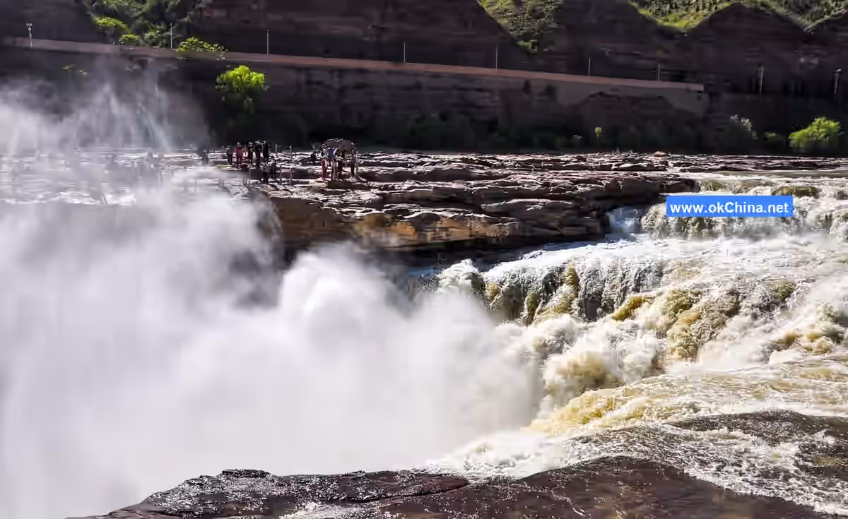
Rainbow Playing in the Water
The mist formed by the repeated impact of the Hukou Waterfall rises into the air, refracting sunlight to create rainbows. Sometimes the rainbow arcs from the sky into the water, resembling a dragon drinking; other times it appears as a straight, colorful band across the water, like a flying rainbow bridge. Occasionally, amidst the dense mist, clusters of colorful, shimmering light appear, elusive and mesmerizing, making it a wonder of the world.
Rainbow playing in the water is the result of the combined effects of "smoke rising from the water" and sunlight. In spring and autumn, when smoke rises from the water and thick mist hangs high, rainbows often form on sunny days with slanting sunlight. After summer rains clear, rainbows may also appear.
Mountains Flying and Seas Standing
"Mountains flying and seas standing" describes the majestic momentum of the Hukou Waterfall. The Yellow River surges through the thousand-mile-long gorge, its turbulent currents rushing toward Hukou, suddenly converging into a narrow channel to form an extraordinarily spectacular waterfall. Looking up at the curtain of water, the rolling yellow torrent pours down from the horizon with the force of a thousand mountains collapsing and seas overturning, constituting the core landscape of Hukou Waterfall.
Rain from a Clear Sky
The flying waterfall creates a mist that floats and rises into the air. Even under the blazing sun, near the waterfall, it feels like a drizzling rain, dampening clothes. This is another fascinating spectacle produced by the "smoke rising from the water." Generally, the closer to the river surface, the denser the mist. Thus, when smoke rises from the water, visitors on the shore are inevitably drenched as if lightly washed.
Thunder in Dry Weather
As the Yellow River flows through the gorge, its raging waves resemble a mighty army, galloping and roaring, shaking the valley. When the waterfall plunges down, repeatedly striking the rocks and water surface, it produces tremendous sounds that echo through the mountains, like ten thousand drums beating or thunder in dry weather, audible from dozens of miles away. Only near the Hukou Waterfall can one truly feel "the Yellow River roaring" and "the Yellow River raging."
Hanging Ice Peaks
In the depths of winter, the Longcao channel freezes over, and the water columns formed by the overflow along the banks hang like ice peaks of varying sizes from the cliffs. Rainbows appear and disappear intermittently, drifting among them. The interplay of seven colors and crystalline ice leaves every visitor marveling at the wonders of nature.
Ten-Mile Dragon Trough
From Hukou to Mengmen is about 5 kilometers. At the bottom of this box-shaped gorge, over 400 meters wide, the Yellow River has cut down to form a trough 30–50 meters wide and 10–20 meters deep. After rushing down from Hukou, the Yellow River converges into this trough with a massive flow of thousands of cubic meters per second. Legend has it that it was carved by a dragon, and as it is about 10 li (approximately 5 kilometers) long, it is named the "Ten-Mile Dragon Trough," also known as the "Ten-Mile Dragon Moat." It was formed as the Hukou Waterfall eroded upstream, continuously extending the deep pool below. This deep trough is embedded in the bedrock riverbed of the original valley floor, with most of the adjacent original riverbed becoming the riverbank during non-flood seasons. This type of riverbank is relatively wide and flat, entirely composed of hard sandstone. Near the water, there is almost no sand or gravel, and it is flat enough to drive vehicles on. "Land sailing" precisely utilized these geological and topographical conditions.
From the higher riverbanks, the "Dragon Trough" and the Yellow River flow are almost invisible. Only a line of turbulent, yellow, muddy water churning in the purplish-brown bedrock riverbed can be seen, accompanied by the ceaseless roar of rushing waves. The torrent in the trough resembles a pot of boiling water, surging left and right, tumbling and rushing downstream. The mist it stirs up envelops the Dragon Trough, making the Yellow River here appear hazy and朦胧. During flood seasons when the Yellow River rises, the floodwaters overflow one end of the Hukou Dragon Trough, creating a spectacular curtain of flowing water, one to two kilometers long, on the eastern bank of the Dragon Trough. From a distance, the winding stone trough in the gorge looks like a dragon shaking its head and tail, with Hukou as the head, swallowing the massive flow of the Yellow River, and Mengmen as the tail, discharging the river water downstream.
Scenic Spots and Landscapes
Mengmen Mountain
About five kilometers downstream from the Hukou Waterfall, below the "Ten-Mile Dragon Trough," two spindle-shaped giant rocks stand majestically in the torrent on the riverbed of the Yellow River valley, forming two river-islands. These are the Mengmen Mountains, historically known as the "Stepping Stones of the Nine Rivers." Legend has it that these two islands were originally one mountain blocking the river, causing floods to overflow. When Yu the Great controlled the floods, he split the mountain in two to guide the water flow smoothly. Viewed from afar, these islands resemble boats; up close, they look like mountains; from above, they appear as gates. Another legend says that descendants of the Meng brothers, once swept away by the river, were rescued here, hence the name Mengmen Mountain.
The larger Mengmen Island is about 300 meters long, 50 meters wide, and rises about 10 meters above the water. On the southern cliff face, there is an inscription from the early Yongzheng period of the Qing Dynasty by Xu Huanying, the prefect of Jinming County, reading "Lying to Calm the Raging Flow." The plaque is 2.5 meters long and 1 meter wide, a true depiction of the extraordinary landscape here. The smaller Mengmen Island is located about 10 meters upstream of the larger one, only 50–60 meters long. Both river-islands are composed of horizontally bedded, massive gray-green sandstone, which is hard and highly resistant to weathering.
Mengmen stands tall against the汹涌奔腾的泥流, enduring towering waves year-round without being submerged. "To the south, it connects with the ancient spirit of Longmen; to the north, it links with a thread of sky from Hukou." Its majestic posture, together with Longmen and Hukou, forms the three wonders of the Yellow River, yet it is renowned for its unique风貌. An ancient poem praises it: "In all seasons, mist and rain迷蒙 Hukou; on both banks, waves撼动 Mengmen."
Historical documents contain many records of Mengmen, and local folklore offers even more tales. According to Geographical Knowledge, Mengmen was originally a knickpoint on the Yellow River bed, where the Hukou Waterfall once appeared. Over time, due to crustal uplift and enhanced river downcutting, headward erosion shifted the knickpoint upstream, moving the waterfall to its current location. The deep pool below the waterfall developed into the "Ten-Mile Dragon Trough," while Mengmen Mountain is the remnant rock mass left behind as the waterfall's deep pool migrated.
Although Mengmen Mountain can hardly be called a "mountain," its奇特景致 is captivating. Qing Dynasty poet Nan Peng wrote in a poem: "I heard Mengmen was small, but seeing it, it's like a fist. Naturally formed as a desk scene, it seems suspended in a painting."
The Mengmen area of the Yellow River is not only迷人风光, with the beauty of "Moonlit Night at Mengmen," but also holds significant scientific value in studying the developmental history of the Yellow River.
West Longzhang Plateau
The West Longzhang Plateau stretches north from Taoqu to south to north of Gancao, bounded east by the cliffs of the Qin-Jin Gorge and west by the area beyond Anle Mountain. Its landscape features typical Loess Plateau scenery and plateau village views, with vast, open fields on the plateau.
Mangtou Mountain
Mangtou Mountain National Forest Park is located in the eastern part of Yichuan County, Yan'an City, Shaanxi Province, with elevations ranging from 800 to 1,439 meters. It covers a total area of 2,120 hectares, with a forest coverage rate of 89.1%. It is divided into three scenic areas: Our Lady's Hall, Shihua Mountain, and Wangmang Village, featuring over thirty scenic spots. The park has dense forests, primarily mixed coniferous and broad-leaved forests dominated by lacebark pine, oriental arborvitae, and Liaodong oak, with over 400 species of higher plants, including more than 100 woody species. It hosts China's largest secondary forest of lacebark pine.
Natural History
The Loess Plateau, the Yellow River channel, the Qin-Jin Gorge, as well as the Hukou Waterfall, the Ten-Mile Dragon Trough, and Mengmen Mountain, are all products of nature and important natural historical relics. In addition, the following natural historical relics exist near Hukou:
High Terraces of the Yellow River
On rock surfaces 100 meters above the riverbed, there are accumulations of gravel layers 1–2 meters thick, which together constitute a high terrace of the Yellow River. This accumulation terrace is a product of the early developmental stage of the Yellow River, representing remnants of the riverbed from that time. Such high terraces also exist in some sections of the Qin-Jin Gorge. They hold significant importance for studying the developmental history of the Yellow River and the characteristics of crustal movements during that period.
Fossil Site of Dipoides
About 3 kilometers downstream from the Hukou Waterfall, fossils of Dipoides (a type of rodent) have been discovered, distributed over an area of approximately 40 square meters. Dipoides lived millions of years ago. The discovery of this paleontological fossil site is of great significance for studying the ancient geographical environment around Hukou.
Minor Loess Landforms
Loess plateaus, hills, ridges, and the gullies between them are large-scale loess landforms. However, minor loess landforms such as loess pillars, loess sinkholes, loess bridges, loess walls, and loess caves appear at the edges of loess cliffs. Around Hukou, along the fragmented edges of the loess plateaus on both banks of the Yellow River, such minor loess landforms are widely distributed.
On the cliff north of the Shiwang River valley, about 15 kilometers from the county river estuary, there is a natural bridge. The bridge is 6–7 meters long, 1.5–3 meters wide, with a flat top, projecting悬挑 into the air, appearing quite奇险.
About 10 kilometers east of Yichuan County, on the southern bank of the river near Jingyang Village, on the mountainside of Heishanling, there is a stone cave called Baiyun Cave (White Cloud Cave). The entrance is square, allowing only one person to crawl through. Inside, it suddenly widens, enabling standing and walking. There is a stone resembling a pagoda-shaped stalactite, 2–3 meters high, smooth and lovely.
Rare Plant – Purple-Spotted Dwarf PeonyYichuan was anciently known as Danzhou, a name said to derive from its abundant peonies.
According to old county records: "Thirty li east of the county seat, on the eastern hill of Xingji Town (now the site of Qiulin Township government), there is a place called Peony Plateau. In the past, it was rich in peonies, which bloomed profusely in the wild during summer and autumn. The flowers covered the hills, their fragrance wafting for dozens of li. Unfortunately, no one cultivated them, and locals gathered them for firewood." This refers to a wild peony species, the Purple-Spotted Dwarf Peony, a wild variant. Once widely distributed across northern Shaanxi, large contiguous patches are now rare, making it a precious plant species in need of protection.
As early as the Tang and Song dynasties, Yichuan was not only one of the four major famous peony-producing areas, but its 'Danzhou Yellow' peony variety was already transplanted as a prized cultivar to Luoyang in Henan. Among Luoyang's earliest eight peony gardens, the first was the "Danzhou Garden." The renowned Song dynasty literary figure Ouyang Xiu, in his Record of the Luoyang Peonies, described: "Peonies come from Danzhou," and "Danzhou Yellow, a thousand-petaled yellow flower."
The Danzhou peony sprouts leaves from its stems in the second lunar month, and by the third month, its shoots resemble those of a kiwi plant, bearing round, green fruit in autumn. The produced peony root bark (Danpi) is thick and fleshy, presenting a reddish-brown color. Li Shizhen praised it in the Compendium of Materia Medica: "The root bark of the Danzhou peony is especially excellent for medicinal use."
Due to long-term firewood gathering and human destruction, the once contiguous wild peonies are now sporadically distributed on some ridges, their numbers few.
IV. Cultural Resources
Human History
Ancient Ferries and Market Towns
Among the ancient ferries and market towns, the larger ones were Donglongwangchan on the east bank and Gezhentan on the west bank. Additionally, ferries like Yijindu, Xiaohekou, and Guantoudu on the west bank faced Fengjiaqi, Mafentan, and Hamatan respectively on the east bank. The reason numerous ferries formed above and below Hukou is that the Hukou Waterfall posed a natural obstacle to water transport on the Yellow River, dividing the waterway into two sections. Boats traveling to and fro would dock at a ferry before reaching Hukou to unload cargo. They would then be hauled overland past the waterfall—a practice called "dry-land boat hauling"—before being reloaded onto boats at another ferry downstream to continue their water journey. Furthermore, frequent economic exchanges between Qin (Shaanxi) and Jin (Shanxi), coupled with the convenience of ice bridges in winter, led to the emergence of these ferries. At that time, these ferries served as distribution centers for waterborne goods moving north, south, east, and west in the middle reaches of the Yellow River. The Yellow River water transport through the Qin-Jin Gorge played a positive role in the economic development of regions like Inner Mongolia and the Central Plains, as well as Shaanxi and Shanxi.
Before the completion of the Beijing-Baotou Railway, Yellow River shipping was highly developed. Donglongwangchan was an important water-land port and a relatively prosperous commercial town along this section of the river. At that time, shipping would commence with the spring peach-flood season each March. Except for interruptions during periods of exceptionally heavy flood peaks in the rainy season, cargo boats sailed downstream continuously until the river began freezing over around the Minor Snow and Major Snow solar terms. People from the upper reaches, for the purpose of material exchange, would fell trees and build boats every winter. In spring, they would load these boats with local products such as licorice root, red dates, grain, hides, animal bones, coal, porcelain, salt, and soda ash, transport them past Hukou to areas like Fenglingdu and Mengjin downstream, and sell both the boats and cargo. They would then return home on foot, empty-handed. Aside from a few official vessels, most of these boats were merchant ships. In terms of grain capacity, large boats could carry over 9,000 kilograms, while smaller ones held around 6,000 kilograms. In normal years, four to five thousand boats passed through the port. At its peak, Donglongwangchan hosted over 1,000 moored boats, with several hundred people working as haulers for the "dry-land boat hauling." According to various stele inscriptions preserved at Donglongwangchan, this town flourished from the early Ming dynasty, prospered during the Qing dynasty—especially reaching its peak from the Qianlong to Daoguang reigns—and declined before the War of Resistance Against Japan, spanning approximately 400 years in total. An inscription from the ninth year of the Tongzhi reign (1870), recording the repair of temples burned by the Nian Army crossing eastward, notes that 63 merchant houses contributed funds for the temple restoration, including money shops, fur shops, pawnshops, salt shops, medicine shops, and shops selling goods from the capital, indicating considerable economic activity.
The economic activity at Donglongwangchan port required not only corresponding commercial institutions but also a sizable shipping organization to expedite the "dry-land boat hauling." Consequently, in the early years of the Kangxi reign of the Qing dynasty, a civilian porterage organization called "Liugutou" (Six Shares) emerged. This organization was primarily composed of six large villages near Hukou in Ji County: Nanyuan, Shangshi, Zhongshi, Liucun, Nancun, and Guxian. It was responsible for assigning porterage tasks, organizing manpower, and distributing remuneration and taxes. This organization lasted until the 20th year of the Republic of China (1931). Over its 200-year activity, it played a positive role in promoting local economic prosperity and cultural exchange.
Additionally, places like Yijindu, Fengjiaqi, Gezhentan, and Xiaochuanwo were historically famous ferry crossings and shipping ports. Mountain villagers, military troops, and merchants often traveled back and forth via these points. For instance, the ancient ferry at Gezhentan still retains a relatively complete appearance of an old market town, with stone mooring holes on the bank and mountain paths carved by boatmen on the stone cliffs remaining as they were.
At Donglongwangchan and Gezhentan, hundreds of Ming dynasty cave dwellings, complete courtyards, and ancient streets paved with stone slabs are also preserved.
After the completion of the Beijing-Baotou Railway, goods from Inner Mongolia were generally shipped from Baotou, and the Yellow River waterway through the Qin-Jin Gorge fell into disuse. Following the construction of the Yellow River Bridge, highways extended in all directions, rendering the ferries and ports near Hukou obsolete.
Military Relics from Various Dynasties
"At the border dividing Qin and Jin, ancient fortresses abound with historic significance." The Yellow River gorge section from Hukou to Longmen, with steep cliffs on both banks and the natural moat of the river in between, formed a natural barrier between Qin and Jin, making it a strategically contested location throughout history. To secure the frontier, successive dynasties established military-administrative institutions such as "Zongguanfu," "Cimasu," "Sihousi," and "Xunjiansi" along the route. During the Qing dynasty, a long wall was even built on the east bank of the Yellow River to prevent the Western Nian Army from crossing.
According to records, major military activities that occurred in the Hukou area throughout history include:
- During the Spring and Autumn period, the State of Jin, aiming to conquer the Guanzhong Plain, fought two major battles against the Di people from the Huanglong Mountains west of the river at Caisang (near present-day Xiaochuanwo by Hukou).
- In the Eastern Jin period, the Qiang chieftain Yao Xiang built Yao Xiang City (on present-day Nancunpo on the east bank) along the Yellow River, awaiting an opportunity to invade Guanzhong.
- In the late Northern and Southern Dynasties, Yao Xiang City served as a beachhead for Northern Zhou, blocking Northern Qi from crossing the Yellow River westward.
- In the 13th year of the Kaihuang era of Sui (617 AD), Duke Li Yuan of Tang led his army to Hukou, where "the people along the river offered boats, numbering over a hundred daily," and subsequently captured Chang'an.
- In the late Southern Song, Mongol forces took Fangzhou, crossed the Huanglong Mountains, forded the Yellow River at Gezhentan, and seized Xizhou from the Jin.
- In the 28th year of the Zhizheng era of Yuan (1368), remnants of the Yuan forces, after Emperor Huizong (Shundi) retreated from Beijing, carved stone holes and erected posts on both sides of the Hukou Longcao gorge to construct an iron-chain bridge, called the "Flying Bridge over the Yellow River," the remnants of which still exist.
- In the 3rd year of the Chongzhen era of Ming (1630), Li Zicheng's rebel army crossed the "ice bridge" in the Hukou area when the Yellow River froze and captured Ji County in Shanxi.
- In the late Qing, the Western Nian Army, operating in northern Shaanxi, was led by Prince Liang Zhang Zongyu in the 5th year of the Tongzhi reign (1866) to force a crossing of the Yellow River ice bridge at Xilongwangchan, cross the Lüliang Mountains, and reinforce the Eastern Nian Army.
- During the War of Resistance Against Japan (1937–1945), under Japanese pressure, Yan Xishan retreated with his remaining forces from Taiyuan, Shanxi, in the 27th year of the Republic of China (1938) to Nancunpo on the east bank of Hukou, Sangbai Village on the west bank, and the Qiulin area of Yichuan. An iron-chain bridge for troop crossing was also erected at the site of the former iron-chain bridge.
The main surviving military sites include:
- The Qing Dynasty Long Wall. Built between the 5th and 11th years of the Tongzhi reign (1866–1872), the Qing government deployed the Huai Army to construct a long wall on the east bank of the Yellow River to intercept the Western Nian Army from crossing eastward and ensure the safety of Beijing and Tianjin. The wall stretched from Pingduguan in the north to Yukou in the south, spanning 75 kilometers. Its outer wall was over 10 meters high, with a top width of 5 meters, equipped with gun platforms, battlements, passageways, and fort gates. Donglongwangchan served as the central command post, housing command organs below the level of Provincial Military Commander (Tidu) and garrisoning 3,500 troops.
- Nancunpo and Mafentan. Nancunpo is located 5 kilometers upstream from Hukou on the east bank. Mafentan lies below Nancunpo. During the War of Resistance Against Japan, this was the location of the Nationalist Second War Zone headquarters and the Shanxi Provincial Government, garrisoned for over five years. Remaining structures include large stone buildings like the "Zhonglie Temple" and "Leqian Hall," well-preserved stone cave-dwelling complexes, the Wanghe Pavilion, and hundreds of earthen cave dwellings used by the stationed troops. At the time, over 20,000 people were stationed here.
- Shibao Stronghold. Located at the mouth of the Yunyan River upstream from Hukou, it is exposed on three sides, with sheer cliffs on the east side overlooking the Yellow River. It is said to have been built during the Song-Jin period. The Western Nian Army once used it to confront Qing forces. Remaining features include the stronghold gate, walls, and several dozen stone cave dwellings.
- Additionally, places like Xiaochuanwo and Hamatan on the east bank formerly housed military garrison institutions.
Stone Carving Art
Due to the special geographical location and the importance of ancient economic and military activities in the Hukou area, people of the time recorded many significant events on stone. The main surviving stone carvings include the stele inscriptions at Donglongwangchan, of which over ten remain. Among them are:- ① The Dragon King Temple Opera Performance Stele and the Reconstructed Music Tower Stele. These two steles were carved during the Jiajing period and the early Kangxi period, respectively. Their inscriptions record the formation and economic activities of the Dragon King Chan market town.
- ② The Ox and Horse King Temple Reconstructed Music Tower and Mountain Gate Stele, which documents the prosperous period of East Dragon King Chan as a water and land port and an important market town.
- ③ The Stele for the Restoration of Temples Burned During the Eastern Crossing of the Nian Army, carved in the ninth year of the Tongzhi reign of the Qing Dynasty (1870), indirectly reflects the economic activities of East Dragon King Chan at that time.
- ④ The Monument to the Soldiers Who Died in the Battle Against the Nian Army's Forced Crossing of the Yellow River by the Qing Army provides important clues for studying the military activities of the Nian Army.
- ⑤ The Official Stele, embedded in the stone cliff at the ancient ferry of Gezhantan, records an incident of timber looting during log rafting on the Yellow River. The stele is exceptionally well-preserved.
- ⑥ The Men Gate Stone Carving. The four large characters "Wò Zhèn Kuáng Liú" (Calming the Turbulent Flow), inscribed by Xu Huanying of the Qing Dynasty on a giant rock at Men Gate, vividly summarize the natural characteristics of Men Gate Mountain.
- ⑦ The 1919 Stone Carving. This carving clearly defines the regional scope and land management of the Hukou Waterfall on the Shaanxi side, serving as important historical material for the construction of the Hukou Waterfall Scenic Area (the original proclamation is recorded in the Cultural Heritage Annals).
A Brief Study of Hukou
The name "Hukou" first appeared in the "Shangshu·Yugong" from the Warring States period, such as in the phrases "after dealing with Hukou, [Yu] managed Liang and Qi" and "from Hukou and Leishou to Taiyue," all related to the route and strategies of Yu the Great's flood control. Here, Hukou is mentioned without reference to a waterfall.
The name "Men Gate Mountain" first appeared in the "Shan Hai Jing," a work from between the Zhou and Qin dynasties, which records: "Three hundred and twenty li to the southeast lies Men Gate Mountain, abundant with green jade above, yellow clay below, and much black stone."
In Li Daoyuan's "Shui Jing Zhu," Men Gate and the waterfall are profoundly described: "The 'Huainanzi' says: Before the Dragon Gate was opened and the Lüliang Mountains were chiseled, the river emerged above Men Gate, flooding in reverse, with no hills or high mounds to stop it, called the Great Flood. After Yu the Great dredged it, it was named Men Gate. Thus, the 'Mu Tianzi Zhuan' says: To the north, ascending the steps of the Nine Rivers at Men Gate. Men Gate is indeed the upper entrance of the Dragon Gate, a major constriction of the Yellow River, also bearing the name of Mengjin. This rock was first chiseled by Yu; the river channel widened by erosion, with steep banks and deep cliffs, leaning precipices, and giant rocks perched precariously, as if about to fall yet still leaning. The ancients said: Water, though not a chisel, can penetrate rock—how true! Within, the waters intersect, white mist floats like clouds, and distant observers often feel as if mist and dew dampen them, while peering into the depths stirs the soul. The water still sends forth waves crashing ten thousand fathoms, with suspended currents a thousand yards high, turbid and furious, pounding the mountains as if leaping, with swirling waves and crumbling banks, reaching the lower exit. Only then does one understand Shenzi's account of bamboo rafts floating down the Dragon Gate, unreachable even by a team of four horses." This account points to the waterfall at Men Gate but does not mention Hukou on the main stream of the Yellow River.
The "Yuanhe Junxian Zhi" also describes Hukou, referring to it as the Stone Trough. One passage states, "There is a mountain in the river, chiseled in the middle like a trough, constricting the flow to pour down over seventy feet." Another says, "The Stone Trough is a thousand paces long and thirty paces wide." This clearly differs from Li Daoyuan's description, indicating that the Hukou Waterfall had shifted upstream. The "Yuanhe Junxian Zhi" was compiled in the eighth year of the Yuanhe reign of Emperor Xianzong of Tang (813), 286 years after Li Daoyuan's death in the third year of the Xiaochang reign of Emperor Xiaoming of Northern Wei (527). This shows that in the 286 years after Li Daoyuan, the Hukou Waterfall shifted upstream by a thousand paces, carving a deep trough about a thousand paces long and thirty paces wide in the riverbed. It has now moved further upstream to near Dragon King Chan, about 5 kilometers from Men Gate, known as the Ten-Mile Dragon Trough. The above outlines the evolutionary history of Hukou over the past 1,500 years.
There are four known places named Hukou within present-day Shanxi. The Hukou recorded in the "Shui Jing Zhu·Fen Shui Zhu" is not the Hukou on the main stream of the Yellow River. Additionally, due to inconvenient transportation in ancient times, few scholars could personally visit the Hukou Waterfall for observation and study. Consequently, in some ancient texts, other places named Hukou were mistaken for the Yellow River Hukou; some conflated Hukou and Dragon Gate as the same location; and positional errors were perpetuated through misinformation, inevitably leading to some inaccuracies.
Before liberation, Wu Bing, the compiler of the earliest of Yichuan County's three local gazetteers, the "Yichuan County Gazetteer" from the 18th year of the Qianlong reign of the Qing Dynasty (1753), pointed out that the Yellow River Hukou "is wide upstream but narrows here into a trough, like the mouth of a pot, hence the name." He also stated that Men Gate "belongs to Pingzuo Li, located 100 li northeast of the county in the Yellow River, and no matter how high the water rises, it is never submerged." His essay "A Study of Hukou" corrects some inaccuracies in previous documents and holds significant reference value in Hukou research.
Comments
Post a Comment