Wudalianchi Scenic Area, Heihe City
1. Introduction
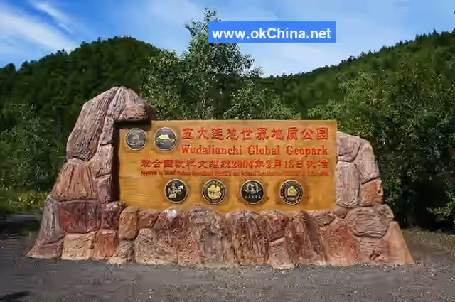
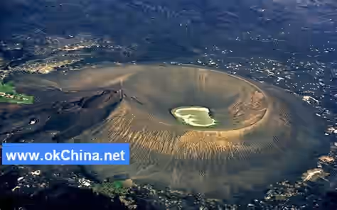
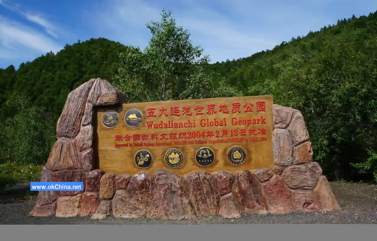
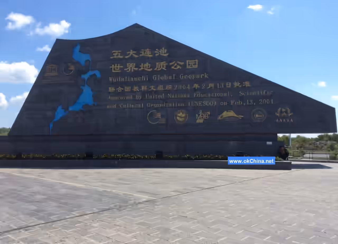
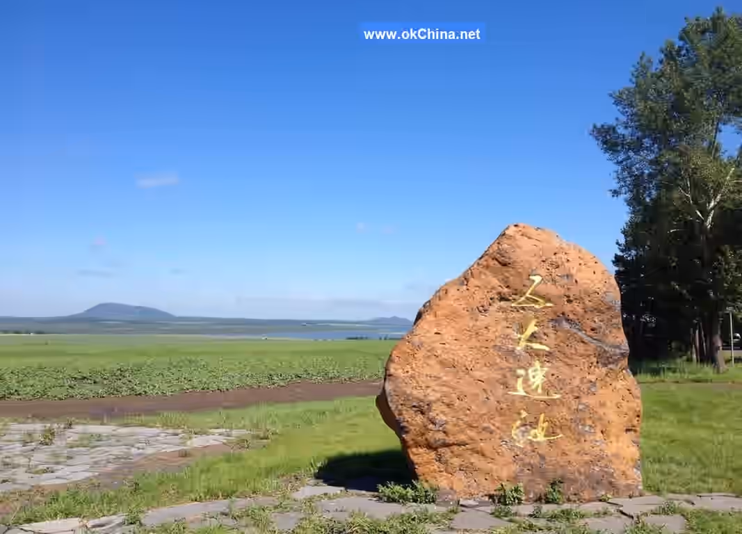
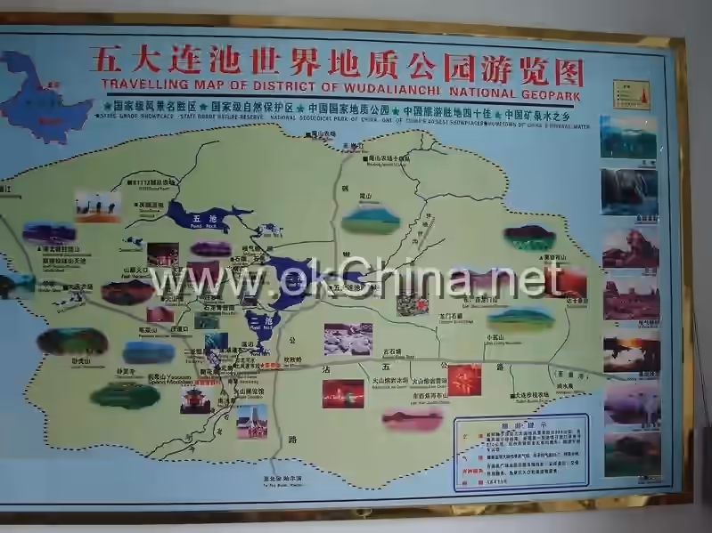
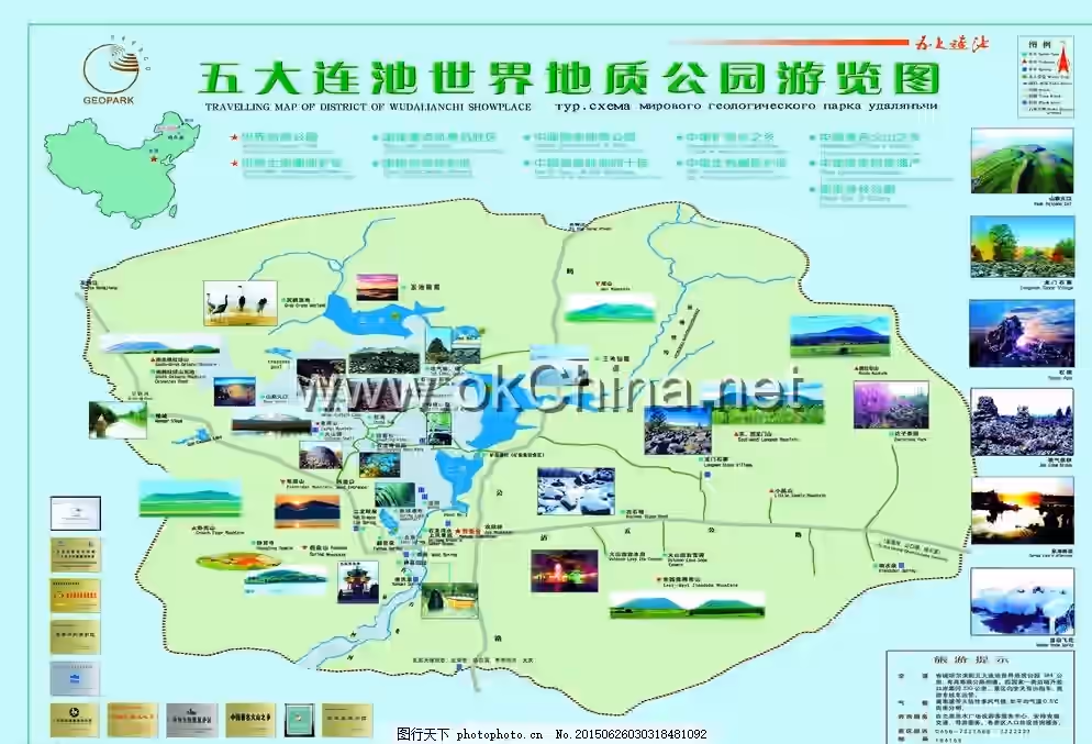
The Wudalianchi Scenic Area, located in Wudalianchi Town, Wudalianchi City, Heihe City, Heilongjiang Province, covers a total area of 720 square kilometers. It is situated 18 kilometers from the urban area of Wudalianchi City, in the transitional zone between the Xiaoxing'anling Mountains and the Songnen Plain. The Wudalianchi Scenic Area features 14 volcanic peaks from both new and old periods, over 800 square kilometers of lava, and hundreds of naturally exposed mineral springs. The lava from recent volcanic eruptions blocked ancient river channels, forming five beaded volcanic barrier lakes connected by streams. This has created a "world-class tourism resource," described by scientists as a "natural volcano museum" and an "open volcano textbook." Major tourist attractions include Longmen Stone Fortress, Laohei Mountain, and the North and South Medicinal Springs. The main scenic spots of Wudalianchi include the Yaoquan Mountain Scenic Area, the Wudalianchi World Geopark Museum, Heilong Mountain, and Wenbo. It is currently a National AAAAA Tourist Attraction, a UNESCO Global Geopark, a UNESCO Man and Biosphere Reserve, part of the IUCN Green List, a National Key Scenic Area, a National Nature Reserve, a National Forest Park, a National Natural Heritage Site, the "Hometown of Mineral Water in China," the "Famous Volcanic Hometown of China," and the "Shengshui Festival (Yaoquan Fair)," a National Intangible Cultural Heritage.
2. Geographical Environment
2.1 Location and Territory
The Wudalianchi Scenic Area is located in Dedu County, Wudalianchi City, Heilongjiang Province, in the transitional zone between the Xiaoxing'anling Mountains and the Songnen Plain. It borders the plain to the south and is backed by mountains to the north, covering a total area of 720 square kilometers. Its geographical coordinates are 125°57'00"E to 126°31'00"E and 48°33'00"N to 48°52'20"N. It extends east to the Guxi River, west to the Tuanjie Reservoir, south to the Fourth Brigade of Yongfeng Farm, and north to the Tenth Team of Gelaqiu Mountain Farm. It is 380 kilometers south of Harbin and 230 kilometers north of Heihe City, a national Class I port.
2.2 Geology
The rock composition of Heilong Mountain and Huoshao Mountain in Wudalianchi is very unique. It is a potassium-rich alkaline basic-intermediate volcanic lava. Due to its color index (40-55%) being higher than that of trachyte and phonolite (35-20%) and its lack of basic plagioclase typical of basalt, it does not belong to trachyte, phonolite, or alkaline basalt. Therefore, Japanese geologist Ogura Tsutomu named it "Shilongyan" (Stone Dragon Rock) based on the morphological features of the lava from Heilong Mountain and Huoshao Mountain, which resemble a "dragon shape." Additionally, the magma forming potassic volcanic rocks generally originates from the mantle. The upwelling and eruption of this magma are associated with specific geological tectonic environments. The Wudalianchi volcanic area is located at the axis of the East Asian continental rift system, and its formation is likely due to mantle plume uplift under rift action. The 14 volcanoes in the Wudalianchi area are all distributed at the intersections of northeast and northwest trending lines, forming a checkerboard-like layout. Geological studies have shown that the regular arrangement of the 14 volcanic cones is controlled by deep crustal fractures. The northeast and northwest trending fractures are highly developed in the Wudalianchi area, with the northeast direction being dominant. Magma from the Earth's interior erupted at the intersections of these two sets of fracture zones, forming neatly arranged volcanic cones.
2.3 Climate Characteristics
The Wudalianchi area has a mid-temperate continental monsoon climate, characterized by long, severe winters and short, cool summers. Based on meteorological data from 1980 to 2014, the multi-year average temperature is 0.88°C, with the highest recorded temperature being 38.3°C (June 24, 2010) and the lowest being -45°C (January 13, 2011). The multi-year average precipitation is 530 mm, with the maximum daily precipitation reaching 118.4 mm (July 8, 2012) and the maximum daily snowfall being 31 cm (February 18, 1992). The rainy season generally occurs from June to August. The average evaporation is 1217 mm, and the average relative humidity is 69%. Northwest winds prevail throughout the year. The freezing period lasts from October to April of the following year, with a frost-free period of about 120 days. The maximum frozen thickness is 2.47 meters, with an average thickness of about 2.15 meters.
2.4 Hydrological Characteristics
The mineral water in the Wudalianchi Scenic Area is low-temperature and naturally carbonated. Drinking spring temperatures remain around 3-4°C year-round, while bathing spring temperatures are around 6-10°C. The water contains a high amount of natural carbon dioxide gas (1000-2400 mg/L), making it pleasantly cool and refreshing to drink. Its carbon dioxide content is twice that of the world-famous Vichy mineral spring in France. Additionally, it contains a small amount of radon gas (16-18 Bg/L).
3. Main Attractions
3.1 Wenbo
Wenbo is located on the Shilong Platform and consists of Coral Pool, Jinsha Pool, and Cuiyu Pool, with water as clear as a mirror. Wenbo is a pearl on the volcanic stone dragon, featuring three bonsai-like volcanic wonders and 26 springs of various sizes, stretching over 1,800 meters. It has two unique features: First, "High Magnetic Water Bodies." Measurements indicate this is the core magnetic field area of Wudalianchi, with unerupted volcanic lava flows lying beneath Wenbo, making it an ideal area for environmental magnetic therapy. Second, "High-Cold Hot Springs." The water of Wenbo comes from underground self-flowing hot springs, maintaining a constant temperature of around 14°C year-round. Even when the ground temperature is -30°C, Wenbo remains steaming.
3.2 North and South Medicinal Springs
The North and South Medicinal Springs, along with France's Vichy Spring and Russia's Narzan Spring, are known as the "World's Three Major Cold Springs." Wudalianchi has three mineral water belts and five mineral water zones with abundant reserves. The North and South Medicinal Springs are one of these five zones. The main scenic spots include: South Medicinal Spring, North Medicinal Spring, South Bathing Spring, Yaoquan Lake, Yaoquan River, and Yaoquan Wetland. The South Medicinal Spring area comprises landscapes such as the South Drinking Spring, South Bathing Spring, the旧址 of Shenquan, Shilong Platform, and Yaoquan Wetland. It is one of the main areas of the world-famous spring health preservation zone. The mineral water of the South Medicinal Spring is bicarbonate mineral water, rich in various trace and macro elements required by the human body. The North Medicinal Spring area consists of landscapes such as the lava platform, Yaoquan Lake, the Basalt Archway, the Drinking Water Hall, the Resting Long Corridor, the Shilong Plank Road, Beiyuan Reed Viewing, the Spring Lake Waterfall, and wetland scenery. The architecture primarily follows the classical Chinese northern garden style. The North and South Medicinal Springs are collectively known as the "North and South Springs" and rank first among the "World's Three Major Cold Springs."
3.3 Wohu Mountain
Wohu Mountain is popularly known as "Longevity Mountain." It erupted between 1.053 and 1.416 million years ago, making it younger only than Gelaqiu Mountain. Among the fourteen stratovolcanoes, it has the largest cone base area and the most craters, belonging to the "composite volcano" type formed by multiple eruptions. It stands at an altitude of 496.11 meters, with four craters forming an armchair shape and a flat bottom. There is a lava overflow outlet on the northwest side. The crater diameters range from 300 to 350 meters, with depths of 20-30 meters, and the lava consists of 29 layers. The southeastern slope of this ancient volcano is the "Wohu Mountain Ecological Garden," covering over 20 hectares. It faces the ancient volcanic stone pond in front and connects to the secondary primeval forest belt above. This ecological garden features three ridge slopes, four stream waterways, and twelve visible landscapes, including Linden Hollow, Peach Blossom Slope, Red Leaf Valley, Dazixiang Slope, Mountain Flower Secluded Valley, Ancient Volcanic Fault, Wohu Pond Fishing Area for Visitors, and Wild Mountain Grape Viewing Area.
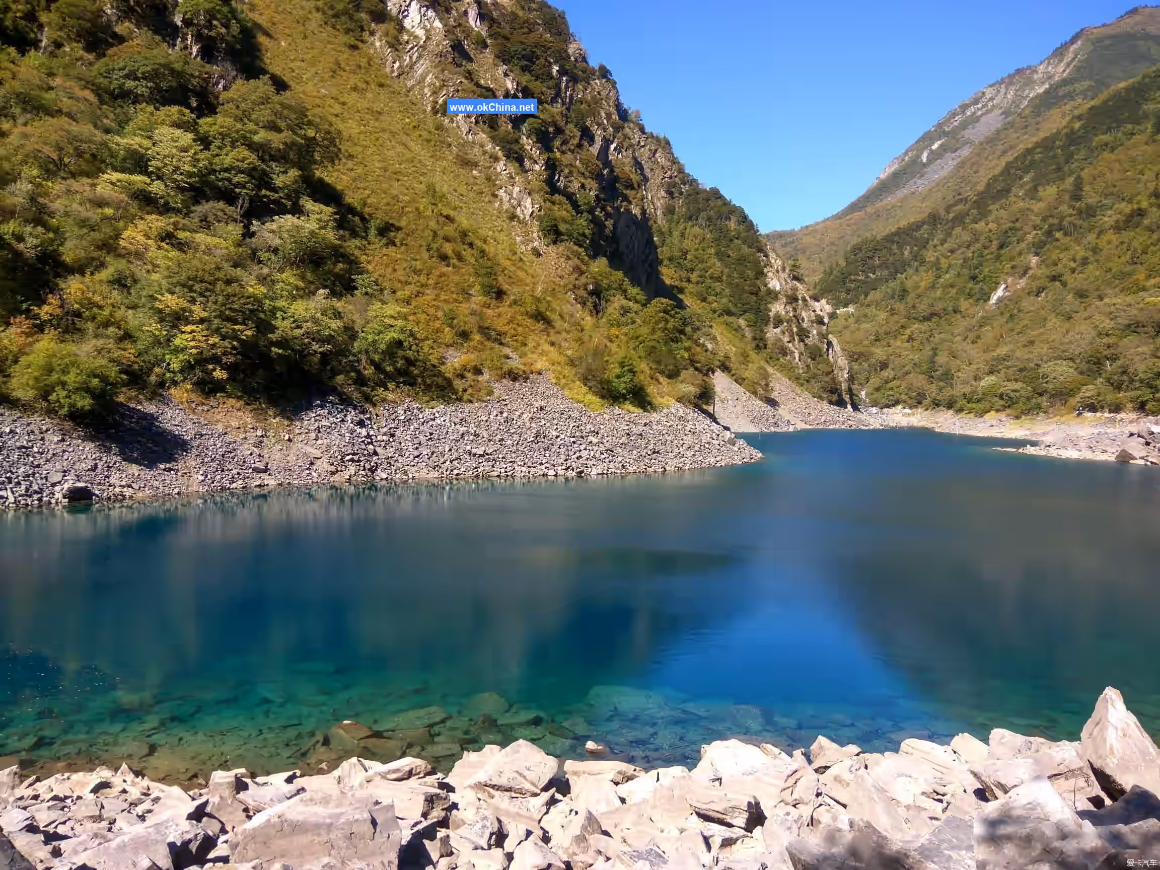
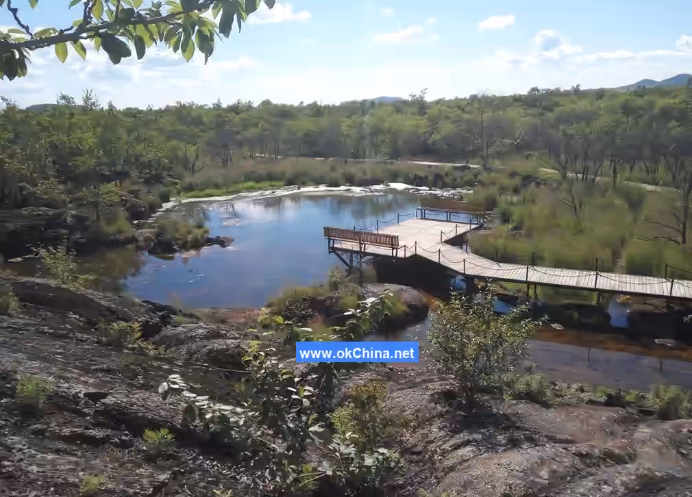
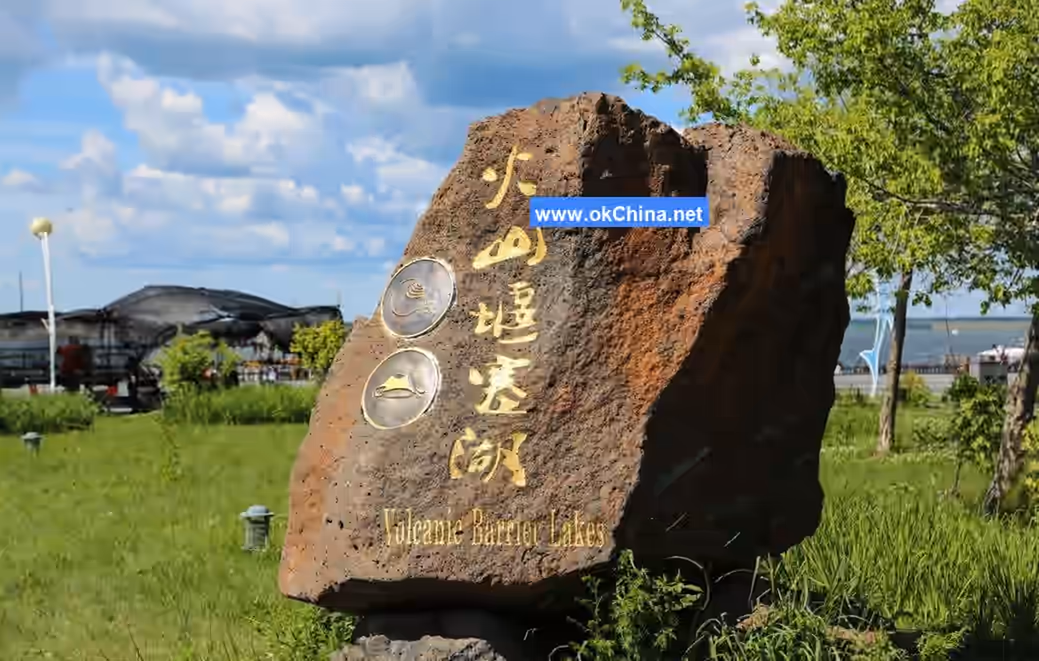
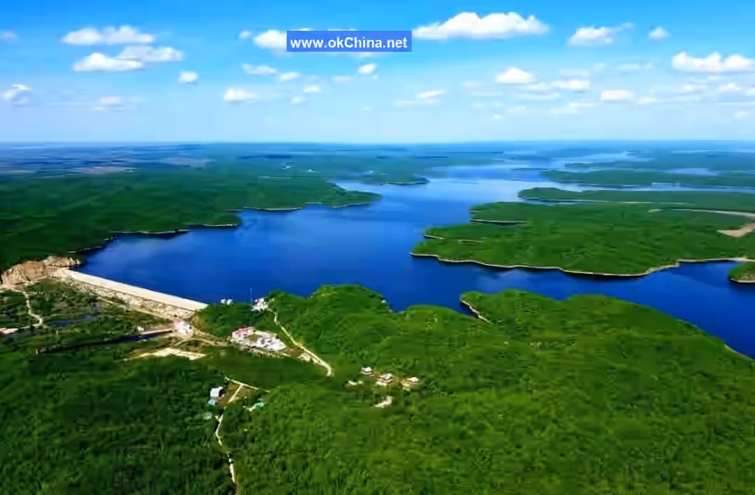
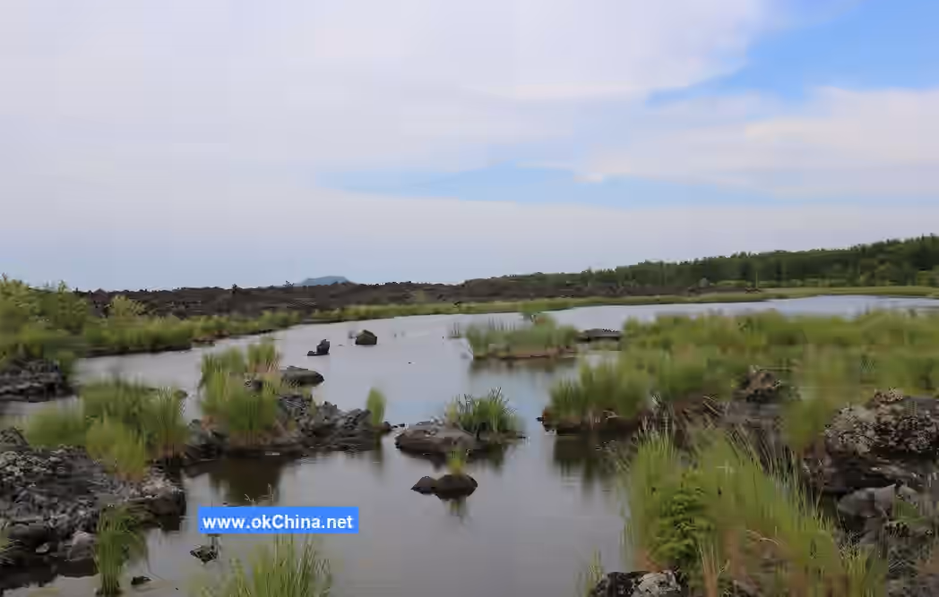
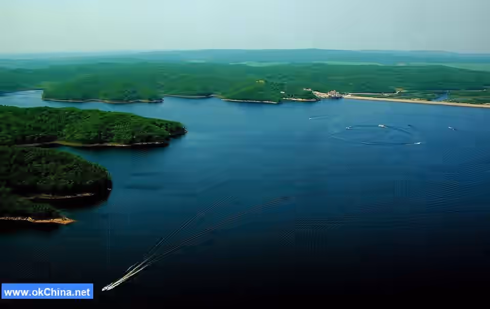
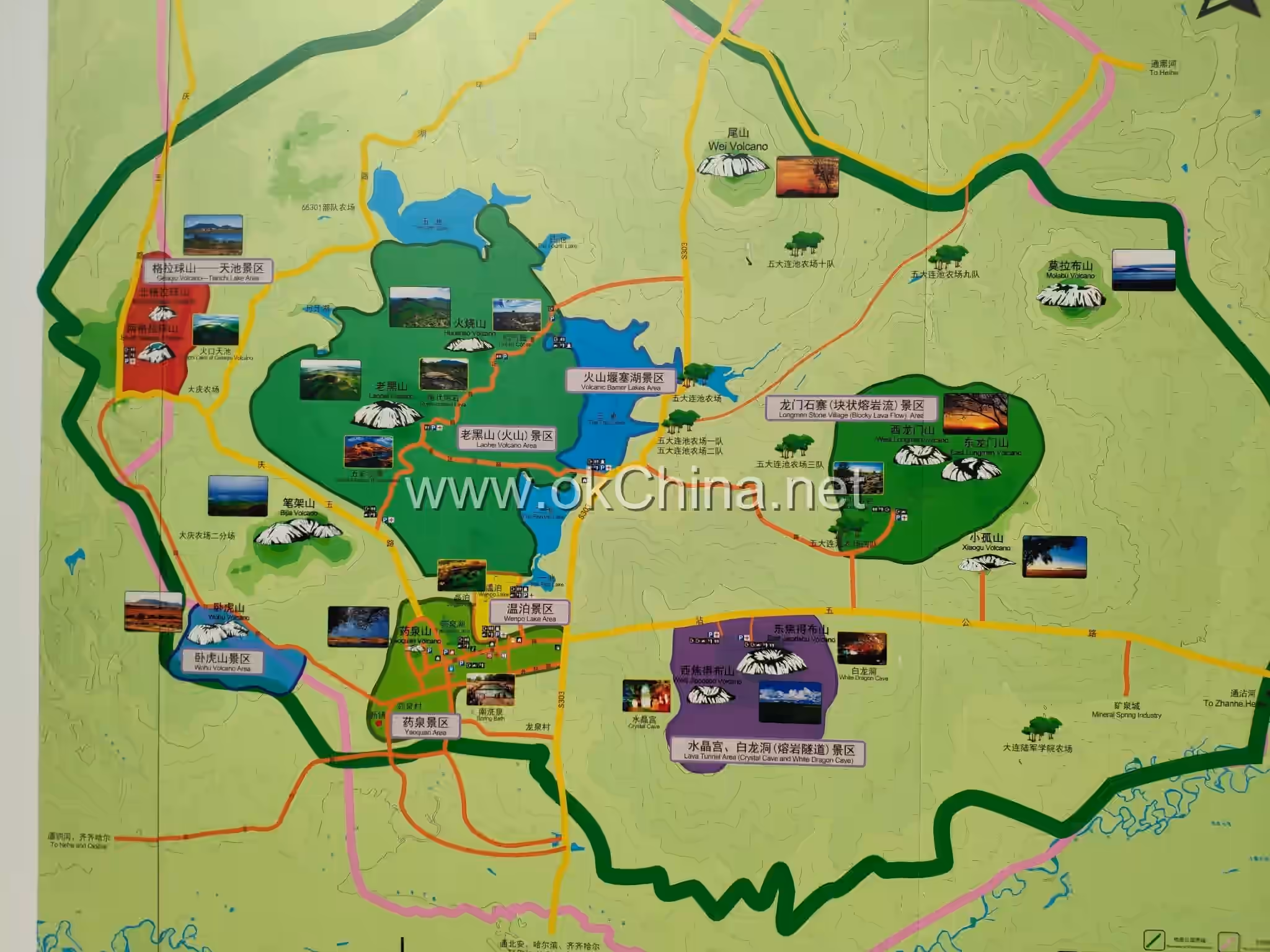
3.4 Barrier Lakes - Five Lakes Water Tour Area
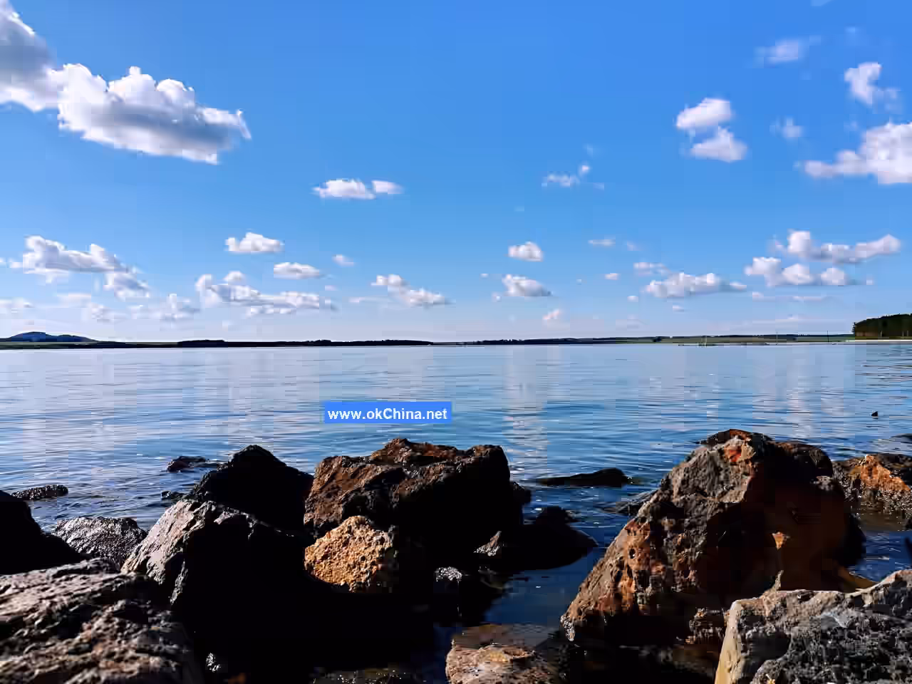
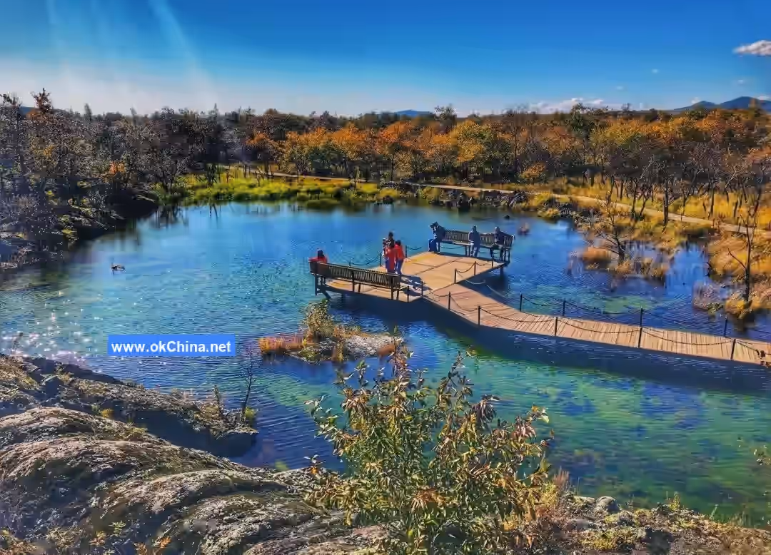
Overview The Five Connected Lakes are the core attraction of the scenic area. They form a beaded lake group consisting of Lotus Lake (First Lake), Yanshan Lake (Second Lake), Bailong Lake (Third Lake), Heming Lake (Fourth Lake), and Ruyi Lake (Fifth Lake).
3.4.1 Lotus Lake (First Lake)
Lotus Lake is the first of the Five Connected Lakes, also called Touchi (Head Lake). It is the only natural lake among the five with water lilies and has the smallest surface area, with an average depth of 2 to 4 meters. Its scenery is distinctive: first, the water lilies in the lake during summer; second, the turbulent overflow outlet during winter.
3.4.2 Yanshan Lake (Second Lake)
Yanshan Lake is a well-known natural breeding ground. Because it closely embraces the ancient island from the Yanshanian period, it is called "Yanshan Lake." It is the most ideal water surface among the five lakes for viewing the morning glow. During summer and autumn, the morning water temperature can average 30°C, and it is the area most concentrated with bighead carp.
3.4.3 Bailong Lake (Third Lake)
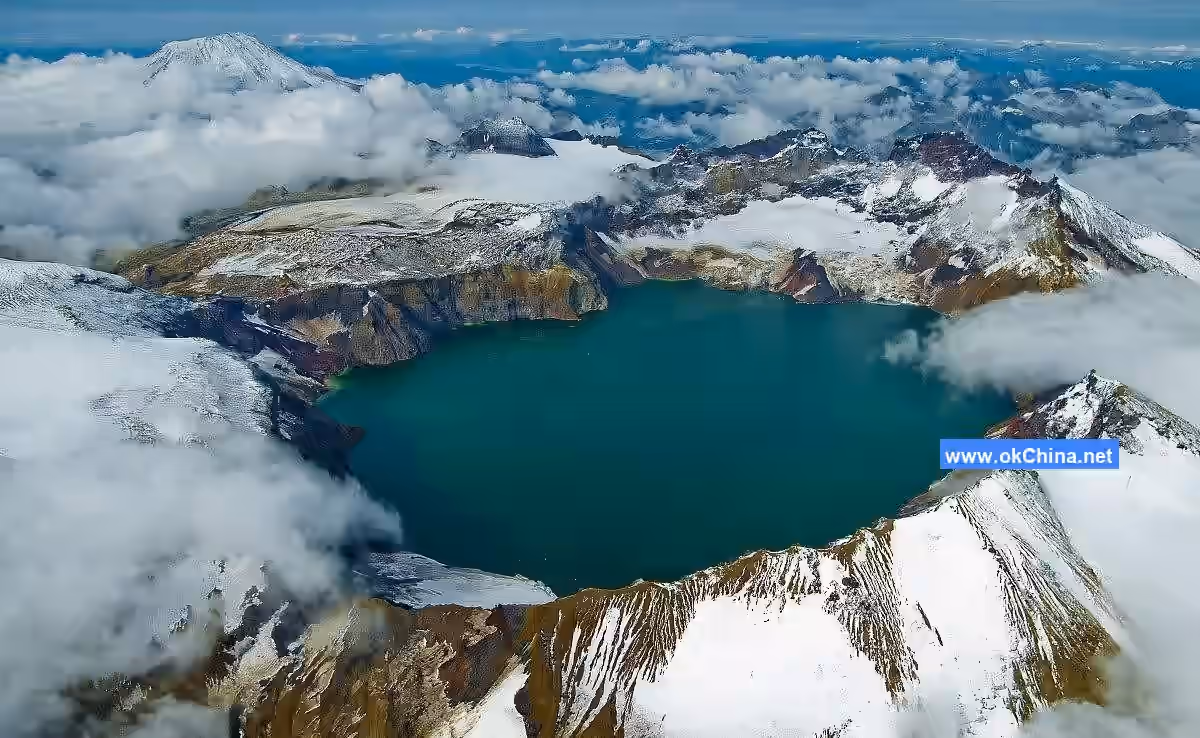
During the high-water season, Bailong Lake covers an area of 21.5 square kilometers, with the deepest point exceeding 36 meters. The lakebed is half lava and half sand. The open water surface reflects the 14 volcanoes. Bailong Lake has many legends and the most landscapes, featuring "mountain reflections" in summer and "ice breaks on the third lake" in winter. The lakeshores are flanked by new-period volcanic lava platforms and the green pastoral scenery of ancient volcanoes. Bailong Lake is an important "geological boundary lake." The western shore features new-period volcanic lava landforms, while the eastern shore consists of ancient sandstone and mudstone landforms.
3.4.4 Heming Lake (Fourth Lake)
Heming Lake is situated among reed marshes, backed by the world wonder of fumarolic cones and facing the ancient stone pond. It has a water depth of 3-5 meters. The lake is famous for crane watching in the reed marshes and its tranquil environment. It has two 50-meter-wide aquatic plant belts where emergent plants like cattails, reeds, and water caltrops are very dense. The lakebed is volcanic sand, and the lake is rich in fish, especially crucian carp. The shores of the Fourth Lake are overgrown with aquatic plants, and wild waterbirds like white cranes and red-crowned cranes often nest and fly in pairs.#### 3.4.5 Ruyi Lake (The Fifth Lake) Ruyi Lake covers a water area of 15 square kilometers with a depth of 4-6 meters, ranking as the second largest among the five lakes. From a distance, it resembles a "jade Ruyi scepter." It serves as the convergence point for the entire water system of the Wudalianchi, yet it has no rivers flowing into it nor visible streams or large springs, which is one of its marvels. Another peculiar phenomenon is the sudden appearance of waves without wind, crashing loudly against the shore. The lake is rich in "Sanhua Wuluo" fish, and its shores and bottom are composed of volcanic sand.
3.5 Lava Ice Cave Exploration Zone
3.5.1 Crystal Palace
The Crystal Palace stretches 150 meters in length and reaches a depth of 23 meters. The main hall inside the cave covers an area of 400 square meters, with two additional branching side caves. The highest point inside the cave is 6 meters, and the ceiling is dome-shaped. The average temperature throughout the year is -5°C. The cave walls are adorned with various bizarre lava flow patterns, and the ceiling features low-hanging, dripping lava stalactites. This is the site referred to in the local saying "enjoying ice and snow during the dog days of summer," one of the "Four Wonders and Four Oddities" of Wudalianchi.
3.5.2 Underground Ice River
The Underground Ice River is another lava ice cave, with a total length of 515 meters. The cave floor is covered in a smooth, mirror-like ice sheet in a stepped slope formation. At the end of the cave, two massive lava stone pillars are said to have once imprisoned a white dragon, hence the folk name "White Dragon Cave." It is currently the longest discovered volcanic underground lava tunnel in China, formed through the same process as the Crystal Palace. The scaly cave walls are covered with various thorn-like lava stalactites, all adorned with frost and ice crystals. The cave floor is frozen with ancient ice rivers, maintaining a year-round temperature of around -5°C.
3.5.3 Ancient Volcanic Botanical Garden
The Ancient Volcanic Botanical Garden is a viewing belt for secondary forest plant communities, covering approximately 200 hectares. It is divided into wildflower and arbor-shrub viewing areas. The volcanic vegetation here lies at the convergence zone of the flora from the Greater and Lesser Khingan Mountains, serving as a transition belt between cold-temperate and temperate coniferous-broadleaf mixed forests. Due to the unique effects of multiple volcanic eruptions, the area boasts a rich variety of plant species. These include over 300 species of wildflowers such as lilies, primroses, speedwell, campion, and fireweed; over a hundred species of trees and shrubs like larch, white birch, spruce, Manchurian ash, cork tree, and viburnum; and over 400 species of medicinal herbs such as barberry, balloon flower, gentian, and milkvetch.
3.5.4 Qianwolong Spring
Hidden along an ancient path within dense woods lies a vast reserve of self-gushing mineral springs. Water emerges from beneath numerous large rocks, embodying the verse: "Seeking a kindred spirit at the mineral water's source, an ancient lute plays deep within the birch forest." The spring's name originates from a folk legend: when the little black dragon was searching for the "North Sea Eye," it saw this clear spring at the confluence of three rivers in front of the Jiaodebu Mountain. It then lay down its dragon body to drink and rest, hence the name "Qianwolong Spring" (Front Lying Dragon Spring).
3.6 Yaoquan Mountain—Religious Pilgrimage Area
Overview
The Yaoquan Mountain Religious Pilgrimage Area is located in the western part of the ancient Yaoquan Town, primarily comprising Yaoquan Mountain, Zhongling Temple, Erlongyan Spring, and the Volcanic Culture Square. Yaoquan Mountain erupted between 1.05 and 1.42 million years ago. It stands at an elevation of 355.8 meters with a relative height of 65.8 meters, and its crater has a diameter of 320 meters. Due to its great age, the crater is shallow and flat. In the early 20th century, a highly revered monk traveling the world arrived here. Seeing the ancient charm of the mountain, the murmuring streams below, and the Erlongyan Spring known for curing eye ailments—said to brighten vision and bestow wisdom—he marveled at it as a sacred mountain and holy water. He made a great vow to build Zhongling Chan Temple atop the mountain. After the temple's completion, for over a hundred years, the sound of evening drums and morning bells has continued incessantly, with incense offerings never ceasing. Major Buddhist events attract devotees from all directions, making it one of the Buddhist activity centers in the northern frontier region.
3.6.1 Erlongyan Spring
Erlongyan Spring, also known as the Eye-Washing Spring, is a weakly alkaline mineral water (soda water). Besides being effective for eye diseases, it is particularly known for balancing the body's internal environment, which tends to be weakly acidic. The spring's flow rate reaches 3,000 cubic meters per day. Its rare value is comparable to the famous Nanbei Yaoquan springs. It contains strontium, has a slightly sweet taste, and a temperature below 5°C. Its composition also includes sodium, radon, bicarbonate, and others, making it an excellent base water for food, liquor, beer, and beverages. The famous mineral water tofu is processed using this water. Erlongyan Spring is one of the legendary holy springs of Yaoquan and also a primary water source for the scenic area.
3.6.2 Zhongling Chan Temple
Zhongling Chan Temple was first built in the seventh year of the Republic of China (1918). At that time, Master Jingyi, a famous traveling monk from Putuo Mountain, came to Wudalianchi in search of the "North Sea Eye" mentioned in Buddhist scriptures (as Buddhism had legends of the "Three Dragon Flower Assemblies over 560,000 years at the North Sea Eye"). He found the landscape divine, the ancient trees towering, and the local customs simple and pure—a paradise he had dreamed of, perfectly matching the classics: "Fourteen mountains in the northern frontier, five interconnected lakes; where water meets, springs gush; where caves exist, immortals dwell; the North Sea's spirit resonates, paradise is seen early." He subsequently named Yaoquan Mountain "Paradise Mountain" and proposed the temple name "Zhongling Chan Temple" (Zhong: the bell's toll connects heaven and earth, resonating with all deities; Ling: the Dharma nature is supremely wondrous, ordering all phenomena in the world). He then led monks to collect alms and build the temple. After 11 years, Zhongling Chan Temple was finally completed, covering a construction area of over 10,000 square meters with five main halls and over 200 Buddha statues, becoming a Buddhist holy land for hundreds of miles around. Later, through the devastation of war and the Cultural Revolution, this Buddhist sanctuary declined. "When flowers fall, there will be a time for them to bloom again." In the early 1990s, Master Juewu, practicing at Wutai Mountain, inherited Master Jingyi's wish. Over three years, he raised over 20 million funds to rebuild Zhongling. Zhao Puchu, then Chairman of the Chinese Buddhist Association, personally inscribed the plaque for the temple's Mahavira Hall.
3.6.3 Dragon King Temple
The Dragon King Temple is situated at the ancient volcanic lava outflow vent. The temple facing the southwestern plains is the "Dragon King Temple," where the little black dragon is the Dragon King passed down through generations by locals. After paying respects to the Dragon King, one descends via the circular staircase on the left. This path to the temple consists of 108 steps, hence also called the "Stairway to Heaven" or "Immortal's Trace." It passes by the "Mituo Courtyard," a place for lay disciples to practice and study the Dharma.
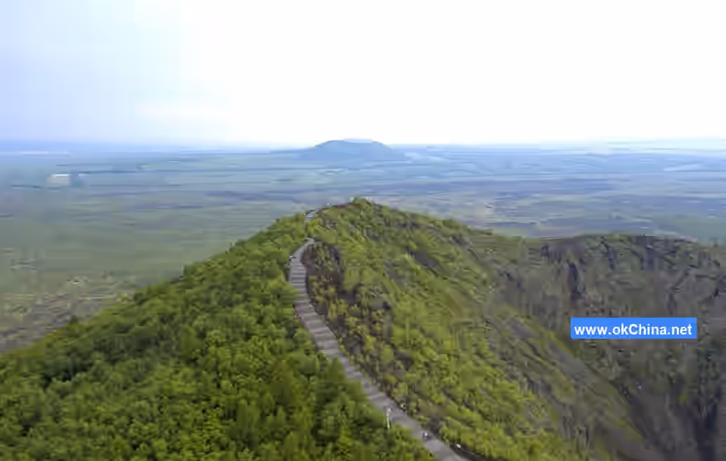
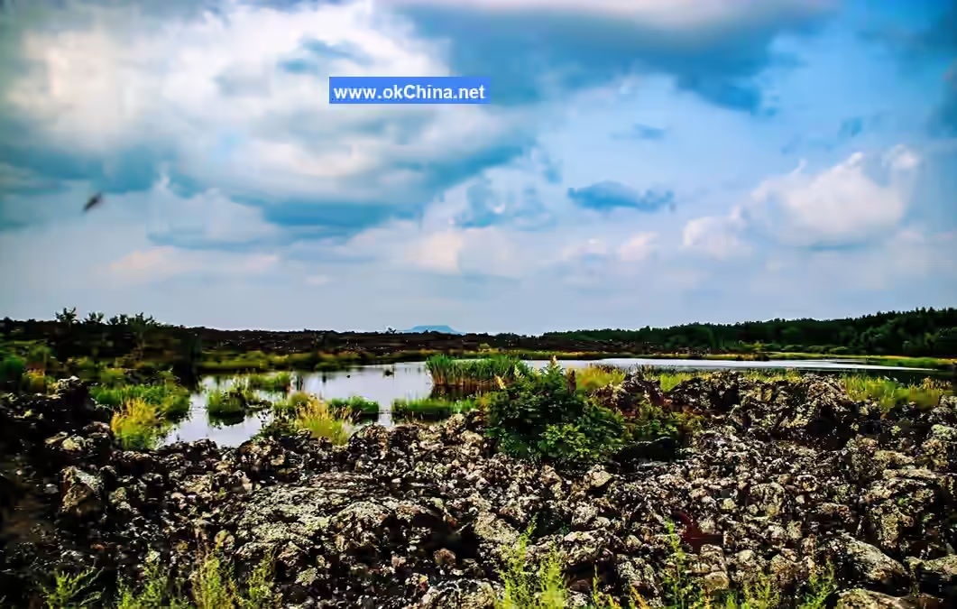
3.7 Volcanic Landform Landscapes
3.7.1 Longmen Stone Fortress
The Longmen Stone Fortress is located within the Wudalianchi Scenic Area. During the first eruption of Longmen Mountain 280,000 to 340,000 years ago, massive lava flows from the shield volcano poured down the slopes. After the upper layer solidified, the lower lava flows broke into blocks. Subsequent eruptions of Longmen Mountain and major earthquakes sifted and pushed these blocks, heaving up numerous stone blocks and pillars. The large and small stone fortresses are about a kilometer apart, with a total area of nearly 50 square kilometers.
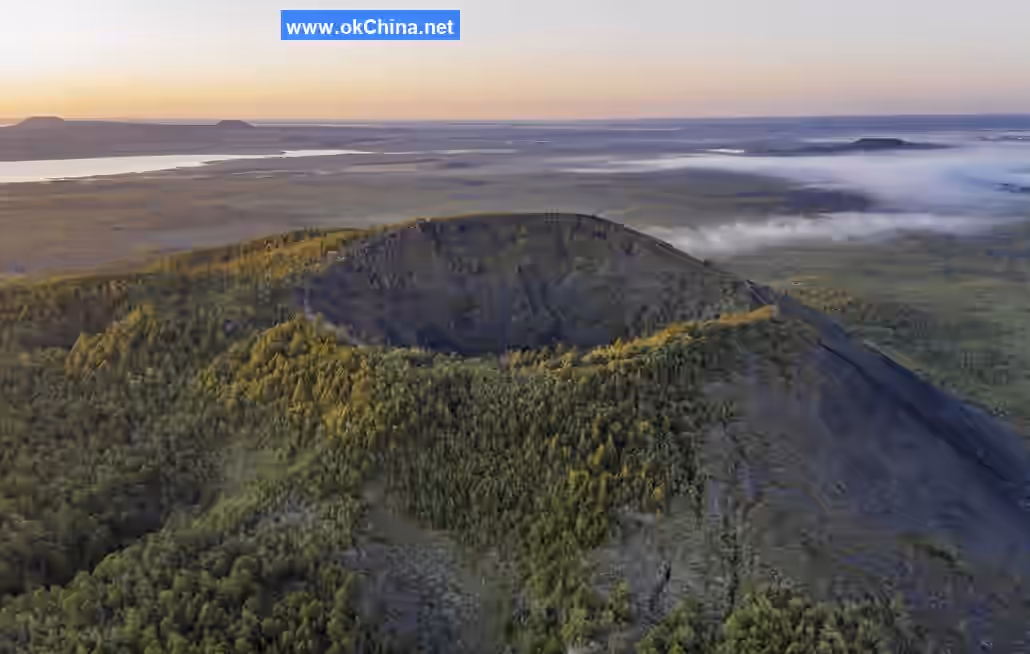
3.7.2 Gelagiu Mountain Tianchi (Heavenly Lake)
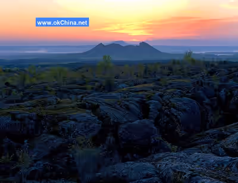
Gelagiu Mountain Tianchi is located within the crater of the South Gelagiu Volcano in the western volcanic chain. Gelagiu Mountain erupted 2.03 million years ago, with its north and south peaks only 150 meters apart. The South Gelagiu Mountain has an elevation of 596.9 meters and is a truncated cone shield volcano among the fourteen volcanoes. The volcanic body here is intact, without gaps. The summit crater is basin-shaped and once held a lake accumulated over more than 2 million years.
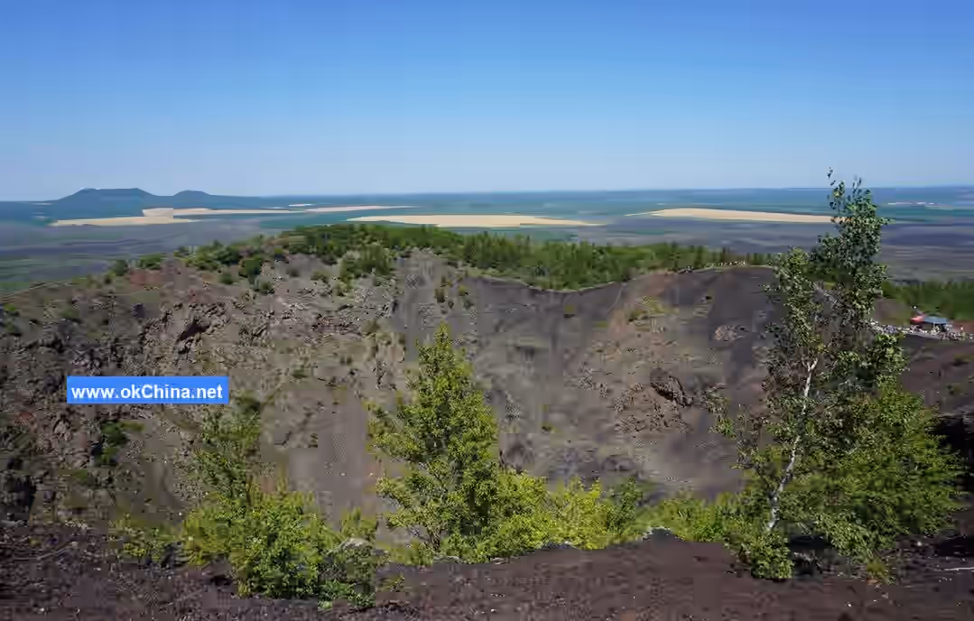
3.7.3 Huoshao Mountain (Burning Mountain)
Huoshao Mountain erupted during the same period as Heilong Mountain. The entire volcanic cone is composed of accumulated black, brown, and purple pumice and basalt. It has an elevation of 392.6 meters and a relative height of 73 meters. Its base diameter is 800 meters, with an inner crater diameter of 450 meters and a depth of 63 meters. The southern slope of the volcanic cone is relatively steep, while the northern slope is gentle. The crater rim is uneven, with a gap in the northwest that served as the channel for lava outflow. The area around the volcanic cone is relatively flat, with large expanses of volcanic lava exposed on the surface.
3.7.4 Heilong Mountain (Black Dragon Mountain)
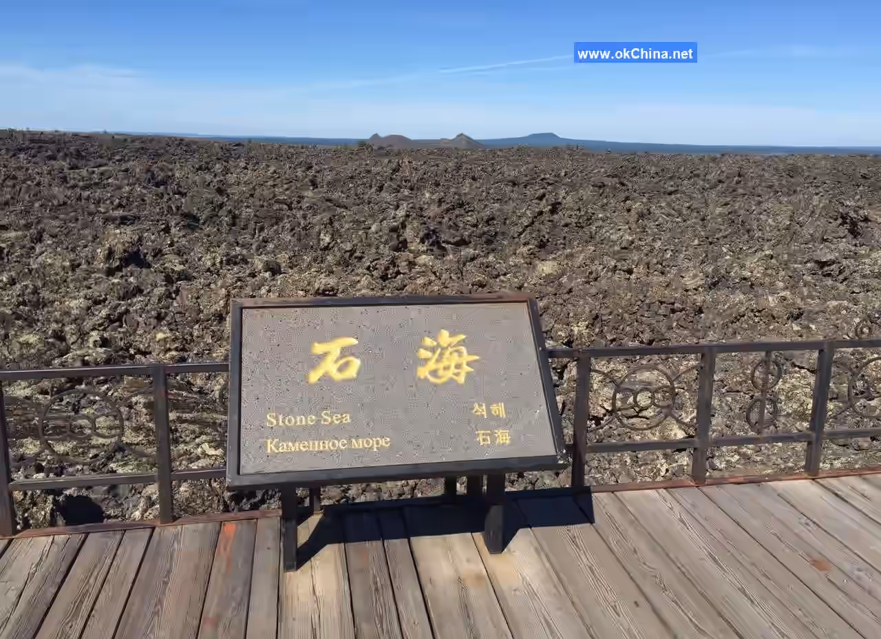
Heilong Mountain is a young volcano, formed after two eruptions in the 58th year (1719) and the 60th year (1720) of the Qing Dynasty's Kangxi era. The landscape belt covers a total area of 50 square kilometers. The geological formation of Laohei Mountain and Huoshao Mountain dates back over 280 years. Main attractions include Heilong Mountain (Laohei Mountain), the summit crater, Stone Sea, Fairy Palace, Huoshao Mountain, and fumarolic cones and discs. There are also 59 other sites such as Bonsai Garden, Stone Dragon Moss Garden, Colorful Sand Beach, Sea of Fire Remnants, Unique Pine Garden, Volcanic Bombs, Crater Forest, Lansheng Peak, Tenglong Valley, Volcanic Chasm, Lava Outflow Vent, Water Curtain Cave, Parasitic Volcano, Holly Garden, Tranquil Birch Forest, Lava Stone Dragon, Stone Sea Creatures, Stone Flower Garden, Bagua Lake, Huoshao Mountain Grand Canyon, Mysterious Pool, Knife-Cleaved Gorge, Burning Castle, Stone Ape, Stone Bear, and Birch Forest Boiling Spring.
3.8 Volcanic Geology Museum
The Wudalianchi Volcanic Geology Museum is situated in the central area of the new town within the Wudalianchi UNESCO Global Geopark. It occupies a total land area of 26,000 square meters, with a total floor area of 15,000 square meters and an exhibition area of 8,500 square meters. The internal exhibition space is primarily divided into five main halls: World Volcanoes and Global Geoparks, Wudalianchi Volcanoes, Wudalianchi Mineral Springs, Wudalianchi Ecology, and Wudalianchi Culture.
4. History and Culture
4.1 Origin of the Name
Between the 58th year (1719) and the 60th year (1721) of the Qing Dynasty's Kangxi era, volcanic eruptions in Wudalianchi caused lava flows to block the Baihe River channel, forming five interconnected lakes resembling a string of beads, hence the name Wudalianchi (Five Interconnected Lakes).
4.2 Myths and Legends#### 4.21 The Legend of Huoshao Mountain
Not far from the northwest corner of the Third Pond in Wudalianchi, there stands a volcano named Huoshao Mountain (Burning Mountain). According to historical records, it erupted in the seventh month of the lunar calendar during the Kangxi reign of the Qing Dynasty (1720 AD). The scene of the eruption was quite spectacular at the time: mountains collapsed and the earth split, thunderclaps suddenly roared; raging fires and thick smoke billowed unceasingly; rocks flew across the sky like a sudden downpour; scorching heat waves drove away all birds and beasts. After this, a magical legend has been passed down. It is said that at the very moment Huoshao Mountain erupted, it was like a skyrocket shooting straight up beyond the highest clouds. From the junction between the burning sea of fire at the deepest layer and the rolling thick smoke, a fireball-like monster soared out and vanished like a flash of lightning. Many years passed, and the lava that flowed out during the eruption of Huoshao Mountain cooled and turned into vast stretches of stone dragons and stone seas. On the open ground between them, wild grass and forests grew. Many more years passed, and gradually, human settlements appeared on the land where wild grass and forests had grown.
4.22 The Legend of the Divine Deer Revealing the Water
For thousands of years, a story has been circulating in Wudalianchi: Many years ago, on the Dragon Boat Festival, a young Daur hunter went hunting at the foot of Yaoquan Mountain (Medicine Spring Mountain). He shot and wounded a sika deer with an arrow. The fawn, carrying its arrow wound, ran toward a divine spring. The hunter chased closely behind and saw it leap into the water, using the spring water to clean its wound. The bleeding soon stopped, and then it disappeared swiftly into the forest. The stunned hunter quickly scooped up some water to drink, finding it pungent and cool, instantly relieving his fatigue. The Daur hunter, who always revered spirits, immediately understood that the divine deer had guided him to discover this sacred spring water. He knelt and kowtowed in worship, then piled up stones as a marker. After returning home, he led his clanspeople to come here to drink and bathe. Those with wounds rinsed them and quickly recovered; it also showed remarkable effects in treating stomachaches, back, and leg pains. This matter gradually spread to nearby Manchu, Mongol, Ewenki, and Oroqen communities, and people all called it the "Yaoquan" (Medicine Spring). Everyone firmly believed this was the guidance of the "Goddess of Holy Water," allowing the hunter to discover this medicine spring. From then on, they established this day as a festival. Every year at this time, people gather joyously at Yaoquan to hold commemorative and celebratory activities. Han Chinese call this festival the "Yaoquan Gathering," while ethnic minority folks call it the "Holy Water Festival." During the festival, children of all ethnic groups herd, hunt, drink water, and bathe in the springs by day; by night, they revel around bonfires, singing, dancing, and drinking. Men and women, old and young, are filled with joy, gradually dispersing only after a month. When leaving, they tie red silk ribbons to tree branches, signifying the expulsion of illness and a year of peace and health—a tradition that continues to this day. The spring under the stone tablet at the old site of the divine spring is where the divine deer revealed the water that year, also called the "Old Site of the Divine Spring."
4.23 The Legend of Wudalianchi
Wudalianchi is a famous scenic spot in China. Legend has it that long ago, all sorts of spirits lived in the ponds. At that time, a pair of brothers lived by Wudalianchi. The elder brother was named Mohai, honest and steady; the younger brother was named Mojiang, enthusiastic and lively. Both brothers were excellent hunters. Mojiang also had a naturally beautiful voice and sang wonderfully. One year, on the night of the fifteenth day of the seventh lunar month, the moonlight was exceptionally bright. Mojiang, returning from hunting, passed by Wudalianchi and suddenly heard a splashing sound from the water. He quickly hid in the grass by the shore, wanting to see what was happening. After a short while, three maidens suddenly emerged from the water. They all had sparkling large eyes and rosy cheeks, extremely beautiful. Mojiang couldn't help but stare, mesmerized. The three maidens stood on the lake surface, waved their hands, and instantly many spirits holding various musical instruments emerged from the water. They waved their hands again, and immediately enchanting, beautiful music sounded over the ponds. The three maidens sang and danced along with the music. Mojiang watched, entranced, and unconsciously stood up with the song, rustling the grass leaves beside him and making a noise. At that moment, a wave surged on the pond surface. After the wave disappeared, the pond surface became smooth as a mirror, and the three maidens had vanished. After returning, Mojiang kept thinking about those three maidens. So, every night he went to the pondside to sing, hoping his beautiful songs would lure the three maidens out. On another clear, moonlit night with a gentle breeze, Mojiang came to the stone ledge by the pond, opened his voice, and began to sing. Suddenly, he heard in the distance what seemed like someone harmonizing with his voice, also singing. Listening carefully, it was precisely the voices of those three maidens. Mojiang was overjoyed and sang even more loudly: "Singing on high mountains echoes far and wide, singing on water sounds clear and bright. Singing together on mountains and water, oh, why do you hide away in the water?" The three maidens sang: "Hearts in the world are not the same, good and bad are hard to guess. Kind songs warm people's hearts, oh, evil-hearted villains lose all conscience!" Mojiang sang again: "I am a hunter named Mojiang, specializing in killing tigers, leopards, and wolves. Kind-hearted and a good man, oh, I love hard-working good maidens most." The three maidens sang again: "We are fish maidens in the water, loving kind-hearted men in the mortal world most. Hearing your song, we know your heart, oh, please come over and let's talk!" One maiden beckoned to Mojiang, and he immediately felt his body become light and float over to the three maidens. They sang and chatted until daybreak before parting. From then on, Mojiang and the three fish maidens became good friends. They agreed to meet and sing by the pond every fifteenth of the month. Mojiang was always very punctual. But one day, the three fish maidens waited for a long time without seeing Mojiang arrive. Upon inquiry, they later learned that Mojiang had accidentally shot the county magistrate's carrier pigeon and had been captured and thrown into jail. The three fish maidens were very worried and immediately went to reason with the county magistrate. The magistrate said he would only release Mojiang if compensated with one thousand taels of silver. Hearing this, the fish maidens said, "We have no silver, but how about giving you one thousand pearls instead?" The magistrate was very pleased and quickly agreed. The next day, the fish maidens indeed brought one thousand pearls. The magistrate accepted the pearls and released Mojiang. Mojiang was extremely grateful to the fish maidens. The fish maidens pursed their lips, held back laughter, shook their heads, and said nothing. The magistrate, holding the perfectly round, beautiful pearls, was overjoyed. Suddenly, the pearls emitted faint cracking sounds, and gradually, all one thousand pearls burst open, turning into one thousand tiny streams of water. It turned out these pearls were water droplets transformed by the three fish maidens. The magistrate was half-drowned. Knowing he had encountered spirits, he could only admit his misfortune.
4.24 Folk Legend
Over two million years ago, the area of Wudalianchi was a vast ocean called the North Sea. The sea teemed with a great variety of thriving plants and animals; ruling the underwater world of fish, the carp reigned as king. The leader was a carp spirit with considerable magical powers, named Liang. To consolidate its ruling position, it was adept at uniting all kinds of plants and animals. It sent a trusted aide, a silver carp, specifically to handle this work. Following the example of Confucius from the Spring and Autumn and Warring States period, it embarked on a journey throughout the entire North Sea, preaching the benefits (principles) of forming alliances to build a shared homeland. However, the silver carp met with ruthless opposition and nearly lost its life.
Comments
Post a Comment