

Volcanic Hot Sea
1. Introduction
The Baoshan Volcanic Hot Sea Tourist Area, abbreviated as the Volcanic Hot Sea Tourist Area, is located within Tengchong County, Baoshan City, Yunnan Province, and Lianghe County, Dehong Dai and Jingpo Autonomous Prefecture. It comprises the Volcanic Scenic Area and the Hot Sea Scenic Area. The Hot Sea Scenic Area is situated at an altitude of approximately 1520 meters and covers an area of about 9 square kilometers. The Volcanic Scenic Area is one of the four major volcanic groups in mainland China, consisting of Cenozoic dormant volcanoes, with an area of 221.36 square kilometers.
Tengchong lies near the collision zone of the Eurasian Plate and the Indochina Plate, resulting in intense underground magmatic activity. At depths of 7 to 25 kilometers underground, there are still two magma chambers with diameters of 10 to 30 kilometers. Due to the well-developed near-north-south fault system, the thermal energy from these magma chambers is continuously released here, forming the Tengchong geothermal field. The Hot Sea Scenic Area is the region with the most concentrated geothermal manifestations in Tengchong, gathering numerous high-temperature hot springs and gas springs. Due to the youthfulness, multi-phase nature, diversity of eruption activities and types, variety and completeness of volcanic rock series, and the excellent preservation state of volcanic geological relics (including various volcanic structures, landforms, rocks, etc.) in Tengchong, combined with the rich and intense geothermal activity landscapes and relics, it constitutes the only region in the People's Republic of China featuring a complete combination of volcanic and geothermal landscapes.
In 2016, the Baoshan Volcanic Hot Sea Tourist Area successfully passed the national 5A-level tourist attraction assessment, becoming China's only national AAAAA-level tourist attraction characterized by unique volcanic hot spring resources.
2. Geographical Environment
2.1 Location and Territory
The Baoshan Volcanic Hot Sea Tourist Area is located within Tengchong County, Baoshan City, Yunnan Province, and Lianghe County, Dehong Dai and Jingpo Autonomous Prefecture. Tengchong County forms the main part, spanning from 98°10′ to 99°14′ east longitude and 24°32′ to 25°39′ north latitude.
2.2 Geology
Tengchong lies near the collision zone of the Eurasian Plate and the Indochina Plate, resulting in intense underground magmatic activity. At depths of 7 to 25 kilometers underground, there are still two magma chambers with diameters of 10 to 30 kilometers. Due to the well-developed near-north-south fault system, the thermal energy from these magma chambers is continuously released here, forming the Tengchong geothermal field.
2.3 Climate
The Baoshan Volcanic Hot Sea Tourist Area has a continental subtropical climate, characterized by mild temperatures, abundant rainfall, distinct dry and wet seasons, and significant diurnal temperature variations.
3. Main Attractions
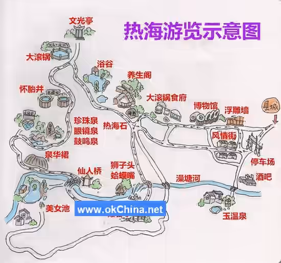
3.1 Hot Sea Scenic Area
The Hot Sea Scenic Area features a circular tour route with a total length of 5 kilometers. Natural landscapes include the Big Boiling Pot, Pregnancy Well, Drumming Spring, Eyeglass Spring, Pearl Spring, Sinter Skirt, Frog Mouth, and Lion Head. Cultural landscapes include the Hot Sea Stone inscribed by Li Genyuan and the Wenguang Pavilion.
3.1.1 Frog Mouth
Located next to the Zao Tang River Waterfall, this spring group is named for its resemblance to an "open-mouthed frog" and is China's only pulsating boiling geyser. Due to gases mixed within the high-temperature spring water, it exhibits intermittent eruptions, forming its characteristic pulsating jet. Over time, the spring mouth has accumulated white siliceous sinter deposits, while the surrounding area hosts many high-temperature algae appearing green. From a distance, it strikingly resembles a large frog. As an intermittent spring, it seems like a group of frogs spitting water rhythmically, hence also known as "Frogs Spitting Water."
3.1.2 Pearl Spring
The lines "For millennia boiling with a hundred pores of steam, a pool of spiritual springs yields ten thousand pecks of pearls" describe the Pearl Spring, which is heart-shaped. The spring water contains hundreds of gas vents from which strings of bubbles rise gracefully, crystal clear and multicolored, creating a pearl-like spectacle.
3.1.3 Drumming Spring
The Drumming Spring is a boiling spring pit and steam vent, boasting the highest water flow among the Hot Sea hot springs. As the spring water changed course multiple times, it formed many cavities. Being an intermittent spring, the periodic eruption of water causes resonance within these cavities, producing a drumming sound reminiscent of war drums from ancient battlefields, hence its name.
3.1.4 Eyeglass Spring
Also known as the Sister Spring, the Eyeglass Spring is located on the right bank of the Hot Sea Zao Tang River, downstream from the Pearl Spring. It is formed by sinter deposits and resembles a pair of eyeglasses, hence the name. It also has an alternative name, "Bottomless Pit," because its water outlet is spiral-shaped, and the water channel is inclined, sucking in sediment while discharging water.
3.1.5 Pregnancy Well
The Pregnancy Well consists of two similar wells: the Dragon Well on the left and the Phoenix Well on the right. The well curbs are composed of twelve stone balustrades carved with the twelve Chinese zodiac animal patterns. This spring is rich in trace elements and has effects such as promoting metabolism and regulating endocrine functions. It is particularly effective for women with irregular menstruation and endocrine disorders, often bringing hope to infertile women, earning it the name "Guanyin Bestowing Children" created by nature.
3.1.6 Big Boiling Pot
The "Big Boiling Pot" is so named because the boiling water churns and rolls, emitting steam and mist with grand momentum, resembling a giant pot of boiling water. Over 300 years ago, Xu Xiake visited and described it: "The pool is four to five mu in size, sunken in the middle like a cauldron, holding water only halfway, its color turbid white, boiling from below. It appears as rolling surges, with even fiercer force." Over 60 years ago, Mr. Li Genyuan, while seeking treatment and recuperation at the Hot Sea, also composed a poem: "The hot sea churns waves, stirring angry tides; Fierce flames burn fiercely beneath the earth; Yin and yang stir, all are spring's intent; Flowing to fill the river, moistening crops and seedlings."
3.1.7 Geothermal Geology Museum
Built in 1998, the Geothermal Geology Museum covers an area of 1594.3 square meters. Its exhibition, themed "Geothermal Wonders of the Remote Border Sacred Land," provides a very detailed introduction to the specific volcanic and geothermal geological conditions of the Tengchong area.
3.1.8 Hot Sea Hot Springs
The Hot Sea Hot Springs consist of two hot spring areas: Bath Valley and Beauty Pool. Representative spring qualities include the "Healing Soup" sulfur spring, the "Skin-beautifying Spring" bicarbonate spring, the "Beauty Heat Soup" chloride spring, the "Magical Heart Soup" carbonate spring, the "Gout Soup" radioactive spring, the "Joint Anemia Soup" iron spring, and the "Child-bestowing Soup" potable radon-fluoride spring. The Bath Valley hot spring area also features a unique "Gas SPA" natural geothermal steam bath.
3.1.9 Bath Valley Hot Spring
Built following the mountain terrain, Bath Valley Hot Spring features pavilions, terraces, towers, small bridges over flowing water, and vibrant flowers, plants, and trees. Hot spring pools, private bath houses, and geothermal steam areas together create a rich and wonderful picture of hot spring SPA culture and garden art, truly a world of mountain hot spring wellness.
3.1.10 Beauty Pool Hot Spring
Also known as the Immortal's Bathhouse, the Beauty Pool Hot Spring is nestled in the heart of the Hot Sea Scenic Area, surrounded by mountains. It is formed by the natural outflow of hot boiling springs from attractions like the Drumming Spring, Pearl Spring, Pregnancy Well, and Sister Spring on the hillside, which naturally cool as they flow down and converge. The spring water absorbs the essence of numerous sources, resulting in a smooth and delicate quality with unique effects for beautifying the skin, dispelling wind, and removing dampness.
3.1.11 Sinter Skirt
The Sinter Skirt is formed by the long-term downhill flow of high-temperature spring water from the Pearl Spring, Eyeglass Spring, Drumming Spring, and Pregnancy Well we are about to visit. As the temperature gradually decreases during flow, solubility also drops, causing high concentrations of silicon, sodium, calcium, magnesium, and sulfur ions in the spring water to precipitate along the way, forming colorful folded deposits resembling a gorgeous pleated skirt, hence the name "Sinter Skirt." Sinter refers to chemical deposits of mineral-laden geothermal water and steam on the surface, which can be classified by composition into siliceous sinter, calcareous sinter, sulfur sinter, nitrate sinter, etc., presenting colorful landscapes.
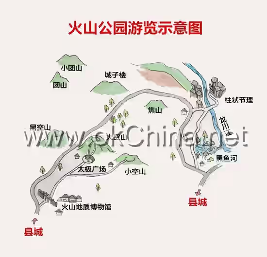
3.2 Volcanic Scenic Area
The Volcanic Scenic Area is characterized by its volcanic geology and landforms. Main attractions include Big Empty Mountain, Small Empty Mountain, Black Empty Mountain, Divine Pillar Valley (Columnar Jointing), and Black Fish River. Except for the volcanic cones, the entire scenic area is covered by volcanic lava. Multiple volcanoes are distributed adjacent to each other, with typical volcanic geology and landforms all around, showcasing large areas of lava flows and lava plateaus. The Longchuan River Gorge runs along the eastern edge of the scenic area, with gorge walls composed of basalt columnar jointing, resembling natural murals accompanying the Longchuan River waters, earning it the title "Natural Volcanic Geology Museum."
3.2.1 Small Empty Mountain
Small Empty Mountain is also a flat-topped conical volcano, with an altitude of 1957 meters, a base diameter of about 350 meters, and a crater diameter of 250 meters. The height difference is 30 meters on the north side and 60 meters on the west side, with a crater pit depth of 60 meters.
Small Empty Mountain formed around the same time as Big Empty Mountain and also experienced two eruptions. During eruptions, the volatile components of the magma were not abundant, preventing the accumulation of a taller cone. The very bottom of the volcanic crater retains the original lava lake surface. On the eastern side of the cone, a later intruded crescent-shaped lava dome, about 200 meters in diameter and 50 meters high, resulted from the slow upward intrusion of magma after the main volcanic conduit sealed, hence lacking a distinct crater.
3.2.2 Big Empty Mountain
Big Empty Mountain is a flat-topped conical volcano, with an altitude of 2080 meters, a mountain base diameter of 650-720 meters, and a crater diameter of about 200 meters. Its relative height is 100 meters, with a crater pit depth of 50 meters. The ascending stone staircase has 597 steps, while the descending one has 598 steps, symbolizing "seven up, eight down" (a Chinese idiom implying unease or fluctuation).
On the northern mountainside of the volcanic cone, there are remnants of a small eruptive vent. Near the base on the southern side of the cone, there are lava overflow outlets and lava ridges. Big Empty Mountain experienced two major eruptions: the first, about 360,000 years ago, was a quiet eruption; the second, about 250,000 years ago, was an explosive eruption, forming pyroclastic rocks manifested as rhyolite, volcanic bombs, pumice, etc. During the eruption, olivine basalt lava flowed extensively in all directions, forming a lava sheet, while the central crater area retained a hollow volcanic cone composed of basaltic scoria, volcanic bombs, and lava masses.#### 3.2.3 Divine Pillar Valley
Like a window into the Earth, it reveals traces of intense internal movements and compression. The columnar joints here are irregularly shaped into four-, five-, and six-sided forms, predominantly hexagonal, arranged in a staggered yet orderly pattern with horizontal, vertical, inclined, and curved formations—a masterpiece of nature's craftsmanship. Due to its mysterious and majestic presence, as if aided by divine power, it is acclaimed as the Divine Pillar Valley.
3.2.4 Black Fish River
Black Fish River is a surface manifestation formed by magma blocking underground water channels under the influence of lava flows. The giant spring of Black Fish River has an enormous flow rate, with its outlet splitting into two branches. It derives its name from the thousands of black fish that flow out from the outlet every summer and autumn.
3.2.5 Heikongshan (Black Empty Mountain)
Heikongshan stands at an elevation of 2,072 meters, with a lava area of approximately 27 square kilometers, making it one of the best-preserved volcanic structures in the region. The lower part of the volcanic cone consists of a lava cone, while the upper part is a scoria cone, with a relatively intact crater rim. Since the Late Pleistocene, Heikongshan has experienced multiple intermittent eruptions, with distinct lava outlets on the northern and southern sides of the cone. Large-scale lava flows extend westward, northward, and eastward from the cone. The southern lava flow overlays the lava flow of Dakongshan (Big Empty Mountain), while the northern flow overlays that of Tuanshan (Round Mountain). Lava tubes and lava collapses are relatively common.
4. Naming
In the 12th year of the Ming Chongzhen era (1639), the Ming dynasty geographer Xu Xiake visited Rehai (Hot Sea) and provided a detailed and vivid description of its geothermal landscape. During the Ming and Qing dynasties, it was referred to as "a pool of hot sea" and was one of the twelve scenic spots of ancient Tengyue. Hence, it came to be known as "Rehai" (Hot Sea).
5. Volcanic Activity
The ages of volcanic rocks in the Tengchong volcanic cluster in Yunnan range from several million to several hundred years. Based on previous data on volcanic rock ages, the volcanic eruptions in Tengchong can be divided into five phases:
- Phase I: Pliocene N2, eruption period 3.83–2.71 Ma. Due to prolonged and intense weathering, most volcanic cones have been destroyed, leaving only dome-like landforms or volcanic bodies. The volcanic rocks are effusive or eruptive mafic rocks, primarily distributed in the southern part of the volcanic area, with a small amount in the northern part.
- Phase II: Early Pleistocene Q1P, eruption period 1.99–0.84 Ma. Most volcanic structures have been damaged, and craters are no longer distinct, though conical mountain bodies remain visible.
- Phase III: Middle Pleistocene Q2P, eruption period 0.72–0.131 Ma. The volcanic rocks are explosive or eruptive phases, with volcanic activity developing from the ends of the basin toward the center. Most volcanic rocks are acidic dacite, with the Daliuchong area being the most typical. Volcanic structures from the Middle Pleistocene are relatively well-preserved, with most craters still visible.
- Phase IV: Late Pleistocene, eruption period 0.078–0.013 Ma. The eruption range narrowed, mainly concentrated in the center of the basin, with eruptions occurring in areas such as Dayingshan (Eagle Mountain), Ma'anshan (Saddle Mountain), Heikongshan, and nearby Dakongshan and Xiaokongshan (Small Empty Mountain).
- Phase V: Holocene volcanoes. Heikongshan, Dayingshan, and Ma'anshan continued to erupt during the Holocene. Their volcanic structures are well-preserved, featuring truncated conical volcanic cones, elliptical craters, and explosive-eruptive phases dominated by intermediate rocks.
Comments
Post a Comment