

Alxa Populus Euphratica Forest Tourist Area
1. Introduction
The Alxa Populus Euphratica Forest Tourist Area, also known as the Ejin Populus Euphratica Forest Tourist Area, is located in Ejin Banner, Alxa League, Inner Mongolia Autonomous Region.
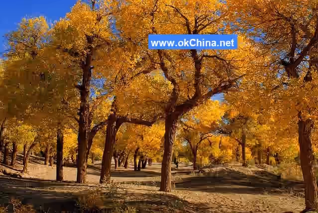
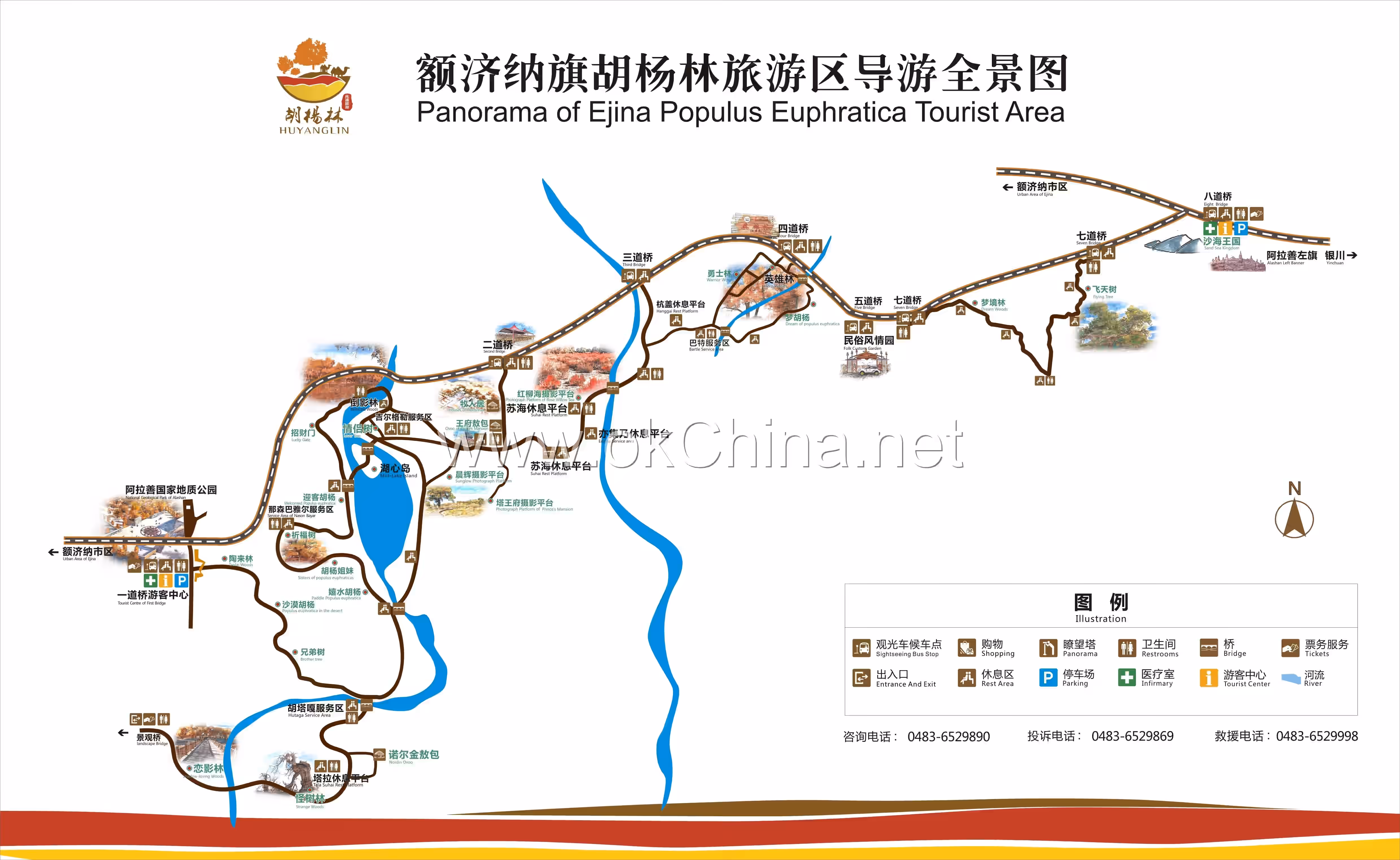
The tourist area covers an area of 54,000 mu and consists of four scenic spots: the Taolai Forest at the First Bridge, the Reflection Forest at the Second Bridge, the Tamarisk Sea at the Third Bridge, and the Hero Forest at the Fourth Bridge. It integrates ecological sightseeing, science education, cultural experiences, leisure entertainment, and themed vacations. The area boasts the world's largest, most ancient (with numerous thousand-year-old trees), and most spectacular pristine Populus euphratica forest sea. It is a national nature reserve, a national forest park, and an important component of the Alxa Desert UNESCO Global Geopark.
2. Orientation and Layout
2.1 Geographic Location
The Inner Mongolia Ejin Populus Euphratica National Nature Reserve is located in the center of Ejin Banner—the Ejin Oasis. It borders Dalaihubu Town, the seat of the Ejin Banner government, to the west and faces the Juyan Lake to the north. Its geographic coordinates are 101°03′–101°17′ east longitude and 41°30′–42°07′ north latitude. It is a wild plant-type nature reserve. The total area of the reserve is 26,253 hectares, with a core zone of 8,774 hectares, a buffer zone of 10,018 hectares, and an experimental zone of 7,461 hectares.
2.2 Geology and Geomorphology
The reserve is situated in the center of Ejin Banner, geologically belonging to the Tianshan-Yinshan geosyncline. The terrain is fan-shaped, generally higher in the southwest and lower in the northeast, with a relatively flat central area. Based on landform and material composition, it is primarily divided into alluvial plains and partially wind-deposited semi-fixed and fixed sand dunes, as well as Gobi desert landforms. Most of the area has an elevation between 850m and 950m, with an average elevation of about 900m.
2.3 Climate
Ejin Banner experiences cold winters and hot summers with significant temperature variations and ample sunshine. The annual average temperature is 8.3°C. The average temperature in January is -12.5°C, and in July it is 26.3°C. The extreme high temperature is 42.2°C, and the extreme low is -37.6°C. The annual average precipitation ranges from 37.9mm to 49.3mm, while the annual evaporation far exceeds the precipitation. Due to its proximity to desert areas, the region is prone to sandstorms. From late autumn to early summer of the following year, northwesterly winds prevail, with an average of 21 dusty days per windy month. Strong winds are common in winter and spring, often accompanied by cold waves.
3. Scenic Spot Introduction
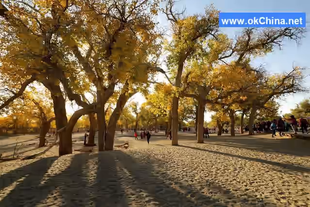
3.1 First Bridge
Upon entering the scenic area, the first sight is the Lianying Forest at the First Bridge viewing area. Here, Populus euphratica trees, wetlands, desert, and pastoral life blend into a unique natural landscape.
This area is home to the largest Oboo (sacred stone mound) of the Wulangerile Gacha. When visitors pass by, hospitable Mongolian people offer sacred hada scarves as blessings. Visitors can experience Mongolian customs and feel the romance and tenderness here. Beside the Oboo, a beautiful feast unfolds: the magnificent and magical Populus euphratica forest stands tall and proud, creating a breathtaking scene that represents a pristine, harmonious homeland where heaven and earth unite.
3.2 Second Bridge
The Second Bridge retains a more primitive appearance, with wide waterways dotted by sporadic Mongolian yurts and rolling sand dunes, making it an excellent location for photography enthusiasts.
In the clear autumn water, golden Populus euphratica trees are reflected, complementing the azure sky and creating increasingly enchanting colors. Although the trees here are not as robust and powerful as those at the Fourth Bridge, the presence of water lends them a unique, gentle beauty.
3.3 Third Bridge
Ejin is not only about Populus euphratica; the tamarisks at the Third Bridge are also extremely lush. As far as the eye can see, the area is covered in a rose-red hue, earning it the reputation as the "Tamarisk Sea."
As a common plateau plant, tamarisks are not as tall as Populus euphratica, but their beauty is equally noteworthy. Through the camera lens, red and yellow intertwine, reflecting a colorful world.
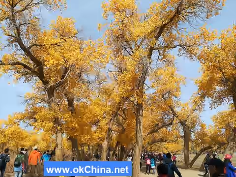
3.4 Fourth Bridge
The iconic scene from the movie Hero, where Flying Snow and Moon, dressed in red, engage in a graceful fight amidst a flurry of golden Populus euphratica leaves, was filmed at the Fourth Bridge. Consequently, the Populus euphratica forest here is also known as the "Hero Forest."
The Populus euphratica trees at the Fourth Bridge have thick trunks, strong branches, and diverse, captivating shapes. The forest grows luxuriantly; viewed from above, it resembles a golden sea, filled with brilliant autumn colors that are dazzling and intoxicating. Faced with such beauty, photography enthusiasts can only capture these fleeting moments with the click of their shutters.
The Populus euphratica forest at the Fourth Bridge grows on saline-alkali desert land, forming a completely naturally grown forest area. The strong desert atmosphere is truly admirable.
3.5 Fifth Bridge
In addition to natural scenery, the Fifth Bridge is rich in folk culture. Visitors can taste local delicacies, admire ethnic costumes, and purchase local specialty stones, each item being irresistible.
3.6 Sixth Bridge
As far as the eye can see, the Sixth Bridge features vast, boundless expanses of Populus euphratica leaves. Occasionally, one might spot rugged Mongolians riding tall camels through the area or the dust kicked up by passing sheep flocks dancing in the light and shadows.
3.7 Seventh Bridge
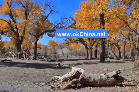
The Seventh Bridge is the place that awakens the thousand-year-old life of the Populus euphratica. During the golden autumn season, it becomes the starting point where the Populus euphratica displays its brilliant vitality.
The ground is covered with dead branches and withered Populus euphratica trunks. The trees here are tall with unique and varied forms. Among them, the "Flying Apsaras Tree" resembles an elf of the Populus euphratica forest. Having cultivated for a thousand years, it attained enlightenment and soared into the sky, with long hair like a waterfall, fluttering robes, and swirling ribbons, creating an ethereal, fairyland-like scene.
3.8 Eighth Bridge
Ejin Banner is not only home to the romantic and charming Populus euphratica forest but also hosts the world's third-largest desert—the Badain Jaran Desert. The most famous desert landscape here is at the Eighth Bridge. Located on the northern edge of the Badain Jaran Desert, the Eighth Bridge offers not only the majestic grandeur of the desert sunrise and the绚丽 colors of the sunset glow but also allows visitors to appreciate up close the sublime意境 described in the famous line: "In the vast desert a lone smoke rises straight; Over the long river the setting sun is round."
4. Populus Euphratica Culture
Populus euphratica is a relic species from the ancient Tethys Sea, an ancient tree species surviving from the Tertiary period, having existed on Earth for over 60 million years. It successively appeared along the coasts of the ancient Tethys Sea, becoming an important component of small-leaved forests in mountain valleys. During the early and middle Quaternary period, Populus euphratica gradually evolved into the dominant constructive species of desert riparian forests. It is mainly distributed in southern Xinjiang, the western part of the Qaidam Basin, the Hexi Corridor, and other areas. Populus euphratica trees growing in China's Tarim Basin vigorously extend their roots as soon as they sprout. In extremely hot and arid environments, they can grow over 30 meters tall. As the trees begin to age, they gradually shed their top branches and trunks, eventually reducing to a height of three or four meters while remaining lush and leafy until they die and dry out, yet still standing upright. In Ejin Banner, people praise the Populus euphratica with the saying: "It lives for a thousand years without dying, stands for a thousand years after death without falling, and remains不朽 for a thousand years after falling—three thousand years for the Populus euphratica, embodying a hundred million years of history." Its unyielding spirit is forged over millennia and celebrated for eternity. Populus euphratica was once widely distributed in the temperate and warm temperate zones of western China. Fossils have been discovered in the Kizil Caves in Kuqa, Xinjiang; the Tiejianggou area in Dunhuang, Gansu; and Pinglong, Shanxi, proving it is a Tertiary relict plant with a history of at least 65 million years. Today, apart from small amounts found along some rivers flowing into the desert in the Qaidam Basin, Hexi Corridor, and Alxa, Inner Mongolia, over 90% of China's Populus euphratica forest area is confined to Xinjiang, with 90% of that concentrated in the Tarim Basin of southern Xinjiang—a region known as the "extremely arid desert." Fossils of Populus euphratica have been found in the middle Paleocene strata of the Kizil Caves in Kuqa and Tiejianggou in Dunhuang, dating back at least 65 million years. Both the Book of the Later Han: Chronicles of the Western Regions and the Commentary on the Water Classic record the presence of "Hu Tong" (Wutong, referring to Populus euphratica) in the Tarim Basin. In the Uyghur language, Populus euphratica is called "Tokrak," meaning "the most beautiful tree." Due to its astonishing ability to resist drought, withstand wind and sand, and tolerate salinity and alkalinity, allowing it to survive and thrive tenaciously in the desert, it is praised as the "hero tree of the desert." During the Western Han Dynasty, the coverage of Populus euphratica in Loulan was at least 40% or more, and people relied on it for food, shelter, and transportation. Even in the Qing Dynasty, it was recorded that "Hu Tong (i.e., Populus euphratica) filled the wilderness, forming deep forests." However, within the short span of 20 years from the mid-1950s to the mid-1970s, the area of Populus euphratica forests in the Tarim Basin sharply decreased from 520,000 hectares to 350,000 hectares, a reduction of nearly one-third. In the lower reaches of the Tarim River, the Populus euphratica forest area plummeted by 70%. Among the surviving forests, a significant portion consists of degraded stands. The primary cause of this outcome has been unsustainable human socio-economic activities. The demise of Populus euphratica and its understory vegetation has turned the middle and lower reaches of the Tarim River into one of the two major source areas for sandstorms in Xinjiang.### 4.1 Protection Measures The vast majority of the world's Euphrates poplars grow in China, and over 90% of China's Euphrates poplars are found in the Tarim River Basin of Xinjiang. The area of the Euphrates Poplar Reserve in the Tarim Basin alone reaches 3,800 square kilometers. The Euphrates poplar forests in the basin account for three-quarters of China's total original Euphrates poplar forest area and have been rated as "China's Tarim Euphrates Poplar Hometown" by the China Specialty Hometown Recommendation and Publicity Committee. In 2008, a contiguous, high-density area of 1,987,900 mu of Euphrates poplar forest in the south of Shaya County was awarded the title of "Largest Area of Original Ecological Euphrates Poplar Forest" by the Shanghai Guinness World Records. The Euphrates poplar forests also serve as excellent seasonal pastures and habitats for wildlife. Due to the reduction of water flow in the lower reaches of the Tarim River, hundreds of miles of Euphrates poplar forests have fallen due to thirst. Although Euphrates poplars have extremely strong vitality, they cannot escape the disaster of long-term water scarcity. These millennia-old poplars cannot live to 100 years, exhausting their tears in the sandy sea. On April 5, 2006, the Euphrates poplar growth area in Xinjiang's Tarim region was approved by the State Council as a national-level nature reserve. Inappropriate logging, deforestation for land reclamation, or grazing have caused damage to Euphrates poplar forest resources and land erosion or sand accumulation, leading to intensified desertification. People have learned from these setbacks and have begun actions to save the Tarim River and the Euphrates poplar forests. Emergency water transfers to the lower reaches of the Tarim River have shown initial success, and the Euphrates poplar forests on both banks have begun to recover. The Tarim Euphrates Poplar Forest Reserve, covering nearly 390,000 hectares, has been upgraded to a national-level nature reserve. The Luntai Euphrates Poplar Park has been upgraded to a national forest park; the midstream wetlands of the Tarim River, dominated by Euphrates poplar forests, have attracted attention from international organizations and are listed as key protection targets. A Euphrates poplar forest nature reserve has been established in the desert arid area of Yuli County, Xinjiang. The Ejina Euphrates Poplar Forest Area is one of only three remaining in the world and is the most well-preserved. Hundreds of years old Euphrates poplars still thrive with lush branches and leaves, showcasing the charm of the vast desert, a miracle favored by nature. Not only does it offer the majestic beauty of the desert sunrise and the brilliant colors of the sunset glow, but it also allows one to experience up close the exquisite意境 of "a lone smoke rises straight in the vast desert, the long river sets with the round sun."
5. Nearby Scenic Areas
5.1 Juyan Lake
Located 40 kilometers north of Dalaihubu Town in Ejina Banner. Juyan Lake is a natural lake formed by the inflow of the Heihe River originating from the Qilian Mountains. It is divided into eastern and western lakes, with a water area of about 300 square kilometers.
"Juyan" is a Xiongnu term, interpreted in the Commentary on the Waterways Classic as "weak water flowing sand." It was called Juyan Marsh during the Han Dynasty, West Sea during the Wei and Jin periods, and has been known as Juyan Lake since the Tang Dynasty. Located in the northern part of Ejina Banner, Alxa League, Inner Mongolia Autonomous Region, it is long and narrow, curved like a crescent moon. The Ejina River flows into the lake, serving as its main water source. The lake surface has shifted over time due to changes in the Ejina River's course, gradually silting up. After the Yuan Dynasty, it split into three lakes: Yijinai, Habanhabaer, and Talashi. Since the Qing Dynasty, it has been divided into the eastern Suonuo'er (Mongolian for "doe lake") and the western Gashunuo'er (Mongolian for "bitter lake"), about 35 kilometers apart. However, in recent years, due to reduced water inflow from the main source, the Ejina River, Juyan Lake has dried up. Historically, Juyan Lake had abundant water, with beautiful grasslands, fertile land, and lush pastures along its shores. It was one of China's earliest agricultural reclamation areas, with farming history dating back to the Han Dynasty. It was also an important passage through the Badain Jaran Desert and the Gobi to the northern deserts, a strategic location contested by military forces. Records of the Grand Historian: Treatise on the Xiongnu records: "(Han) sent the Commandant of Strong Crossbows, Lu Bode, to build a city on Juyan Marsh." Later, a commandery and county were established here. During the Northern and Southern Dynasties, the Rouran occupied the area; during the Sui and Tang, it belonged to the Turks; and during the Song Dynasty, it was under the rule of the Western Xia, serving as one of its political, economic, and cultural centers. In this oasis amidst the vast yellow sand, by the clear waters, many legends have been told and stories have unfolded. It is said that the Western Han generals Huo Qubing and Li Guang watered their horses at Juyan Marsh during campaigns against the Xiongnu. Wei Qing and Huo Qubing's expeditions against the Xiongnu also targeted the Juyan region. The strategic importance of the Juyan region lay in its abundant water source—it was a sea. If the Xiongnu could be driven out, the formidable nomadic people would be forced to migrate north to the next water and grassland, thereby relieving the threat to the Han Dynasty. It is said that during the Yuan Dynasty, the Italian Marco Polo also visited Juyan Lake. The great Tang poet Wang Wei once stopped by the lake and wrote the famous poem Frontier Song: "Outside Juyan city they hunt the pride of heaven, white grass reaches the sky where wild fires burn, at dusk clouds over the desert they drive their horses, on autumn plains they shoot vultures well."
5.2 Ejina River
It is China's second-largest inland river, originating from the eastern foothills of the Qilian Mountains in Qinghai Province. The main stream is 821 kilometers long, with a basin area of 142,900 square kilometers (of which the main stream system covers 116,000 square kilometers). The section above Yingluo Gorge is the upper reaches, with a river length of 303 kilometers and a basin area of 10,000 square kilometers. The average annual precipitation is 350 millimeters, vegetation is relatively good, and it is the grain-producing area of the Ejina River Basin. The section from Yingluo Gorge to Zhengyi Gorge is the middle reaches, with a river length of 185 kilometers and a basin area of 25,600 square kilometers. The average annual precipitation is 140 millimeters, and the artificial irrigation oasis centered on the Zhangye region is large, making it a major grain-producing area of Gansu Province. The section from Zhengyi Gorge to the East and West Juyan Lakes in Ejina Banner is the lower reaches, with a river length of 333 kilometers and a basin area of 80,400 square kilometers. The average annual precipitation is 47 millimeters, and it is the key area for ecological protection and management in the Ejina River Basin.
"Ejina" is a phonetic transformation of the Tangut word "Yijinai," meaning black water or black river. However, late Qing scholar He Qiutao, when annotating Zhang Mu's Records of Mongolian Nomadic Pastures, cited Mr. Xu Xingbo, suggesting that "Ejina is a Mongolian word, meaning hidden or secluded." The Ejina River was historically called Weak Water or Jianggu Water, among other names.
The Ejina River is frequently recorded in historical texts, and the modern Ejina Banner Annals also records: "The Ejina River flows 250 kilometers within the banner, with an average width of about 150 meters, normal water level around 1.5 meters, average flow between 200–300 cubic meters per second. It branches into 19 tributaries on the triangular oasis from south to north... The remaining flow feeds into the East (Subo Nur), West (Gashun Nur) Juyan Lakes and Jingsitu Lake."
5.3 Heishui Ancient City Ruins
The most complete existing ancient city on the "Silk Road" — Heicheng
The setting sun like blood, desert winds singing, beacon fires and wolf smoke, messages sent by feather arrows. Stroking the ruins under the veil of dusk, heavy thoughts slip through the fingers, disappearing into the wordless weight of history. The ancient path winds, flute sounds mournful; facing the Euphrates poplar forest, tears fall silently...
"Juyan" is a Xiongnu word meaning "heaven." The Juyan region was originally Xiongnu pastureland. After the 19-year-old Han general Huo Qubing defeated the Xiongnu, the Han Dynasty stationed troops here to guard the frontier, creating a splendid Han civilization in the Juyan region. After the Han, civilization here was intermittent and fluctuating, with the scars of war soaking the banks of the Weak Water.
By 1038 AD, the Western Xia state established by the Tangut people set up the "Weifu Military Commission" here, marking another peak of Juyan civilization and the reason it provides important clues for modern Western Xia cultural research. In 1226, Genghis Khan's Mongol army captured Heicheng during their fourth southern expedition. In 1286, Kublai Khan established the "Yijinai Route Chief Administration" here, making it a transportation hub from the Central Plains to the northern deserts. Marco Polo traveled along this ancient path into the Eastern paradise.
In 1372, after Ming Dynasty General Feng Sheng captured Heicheng, the Ming abandoned the region. Thereafter, Heicheng slept in the dust-sealed history for nearly 700 years. In 1886, Russian scholar Grigory Potanin discovered Heicheng during an expedition in Ejina. In April 1908, Russian explorer Pyotr Kozlov excavated a large number of Western Xia artifacts here, including precious bilingual Chinese-Tangut dictionaries like Fan Han He Shi Zhang Zhong Zhu, Yin Tong, and Wen Hai. This major archaeological discovery and act of plunder caused a sensation in archaeological and historical circles...
Heicheng is rectangular in plan, with a perimeter of about 1 kilometer, 434 meters east-west, and 384 meters north-south. Gates are set in the middle of the two walls with added barbicans. The city walls are built of rammed earth, with remaining heights of about 9 meters. A stupa-style Lamaist pagoda stands at the northwest corner. The original streets and main buildings are faintly discernible, and the remnants of ancient river channels and farmland around still retain their outlines. The desert is nearly swallowing this place. How many treasures are still buried in Heicheng remains an unsolved mystery, but the reflections it brings to humanity should by no means be limited to treasures...
Comments
Post a Comment