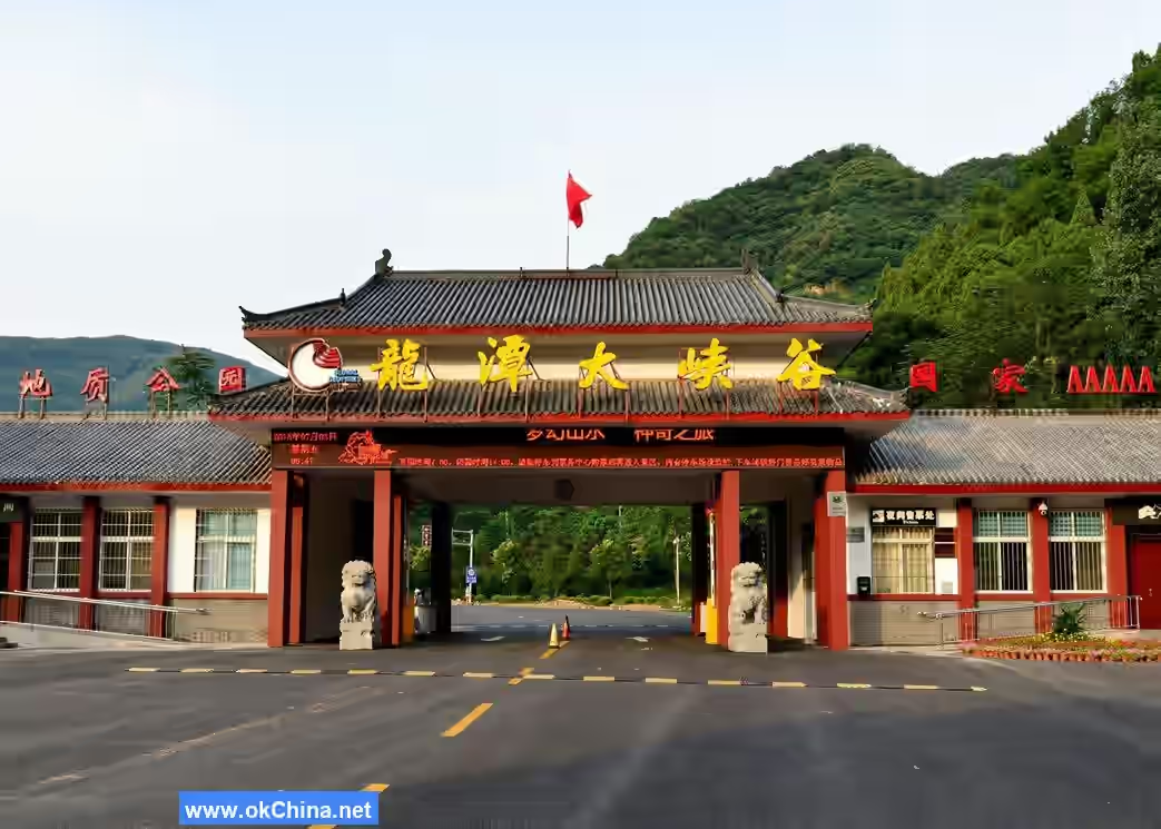
Longtan Grand Canyon Scenic Area in Luoyang
1. Introduction
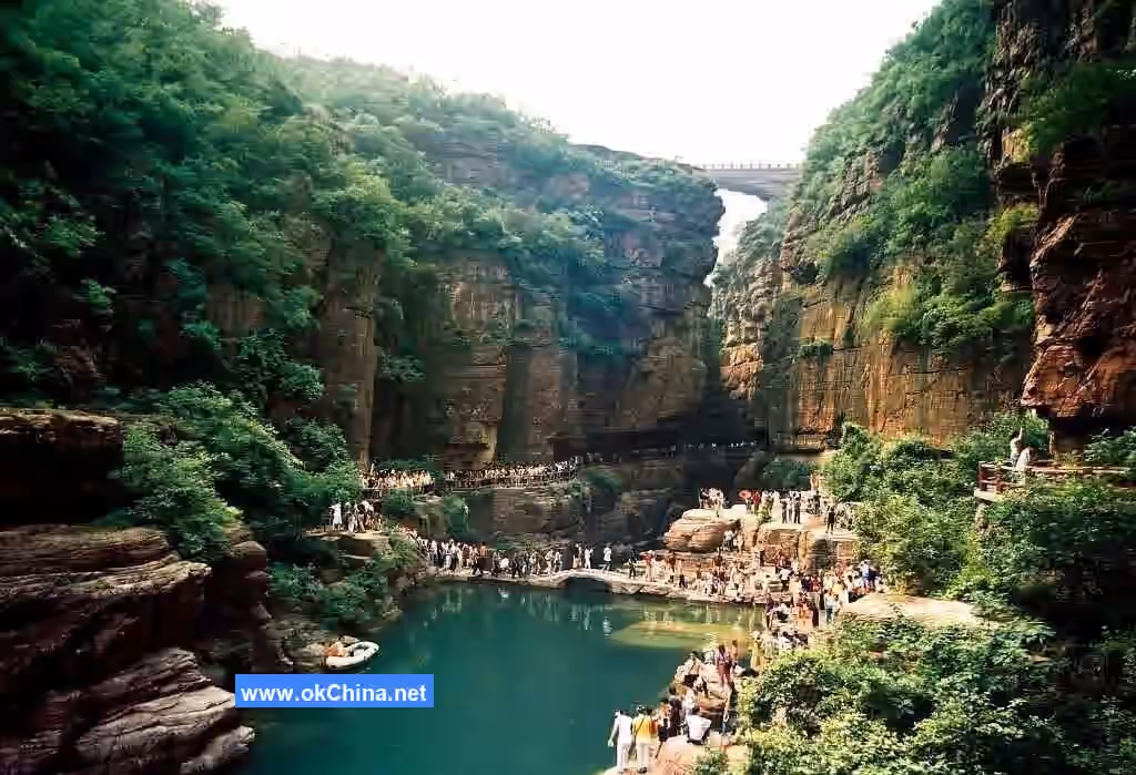
The Longtan Grand Canyon Scenic Area in Luoyang is located in Shijing Town, northern Xin'an County, Luoyang City, Henan Province. It is a U-shaped canyon formed by flowing water eroding and cutting through purplish-red quartz sandstone. The Longtan Grand Canyon in Luoyang stretches for 12 kilometers and is a comprehensive eco-tourism destination integrating ecological canyon tourism, leisure vacation tourism, and modern agricultural tourism.
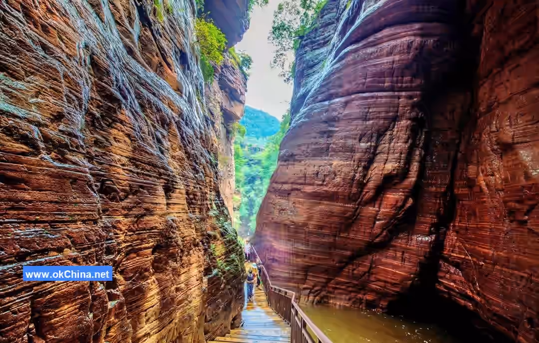
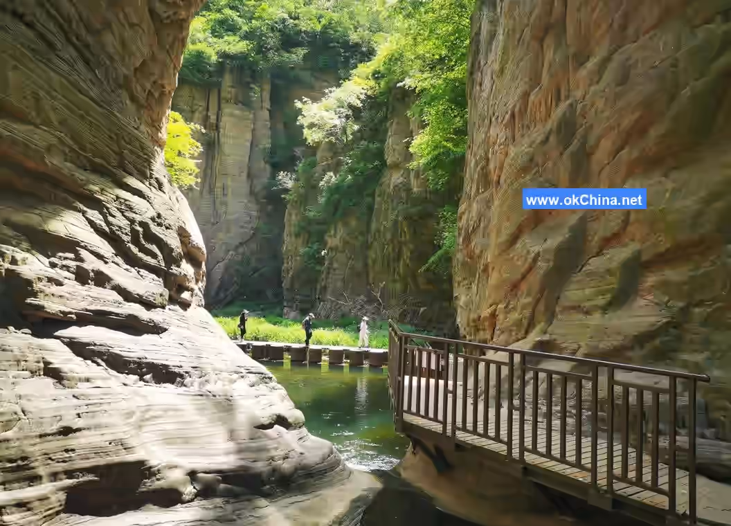
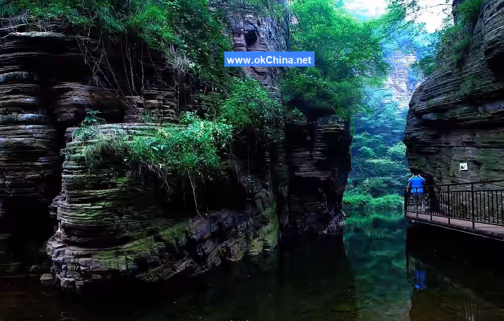
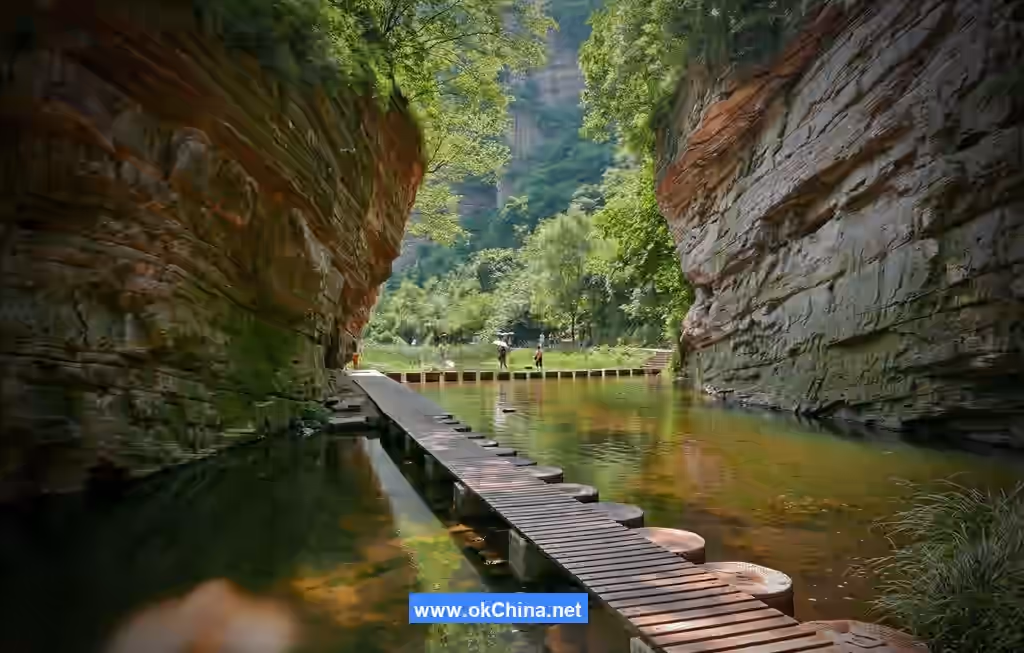
The depth of the Longtan Grand Canyon in Luoyang ranges from 300 to 500 meters, with the narrowest point being only 1–3 meters wide. Different sections of the grand canyon exhibit various forms, including gorge valleys, cliff valleys, canyons, and broad valleys. The area experiences a northern temperate continental monsoon climate, characterized by cold, dry winters and hot, rainy summers. The scenic area primarily formed during the crustal movement period 1.2 billion years ago. Due to the uplift and subsidence, collapse, and long-term erosion by water and wind of the purplish-red quartz sandstone, the unique red rock cliff valley group landform was created here. The scenic area's elevation ranges between 700 and 1000 meters, with higher terrain in the northwest and lower in the southeast. Major attractions include the Daimeishan Geological Museum, Five Dragon Pools, Wenggu (Urn Valley), Water Flowing Uphill, Black Water Pool, and others. From the outside in and from east to west, the scenic area can be divided into the Pastoral Eco-Tourism Zone, Modern Leisure Vacation Zone, Tourist Service Functional Zone, and Core Eco-Tourism Zone.
2. Geographical Environment
2.1 Location and Territory
The Longtan Grand Canyon Scenic Area in Luoyang is situated in Shijing Town, northern Xin'an County, Luoyang City, Henan Province, between 111°53′–112°19′ east longitude and 34°36′–35°05′ north latitude. Backed by Luoyang, it is 180 kilometers from the provincial capital Zhengzhou. The Lianhuo Expressway, National Highway 310, and Longhai Railway run east-west across the county. Provincial Highway S246 passes through the county town directly to the scenic area, which is 70 kilometers from Luoyang.
2.2 Climate Characteristics
The Longtan Grand Canyon Scenic Area in Luoyang is located in the transitional zone between the Loess Plateau and the North China Plain, experiencing a northern temperate continental monsoon climate with cold, dry winters and hot, rainy summers.
2.3 Topography and Landforms
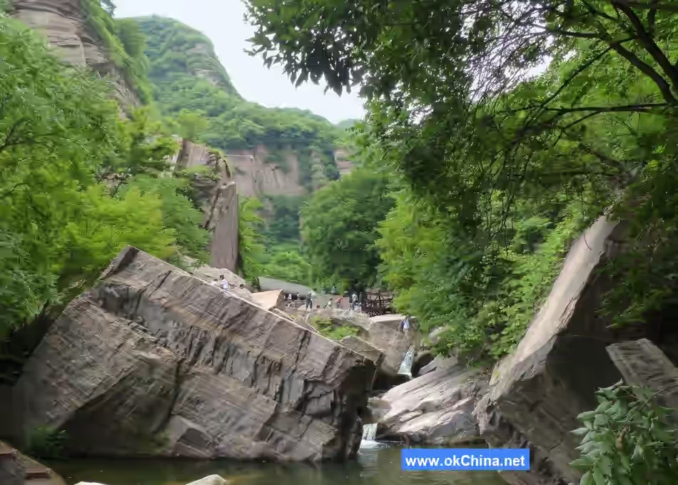
The Longtan Grand Canyon Scenic Area in Luoyang, formed during the crustal movement period 1.2 billion years ago, underwent 1 billion years of geological sedimentation and 2.6 million years of water erosion and rotational corrosion, creating its unique purplish-red quartz sandstone landscape. This forms the red rock cliff valley group landform, characterized by high gorges, long valleys, mountain cliffs, and rock caves. It stretches 12 kilometers in length, with a depth of 300–500 meters and the narrowest point being only 1–3 meters wide. Located in the mountainous area of western Henan, at the boundary between the second and third topographic steps and the convergence of the eastern extension of the Qinling Mountains and the southern extension of the Taihang Mountains, the terrain is higher in the northwest and lower in the southeast. The elevation ranges from 700 to 1000 meters, with an average elevation of about 800 meters and a maximum elevation of 1384.7 meters.
2.4 Geology
During the Mesoproterozoic era 1.2 billion years ago, the North China region was an ancient ocean. Crustal movements caused the uplift of the seabed sedimentary layers, exposing them above ground and forming an over 820-meter-thick layer of purplish-red quartz sandstone on the southern bank of the Yellow River in northern Xin'an. This constitutes the main body of the mountains in this northern part of Xin'an County. After 1 billion years of geological sedimentation and 2.6 million years of water erosion and rotational corrosion, the scenic area's unique canyon landscape was formed.
2.5 Hydrology
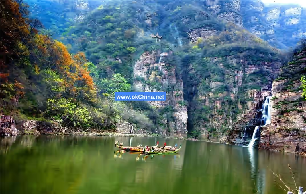
The Longtan Grand Canyon is located in the upper reaches of the Qing River, a tributary of the Yellow River. It is 12 kilometers long, 100–300 meters deep, and the narrowest point is only about 1–3 meters wide. The Qing River, a tributary of the Yellow River, originates from the northern foothills of Qingyao Mountain (the secret capital of the Yellow Emperor), flows through the Longtan Grand Canyon, converges with Shanwo River in front of Honghai'er Mountain, and empties into the Xiaolangdi Reservoir. It is 24 kilometers long with a drainage area of 138 square kilometers. During flash floods, the maximum flow rate can reach 450 cubic meters per hour.
2.6 Biodiversity
The Longtan Grand Canyon Scenic Area in Luoyang is rich in biological species, with vegetation coverage exceeding 90%, providing a habitat for wildlife, including nationally protected animals such as macaques, giant pandas, and sika deer.
3. Main Attractions
Scenic Area Layout
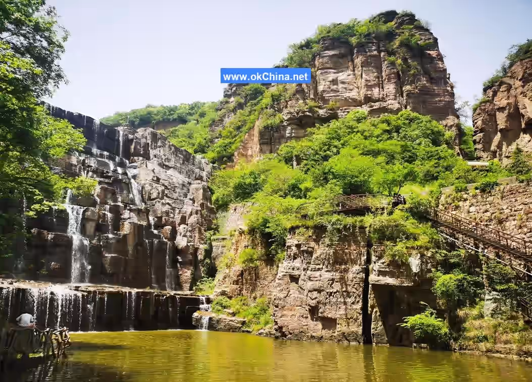
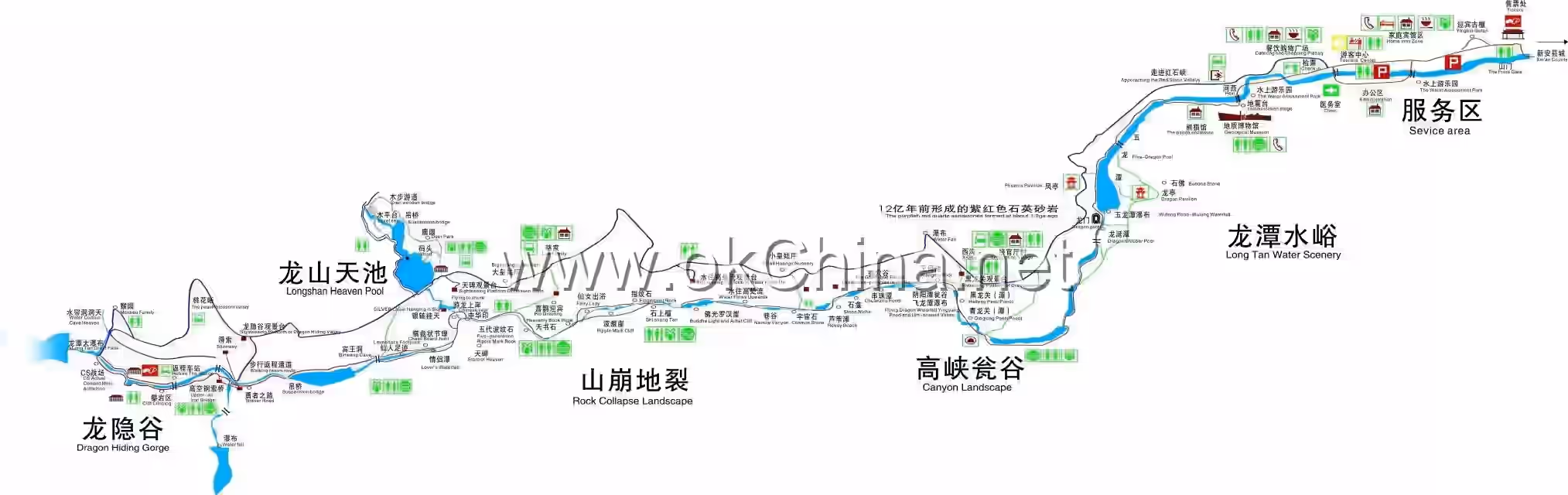
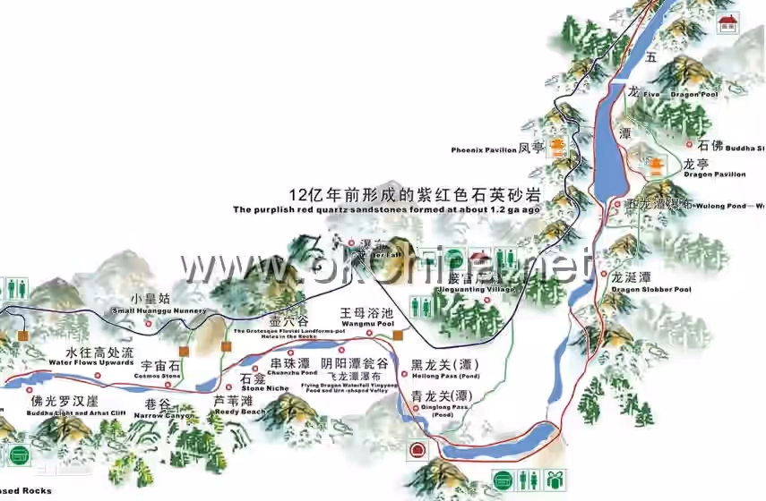
Longtan Grand Canyon features the Daimeishan Geological Museum, Five Dragon Pools, Wenggu (Urn Valley), Water Flowing Uphill, Dragon Gate, Black Water Pool, Yin-Yang Pool, Stone Niche, Buddha Light Arhat Cliff, Five-Dynasty Ripple Stone, Heavenly Stele, and Longshan Heavenly Pool. The scenic area is a comprehensive eco-tourism destination integrating modern agricultural tourism, core ecological canyon tourism, and leisure vacation tourism. From the outside in and from east to west, it can be divided into the Pastoral Eco-Tourism Zone, Modern Leisure Vacation Zone, Tourist Service Functional Zone, and Core Eco-Tourism Zone.
3.1 Daimeishan Geological Museum
The Daimeishan Geological Museum was completed in 2008. The main building covers an area of approximately 2000 square meters and consists of four parts: the Management Center, Information Center, Exhibition Center, and Service Center. The Exhibition Center, covering 1275 square meters, is the core part of the museum. The entire exhibition is based on the connection of the Yellow River, systematically reflecting various typical geological and geomorphic landscapes, primitive ecology, and rich Yellow River culture under the background of the Yellow River's connection.
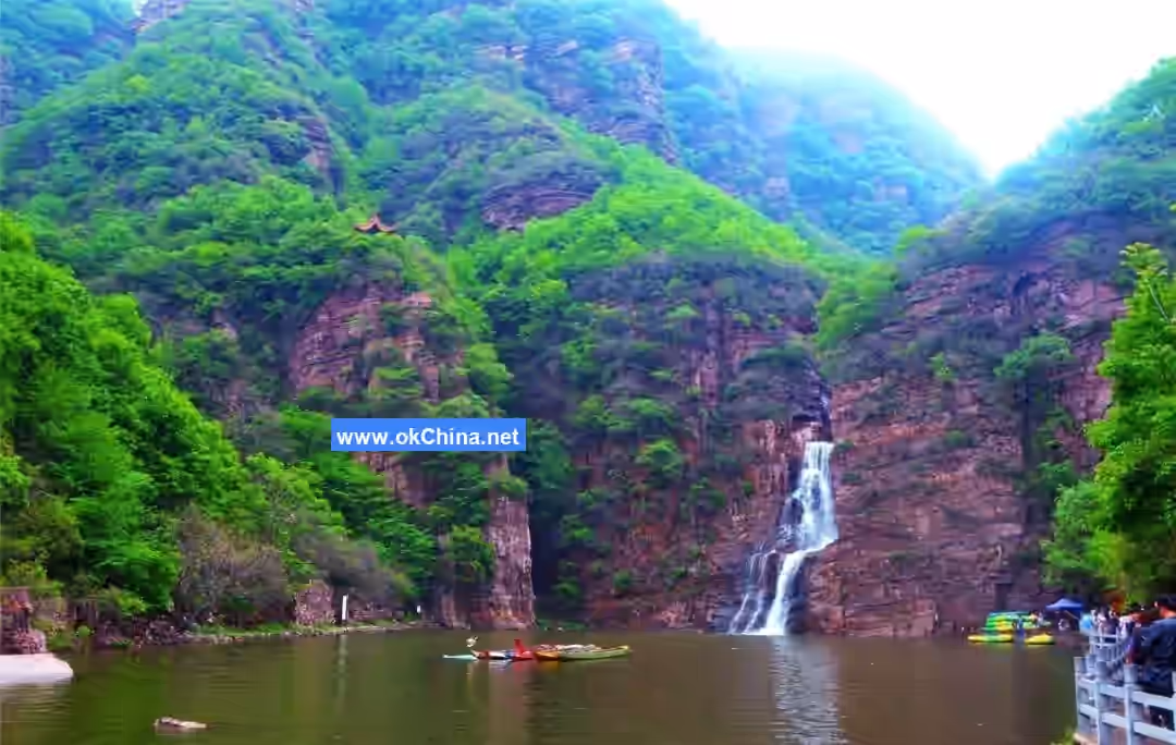
3.2 Five Dragon Pools
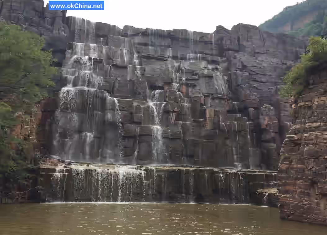
On the south bank, the Five Dragon Pools Waterfall falls from the mouth of a suspended gully on a sheer cliff. It is the source of the Five Dragon Pools, featuring deep pools and a high waterfall.
3.3 Wenggu (Urn Valley)
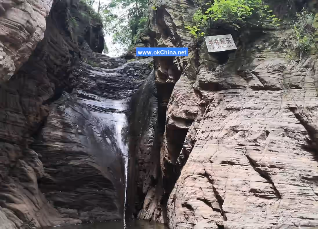
The Wenggu section is the most representative red rock cliff valley group landform in Longtan Grand Canyon. At the base of the red cliff walls on both sides of Longtan Canyon, there are many hemispherical stone niches formed by ancient marine sedimentary quartz sandstone after long-term water erosion and rotational corrosion. In the Feilong Gorge area, these hemispherical stone niches have been uplifted from the base of the cliff to the middle of the cliff wall, causing the entire gorge section to appear as curved opposing walls with a small opening and a large belly. Looking up, one feels as if inside an urn, hence the name "Wenggu" (Urn Valley). There are two Wenggu in Feilong Gorge. The first Wenggu has a diameter of 20 meters and an arc of 270 degrees. The second Wenggu was cut through by flowing water, eventually becoming a cliff valley. Heilongguan (Black Dragon Pass) is a gorge valley over 20 meters long and more than 50 meters deep, with the narrowest point allowing only one person to pass through.
3.4 Water Flowing Uphill
Water Flowing Uphill is one of the "natural mysteries" of Longtan Grand Canyon. In this section of the canyon, after the rock layers tilted, collapsed, and subsided, water erosion and downcutting proceeded from the lower to the upper layers of the rock strata at higher elevations. Therefore, the river naturally flows from the lower layer to the upper layer. The riverbed rock layers and the rock layers on both banks complement each other. When the river encounters a higher peak ahead, it sharply turns right, changing direction and creating a visual illusion as if the water is flowing from low to high. In reality, the water still flows from the higher part of the canyon to the lower part. Legend has it that there was a little white dragon in the Five Dragon Temple. One day, it transformed into a young man and entered the Longtan Grand Canyon. Later, it encountered a group of itinerant monks and asked them why they had come. The monks replied they were there to spread Buddhist teachings and complete their merits. The monks pointed to the upper part of the canyon and said, "There is a Buddha's light there. If a sincere Buddhist practitioner stands there, the Buddha's light will appear." The white dragon didn't believe it and made a bet with them, saying, "If you can make Buddha's light appear in this alley, I will make the river water flow uphill." As soon as the white dragon finished speaking, all the monks leaped up and stood on the high cliff, instantly shining with golden light. Seeing this, the white dragon said, "Master, I was impulsive. How could I make water flow uphill?" The monk replied, "As long as one is sincere in all matters, what is spoken can become reality. Now, look at your feet." The white dragon looked down and indeed saw the river water flowing from low to high.
3.5 Dragon Gate
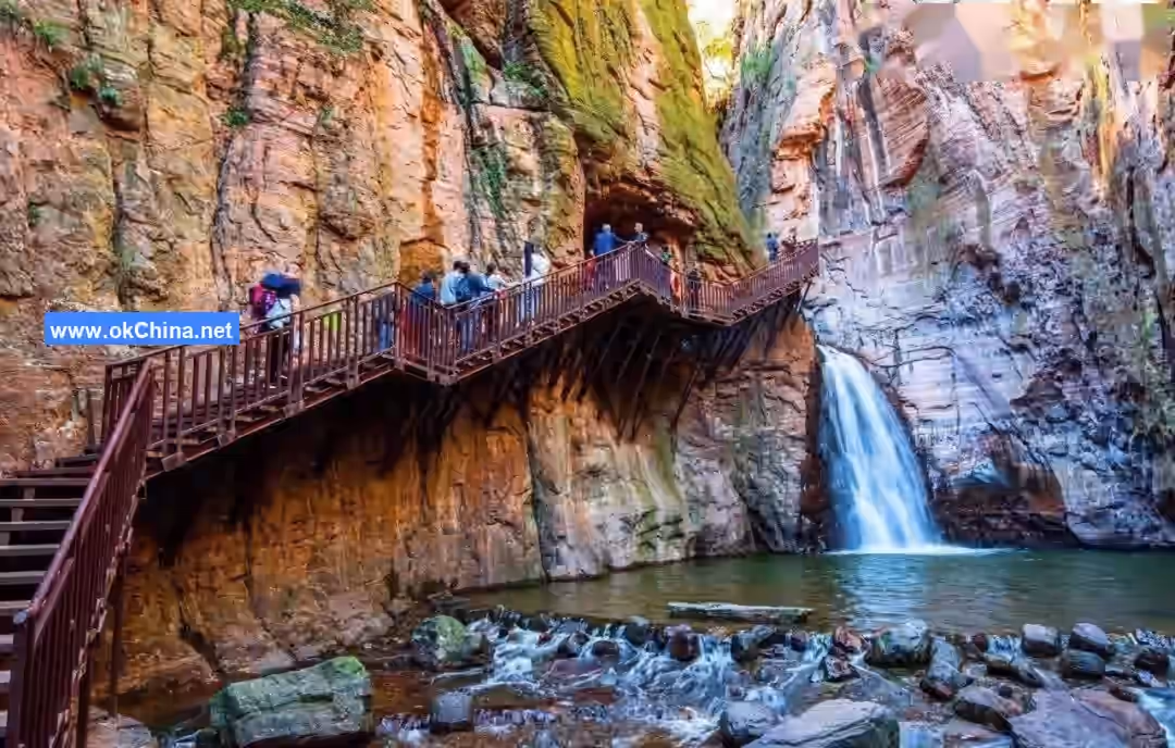
Passing the Five Dragon Pools and taking the plank road on the right side, which is narrow and built over the air, leads to the Dragon Gate Tunnel.
3.6 Black Water Pool
The cliffs on both sides of the Black Water Pool stand upright, with the valley width only 1–3 meters. Looking up, only a sliver of sky is visible, making it the narrowest point within the canyon. Water accumulates in the valley to form a pool, 4–5 meters deep. Because it is located in a deep valley and receives little sunlight, the water appears deep and dark, hence the name Heilongguan (Black Dragon Pass), and the pool is called Heilongtan (Black Dragon Pool).
3.7 Yin-Yang Pool
The Yin-Yang Pool consists of two connected water pools, resembling a gourd. The one located at the downstream valley mouth is larger, receives some sunlight, has shimmering water, and is called the Yang Pool (Sun Pool). The one upstream is smaller, the canyon narrows, it receives less sunlight, the water surface is dark, and it is called the Yin Pool (Shade Pool). Geomorphologically, it is also a type of pothole.
3.8 Stone Niche
The Stone Niche is a natural stone cave within a cliff, located about 10 meters above the water surface at the valley bottom. The cave is about 12 meters high, with a small top about 5 meters wide and a large belly about 15 meters wide. Crabapple trees grow at the cave bottom, and the surrounding cave walls are smooth. It is half of a pothole abandoned during the process of mountain uplift and water downcutting, developed within a cliff valley. Its surface is round, smooth, and brightly red.
3.9 Buddha Light Arhat Cliff
Looking from the left cliff wall of the Buddha Light Arhat Cliff, from top to bottom, arhats are arranged on the cliff wall in seven layers, numbering up to five hundred. The rock on the right resembles the Buddha, and Guanyin (Avalokitesvara) sits at a rock crevice on the left, forming a grand-scale ritual site. The rock layers where the arhats are arranged have a high quartz content, making the rock hard. When subjected to force, vertical tension joints easily form, dividing the rock layers into stone columns. These stone columns, after spheroidal weathering and rounding, resemble arhat figures when viewed from a distance.
3.10 Five-Dynasty Ripple Stone
On the surface of the Five-Dynasty Ripple Stone, five different types of ripple marks can be seen, each formed in five different geological eras, hence the name. They are wavy traces left on bedding planes when geological sediments migrated under the action of water or wind. Later, due to changes in the sedimentary environment, such as wind direction, water flow direction, shoreline direction, and micro-landform changes, several layers of ripples with different shapes and directions formed. It holds significant scientific reference value for studying the formation of sedimentary structures.### 3.11 Heavenly Stele The Heavenly Stele consists of two purplish-red slab-like giant rocks, standing tall by the Qinghe River like cranes in flight. The smaller one is approximately 40 meters high, while the larger one exceeds 50 meters. Towering and majestic, their grandeur is beyond human creation, hence the name "Heavenly Stele." Viewed from different angles, the stele resembles a soaring eagle, a flying bird, a ship's sail, the back of a knife, or a leaping carp.
3.12 Longshan Tianchi (Dragon Mountain Heavenly Pool)
On the return route of the scenic area lies a lake named Longshan Tianchi, one of the important water sources for the Longtan Grand Canyon. With a water area of 10 square kilometers, a depth of 20-30 meters, and a fjord extending about 1 kilometer, it presents a scene of expansive water and secluded gorge, where the sky appears as a narrow slit, forming the "Secret Realm of the Heavenly Pool."
4. Scenic Area Culture
4.1 Historical Legends
4.1.1 The Legend of the Dragon
In ancient times, at the dawn of the earth's formation, legend tells of five dragons—black, white, green, yellow, and red—who, due to their outstanding achievements, were granted by the Jade Emperor to rest in the mountains by the Yellow River at the foot of Jingzi Mountain. Among them, the red dragon had the most fiery temper. Once, after a quarrel, it left in a fit of anger. Beneath where it once lay, a winding, deep ravine was left behind. From a planar view, the Longtan Grand Canyon resembles a dragon lying east to west, and the "Legend of the Dragon" is widely circulated throughout the canyon.
4.1.2 The Mystery of Luo Binwang
During the Tang Dynasty, as Empress Wu Zetian's (624–December 16, 705) power grew, opponents began plotting resistance. In the ninth month of the first year of the Sizheng era (January 23, 684–February 27, 684), the Duke of Ying, Xu Jingye, raised an army in Yangzhou. Luo Binwang joined him and wrote "Call to Arms Against Wu Zhao for Xu Jingye." Later, Xu Jingye was beheaded by Wu Zetian, while Luo Binwang's whereabouts became a mystery, with various theories circulating. One account suggests that after fleeing, Luo Binwang eventually arrived at Longtan Gorge after much wandering and lived there in seclusion. Villages named Luoling, Luocun, and Luozhuang are found near Longtan Gorge, and many villagers with the surname Luo claim to be descendants of Luo Binwang residing there.
4.2 Festivals
4.2.1 Water-Splashing Carnival
On July 22, 2018, the Longtan Grand Canyon Scenic Area in Luoyang City held its first Water-Splashing Carnival. Hosted by the Longtan Grand Canyon Scenic Area and jointly organized by the brands Ctrip, Qunar, and Travel Best, the event featured watermelon-eating contests, beer-chugging competitions, milk-drinking contests, and water-splashing battles in succession. The activities lasted until August 31.
4.2.2 Starlight Tent Music Festival
From August 15 to 16, 2020, the inaugural Starlight Tent Music Festival of the Longtan Grand Canyon Scenic Area in Luoyang City opened, hosted by the Xin'an County Culture, Radio, Television, and Tourism Bureau.
Comments
Post a Comment