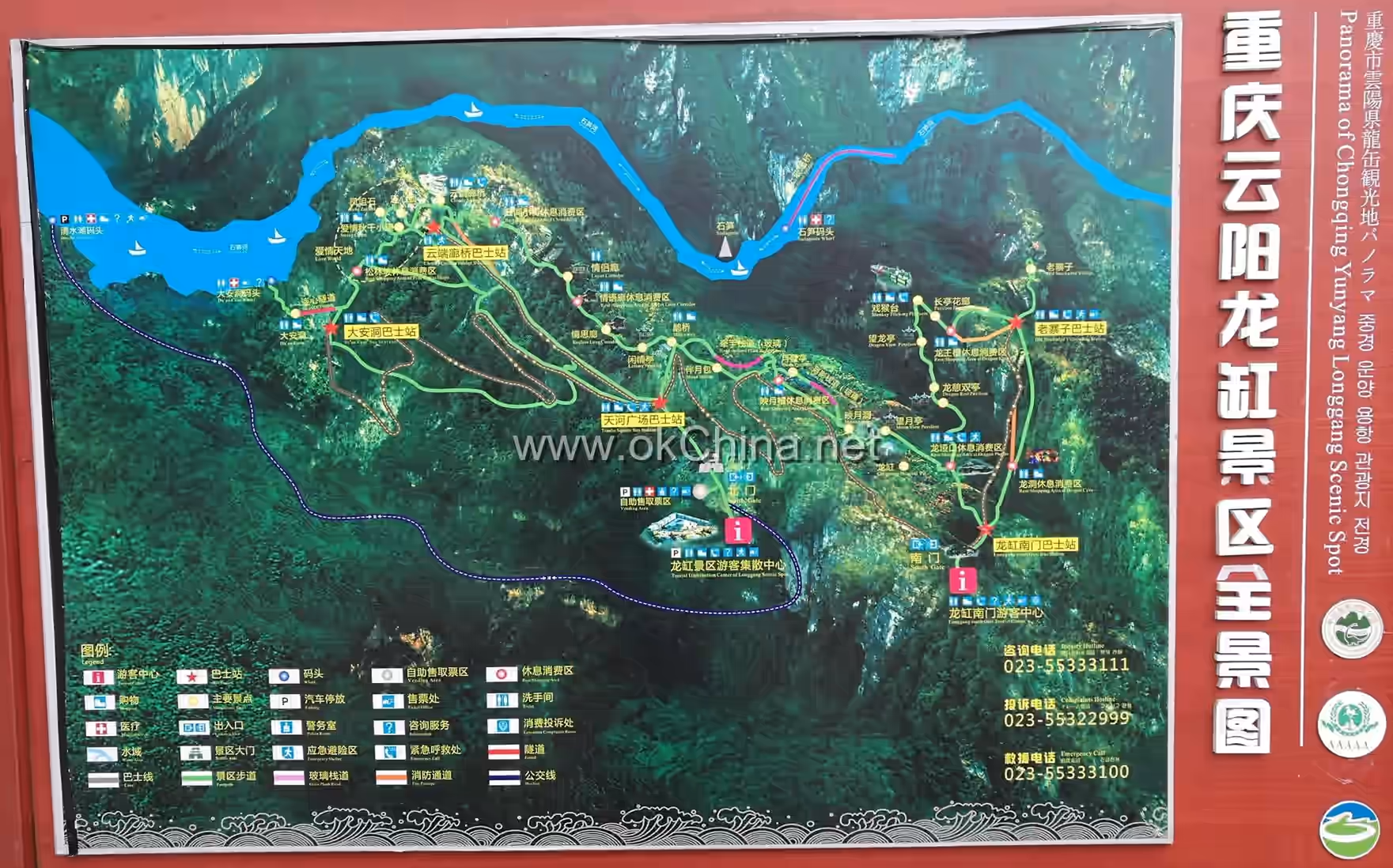
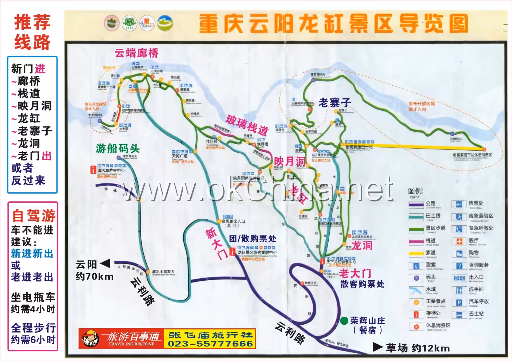
Longgang Scenic Area
1. Introduction
The Chongqing Yunyang Longgang Scenic Area is located within the territory of Qingshui Tujia Ethnic Township in the southeast of Yunyang County, Chongqing. It borders Wanzhou District to the southwest, Lichuan City in Hubei Province to the south, and Fengjie County to the east. It stretches from Hailuo Stream in Nixi Township in the west to Shisun River in the east, and reaches the outlet of Huangling Gorge in the north. The area is 37 kilometers long from north to south and 19 kilometers wide from east to west, encompassing the entire Qingshui Tujia Ethnic Township, Yaoling Township, Yanping Township, and parts of Biaocao Township and Nixi Township. It is 68 kilometers from Yunyang County town and 147 kilometers from the main urban area of Chongqing City. The total area is approximately 296 square kilometers. The scenic area centers around the world-rare Longgang Tiankeng (Dragon Vat Sinkhole), hailed as the "World's Number One Vat," with a depth of 335 meters. It also encompasses natural landscapes such as Shisun River, Qingshui Lake, and Longdong (Dragon Cave), integrating karst landforms, canyon scenery, karst cave wonders, and forest ecology. It is praised as the "Last Shangri-La of the Three Gorges of the Yangtze River" and "China's Most Primitive Ecological Scenic Area."
2. Geographical Environment
2.1 Location and Territory
The Longgang Scenic Area is located within the territory of Qingshui Tujia Ethnic Township in the southeast of Yunyang County, Chongqing. It borders Wanzhou District to the southwest, Lichuan City in Hubei Province to the south, and Fengjie County to the east. It stretches from Hailuo Stream in Nixi Township in the west to Shisun River in the east, and reaches the outlet of Huangling Gorge in the north.
2.2 Geology and Geomorphology
The Longgang Scenic Area is generally located within the fold belt between the Huaying Mountain major fault and the Qiyao Mountain major fault, specifically in the southeastern corner of the Eastern Sichuan Parallel Ridge-and-Valley Region. The structural layers before the Yanshanian period are in conformable and disconformable contact, with tectonic movements primarily characterized by significant uplift and subsidence. Folding structures were prominent in the late Yanshanian period, with the Upper Cretaceous showing unconformable contact with the underlying strata, and the structural style dominated by folding deformation. The area lies in the transitional zone between the Eastern Chongqing Fold Belt and the Hunan-Hubei-Sichuan-Guizhou Uplift Fold Belt, forming part of the thin-skinned tectonics resulting from the Indosinian-Himalayan movements. It is mainly characterized by a compartmentalized structure formed by broad, flat box (drawer)-shaped synclines and sharp, narrow anticlines. At the anticlinal axes, stress concentration easily forms joints, fissures, or compressional-shear faults of varying scales. The scenic area is dominated by typical karst landforms, shaped by the combined effects of karst processes, gravitational collapse, and fluvial erosion, resulting in diverse geomorphic landscapes and peculiar peaks and rocks. Longgang formed at a fracture zone where three sets of joints intersect with the cleavage at the northeastern turning end of the Yaoling Syncline, later shaped by repeated dissolution-collapse cycles from groundwater in the karst caves.
2.3 Climatic Characteristics
The Longgang Scenic Area is located in a region influenced by monsoon cold currents. The climate is mild with abundant rainfall. Spring is dry, summer is hot, autumn and winter are often overcast with continuous rain. Sunshine is limited, humidity is high, and fog and clouds are frequent, but the frost-free period is long. The multi-year average temperature is coldest in January, ranging from 4 to 7 degrees Celsius; hottest in July and August, ranging from 30 to 32 degrees Celsius. The periods from April to May and September to October each year are characterized by continuous overcast and rainy weather. The annual distribution of precipitation shows a bimodal pattern. In winter, the southeastern Qiyao Mountain becomes the windward side for inland dry and cold air masses, leading to scarce precipitation under their control. In summer, influenced by the warm and moist air masses of the southwest monsoon, precipitation is more abundant.
3. Main Attractions
3.1 Longgang Tiankeng (Dragon Vat Sinkhole)
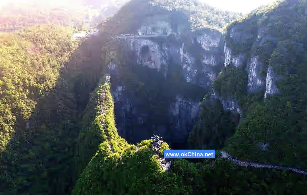
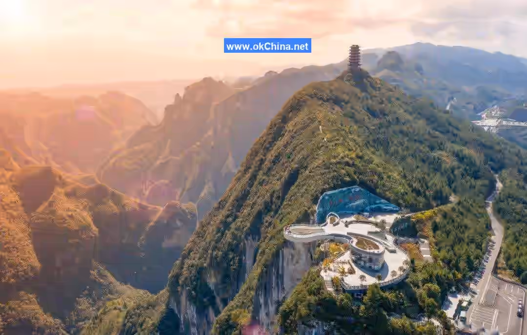
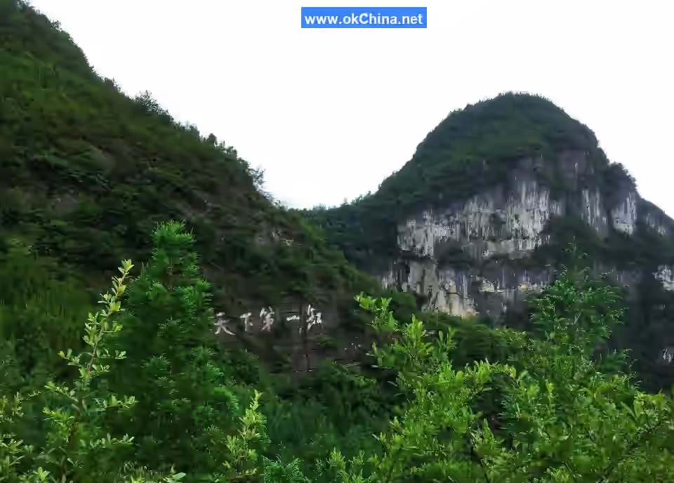
Longgang is an elliptical karst tiankend formed primarily by karst collapse and secondarily by dissolution. Legend says it was the bathing tub of the Little Dragon Maiden, hence the name "Dragon Vat." The altitude measured at Eagle Beak Peak, the lowest point on the rim, is 1113 meters. The long axis extends 304-325 meters in a direction of nearly 70 degrees, the short axis is 178-183 meters, and the depth exceeds 335 meters. Its depth ranks third in China (after Xiaozhai Tiankeng and Dashiwei Tiankeng) and fifth in the world. This giant funnel formed at a fracture zone where multiple sets of joints intersect with the cleavage at the northeastern turning end of the Yaoling Syncline, later shaped by repeated dissolution-collapse cycles from groundwater in the karst caves. It features enclosed, steep rock walls, presenting a karst landscape where both depth and planar width exceed one hundred meters. The inner walls are nearly vertical at 90 degrees, and the outer side of the vat is the steep cliff of Shisun River. The surroundings of Longgang are sheer cliffs and precipices, accessible only by narrow winding paths, the widest being just over 2 meters and the narrowest less than 0.4 meters. Standing on the rim, one side is the thousand-ren (ancient unit of height) vat wall, the other side is a bottomless abyss. Local villagers once descended to the bottom along the southern side and discovered an underground river developing there. The southeastern wall of the vat is relatively thin, with the thinnest part at Eagle Beak Peak being only 2-3 meters thick, extremely precipitous. According to the "Yunyang County Annals" from the 24th year of the Republic of China (1935), its form is straight up and down, resembling an incense burner, with purple smoke rising at times, also earning it the name "Furnace Vat." This area was once a primeval forest. Surface stone teeth, peak clusters, funnels, and a three-tier cave system formed independently. Three levels of karst caves can be observed on the vat walls: the first is called Wangyue Cave (Moon-Viewing Cave), the second is Yueya Cave (Moon Cliff Cave), and the third is the underground river at the vat bottom, which flows underground towards Shisun River. The vat floor reveals primeval forest, and the exterior is entirely covered by vegetation, with wild honeysuckle visible everywhere. Even the steep vat walls host tenacious plants, with pine branches lying across crevices and ancient vines hanging upside down. The jungle at the bottom is lush green, verdant throughout the seasons, with hundreds of birds singing and circling low. On rainy and foggy days, mist and clouds rise, creating a fairyland-like scene.
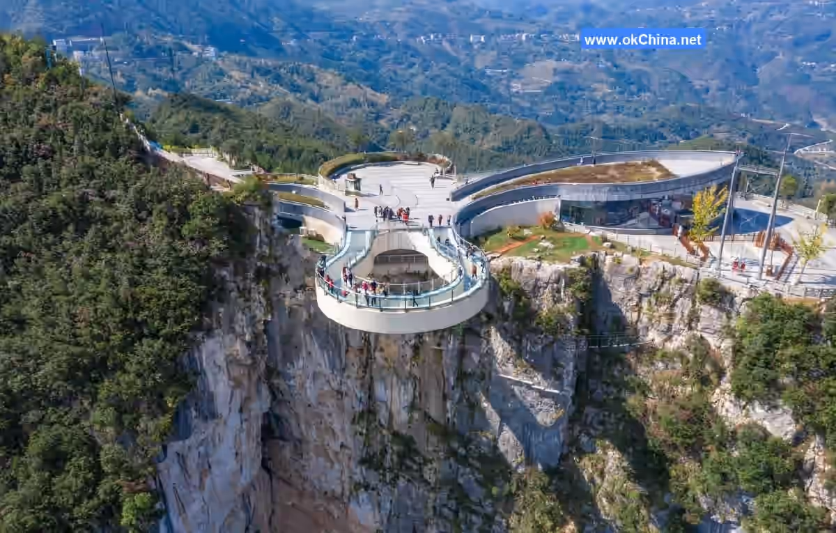
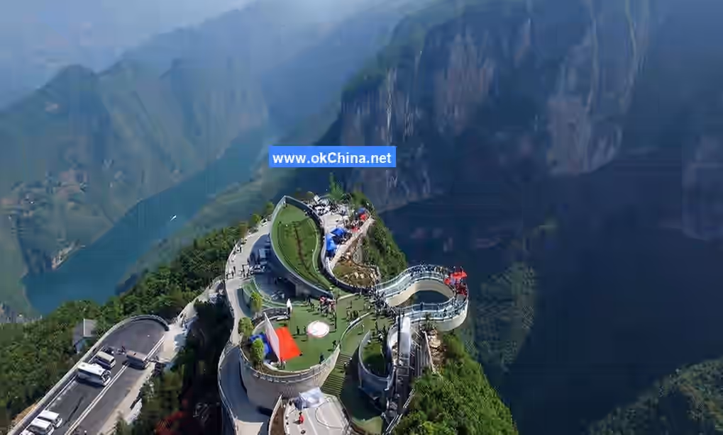
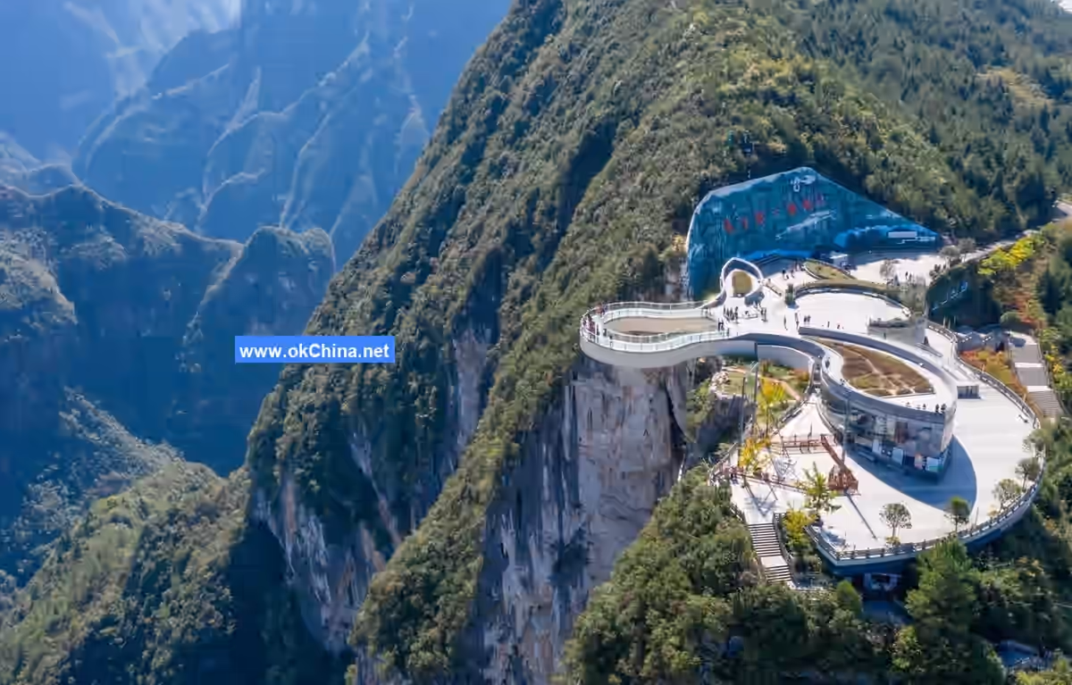
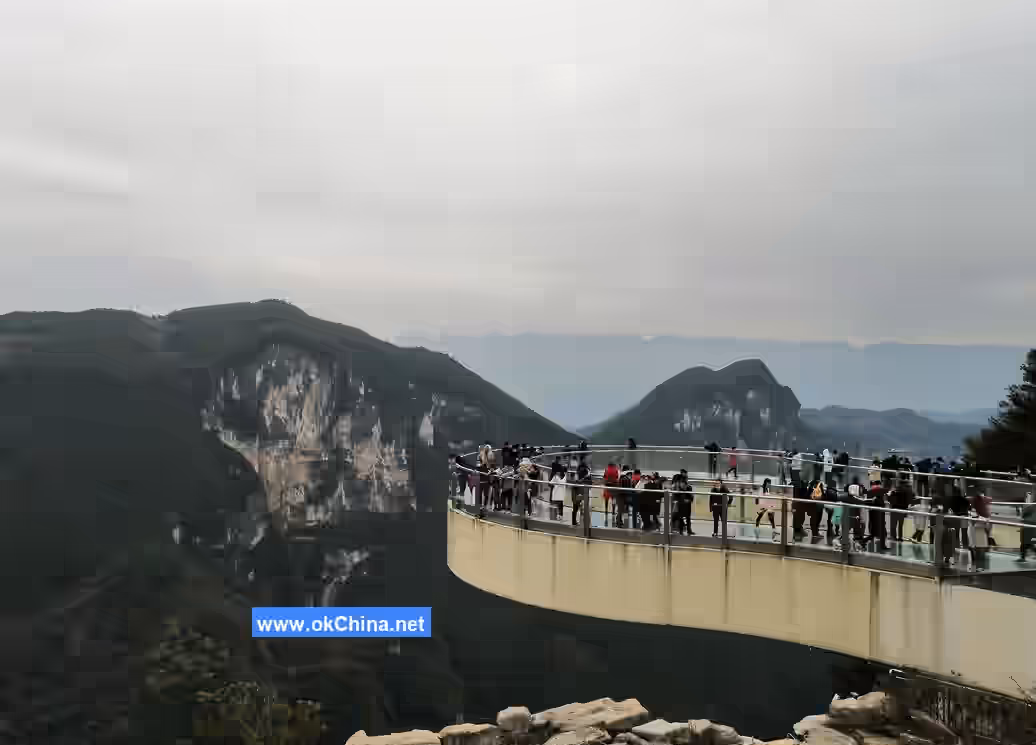
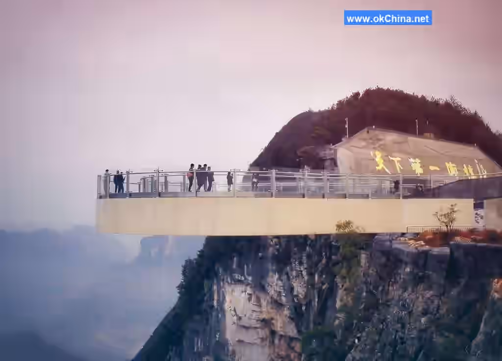
3.2 Cloud Cliff Walk
The Cloud Cliff Walk is built atop a sheer cliff at an altitude of 1010 meters in Longgang. Its cantilevered length is 26.68 meters, over 5 meters longer than the Grand Canyon Skywalk in the USA, ranking first in the world. The walkway deck and guardrails are made of fully transparent ultra-clear glass, allowing for 720-degree viewing. Its design, visual effects, and thrilling experience are globally leading. The World BASE Jumping Competition is held annually on the walkway, where people can enjoy the natural scenery while experiencing the thrilling sensation of aerial drifting.
3.3 Cloud Cliff Rainbow Swing
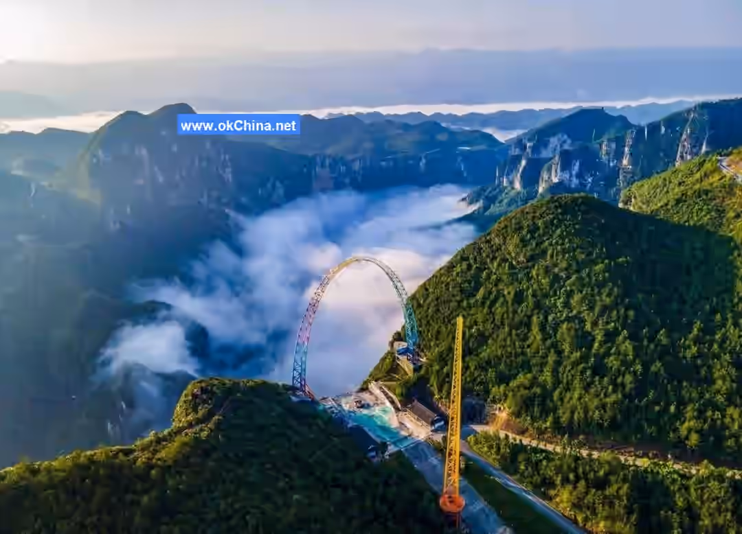
The Cloud Cliff Rainbow Swing is located at Monkey Pass (Houzi Yakou) within the Longgang Scenic Area, installed on the edge of a cliff over 600 meters above Shisun River. The main structure height of the Cloud Cliff Rainbow Swing is 108 meters, with a maximum speed of approximately 120-130 km/h, a lift height of 96 meters, and a maximum swing distance away from the cliff of about 80 meters. It holds the record for the highest, fastest, and largest swing amplitude among similar international products.
3.4 Via Ferrata Experience Project
"Via Ferrata" is an Italian term, a phonetic translation for rock wall exploration or iron-road climbing, referring to climbing routes constructed on mountain rock faces consisting of steel handrails, footholds, safety cables, etc. The Longgang Scenic Area Via Ferrata is located to the left of the landmark Cloud Cliff Walk, with a vertical height of over 700 meters above Shisun River. The climbing route is over 600 meters long, mainly composed of the Rainbow Bridge, steel cable bridges, Changkong Plank Path (Long Sky Cliffside Walkway), Twelve Zodiac Swing Bridges, aerial totem poles, and climbing ladders. The Rainbow Bridge is 62 meters long, named for the different colors and scenery painted on its deck panels. The steel cable bridge is about 41 meters long, consisting of one walking rope and two handrails. The walking rope is very thin, making it exciting and thrilling. The entire project uses chemical anchor bolt anchoring technology to implant steel anchors over 1 meter deep into the rock, with each steel cable bearing a load of approximately 2 tons.
3.5 Cliff Swing
The Cliff Swing is located beside the Cloud Cliff Walk. It is supported by an A-shaped frame and several steel pipes firmly anchored into the cliff to prevent the frame from shifting. The swing height is 12 meters, and it swings out 12 meters at an angle of about 85 degrees. The entire swing from start to stop takes about 5 minutes. To ensure safety, the Longgang Scenic Area Cliff Swing only accepts visitors aged 18-48 with a weight under 85 kilograms. The swing uses a fully automatic device. After a person is seated, an electric mechanism controls the lowering of the safety seat before swinging out, providing a thrilling sensation of weightlessness.
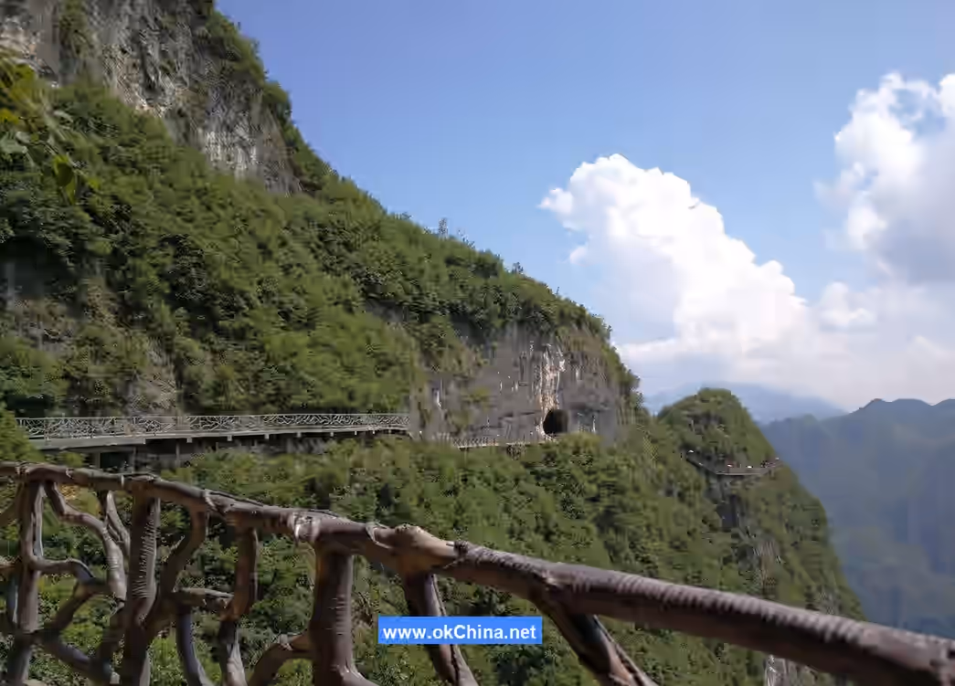
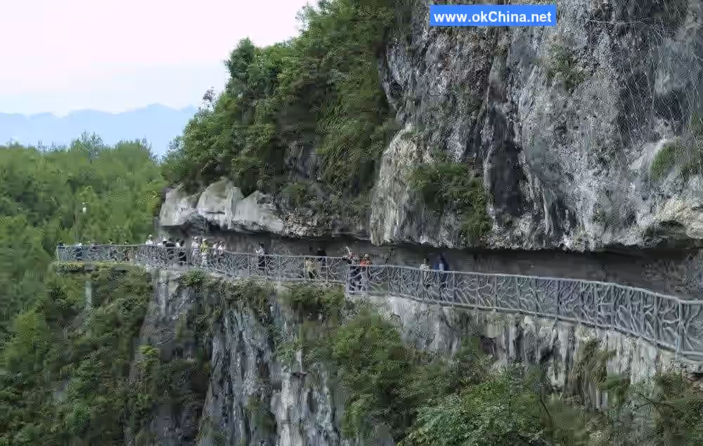
3.6 Cliffside Plank Path
The Cliffside Plank Path is located along the walking trail from Yingyue Cave to Zhakou Stone within the Longgang Scenic Area. Built on cliffs hundreds of meters high, it is an aerial cliffside plank path about 3320 meters long, of which 200 meters is a fully transparent glass walkway. The path is divided into two sections: the Hand-in-Hand Plank Path and the Moon Shadow Plank Path. Walking along it, with thousand-foot peculiar peaks on one side and deep valleys and gorges on the other, feels like traversing perilously between heaven and earth.
3.7 Yingyue Cave (Moon-Reflecting Cave)
Yingyue Cave is located in the sheer cliffs about 100 meters northeast of Longgang, serving as the first-level karst cave of Longgang. It has north and south entrances. The south entrance is 2.9 meters high, the cave is 43 meters long with a diameter of 3.4 meters, and it is the first-level underground river channel of Longgang; the north end is the outlet of the underground river. Every year on the night of the full moon during the Mid-Autumn Festival (the 15th day of the 8th lunar month), the moon rises from the Qiyao Mountain east of Yingyue Cave, and the moonlight passes precisely through the cave. People call this phenomenon "Moonlight Piercing the Cave," which is also the origin of the cave's name, Yingyue Cave.
3.8 Da'an Cave
Da'an Cave is located in the sheer cliffs on the west bank of Shisun River within the Longgang Scenic Area. The cave entrance is about 200 meters above Shisun River and 100 meters below the cliff top. There is a seasonal waterfall on the south side of the entrance, which forms cascading water during the rainy season before converging into Shisun River. Da'an Cave is approximately 3000 meters long in total. The main direction of the primary cave passage is 160 degrees south. The entrance collapsed to form a hall, 50 meters high with a dome shape. Da'an Cave is the largest karst cave, featuring caves within caves, with nine interconnected caverns. Over millions of years, stalactites have transformed into shapes resembling dull-witted crocodiles, turtles stretching their necks and strolling, crabs charging recklessly, spirited lobsters, and winding water snakes, all in various lifelike postures.### 3.9 Dragon Cave The Dragon Cave consists of two halls, front and rear. The front hall is circular, over 40 meters wide, nearly 50 meters high, 120 meters long, covering an area of 4,800 square meters. It is filled with stalactites of various shapes, magnificent and dazzling. Natural landscapes include the "White Jade Dragon Bed," "Dragon Umbrella," "Dragon Pot," "Dragon Chair," "Dragon Stool," "Lotus Platform," and "Heavenly Rooster Announces Dawn." The rear hall is pentagonal, 30 meters high, over 300 meters long, covering an area of 6,000 square meters. The stalactites inside resemble lions, elephants, dragons, and phoenixes—some baring their fangs and brandishing their claws, others spreading their wings as if about to take flight.
3.10 Old Stockade
Located on the southwestern side of Qingshui Township, the Old Stockade sits atop a blade-like ridge composed of thick limestone from the Triassic Jialingjiang Formation. Before the Western Zhou Dynasty, indigenous people inhabited this area, which served as their hereditary territory. The stockade, situated at the highest point of the ridge, was a place for worshiping and offering sacrifices to the goddess. Later, a dragon pillar, or sacrificial pillar, was erected. Due to its long history, it is called the Old Stockade. Remnants include ancient watchtowers, stone gates, the Female Shame Pool, the collapsed sacrificial dragon pillar, and the site of the "Man Fighting Tiger" tower. The mountaintop where the Old Stockade is located is 5–10 meters wide and 50 meters long. Standing atop the peak, one can view the entire Shisun River and hundred-meter-high stone pillars to the west, faintly see the mouth of the Dragon Vat to the north, see the Lianghekou confluence to the south, and observe rural scenery and stone forest clusters to the east.
3.11 Monkey Play Terrace
The Monkey Play Terrace is a favorite spot for wild monkey troops to play. The Longgang Scenic Area attracts a steady stream of tourists year-round, and the wild macaques here have long been accustomed to coexisting with humans. Sometimes they approach visitors to ask for food, adding much joy to the journey. At other times, they leap among tree branches in small groups, appearing carefree and blending seamlessly with the natural landscape, adding a spiritual touch to the scenic area. Additionally, the Monkey Play Terrace offers an excellent vantage point to overlook the Shisun River Grand Canyon. Standing here and looking down, one can take in the breathtaking canyon scenery. After rain, one might even witness the marvelous sights of "Mist in the Long Gorge" and "Golden Monkeys Frolicking in the Forest."
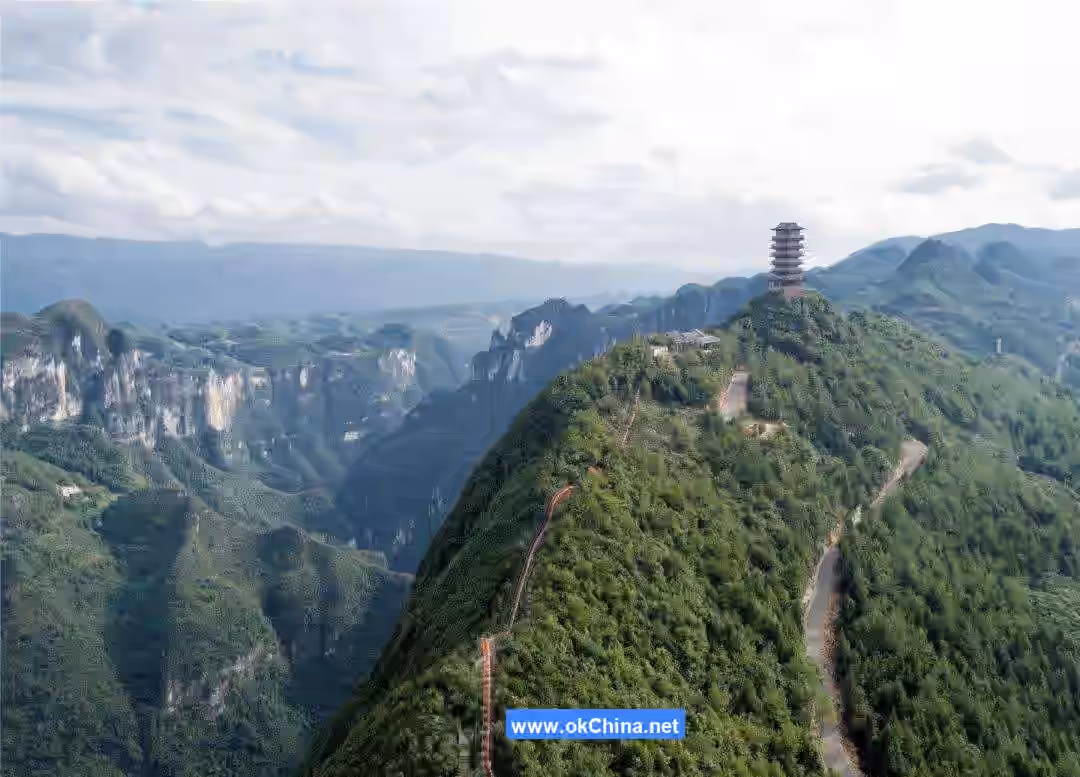
3.12 Qixi Tower
Located at the highest peak of the Longgang Scenic Area at an altitude of 1,185 meters, the Qixi Tower is seven stories tall, totaling 33.44 meters, symbolizing everlasting love and eternal union. The tower covers a construction area of 1,000 square meters. Due to the narrow and steep terrain, construction was challenging. Its high position offers excellent visual effects, making it a rare spot within the Longgang Scenic Area for a 360-degree panoramic view, allowing visitors to experience the feeling of "ascending the summit and dwarfing all surrounding peaks." It is also a special site dedicated to the Salt Water Goddess and integrates love culture, making it a must-visit.
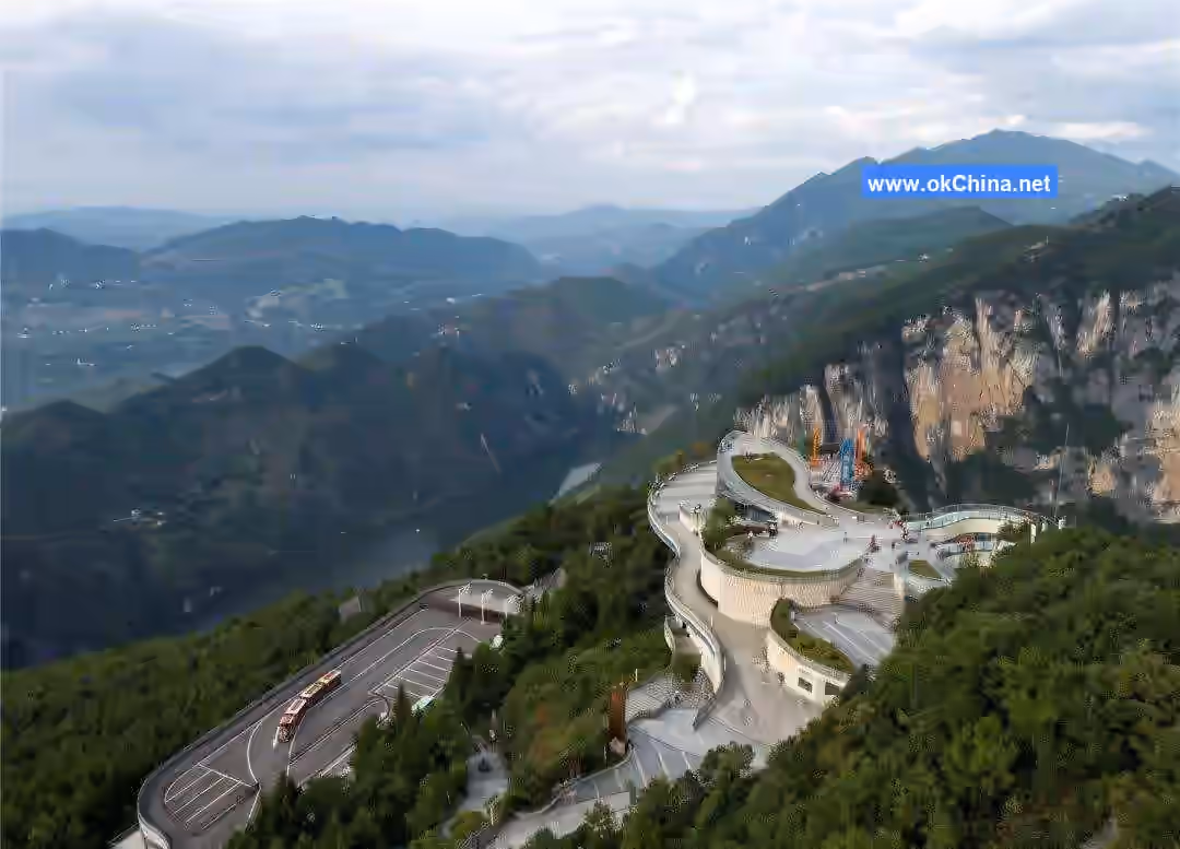
3.13 Shisun River
The Shisun River is the most beautiful section of the Changtan River, stretching from Gaixiaba in the north to Shuanghekou in the south, featuring a karst landscape canyon. It is 12.5 kilometers long, V-shaped, with the narrowest point only 20 meters wide. The entire canyon remains in a pristine state with lush vegetation, serving as a habitat for rare flora and fauna, and boasts up to 12,000 negative oxygen ions per cubic centimeter. The water is perennially clear and emerald green, drinkable directly. Both banks are densely dotted with karst caves and towering stone pillars. Huge karst columns on the steep cliffs, resembling stone bamboo shoots, reach up to 200 meters high, piercing the sky like the "Sea-Calming Needle." The Shisun River area lies in the transitional zone between the Eastern Chongqing Fold Belt and the Hunan-Hubei-Sichuan-Guizhou Uplift Fold Belt. During the Cenozoic era, approximately 67 million years ago, due to crustal uplift and river downcutting, under the combined effects of physical, chemical, and biological external forces, flowing water and dissolution formed multiple layers of intersecting karst caves. Through repeated cycles of erosion/collapse—erosion/collapse, surface features like stone forests, peak clusters, sinkholes, and the three underground karst cave layers formed an integrated system. The relative height difference between ridges and valleys exceeds 1,400 meters, creating a spectacular karst landscape and mysterious canyon scenery.
3.14 Qingshui Lake
Located downstream of the Shisun River beneath the covered bridge, Qingshui Lake has an average altitude of 800 meters. With cool summers and beautiful scenery, it is an excellent summer retreat. Reportedly formed by reservoir impoundment for a power station built by Chongqing Energy Investment Group, it is named for its location in Qingshui and its perennially clear, see-through water. The dam is 160 meters high with a thickness-to-height ratio of only 0.106, making it Asia's thinnest double-curvature arch dam. The impoundment level is 392 meters, with an average depth around 100 meters and a maximum depth over 150 meters. The lake surface covers 6.85 square kilometers with a capacity of 354 million cubic meters. The lake connects the previously inaccessible 15-kilometer stretch of the Shisun River, integrating the Laoya, Yulong, and Shisun gorges.
3.15 Qishan Grassland
Located within the Longgang Scenic Area in the southernmost part of Yunyang County, Qishan Grassland is a mountainous natural scenic area and a Chongqing municipal forest park. It ranges from 1,400 to 1,650 meters in altitude and covers 333.33 hectares. The area features extensive primitive forests with precious tree species such as metasequoia, ginkgo, and iron oak. The average temperature is around 20°C. In summer, the boundless green fields offer a cool retreat; in winter, the snow-covered landscape is perfect for snow viewing; in spring and autumn, blooming mountain flowers create a colorful, idyllic paradise.
3.15.1 Educated Youth Forest
Named after the fir and pine trees planted in clusters by educated youth who settled at the Qiyao Mountain Youth Medicinal Pasture in 1966, this area not only boasts good vegetation, fresh air, and a beautiful environment but also allows us to witness the original aspirations, confidence, spirit, and demeanor of those young people. It evokes reflection on that period of history and life, as well as reverence and gratitude for nature.
3.15.2 Educated Youth Old House
This relatively well-preserved two-story brick-and-wood structure was the female dormitory of the former Qiyao Mountain Youth Medicinal Pasture. Despite the passage of time, people still call it the Educated Youth Old House. Three rooms on the ground floor have been converted into an exhibition hall showcasing the production and daily life of educated youth from various regions during that special era, offering an opportunity to reminisce, witness, and reflect on this history.
3.15.3 Medicinal Pasture Trail
This footpath was originally opened by the educated youth and served as their daily route to and from work at the medicinal pasture. Along this shaded path, one can often spot foraging small animals and rare birds, wild medicinal herbs growing in all seasons, various fungi and small treasures, as well as rare orchid and azalea varieties. Such a natural treasure bestowed by nature is not to be missed.
3.15.4 Twin Dragon Spring
This spring, the only one flowing perennially from the mountaintop in the karst area, is a marvel. The water flows from two separate spring eyes within rock crevices before merging into one. Legend says it is the tears shed by twin dragons trapped under Qiyao Mountain after being subdued by the Twin Dragon Mountain, hence the common name Twin Dragon Spring.
3.15.5 Wanghai Kou (Sea-Viewing Pass)
Wanghai Kou is the best spot within the grassland to view the sea of clouds, commonly called Wanghai Kou. Here, one can observe the formation, surging, and rising of the ever-changing sea of clouds at dawn and dusk. It is a rare site for appreciating climatic landscapes.
3.15.6 Red Heart Forest
This vibrant fir forest is a landmark landscape of Qishan Grassland. Planted by the educated youth half a century ago to express their original aspiration and passion of "a red heart forever loyal to the Party," people call it the Red Heart Forest. Within this forest, one finds joyful birdsong, cool breezes, refreshing shade, a tranquil environment, and fresh air.
3.15.7 Golden Pigs Frolicking in the Granary
This larger stone forest formation, dating back approximately 230 to 270 million years, is a landmark geological relic of Qishan Grassland. Together with surrounding smaller stone forests, sinkholes, shafts, ponors, and fractures, it forms the Qishan Grassland Geological Heritage Protection Cluster. These stone formations resemble groups of wild boars charging and gathering here in lively play, earning the vivid name "Golden Pigs Frolicking in the Granary."
3.15.8 Twin Dragons Probing the Sea
The area now called Qishan was originally named Twin Dragons. Legend has it that the two small hillocks ahead are the heads of twin dragons, as if they are stretching out to gaze at the distant sea. Their bodies, extending along both sides of the road—one high, one low—to the ridge before the Dragon Vat, represent the dragons' torsos. A beautiful legend imbues these two hillocks with magical color, and it is also a great spot for viewing the sea of clouds.
3.15.9 Dragon Turtle Poking Its Head
The small hill ahead resembles a turtle's head. Legend says it was transformed from a dragon turtle that once accompanied the twin dragons. It had just extended its head when it was pinned down by the mountain, leaving it, like the twin dragons, only able to sigh while gazing at the sea. From the Dragon Turtle Hilltop, one can gaze into the distance at the Human Head Stone, watch the clouds roll and unfold, view the nearby green mountains and fields; and also walk hand in hand, whisper sweet nothings, and pledge eternal love.
3.15.10 Sacrificial Mountain
On this mountaintop, there originally stood three stone pillars built from rubble, representing heaven, earth, and humanity. It was a place where the local Tujia people would offer sacrifices to heaven, earth, nature, and their ancestors during festivals, commonly called Sacrificial Mountain. Although the three stone pillars collapsed a few years ago, people still hold sacrificial activities here.
3.15.11 Observation Deck
This is the best spot in the entire grassland for viewing both distant and nearby scenery, hence the name Observation Deck. The Human Head Stone is clearly visible in the distance straight ahead. To the left, the imposing array of wind turbines stands majestic and powerful. To the right, the Twin Dragon mountain ranges run side by side. Below lie the grassland, campsite, Red Heart Forest, Twin Dragon Heads, and Dragon Turtle Hill—truly, scenery is everywhere, all laid out before one's eyes.
3.15.12 Qiyao Mountain Youth Medicinal Pasture
In early 1966, the Yunyang County People's Committee established here the county's first youth medicinal pasture built by educated youth—the Qiyao Mountain Youth Medicinal Pasture.
Comments
Post a Comment