


Li River
1. Introduction
The Li River Scenic Area in Guilin City, also known as the Guilin Li River Scenic Spot, is located in the eastern part of the Guangxi Zhuang Autonomous Region. It is one of the world's largest and most beautiful karst landscape tourist areas. The Li River Scenic Area has a total planned area of 1,159.4 square kilometers, primarily distributed across the Yanshan District and Yangshuo County regions. It consists of five major functional zones: the core scenic area, key scenic areas, general scenic areas, tourist service areas, and control coordination areas. Among these, the core scenic area covers a planned area of 303.2 square kilometers.
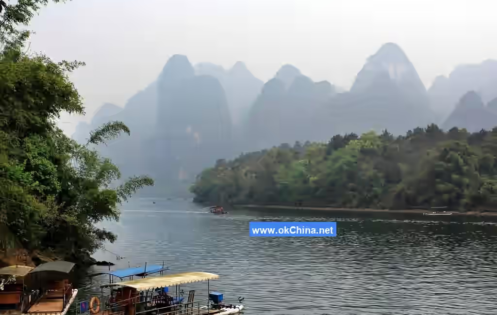
The Guilin Li River Scenic Spot is situated in a subtropical monsoon climate zone, characterized by a mild climate, distinct four seasons with concurrent rainfall and heat, and abundant precipitation. It is the most typical area for karst landform development in northeastern Guangxi. Major natural attractions include Crown Cave, Yellow Cloth Shoal Reflection, and Immortal Pushing the Millstone. It is renowned as the "Hundred-Mile Li River, Hundred-Mile Gallery."
2. Geographical Environment
2.1 Geographical Location
The Guilin Li River Scenic Spot is located at Mao'er Mountain in Xing'an County, northeastern Guangxi Zhuang Autonomous Region, with geographical coordinates of 25°9'35″N, 110°26'18"E.
Guilin is a world-famous scenic tourist city and a renowned historical and cultural city. It lies in the southwestern part of the Nanling Mountain Range, in northeastern Guangxi Zhuang Autonomous Region, between 109°45'–104°40' E and 24°18'–25°41' N. Guilin is situated in the southwestern Nanling Mountain Range, northeastern Guangxi, at the southern end of the Hunan-Guangxi Corridor. It borders Hunan province to the northeast. The Hunan-Guangxi Railway and the Li River run north-south through the area, while the under-construction Guiyang-Guangzhou High-Speed Railway traverses it east-west. National Highways 321, 322, and 323 also pass through. Its coordinates range from 109°36′ to 111°29′ E and 24°15′ to 26°23′ N, with an average elevation of 150 meters. It borders Hunan to the north and northeast, Liuzhou City and Laibin City to the west and southwest, and Wuzhou City and Hezhou City to the south and southeast.
2.2 Topography and Landforms
The topography of the Guilin Li River Scenic Spot is characterized by higher elevations in the north, east, and west, featuring clastic rock low-to-medium mountain landscapes. The north is dominated by Yuecheng Ridge, one of the Five Ridges, with its highest peak, Mao'er Mountain, reaching 2,142 meters. The east features the northeast-southwest trending Haiyang Mountain, whose main peak, Baojie Ridge, is 1,936 meters high. The west consists of the north-south trending Tianping Mountain and Jiaqiao Ridge, with main peaks exceeding 1,000 meters. The central part of the scenic area is the Li River karst valley, stretching over 120 kilometers north-south and 20–60 kilometers east-west. It features landform types such as karst erosion plains, peak cluster depressions, and peak forest plains, forming a relatively complete hydrogeological unit. A series of basins are distributed along the Li River. On the dissolution-erosion plains and lowlands stand numerous stone peaks and a large number of caves. Starting from Qianjing Village south of Daxu, the Li River enters a canyon section through peak cluster depressions. The deeply incised river valley has a relative height of over 400 meters, forming the world-renowned hundred-mile karst landscape gallery.
2.3 Geology
The Guilin landscape is representative of tropical karst landforms, characterized by peak forests and depressions. There are numerous underground caves, primarily dissolutional arch caves. Peak forests can be further classified into isolated peaks, scattered peaks, and peak clusters. The strange peaks and extraordinary caves are typical features of tropical karst.
China's modern karst developed on the basis of a peneplain formed after the Yanshan Movement. In the Guilin area, carbonate rocks (such as limestone, dolomite, gypsum, and rock salt), which serve as the material foundation for karst development, are widely distributed. During the Tertiary period, the tropical climate initiated peak forest development. In the Neogene period, the monsoon climate formed, laying the foundation for the present-day zonality of karst. The hot and humid climate intensified karst development. Especially since the Quaternary period, rapid crustal uplift has led to the swift development of diverse and complex karst landforms.
2.4 Climate and Hydrology
The Guilin Li River Scenic Spot is located in a subtropical monsoon climate zone, featuring a mild climate, distinct four seasons with concurrent rainfall and heat, abundant precipitation, good sunlight, sufficient heat, long summers, short winters, and superior climatic conditions. The annual average temperature is 19.3°C. July is the hottest month with an average temperature of 28°C, while January is the coldest with an average of 7.9°C. Annual rainfall ranges from 1,838 to 1,941.55 mm, exceeding evaporation. The annual average relative humidity is 76%.
3. Important Attractions
3.1 Chuan Hill (Pierced Hill)
Chuan Hill is located on the east bank of the Xiaodong River, southeast of the urban area and southwest of Qixing District, about 3.5 km from the city center. It has an elevation of 224 meters, a relative height of 94 meters, and covers an area of 25.25 hectares. The five winding peaks of Chuan Hill resemble a rooster: the western and eastern peaks form the head and tail, the northern and southern peaks form the wings, and the central peak forms the back. The Moon Cave on the western peak looks like the rooster's eye. Together with Turtle Hill across the river, they vividly resemble two fighting cocks, hence the collective name "Fighting Cock Hills."
3.2 Wangfu Stone (Longing Husband Stone)
Wangfu Stone is located on the west bank of the Li River, in front of Doumi Shoal, about 37 km from Guilin. At the mountaintop, there is an Immortal Stone resembling a figure in ancient attire gazing north. On the mountainside, a stone resembles a woman carrying an infant on her back, gazing into the distance for her husband, hence the name Wangfu Hill, also called Wangfu Stone.
3.3 Longtou Mountain (Dragon Head Mountain)
Longtou Mountain serves as the southern barrier of Dishui Cave (Dripping Water Cave). Its main peak has an elevation of 440 meters, making it the third highest peak in Shaoshan Chong. The Second Revision of the Mao Clan Genealogy of Shaoshan describes Longtou Mountain as "rising abruptly from the ground, holding its head high and standing alone among myriad mountains and valleys... extremely steep. It has fertile land and sweet springs atop... the mountain rushes towards one's face, clouds form at the horse's head." Legend has it that a giant dragon from the Dragon Palace of the North Sea, with its tail submerged in Dongting Lake, raised its head at Shaoshan Chong, forming Longtou Mountain of Dishui Cave.
3.4 Luoshi Hill (Spiral Shell Hill)
Luoshi Hill is on the west bank of the Li River. The rock strata spiral upwards from the base to the summit, making the entire hill resemble a large green spiral shell. Guo Moruo's poem includes the line, "A green spiral shell bears rain, pressing down the long river." At the foot of the hill lies Luoshi Cave (Spiral Shell Cave), with a wide and bright opening. The Tengjiao Nunnery, consisting of the Three Treasures Hall and the Kuixing Pavilion, was built here in the Ming Dynasty and renovated in the Qing Dynasty. In front of the cave is Xianglu Stone (Incense Burner Stone), which bears a striking resemblance. Inside the cave are three spiral shell-shaped stones: one white as snow, one green as jade, and one black as lacquer. The cave contains cliff inscriptions recording its origin and the nearby scenery.
3.5 Xingping
Xingping Town is located in the northeastern part of Yangshuo County, Guilin City, Guangxi Zhuang Autonomous Region, on both banks of the upper Li River, 25 km from the county seat. The Li River flows through Xingping, forming an "S"-shaped bend, making it a concentration of Li River scenery. Marshal Ye Jianying wrote in his poem Boating from Guilin to Yangshuo: "A spring breeze on the Li River, the guest boat glides light, / Strange peaks lining the banks welcome and bid farewell. / A horse leaps atop Huashan, people gaze into mirrors, / Truly, the finest scenery lies in Guangping." Here, mountains and waters are intertwined with dense attractions, combining features of wonder, peril, elegance, beauty, and interest.
3.6 Yellow Cloth Shoal Reflection
South of Painted Hill (Huashan), there is a yellow rock several zhang wide, lying flat on the riverbed like a piece of yellow cloth, hence the name Yellow Cloth and the shoal name Yellow Cloth Shoal. In 2000, the People's Bank of China issued the fifth series of RMB, and the Li River scenery on the back of the 20-yuan note is the Yellow Cloth Shoal Reflection.
3.7 Nine-Horse Painted Hill (Jiuma Huashan)
Nine-Horse Painted Hill is located 4 km northwest of Xingping Town. The hill is over 400 meters high and 200 meters wide, standing by the river with a sheer cliff face, colorful and斑斓, resembling a huge painted screen from afar. Its five connected peaks present a cliff face by the river adorned in blue, green, yellow, and white, with varied shades and mottled patterns, like a divine steed painting, hence the name Nine-Horse Painted Hill, often shortened to Painted Hill.
3.8 Caoping
Caoping is located on the banks of the Li River, 35 km southeast of Guilin City. It borders Chaotian Township of Lingchuan County to the east and Daxu Town to the north, covering an area of 32 square kilometers, three-quarters of which is rocky hills. The 83-kilometer Li River course from Guilin to Yangshuo flows through here for exactly 10 kilometers. The riverway winds with曲折 curves, flanked by林立奇峰, green mountains浮on the water, and river trees reflecting碧绿.
3.9 Yangdi Scenery
The Yangdi tour area stretches from Guanyan Village in Yangdi in the north, connecting to the Xingping tour area, covering an approximately 18-kilometer river section, which is the golden waterway of the Li River. Both banks of Yangdi are lined with bamboo forests, forming a ten-mile green screen swaying among green hills, beautiful waters,飞瀑, and浅滩, creating a serene and tranquil environment for the Li River scenic area.
3.10 Langshi Scenery
Rows of突兀交错礁石 along the riverbank resemble waves in the sea, hence the name "Langshi" (Wave Rocks). The village by the Langshi shore is called "Langshi Village."奇峰耸立 on both banks, with winding waters and a narrow sky.置身于 the mountain-ringed and water-encircled scenery, one can see ahead the water穿through the river gorge, and beside, the峡衬the sail shadows.
3.11 Xialong Scenery
Passing Xialong Village, one encounters the摩天岭 (Skyscraping Ridge) and冲天峰 (Soaring Peak) to the west, forming "Heavenly Pillars Clamping the River." Soaring Peak, together with Yuwet Peak (Fish Tail Peak) and Laoren Zuoji Peak (Old Man Sitting on a Rooster Peak), are collectively called the "Three Peaks of Xialong." The Xialong area is picturesque, with奇峰倒影 in front and层峦叠嶂 behind. Former U.S. President Nixon, while visiting here, compared a peak on the right bank to a pyramid.
3.12 Half-Side Ferry
On the west bank of the Li River, about 43 km from Guilin City, stands the 400-meter-high Dutou Mountain (Ferry Head Mountain) by the river. Its sheer cliff intercepts the south-flowing river, stirring up汹涌浪花. There are two villages on either side of the mountain: Guanyan Village and Taoyuan Village, separated by the high mountain, relying on ferry boats for交通. This ferry point differs from the usual crossing from one bank to the other; it is a ferry on one side only, hence called Half-Side Ferry.
3.13 Crown Cave (Guanyan)
Crown Cave is located in Caoping Township on the east bank of the Li River, 29 km south of Guilin City. It is named for its hill shape resembling an emperor's purple gold crown. Crown Cave is a giant underground river溶洞, 12 km long, originating from Haiyang Mountain east of Guilin. It officially opened to the public in 1995. Here, peaks compete in beauty,碧水 convey affection, and the cave and stones are extraordinary. When night falls, wonderful ethnic song and dance performances are held, with passionate folk songs echoing through the峡谷.### 3.14 Huangniu Gorge Located on the west bank of the Li River, south of Mopan Mountain, and facing Bijian across the river, Huangniu Gorge is approximately 30 kilometers from Guilin. The gorge is renowned for its numerous peculiar rocks, resembling green lotuses, lions, tigers, bats, and herds of yellow cattle, from which it derives its name. At this point, the clear waters of the Li River make a sharp 90-degree turn, splitting into two streams that surge against three islets before rolling southward.
3.15 Daxu Ancient Town
Daxu Ancient Town is situated 18 kilometers southeast of the renowned tourist city Guilin and 30 kilometers from Lingchuan County. Nestled in the middle reaches of the Li River, it stretches along the northern bank from west to east, exuding a rich ancient charm. Covering an area of 193.78 square kilometers, Daxu served as a vital land and water transport hub in northern Guangxi, connecting to Hunan and Jiangxi in the north and Wuzhou and Guangzhou in the south. It was a distribution center for agricultural products, sideline products, and imported goods in the eastern suburbs of Guilin.
3.16 Guilin Ta Mountain
Ta Mountain stands on the east bank of the Li River and the west bank of the Xiaodong River, facing Chuanshan across the water. It has an elevation of 194 meters, a relative height of 44 meters, and covers an area of 2.75 hectares. Approximately one million years ago, Ta Mountain and Chuanshan were part of the same mountain mass. Subsequent crustal uplift and a drop in the groundwater level caused the mass to be cut and separated into independent solitary peaks.
3.17 Stone Man Pushing a Mill
Located on the left bank of the Li River near Taoyuan Village, this site is named for the scene on the opposite bank: Renzai Mountain resembles a surfacing seal, with a large, flat, round rock on its summit looking like a millstone. Next to it stands a tilted stone over 3 meters high, vividly resembling a person pushing the mill, hence the name "Stone Man Pushing a Mill." Legend tells of an immortal who pushed a "celestial mill" to grind stones into rice, feeding the people below. A greedy landlord, upon hearing this, tried to monopolize the rice-producing cave by enlarging its opening, only to be swept into the river's heart by a strange wind from the cave and drowned.
3.18 Langshi Scenic Spot
Located about 2 li downstream from Yangdi Market, this spot is named for the waves stirred by shoal rocks in the river in front of the village. The scenery here is uniquely charming: the water winds through gorges, boats sail close to mountains, and deep pools connect with shoals. Both banks are shaded by dense foliage, with continuous bamboo groves and mountain ridges reflected in the river. During the rainy season, the misty river surface and the silhouetted mountains create a particularly graceful scene. Behind the village, over a dozen peaks of varying sizes cluster closely together, forming groups of peak forests that resemble bamboo shoots vying for sunlight.
4. Cultural Resources
4.1 Naming
The Ling Canal is divided into the South Canal and the North Canal. The water originating from Mao'er Mountain flows through the Ling Canal, where it is split by the canal's Tianping Dam in a ratio of three to seven. Seventy percent of the water enters the main channel of the Xiang River via the North Canal, while thirty percent flows into the Li River via the South Canal. Because the waters separate at the Tianping Dam of the Ling Canal, the term "相离" (xiāng lí, meaning to separate) is homophonic with "湘漓" (Xiāng Lí). The northward-flowing water was thus named "Xiang," becoming the Xiang River, and the southward-flowing water was named "Li," becoming the Li River.
In the Guilin Li River Scenic Area, Emperor Qin Shi Huang, to unify Lingnan, ordered the excavation of the Ling Canal in present-day Xing'an County, diverting water from the Haiyang Mountain to flow north and south. People named the rivers based on the idea of a single source splitting and flowing apart. The northward water was called Xiang Water, and the southward water Li Water. "离" (lí) was an interchangeable character in ancient times. Later, people added the three-dot water radical (氵) to "离," specializing it as a water name, which became today's "漓江" (Lí River). Song Dynasty scholar Liu Kai wrote in "On the Xiang and Li Rivers": "The Xiang and Li Rivers originated from one water... later separating into north and south streams. The north is the Xiang River, the south is the Li River." This is the earliest evidence of "Li Water" evolving into "Li River." The Li River is also called Gui River and Gui Water. It earned the name Gui River from the record in the Old Book of Tang: Geography: "The river's source has many osmanthus trees, with no miscellaneous woods," and the name Gui Water because it originates from the Gui direction (north-northeast). Historically, it was also called the East River due to its location east of Guilin's urban area. The names Gui River and Gui Water have long fallen out of use, while "Li River" has become the most famous and common name.
4.2 History and Culture
In 221 BC, Emperor Qin Shi Huang, after unifying the six states, sent General Meng Tian north to build the Great Wall against the Xiongnu and dispatched Commandant Tu Sui south with an army of 500,000 to conquer the Baiyue. In 218 BC, the campaign "Qin Garrisoning the Five Ridges" officially began. Commander Tu Sui fought fiercely for three years without success and was eventually killed by the Yue people. In 214 BC, the First Emperor decided to "connect the Xiang and Li, linking the Han and Zhuang," and ordered the construction of the Ling Canal. Supplies and troops could then travel directly from the Xiang River into the Li River, allowing the Qin army to conquer Lingnan swiftly. From then on, the Li River and Guilin formally entered the central plains' view. Simultaneously, the Ling Canal became one of the Qin Dynasty's three major hydraulic engineering projects (the other two being the Dujiangyan in Sichuan and the Zhengguo Canal in Shaanxi), earning the reputation "In the north there is the Great Wall, in the south there is the Ling Canal."
Historical records indicate that the earliest cultured official in Guilin was likely Yan Yanzhi, a great literary figure of the Southern Dynasties. He was as famous as the contemporary poet Xie Lingyun, together known as "Yan and Xie of Jiangzuo."
By the Tang Dynasty, Guilin finally welcomed the great literary figure Liu Zongyuan, who was exiled to a southern post. Facing the vast, misty beauty of the Li River, he wrote the famous "Record of the Zizhou Pavilion in Guizhou." The most famous lines are: "The elephant's trunk faces Zizhou, the river flows on both sides; wealth does not last three generations, an honest official is hard to keep." The great poet Li Bo, a contemporary of Liu Zongyuan, also contributed significantly to Guilin's cultural development. He served as Prefect of Guizhou and concurrently as Military Commissioner of the Gui Region in the first year of the Baoli era (825 AD). At that time, Duxiu Peak and Yu Mountain were already tourist attractions, while Yin Mountain and Nanxi Mountain remained largely unknown. It can be said that the discovery and development of Nanxi Mountain owe much to Li Bo. He personally wrote "Nanxi Poem with Preface" to record it: "The Gui River passes the Li River, converges with the Yang River on the right, and after a little over a li, reaches the mouth of Nanxi... To the right connects secluded villas, gardens, fields, chickens, and dogs, making one doubt it is not of this world... As the stream is south of the prefecture, it is named Nanxi." The name Nanxi Mountain was also given by Li Bo. He devoted great effort to developing Nanxi Mountain, cutting paths along the rocks, building pavilions, and planting pines and bamboos for tourists. So much so that years later, "Fresh Sunshine at Nanxi" became one of the "Eight Scenes of Guilin." Today, Yin Mountain and Nanxi Mountain still bear inscriptions of three poems Li Bo wrote in Guilin.
During the Song Dynasty, Guilin's history and culture entered a golden age. In the seventh year of the Xining era of Emperor Shenzong of the Northern Song, the famous calligrapher Mi Fu, only 23 years old, took up the post of County Lieutenant in Lingui County, Guangxi. In May of that year, he visited the Return Pearl Cave on Fubo Mountain in Guilin with County Magistrate Pan Jingchun. Inspired, Mi Fu inscribed on the rock wall opposite the Trial Sword Stone: "Pan Jingchun and Mi Fu visited together on the last day of May, Xining 7th year." Mi Fu's self-portrait remains on the cave wall to this day, a masterpiece among Guilin's stone carvings. Wang Zhenggong, then the Judicial Commissioner of Guangxi, improvised a poem at a farewell banquet for Guilin scholars heading to the capital for the imperial examinations, writing the famous lines: "Guilin's landscape is the finest under heaven, its jade-green peaks and silk-blue waters offer profound meaning." From then on, "Guilin's landscape is the finest under heaven" became renowned throughout China.
By the late Ming and early Qing dynasties, the extraordinary painting talent, the Bitter Gourd Monk Shi Tao, was born in Guilin. Shi Tao was the tenth-generation descendant of Zhu Zanji, the Prince of Jingjiang in Guilin, and the eldest son of Zhu Hengjia, originally named Zhu Ruoji. In the second year of the Shunzhi era of the Qing Dynasty (1645), Guilin city fell, and in an instant, the once prominent royal descendants became impoverished commoners. Faced with the Li River's stunning beauty, the 14-year-old Shi Tao was deeply moved and painted numerous ink wash paintings of the Li River. This extraordinary painter continues to influence the art world in China and globally.
By the Qing Dynasty, Guilin's history and culture, having accumulated over two thousand years, were brilliant and splendid, reaching a peak of prosperity. Chen Hongmou from Hengshan Village, Sitang Township, Lingui County, held the highest official rank (Grand Secretary of the Eastern Pavilion), was granted the title of Crown Prince's Grand Tutor, and reached the pinnacle of officialdom.
With prefectural schools in the Tang Dynasty and imperial examination halls in the Qing, since the imperial examination system began in the Sui and Tang dynasties, Guilin has produced 7 top scholars (zhuangyuan), 2 second-place scholars (bangyan), and 291 advanced scholars (jinshi), earning its reputation as a "Hometown of Top Scholars" famous far and wide.
4.3 Related Culture
4.3.1 Li River Nuo Art
Among the folk communities along the Li River, traditional cultural activities are also very vibrant, with Nuo art and folk songs being the most representative. Locally known as "jumping gods," it is an ancient folk art in the Li River basin. Originating from ancient Nuo rituals, it spread from the central plains to northern Guangxi, influenced by Chu culture, and combined with local customs. By the Northern Song Dynasty, it had developed into a popular folk art form in Guilin.
4.3.2 Calligraphy and Seal Carving
Inscriptions, plaques, couplets, and stone tablets in the Li River scenic area are artistic expressions of ancient calligraphy along the river's banks. In the calligraphic works of the Li River basin, due to the high cultivation and aesthetic taste of the calligraphers, most possess distinct and unique styles. When creating, they unconsciously integrate their understanding and feelings about life and the environment into their works, imbuing them with unique charm and achieving a state where form and spirit are united. These works harmonize with their surroundings, offering viewers aesthetic pleasure and rich historical and cultural knowledge.
4.3.3 Caidiao Opera
Commonly known as "tunes," "colorful lanterns," or "nahehai" (it was officially named Caidiao in 1955 when participating in the Beijing Mass Music and Dance Observation Performance), Caidiao belongs to the lantern opera system. It originated from the "paired tunes" evolved from rural songs, dances, and storytelling in the Li River basin. Later, it spread to other parts of Guangxi, becoming a very popular local opera, still active in cities, counties, and vast rural areas. Caidiao emerged during the Song and Yuan dynasties and matured in the Ming and Qing periods. Its repertoire, lyrics, performance, and costumes all have their own unique style.
4.3.4 Painting and Sculpture
The origins of fine arts in the Li River basin can be traced back to the Neolithic Age, 7,000 to 10,000 years ago. Simple decorative patterns were found on pottery such as jars, urns, cauldrons, tripods, and bowls excavated from the Zengpiyan site. From the Tang to the Qing Dynasty, painting and sculpture in the basin reached a high level, mainly reflected in the stone carvings and cliff statues distributed across famous mountains in the urban area. The extant Tang Dynasty cliff carving of Laozi on Yin Mountain is vivid in form with vigorous lines. The over 140 niches and more than 500 Tang Dynasty cliff statues on Fubo Mountain, West Mountain, and Liuma Mountain are remarkable for their quantity and artistic level, rare even nationally.
Comments
Post a Comment