


Koktokay Scenic Area in Altay Region
I. Introduction
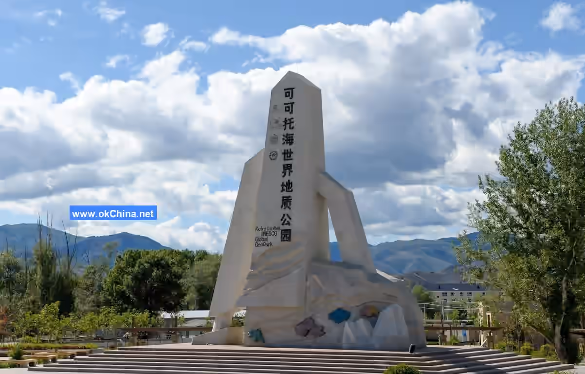
Koktokay Scenic Area, also known as Xinjiang Koktokay National Geopark, is located in Fuyun County, Altay Region, in northern Xinjiang. It covers an area of 788 square kilometers, approximately 485 kilometers from Urumqi and 53 kilometers from Fuyun County town.
The scenic area consists of four main parts: the Irtysh Grand Canyon, Koktokay Lake (Koktokay Su), Yileimu Lake, and the Karaxanger Earthquake Fault Zone. It features beautiful canyon rivers, mountainous forests, mineral resources, extremely cold lakes, and unique earthquake fault zones as its natural landscapes. Integrating geological culture, regional characteristics, and ethnic customs, it is a large-scale tourist destination known for sightseeing, leisure vacations, special interest tourism (such as hiking and photography), and scientific research.
II. Historical Development
- 1930: The Koktokay mining area was discovered, and local ethnic minorities began mining the No. 3 Vein.
- 1935: A Soviet geological team arrived in Koktokay for exploration and trial mining.
- 1950: The "Altay Mining Administration of the Sino-Soviet Nonferrous and Rare Metals Joint Stock Company" was established.
- 1955: The mining area was transferred to Chinese independent management and renamed the "Koktokay Mining Administration of the Xinjiang Nonferrous Metals Company under the General Administration of Nonferrous Metals, Ministry of Metallurgical Industry."
- 1958: It was renamed the Koktokay Mining Bureau.
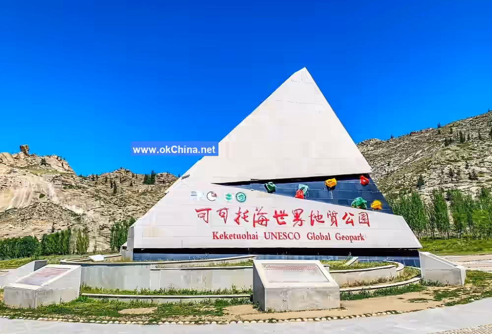
- 2005: Koktokay Scenic Area was approved as a National Geopark.
- 2008: Koktokay National Geopark officially opened to the public.
- 2009: It was rated as a 4A-level scenic area.
- 2010: It received the honorary title of "International Ecotourism Scenic Area."
- 2012: It was upgraded to a National 5A-level Tourist Attraction.
- 2023: Koktokay Ski Tourism Resort was designated as one of the second batch of National Ski Tourism Resorts.
III. Geographical Location
Location and Boundaries
Koktokay Scenic Area in Altay Region is situated in Fuyun County, Altay Region, Xinjiang Uygur Autonomous Region. It spans an area of 788 square kilometers, crossing Fuyun County and Qinghe County, and is about 33 kilometers from Fuyun County town. Its northern boundary starts from the Kaladuergen River, extends south to Karaxanger, west to Kalagezeng, and east to Kalazhuole and Tayit.
Topography and Landforms
Koktokay is located on the mid-mountain slopes of the central Altay Mountains, at an altitude of 1,200–1,500 meters. Due to unique geological structures, weathering, and fluvial erosion, many granite canyons have formed here. The area contains typical granite pegmatite-type rare metal deposits, mining relics, and unique Altay-style granite landforms.
Climate
Koktokay experiences a typical continental climate with significant diurnal temperature variations. Summer average temperatures range from 20–35°C. Winter temperatures range from -26.4 to -32.7°C, with the lowest recorded temperature reaching -51.5°C. Snowfall typically begins in October and gradually melts by April or May of the following year. Snow cover thickness ranges from 0.5 to 1 meter, and can be even thicker in some years.
Natural Resources
Mineral Resources
Koktokay is rich in mineral resources, with the most representative being the No. 3 Vein. It contains 84 rare minerals, including lithium, beryllium, tantalum, niobium, and cesium, earning it the title "Natural Geological Museum." Its beryllium reserves rank first in China, while cesium, lithium, and tantalum reserves rank fifth, sixth, and ninth nationally, respectively.
Biodiversity
- Flora: Koktokay National Geopark is located in the middle section of the Altay Mountains, featuring diverse vegetation types. Recorded plants include 19 species of ferns from 7 families and 8 genera; 9 species of gymnosperms from 3 families and 4 genera; among angiosperms, dicots comprise 782 species from 58 families and 312 genera, accounting for 80.84% of the total; monocots comprise 157 species from 13 families and 61 genera, accounting for 16.25% of the total.
- Fauna: Koktokay National Geopark is rich in wildlife resources, including 54 species of mammals, 251 species of birds, 11 species of amphibians and reptiles, and 8 species of fish. National first-class protected animals include sable, wolverine, snow leopard, Siberian ibex, and beaver. National second-class protected animals include 10 species such as dhole, brown bear, and stone marten.
IV. Famous Attractions
Koktokay Lake (Koktokay Su)
Koktokay Lake is located northeast of the Turghun Basin in Fuyun County. It covers an area of 2 square kilometers with an average depth of 2 meters. Formed by meltwater from surrounding mountain snow, it is a naturally occurring marsh wetland with clear blue water rich in aquatic plants and animals. During summer and autumn, large numbers of red geese, swans, gray cranes, gulls, and wild ducks gather here to breed and thrive.
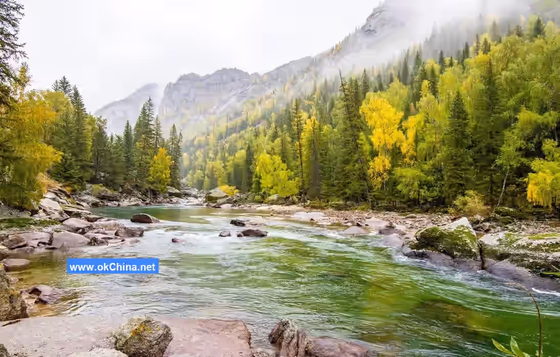
Irtysh Grand Canyon
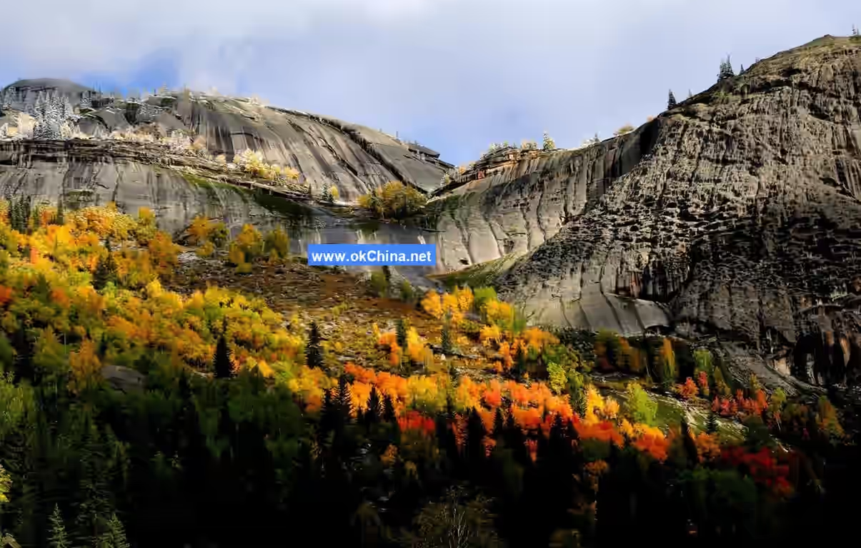
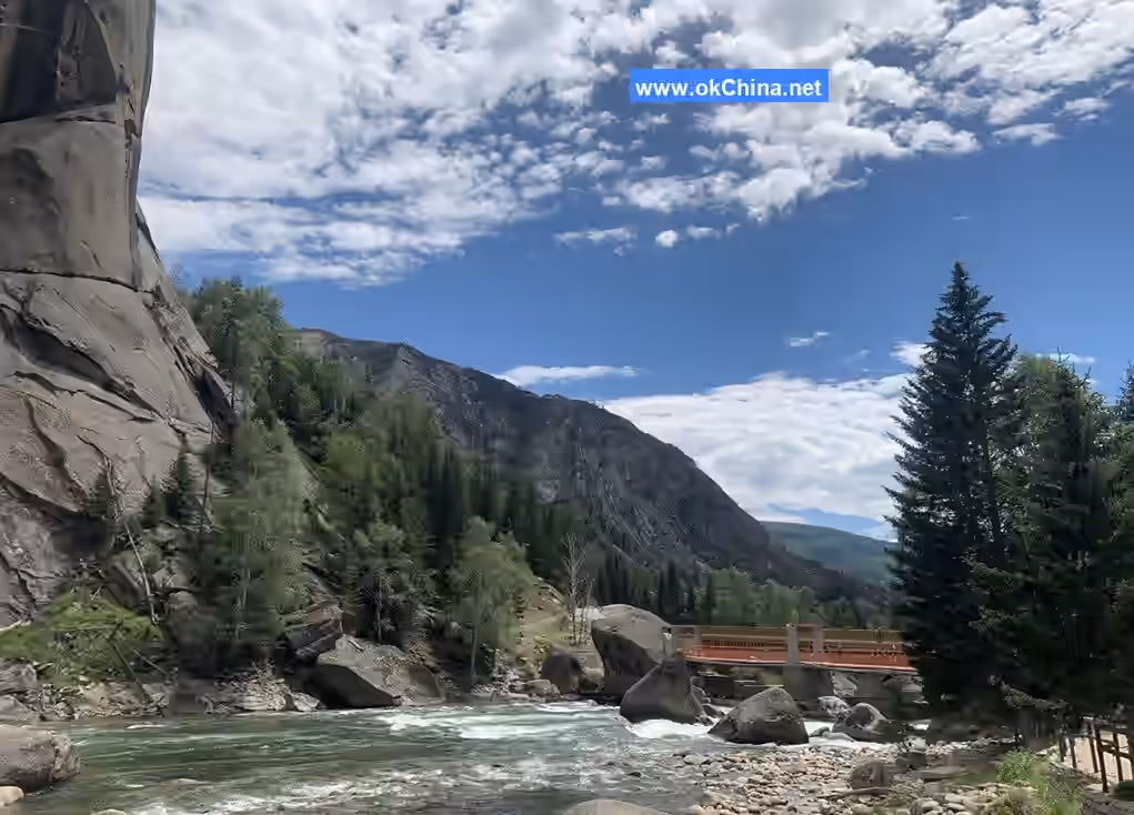
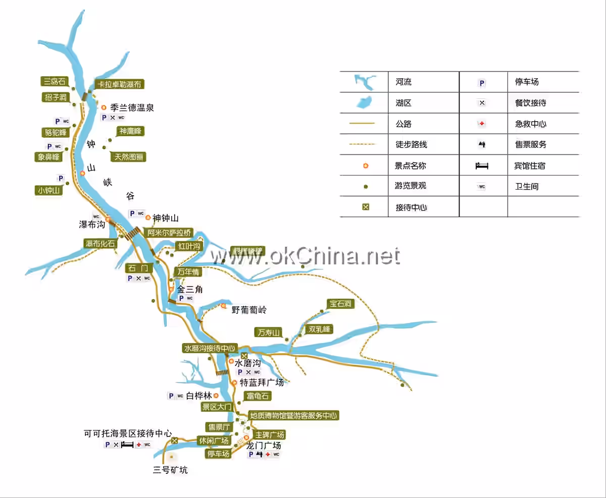
The Irtysh Grand Canyon is located in Fuyun County, Altay Region, Xinjiang, and is a major attraction within Koktokay National Geopark. Along the Irtysh River, rows of granite peaks stand facing each other. These peaks are rounded and diverse in shape, each telling a beautiful story, collectively known as the "108 Peaks." Uniquely, the surfaces of these granite peaks often feature dense honeycomb-like pits and vertical grooves resembling frozen giant waterfalls, akin to fossilized waterfalls.
Yileimu Lake
Yileimu Lake is situated at the confluence of the Irtysh River and the Kayierte River. It covers an area of 212.5 square kilometers at an altitude of 1,120 meters, with a storage capacity of 113 million cubic meters and a maximum depth of about 100 meters. Viewed from above, it resembles a giant figure "8." It is the largest barrier lake on the Fuyun Earthquake Fault Zone. Majestic peaks stand on its east and west sides, while lush trees, vast farmlands, and villages adorn its north and south shores. The central part of the lake is largely carved away by two large mountains on its east and west sides.
Karaxanger Earthquake Fault Zone
The Karaxanger Earthquake Fault Zone is located about 30 kilometers southeast of Fuyun County town. It is a remnant of the 1931 Fuyun magnitude 8.0 earthquake and is one of the world's rare earthquake fault zones. The earthquake had global impact, with noticeable tremors felt across a diameter of 2,500 kilometers. It left behind a spectacular collapse zone at the Karaxanger center, measuring 1,500 meters long and 350 meters wide. Hard rock layers were split open, forming a trench 6 meters wide and over 10 meters deep. A 20-kilometer-long mountain slope slid down by 10 meters, accompanied by seismic relic landscapes such as ridges, bead-like fault depressions, bulges, and tension cracks. These relics remain well-preserved and hold value for geological research, scientific investigation, and ecotourism.
Dragon Gate Square
Dragon Gate Square is located at the entrance of the Irtysh Grand Canyon scenic area. The mountains encircle the square, connecting with the Irtysh River at both ends. It consists of four parts: the Tourist Service Center and Geological Museum, the Main Monument Square, the Ecological Parking Lot, and the Leisure Square.
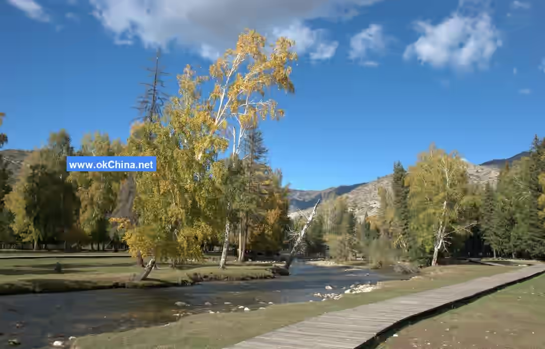
Birch Forest
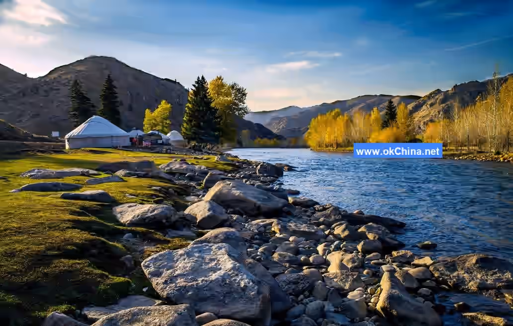
The Birch Forest grows on the convex bank of the Irtysh River, covering an area of 1.5 square kilometers. It comprises three birch islands of varying sizes, primarily consisting of birch trees, with Siberian poplars as secondary species. The forest is a cold-temperate mountainous broadleaf secondary forest.
Hundred Flowers Meadow
The Hundred Flowers Meadow is located in the Irtysh Grand Canyon within Koktokay Scenic Area, Fuyun County, Xinjiang. The clear Irtysh River flows along its western side. The meadow is adorned with flowers such as baby's breath, wild rapeseed, azaleas, wild chrysanthemums, and prickly roses.
Canyon Granite Scenic Area
The Canyon Granite Scenic Area is located on both banks of the Irtysh River within Koktokay Scenic Area, Fuyun County, Xinjiang. It primarily features numerous pictographic rocks along the 7-kilometer road from Shenzhong Mountain to Jilande Hot Spring, collectively known as the "Canyon Granite Scenic Area." Attractions include Fossilized Waterfalls, two massive gneissic granite formations, the Immortal's Chair, and the Inverted Boot Peak. There are also many rock formations resembling small animals, such as Giant Python Emerging from the Mountain, Elephant Trunk Peak, Camel Peak, Divine Eagle Peak, Centaur, and Noah's Ark.
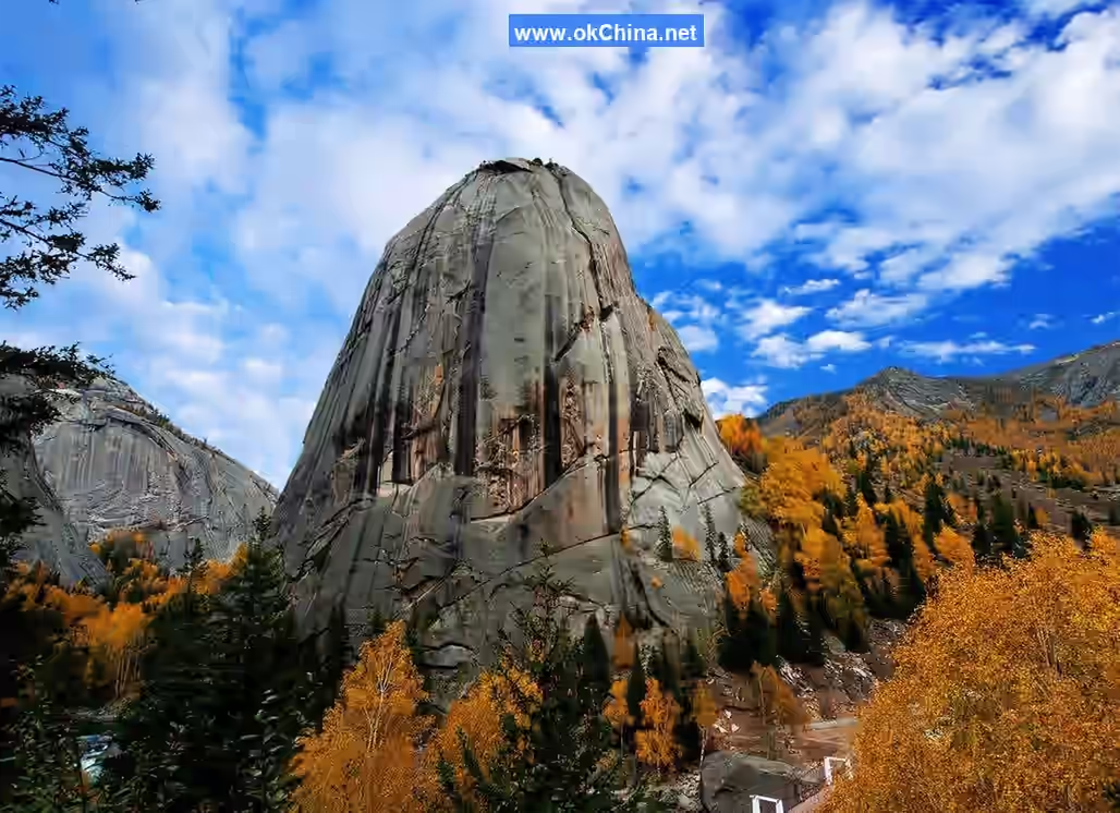
Shenzhong Mountain (Divine Bell Mountain)
Shenzhong Mountain, also known as Amir Sala Peak, is a bell-shaped conical granite peak rising abruptly from the flat land on the south bank of the Irtysh River. With an altitude of 1,608 meters and a relative height difference of 365 meters, it is the most prominent mountain scenery in the Altay Mountains. Birch trees, pines, and Siberian spruces grow in the crevices of its rock walls. Due to the development of concentric layered joints parallel to the slope and the effects of freeze-thaw weathering, continuous exfoliation and collapse along these joints have given the mountain surface a smooth, rounded, yet steep appearance, forming its distinctive bell-shaped landform.
No. 3 Vein
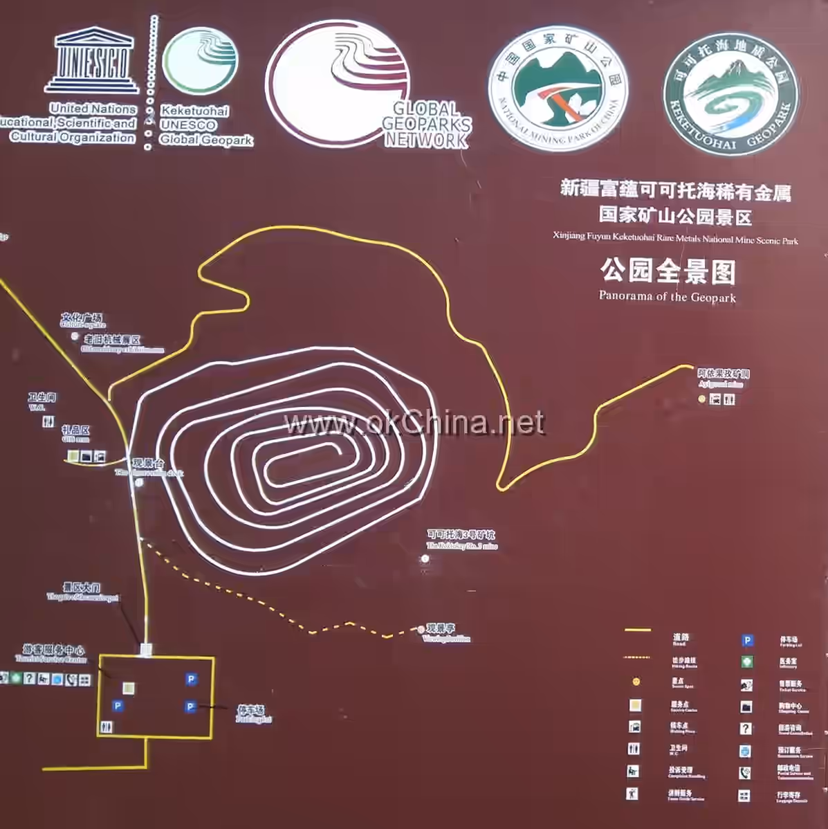
The Koktokay No. 3 Vein is one of the world's largest and most typical granite veins containing rare metals. It is regarded as a "holy site" for Chinese and foreign scientists studying granite pegmatites and rare metal deposits and was once part of the golden inspection route for the Beijing International Geological Congress. After 50 years of mining, the No. 3 Vein, originally a towering gabbro mountain hundreds of meters above ground, has been excavated into a pit 143 meters deep, 250 meters long, and 240 meters wide, with spiral mining roads resembling the grand "Colosseum" of ancient Rome. The pit contains 86 coexisting minerals, including 7 not found on the periodic table, primarily various rare metal elements such as lithium, beryllium, tantalum, and niobium. This vein is unique in China and rare worldwide for its abundant reserves, large scale, variety of minerals, high grade, and distinct zoning. Renowned as the "Geological and Mineral Museum," it is considered a "holy site" by geologists worldwide.
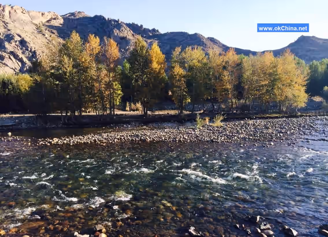
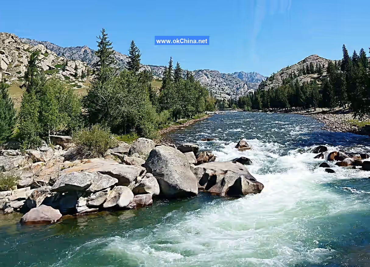
Irtysh RiverThe Irtysh River is the only river in China that flows into the Arctic Ocean. It originates from the southwestern slopes of the Altai Mountains on the northern side of the park and is primarily fed by snowmelt, ice melt, and precipitation. Its two mountain sources, the Kayirt River and the Kuyirt River, converge to form the Irtysh River. Flowing from southeast to northwest out of China, it gathers tributaries from the northern bank, including the Kelan River, Burqin River, Haba River, and Beileizeke River, before entering Kazakhstan and flowing into Lake Zaysan. It then continues northward through Russia's Ob River into the Arctic Ocean. With a total length of 4,248 kilometers, 546 kilometers of which lie within China, the river has a drainage area of 57,000 square kilometers and an annual runoff of 11.1 billion cubic meters, making it the second-largest river in Xinjiang by water volume, after the Ili River. It is the second-largest river in Xinjiang. The river is rich in fish, and near the border, it widens to about a kilometer, allowing for steamship navigation. Numerous tributaries join the main stream from the right bank, forming a typical comb-shaped drainage system. The scenery along the Irtysh River is magnificent, and it is poetically referred to as the "Silver Water" to complement the "Golden Mountain."
V. Cultural Resources
Geological Culture
Keketuohai is China's first national geopark centered on typical mineral deposits and mining sites, earning it the reputation of a "Geological and Mineral Museum." The No. 3 Vein is a rare large-scale rare metal granite pegmatite deposit in the world, rich in 86 types of minerals such as beryllium, lithium, tantalum-niobium, rubidium, and cesium. It serves as a classic mining area for both domestic and international scientists studying granite pegmatites and rare metal deposits.
Red Culture
Keketuohai Rare Metal National Mine Park is a mining-themed tourist attraction centered on red culture. It commemorates the glorious history of the first generation of pioneers in New China, who worked hard here to share the country's burdens, repay Soviet debts, and contribute to the "Two Bombs, One Satellite" program. It is an important patriotic education base, allowing visitors to deeply appreciate the selfless dedication and great patriotic spirit of the older generation of builders.
Historical Architectural Culture
Keketuohai Town preserves over 40 Russian-style historical buildings, renowned for their exquisite craftsmanship and unique style. These buildings bear witness to the historical changes in Keketuohai and reflect the cultural exchange and integration between China and Russia at the time. They hold significant historical, cultural, and artistic value. Walking among them, visitors feel as if they have traveled back to that special historical period.
Gemstone Culture
Keketuohai is rich in various gemstones such as aquamarine, tourmaline, garnet, rose quartz, jade, and crystal. The local gemstone culture has a long history. These colorful and translucent gemstones are not only gifts of nature but also important symbols of local culture. They attract numerous visitors to explore the mysteries of gemstones and experience the unique charm of gemstone culture.
Folk Activities
-
Keketuohai Harvest Festival: Held around September 22 each year, the Harvest Festival is a major local event. During the festival, the birch forests come alive with a series of vibrant ethnic performances, such as the heartfelt "Shepherd of Keketuohai," the graceful "Maiden of the Western Regions," the soulful "A Glass of Fine Wine," the passionate "Uzbek Dance: Eternal Love," and the rhythmic "Black Steed." These performances showcase the charm of Western Regions culture and the boldness and resilience of the grassland people, expressing joy for the harvest and love for life. Additionally, the Harvest Festival includes a fish release activity in the Irtysh River, where visitors can participate and contribute to protecting the river's ecosystem while experiencing the local reverence for nature. The event also features a non-legacy cultural market showcasing Fuyun County's specialty agricultural and pastoral products and cultural creative items, such as blackcurrant jam, cheese, Kazakh embroidery, safflower tea, and gemstone crafts. Visitors can sample local delicacies, purchase souvenirs, and gain a deeper understanding of Keketuohai's unique culture.
-
Sheep Herding Competition: As a traditional activity of the Kazakh ethnic group with a long history, the sheep herding competition is rich in ethnic characteristics and offers strong competitiveness and观赏性. Originating from the daily lives of herders, participants skillfully use body language and vocal cues to guide and herd sheep in an orderly manner. The competition atmosphere is lively, allowing visitors not only to appreciate the herders'娴熟的 skills but also to participate and experience the乐趣 of a "shepherd's" life while感受 the charm of Kazakh traditional culture.
-
Kazakh Traditional Wedding: If visitors have the opportunity to attend a traditional Kazakh wedding, it will be an unforgettable cultural experience. The wedding typically lasts several days and includes a series of unique rituals and activities. From the groom's "water-treading ceremony" when fetching the bride to traditional竞技 activities like "goat snatching" and "girl chasing" at the bride's home, and then to歌舞 performances and sharing of traditional美食 at the wedding, every环节 is filled with rich ethnic customs. These showcase the Kazakh people's marriage traditions, family values, and social culture, allowing visitors to gain an in-depth understanding of their traditional culture and way of life.
Comments
Post a Comment