Jingpo Lake Scenic Area

Ticket Price

Ticket Information

  • Adult Ticket: ¥100.

Opening Hours

Opening Hours

  • Open 24 hours a day.
  • Additional Notes:
    • Year-round: 08:30-17:00 (last entry at 16:00);
    • Boat service hours: 7:00-16:40 (June 22 - October 15)
    • Please refer to the actual opening hours disclosed by the scenic area on the day of your visit.

Recommended Duration

Suggested Duration of Visit

It is recommended to spend 1-2 days.

Best Time to Visit

Best Time to Visit

Optimal Season
Recommended from June to September, during which the average temperature is 17.3°C. This period also sees the highest water levels of the year, making the waterfalls particularly spectacular. Additionally, with minimal wind, the lake surface remains as smooth as a mirror.

Official Phone

Scenic Area Contact

0453-8679999; Mobile: 13351235190.

Transportation

Transportation Guide

Getting There

① In front of Mudanjiang Railway Station, there are daily buses directly to the main scenic area. They usually depart in the morning and return in the afternoon. The one-way fare is approximately 25 yuan, and the journey takes about 2 hours.

② You can take a bus from Mudanjiang Long-Distance Bus Station to Dongjingcheng Town (about 15 yuan). At Dongjingcheng Bus Station, transfer to a bus heading to the North Gate of the main scenic area (about 7 yuan). These two sections have frequent departures, and the entire trip takes approximately hours.

Scenic Area Transportation

① At the North Gate of Jingpo Lake's main scenic area, there is a tourist bus stop. Here, you can take a shuttle bus to the Volcanic Crater Underground Forest (round-trip fare is about 40 yuan; it usually stops operating during the off-season). You can also share a ride (private car or taxi) to the Underground Forest, also costing 40 yuan per person round-trip. Additionally, there is a ② sightseeing train to Jingpo Canyon (distance about 500 meters), as well as buses to Dongjingcheng Town, Ning'an City, and Mudanjiang City.

Classical Route

Tour Routes

Walking Routes

  • Route A: North Gate → 750 meters/10 minutes → Waterfall → 3.7 km/40 minutes → Mountain Villa;
  • Route B: East Gate → 4.5 km/50 minutes → Waterfall → 3.7 km/40 minutes → Mountain Villa;
  • Route C: East Gate → 5.3 km/1 hour → North Gate.

Sightseeing Boat Routes

  • Full Lake: Mountain Villa Pier → Laogua Islet (one way 2 hours 30 minutes);
  • Half Lake: Mountain Villa Pier → Baishi Cliff (round trip 1 hour 45 minutes).

Sightseeing Bus Routes

  • Route A: North Gate → 750 meters/2 minutes → Waterfall → 3.7 km/8 minutes → Mountain Villa;
  • Route B: East Gate → 4.5 km/10 minutes → Waterfall → 3.7 km/8 minutes → Mountain Villa;
  • Route C: East Gate → 5.3 km/11 minutes → North Gate.

Underground Forest Route

  • North Gate → 2 km/25 minutes → Underground Forest Gate → 27 km/30 minutes → Underground Forest.

One-Day Tour

Diaoshuilou Waterfall → Pearl Gate → Big Solitary Hill → Small Solitary Hill → Baishi Cliff → City Wall Cliff → Taoist Hill → Laogua Islet.

Two-Day Tour

Day 1

Jingpo Lake → Baishi Cliff → Small Solitary Hill → Big Solitary Hill → City Wall Cliff → Pearl Gate → Taoist Hill → Laogua Islet. After lunch, take a bus to Jingpo Mountain Villa, then take a boat tour to enjoy scenic spots such as Baishi Cliff, Small Solitary Hill, Big Solitary Hill, City Wall Cliff, Pearl Gate, Taoist Hill, and Laogua Islet.

Day 2

Underground Forest → Lava Tunnel → Diaoshuilou Waterfall → Ruins of the Shangjing Longquan Prefecture of the Bohai Kingdom from the Tang Dynasty. Take a bus to the Volcanic Crater Underground Forest, visit the underground cave → Lava Cave, then enjoy the scenic views of Jingpo Lake → Diaoshuilou Waterfall. On the way back to Mudanjiang, visit the Ruins of the Shangjing Longquan Prefecture of the Bohai Kingdom from the Tang Dynasty.

Important Child Sites

Introduction to Major Attractions

Diaoshuilou Waterfall

Located in the northern part, Diaoshuilou Waterfall is a special-grade natural scenic resource (world-class) of the scenic area, bearing a striking resemblance to the world-famous Niagara Falls. During the high-water season, the waterfall typically spans 50–60 meters in width with a drop of over ten meters. However, during flood periods, the waterfall cascades in multiple streams, with a maximum drop of over 20 meters and a width exceeding 400 meters. The lake water surges from the south, west, and north directions with overwhelming force, plunging from the top of the lava wall directly into the Black Dragon Pool. It resembles piled-up clouds of snow, with white mist splashing in all directions; water droplets reach even a hundred meters away. Like a Milky Way hanging upside down or a colorful ribbon suspended from a cliff, it roars and thunders, its sound audible from ten miles away.

Hundred-Mile Long Lake

The Hundred-Mile Long Lake is one of the three core scenic areas of the Jingpo Lake Scenic Area. It winds in an "S" shape and is divided into four parts: North Lake, Middle Lake, South Lake, and Upper Lake. Stretching 45 kilometers (approximately 100 Chinese miles) in length, it is thus named the Hundred-Mile Long Lake. Jingpo Lake covers a water area of 79 square kilometers, expanding to 90.3 square kilometers during the high-water season, with a total storage capacity of 1.62 billion cubic meters. It is the world's largest volcanic lava-dammed lake. Formed about 10,000 years ago after five volcanic eruptions, lava blocked the ancient channel of the Mudan River, creating a natural lava dam and giving rise to the early Jingpo Lake. Around 70,000 years ago, during the late Pleistocene epoch, another large-scale volcanic eruption occurred, forging an even broader lava dam and gradually forming the world's largest volcanic lava-dammed lake. It is a special-grade natural scenic resource (world-class) of the scenic area. The lake features numerous first-grade (national-level) natural scenic resources, such as White Stone Cliff, Big Solitary Hill, Small Solitary Hill, Pearl Gate, Taoist Mountain, and Crow Cliff.

Mao Gong Mountain

Located on the eastern side of Laohei Mountain and facing the Leader’s Building of Jingpo Lake Villa across the lake, Mao Gong Mountain is a first-grade natural scenic resource (national-level) of the Jingpo Lake Scenic Area. This landscape is composed of two mountain ranges, with an elevation of 824.4 meters. Its shape strikingly resembles Comrade Mao Zedong lying in repose in the "Memorial Hall," stretching 4,000 meters in length, with clear facial features and well-proportioned body parts. Notably, there is a "mole" on the chin (which is actually a large tree, verified by curious visitors who climbed the mountain). The discovery of Mao Gong Mountain was also accidental. In 1993, Mr. Bi Dechang of the Harbin Friendship Palace unintentionally spotted it from the terrace of Villa No. 1 in the Leader’s Building. The best viewing position and angle for Mao Gong Mountain is the observation deck of the Leader’s Building. Since its discovery, over 2 million people have visited, including Mao Zedong’s children, photographers, and bodyguards, who marveled at the craftsmanship of nature. Some say that although Chairman Mao never visited Jingpo Lake during his lifetime, the reverence and admiration of nature and the people of Jingpo Lake moved heaven and earth, transforming this sentiment into today’s Mao Gong Mountain, making it a "sacred mountain" that transcends nature, time, and space, rich in meaning. The mountain reflects the man, and the man reflects the mountain. Mao Gong Mountain stands unwavering between heaven and earth, majestic and unparalleled. The personification of nature and the naturalization of personality are fully displayed here. Visitors who pay homage to Mao Gong Mountain are invariably filled with awe, exclaiming at its wonder.

Underground Forest Crater No. 4

Crater No. 4 is the main crater of the Volcanic Crater Underground Forest and is a first-grade natural scenic resource (national-level). With an elevation of 850–970 meters, a diameter of 350–550 meters, and a depth of 120 meters (the second deepest among the 12 craters), its surface morphology is an elongated ellipse. The long axis runs northwest, with the overflow direction to the south. The inner walls of the crater feature rugged cliffs, creating a vast, serene, and magnificent landscape. Inside the crater, lush coniferous and broad-leaved trees, along with various flowers and vegetation such as fish-scale pine, stinking pine, and larch forests, have thrived for centuries. The bottom of the crater is relatively broad, featuring two sub-craters and sub-cones with diverse shapes. The famous "Viewing the Sky from a Well"景观 is located at the bottom of the crater. When visitors descend to the crater floor, they feel as if they are at the bottom of a well, looking up at the sky—hence the name.

On the steep Hanging Sheep Cliff, a miraculous lion-shaped rock cave formed by cooled volcanic lava penetrates the cliff, connecting to Crater No. 3. A 400-year-old welcoming linden tree spans the cave entrance, and combined with the primitive underground forest at the cave’s bottom, this represents the most iconic volcanic lava landscape.

Huzhou City

Huzhou City, also known as City Wall Cliff, is located in the central-southern part of the Hundred-Mile Long Lake and is a first-grade cultural scenic resource (national-level) of the scenic area. This landscape consists of three large, terraced peaks, with the highest peak reaching an elevation of 524 meters. Surrounded by the lake on three sides, it is essentially a large peninsula. The ridge winds like a screen, with towering cliffs, jagged rocks, and spectacular peaks. The steep cliffs provide a natural defensive advantage. The mountain is covered with forests and lush vegetation. Over 1,200 years ago, during the Bohai Kingdom period, an ancient city was built on this mountain to defend against invasions by the Khitan tribe. The ruins remain today, known as the Huzhou City遗址. According to the "Ning'an County Annals," "The city is situated on a rugged cliff. The city walls are entirely built of granite, with a circumference of 3 kilometers. Built along the mountain, the walls are generally 5–7 meters high. The west gate remains intact, standing about 10 meters tall. Inside the city, there are three wells, as well as the foundations of halls, training grounds, lookout posts, and other遗址." The遗址 are clear, exuding a strong ancient charm, adding the picturesque scenery of "a city of mountains and half a city of lakes" to the Jingpo Lake Scenic Area.

During the War of Resistance Against Japan, the area around City Wall Cliff was one of the important bases for the Anti-Japanese Allied Forces. The mountains and waters here bear the heroic footprints and agile figures of the Anti-Japanese soldiers. Renowned generals such as Zhou Baozhong, Li Fanwu, Li Yanlu, and Chen Hanzhang, along with countless Anti-Japanese soldiers, fought bravely against the invading Japanese forces with unwavering patriotism and revolutionary heroism, enduring hardships and sacrificing their lives to compose heroic epics.

The passage of time has weathered City Wall Cliff into ancient遗迹. Standing on this mountain city steeped in history, one can almost envision the scenes of fierce battles between the Mohe and Khitan tribes, as well as between the Chinese and Japanese invaders. It is through these life-and-death struggles that the patriotism and revolutionary heroism of the Chinese people were vividly demonstrated and expanded.

Around City Wall Cliff, there are also many natural landscapes, such as the spectacular Hanging Tiger Peak, the competitive Three Apes vying for supremacy, the exquisite Small Solitary Hill, the amusing Giant Breast startling the Ape, the majestic Nine Dragons Playing with a Pearl, the lifelike Red Luo Maiden, the historic Jingpo Border Wall, the occasionally visible Nine Dragons Dancing in the Waves, and the long-renowned Reception Hall. Particularly mesmerizing is the mystical "Eastern Pure Crystal World," which leaves visitors in awe. Together, they form a uniquely scenic and elegant new area—the Huzhou City Scenic Area.

City Wall Cliff also has a mythological legend. Long ago, a young man in his twenties named Jin Niu lived by Jingpo Lake. Guided by an immortal disguised as an old stonemason, he endured countless hardships, fought off wolves, outwitted a giant snake, and battled demons, ultimately obtaining a stone man. In a struggle with a monstrous fish spirit, he cut off two scales and used them to cure a young woman’s eye ailment, after which the two married. The stone man was a treasure—when patted on the shoulder, it would spit out gold, which Jin Niu distributed among the villagers. Years later, the old stonemason reclaimed the stone man and gave Jin Niu a white stone,托梦ing that it could protect him. Sure enough, a few days later, Jingpo Lake’s water level rose sharply. It turned out that the injured monstrous fish spirit was stirring up trouble to drown Jin Niu and his wife. Remembering the old stonemason’s advice, Jin Niu threw the white stone, which instantly transformed into a small mountain, crushing the monstrous fish spirit. That stone has stood there ever since, steep and towering—now known as City Wall Cliff.

Xinglong Temple

Xinglong Temple, also known as the Southern Great Temple, is located in the northeastern part of Jingpo Lake. As an important structure of the Shangjing Capital of the Bohai Kingdom during the Tang Dynasty, it is a first-grade cultural scenic resource (national-level) of the scenic area. Xinglong Temple has a long history and preserves many valuable cultural relics, such as the Stone Lantern Tower and the Great Stone Buddha. The most famous of these, the Stone Lantern Tower, is renowned worldwide and is a world-class cultural scenic resource. The Stone Lantern Tower is a famous Buddhist stone carving artifact from the Bohai Kingdom period, showcasing both typical Tang Dynasty carving and architectural styles and the characteristics of Bohai stone carving art. It represents one of the achievements of the spread of Tang Dynasty stone carving art in Northeast China. Dating back to the Tang Dynasty, the Stone Lantern Tower has a history of over 1,200 years, with documented records spanning more than 300 years. It is not only a representative work of Bohai Kingdom stone carving art but also a典型 representative of ancient Chinese stone carving art.

Crystal World

Crystal World, commonly known as Buddha Cliff or Thousand Buddha Cliff, is located on the northern side of the City Wall Cliff Gully in Middle Lake of Jingpo Lake, about 1,000 meters from City Wall Cliff. The cliff has an elevation of 423.7 meters and a width of over 130 meters,呈 pyramid-shaped. Its northern side is a continuous mountain range covered with forests, extending far and wide. The southern side (front) is a steep cliff,刀削斧斫, with秀石参差 and majestic peaks. Numerous stone Buddhas stand威严屹立,千姿百态,栩栩如生, presenting a breathtaking奇景妙境. Recognized by Venerable Shi Yicheng, President of the Chinese Buddhist Association, as the "Eastern Pure Crystal World," it is the天然道场 of the Seven Medicine Buddha Masters. Among the many Buddhist mountains, it holds an unshakable leading position.

Jingpo CanyonJingpo Canyon is located 500 meters east of the Diaoshuilou Waterfall landscape, stretching over 3,000 meters in length. This purely natural canyon features treacherous terrain, with a steep and winding riverbed full of twists and turns, overlapping shoals and rocks, and turbulent, rushing waters. The riverbanks are lined with rugged rocks in myriad shapes. The figurative rocks are masterpieces of nature, resembling humans, Buddhas, and immortals, as well as beasts, turtles, and pythons. During the high-water season, the surging river roars through the canyon, splashing waves, mist rising, and under the bright sun, the shimmering water glitters like gold, showcasing the majestic grandeur of the canyon. It can be described as a landscape of towering rocks, cascading waterfalls, and breathtaking gorge scenery, embodying the poetic imagery of "a thousand cliffs vying in splendor, ten thousand valleys contending in flow."

Jingpo Canyon is also a distinctive Korean-style cultural park. The Korean ethnic group is known for their cheerful, enthusiastic, and unrestrained character, as well as their talent for singing and dancing. They also have a unique culinary and drinking culture. On major holidays or when guests visit, after being treated to dog meat and fine wine, they gather in squares, courtyards, or on large heated beds, with men, women, and children all joining in to dance with abandon. Enthusiastic young women and spirited young men will tirelessly invite you to join the festivities. Even if you don’t know how to dance in the Korean style, their warm hospitality will make it hard to refuse, and you’ll find yourself dancing along. In such moments, you’ll truly experience the captivating charm of the Korean ethnic group.

The gateway to Jingpo Canyon is called the Red Arrow Gate, named purely after its physical features. To the south of the gate stands a unique Korean-style "Totem Pole." The totem pole is considered an auspicious object, believed to ward off disasters and evil spirits, ensuring peace and good fortune for the villagers. The small building ahead is named the Seven-Star Drum Tower. According to Korean customs, on every day of the month that contains the number "7," drums are beaten three times in the Seven-Star Drum Tower to honor ancestors and pray for bountiful harvests, thriving livestock, and family safety.

The central area of Jingpo Canyon is the only relatively flat section within the gorge. As you can see, these traditional Korean-style houses are mostly built with stone and earth walls and thatched roofs. Even the names of each house carry distinct Korean characteristics.

Crossing this stone arch bridge, you’ll reach the entertainment area, commonly known as the "Silla Arena." This area primarily hosts cultural and sports activities, such as traditional Korean wrestling, tug-of-war, archery, seesaw jumping, and swinging. There’s also a unique form of chess played with large stones as pieces and the ground as the board. Before the 1970s and 1980s, these activities were beloved pastimes among the Korean ethnic community, enjoyed by people of all ages, from the elderly in their seventies and eighties to young children not yet in school. Men, women, and children would eagerly participate, especially in wrestling, which drew the most attention.

Ancient Ice Cave

The Ancient Ice Cave, also known as the Divine Water Cave, is located about 42 kilometers northwest of the Diaoshuilou Waterfall landscape. The cave entrance is oval-shaped, with a height of 6 to 10 meters and a width of 30 meters. Inside the cave, there is a shallow pool in a crescent shape, formed by surface water seeping through cracks in the ceiling and dripping into low-lying areas of the tunnel floor. In winter, the water freezes into ice, creating a spectacular scene of pristine ice and a crystal-clear world. Even in the hot summer, unmelted ice layers remain beneath the water.

Legend has it that a Taoist priest once drank the divine water here and lived to be over a hundred years old. Opposite this cave is the Immortal Cave, which is circular, 6 meters high and 12 meters wide. It connects to many underground lava caves within the volcanic crater, resembling a natural maze. The cave floor is flat but not slippery, featuring volcanic wonders such as lava waterfalls, lava ropes, lava waves, and lava flowers. It is said that a Taoist priest once practiced cultivation and attained enlightenment in this cave. Adjacent to it is the Mist Cave, which is oval-shaped, 15 meters high, 20 meters wide, and about 300 meters deep. The cave is filled with swirling mist that disperses as people enter and follows them as they leave. Occasionally, a brilliant rainbow can be seen, creating an otherworldly, fairy-tale-like atmosphere. According to legend, a Taoist priest practiced cultivation here day and night, eventually ascending to immortality and leaving behind an aura of divinity for those destined to encounter it.

Inside the Ancient Ice Cave, there are two standing trees (also known as the Mandarin Duck Trees). Each tree is about 15 meters tall, with a diameter of 40 centimeters, and they stand less than 2 meters apart, resembling two people standing side by side. As a poem says, "Mandarin ducks have known love since ancient times, forever paired and inseparable." Legend has it that a Mohe youth named Yuanyang, unable to bear the oppression of the tribal chief, fled into the lava caves of the volcanic crater. With a phoenix as their matchmaker, he married a young woman named Haimei, who had been tormented by a mountain demon. Later, in a fierce battle with the mountain demon, both lost their lives and transformed into the Mandarin Duck Trees—the sturdy and tall one representing Yuanyang, and the slender and graceful one representing Haimei. There is also a 500-year-old Lucky Tree, also known as the Victory Tree. It is V-shaped, with a diameter of 40 centimeters and a height of 20 meters, symbolizing prosperity in career and success in studies.

Ziling Lake

Ziling Lake is located about 8 kilometers northwest of the Diaoshuilou Waterfall landscape, covering an area of 53 square meters. It borders Waterfall Village to the east, Feilongtan Villa to the west, Jingpo Lake to the south, and Cuiping Mountain to the north. About a million years ago, during the late volcanic eruptions of the Jingpo Lake volcanic group, a vast lava plateau was formed. This area, being relatively low-lying, allowed the Shitoudianzi River to flow through and create a small lake. It is the largest and best-preserved volcanic rock wetland lake in China. The hard slate bedrock and the surrounding Cuiping Mountain are features not found in other wetlands. Ziling Lake boasts a uniquely favorable ecological environment, integrating mountains, water, forests, grasslands, flowers, and islands into one, showcasing the immense cohesion of volcanic rock wetlands. It attracts flocks of wild ducks, egrets, crows, warblers, cuckoos, pheasants, quails, sparrows, and other birds, either soaring in the sky or playing in the water, creating a serene and harmonious atmosphere. It is a fairy-tale-like tourist destination renowned for its water and enchanting islands.

Official Website

Scenic Area Official Website

www.jphgroup.cn

Brief History

Jingpo Lake

1. Introduction

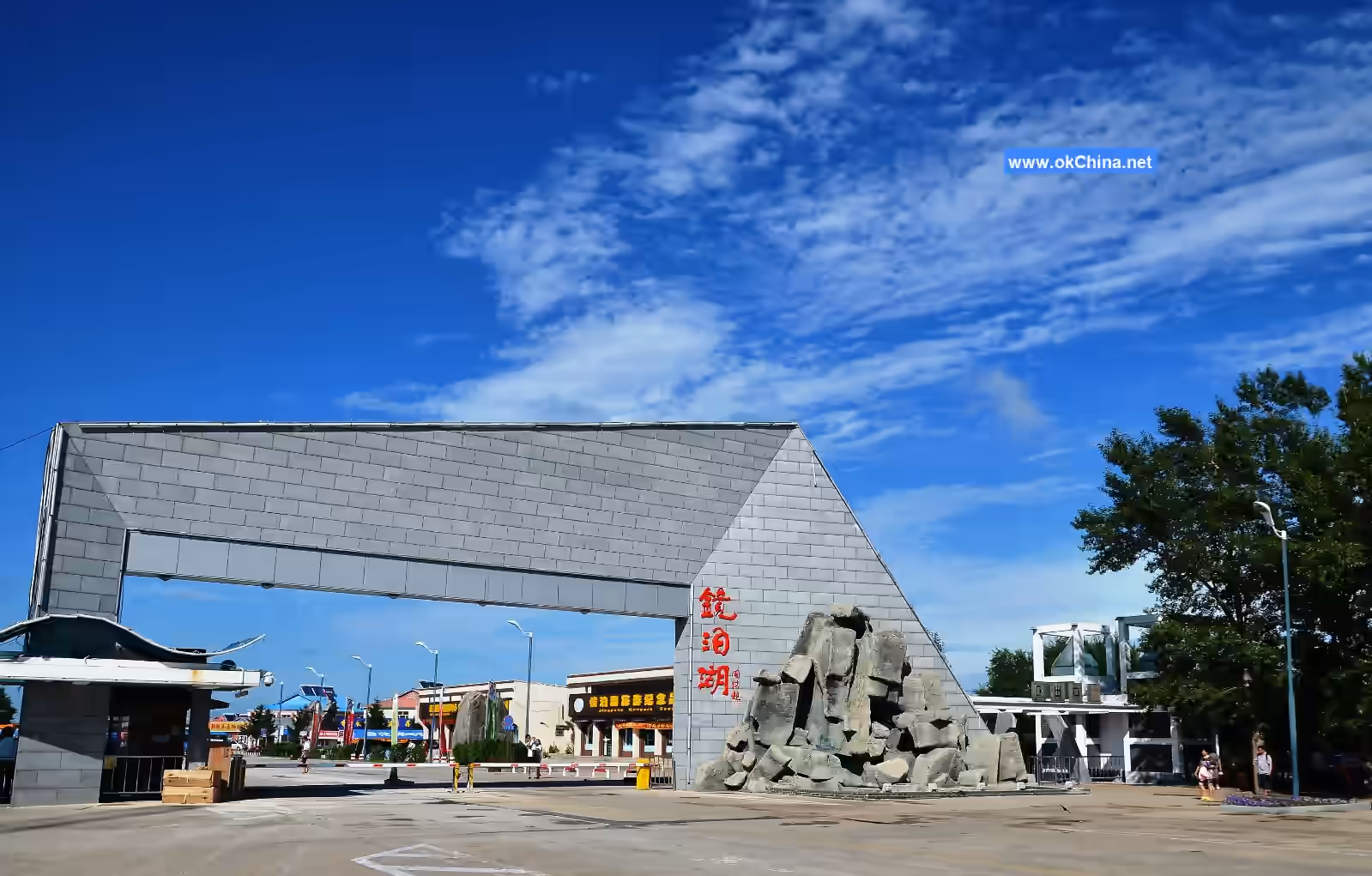
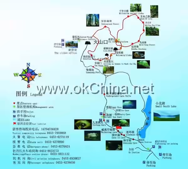
Jingpo Lake National Scenic Area is located between the Zhangguangcai Range and the Laoye Range in the southeast of Mudanjiang City, Heilongjiang Province. It lies 60 kilometers southwest of Ning'an City and 90 kilometers from downtown Mudanjiang. With a total planned area of 1,726 square kilometers, the scenic area consists of three main parts: the Hundred-Mile Long Lake, the Primeval Forest in Volcanic Craters, and the Site of the Shangjing Longquanfu of the Bohai Kingdom. It is comparable to the Thousand Island Lake, featuring sandstone sculptures and the charm of Tu'er Ridge. Jingpo Lake is primarily known for its lake and mountain scenery, complemented by geological wonders such as the underground primeval forest in volcanic craters and underground lava tunnels, as well as historical and cultural landscapes represented by the Tang Dynasty Bohai Kingdom ruins. It is a comprehensive scenic area suitable for scientific research, summer retreats, sightseeing, tourism, vacations, and cultural exchange activities. Jingpo Lake is like a dazzling pearl embedded in the northern frontier of the motherland, renowned worldwide for its unique and unadorned natural beauty, attracting an increasing number of domestic and international visitors. The park's landscape resources include lakes, rivers, waterfalls, wetlands, volcanoes, lava plateaus, underground lava tunnels, primeval forests, wildlife habitats, ancient city ruins, and ethnic folk customs. It integrates history, culture, flora and fauna, archaeology, geology, aesthetic value, and biodiversity, making it rare in China. There are 72 scenic resource points in Jingpo Lake, including 48 natural landscapes (67%) and 24 cultural landscapes (33%).

2. Geographical Environment

2.1 Geographical Location

Jingpo Lake Global Geopark and Jingpo Lake National Scenic Area (hereinafter referred to as Jingpo Lake Scenic Area) are located in Ning'an City, in the southeast of Heilongjiang Province and the southwest of Mudanjiang City (east longitude 120°30′–129°30′, north latitude 43°46′–44°18′). It serves as the endpoint of the Harbin–Yuquan–Yabuli–Dahailin China Snow Town–Jingpo Lake tourist route and is an important tourist destination in Heilongjiang Province. From a broader perspective, Mudanjiang–Jingpo Lake is at the center of the Northeast Asia tourism circle. To the southeast is the Russian port city of Vladivostok; to the south and southwest are the Changbai Mountain Tianchi Tourist Area in Jilin Province and the Songhua Lake Tourist Area at the source of the Songhua River; to the west lie famous scenic spots and cities such as Dahailin China Snow Town, Yabuli Ski Resort, Yuquan Hunting Ground, Harbin, and Wudalianchi. These constitute Jingpo Lake's uniquely advantageous geographical environment. Jingpo Lake is located on the main stream of the Mudan River, about 80 kilometers north of Mudanjiang City. It is about 130 kilometers east of Suifenhe, borders Dunhua City of Jilin Province to the south, and is 250 kilometers from Changbai Mountain. To the west lies Hailin City. Jingpo Lake stretches 45 kilometers from north to south, with a maximum width of 6 kilometers from east to west and a minimum width of 300 meters. Its water area covers 80 square kilometers, with a storage capacity of 1.6 billion cubic meters, and a forest coverage rate of over 68%.

2.2 Climate Characteristics

Heilongjiang Jingpo Lake National Geopark features a temperate continental monsoon climate with four distinct seasons: dry and windy springs; warm and rainy summers; short, sunny autumns; and long, cold winters. The annual average temperature is 3.6°C, with a maximum of 36.2°C and a minimum of -36.7°C. The average annual rainfall is 506.4 mm, with the longest continuous rainfall lasting 7–8 days. There are about 100 rainy days per year, concentrated in July and August. The average frost period in the area is from October 19 to April 28 of the following year, with an average of 172.7 snowy days per year. Early frost appears in late September, and late frost ends in early May, with a frost-free period of about 150 days. The area experiences frequent southwest winds in spring and northwest winds in winter. The prevailing wind direction throughout the year is southwest, with a calm wind frequency of 30.3%. The strongest winds generally occur in March and April, while the weakest winds are in June and July. The annual average wind speed is 2.9 m/s. The average lake freezing period begins on December 10, and the average lake thawing period is on April 20. The average ice thickness on the lake is 0.83 meters, and the average soil freezing depth is 1.42 meters. From May to September each year, the average temperature ranges from 10°C to 20°C.

2.3 Geological Features

The Jingpo Lake mountain range is located in the transitional area between the Zhangguangcai Range and the Laoye Range of Changbai Mountain, characterized by low mountain and hilly terrain. The mountains west of the lake have significant undulations, while those to the east and south are relatively gentle. North of the lake is a lava plateau with flat terrain. The northern part of the Jingpo Lake Scenic Area features complex topography, with 12 volcanic craters of varying sizes distributed across the area. The highest peak in the range is 1,260.7 meters above sea level (Laobei Mountain west of Luyuan Island), and the lowest elevation is 339.17 meters (the lowest water level elevation). The geological structure of Jingpo Lake mainly consists of granite, perlite, and basalt. The volcanic group in the northwest of the park has been erupting continuously for one million years, forming a basalt plateau over a hundred miles long. Around 4,800 years ago, the last volcanic eruption blocked the Mudan River channel with lava, creating the world's largest volcanic lava-dammed lake—Jingpo Lake—as well as a series of other lakes such as Xiaobeihu Lake, Zhuanxin Lake, and Yuanyang Pool.

2.4 Hydrological Features

The Jingpo Lake water system includes about 30 rivers, which converge into the lake in a centripetal pattern. Most of these rivers are mountain streams with rapid flow, high runoff concentration and dispersion rates, low sediment content, large annual runoff, significant seasonal flow variations, and long ice periods. Jingpo Lake is 45 kilometers long from north to south, with a maximum width of 6,000 meters from east to west and a minimum width of 300 meters. The general width ranges from 500 to 1,000 meters, with a maximum depth of 70 meters (in the northern waters of Jingpo Lake). The water surface area is 79.3 square kilometers, with a storage capacity of approximately 1.6 billion cubic meters. The second-largest lake, Xiaobeihu Lake, is about 6,000 meters long and covers a water area of 3.80 square kilometers. The intra-annual water level variation characteristics of Jingpo Lake are as follows: the highest water level usually occurs from August to September, and the lowest water level from March to April. The multi-year average water level is 347.95 meters, with the highest recorded at 354.43 meters and the lowest at 339.17 meters. Jingpo Lake's water originates from the Mudan River, which originates from the Mudan Ridge of Changbai Mountain in Jilin Province. The river has a steep gradient, and Jingpo Lake is about 300 kilometers from the source of the Mudan River, with a drop of approximately 750 meters.

3. Main Attractions

3.1 Volcanic Geological Landscapes

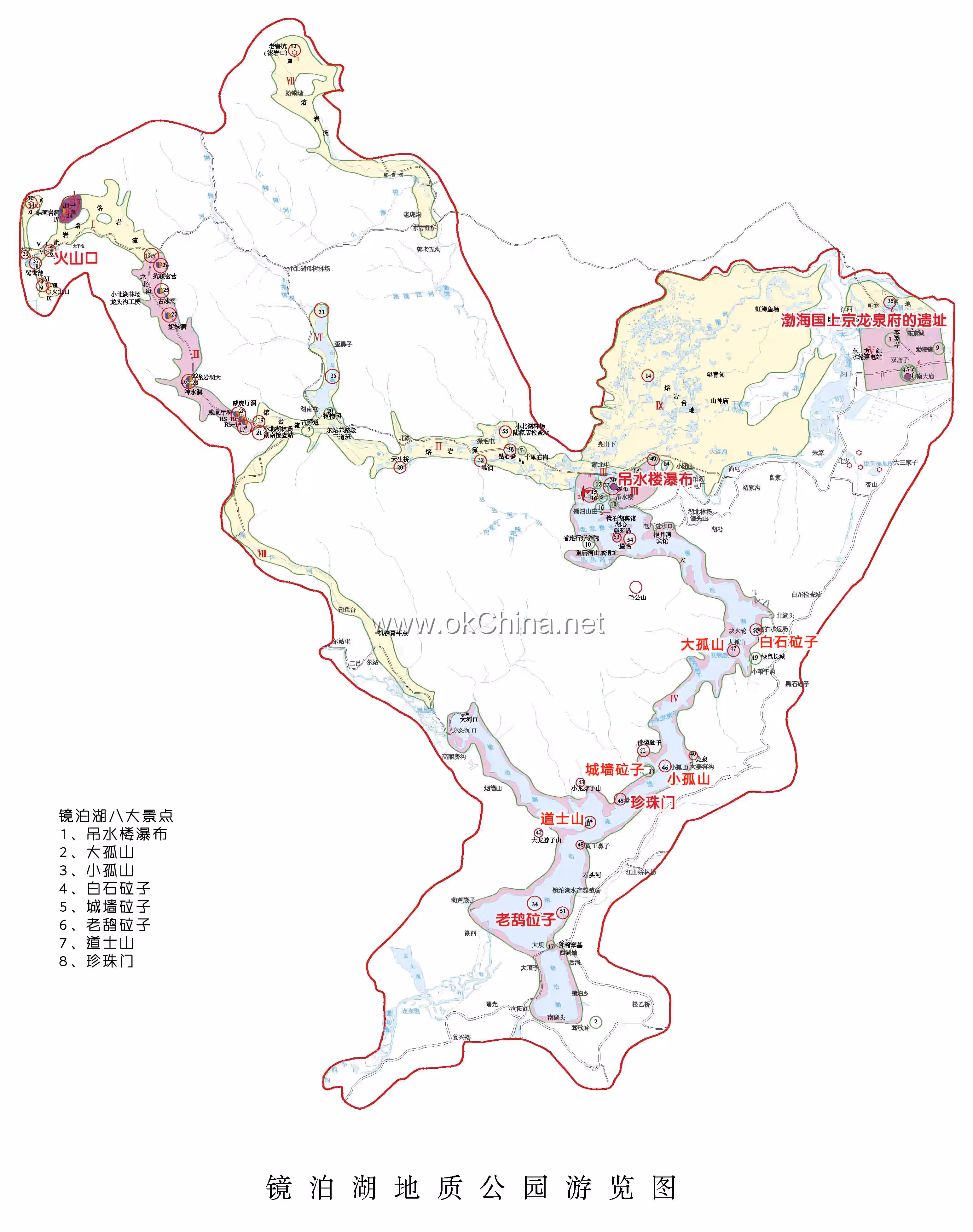
Within a 40-kilometer radius in the northwest of the Jingpo Lake Scenic Area, 12 volcanic craters of varying sizes are distributed. The diameters of these craters range from 70 to 550 meters, with depths between 30 and 132 meters. The volcanic group has been erupting continuously for one million years until the last eruption around 4,800 years ago. The lava rivers and lava plateaus outside the Jingpo Lake volcanic cones are mainly composed of black basalt. The plateaus are home to large-scale lava tunnels, rare in China, with similar internal structures and peculiar shapes. The longest lava cave can extend up to 10,000 meters, making it the largest and most complete lava tunnel discovered in China to date. Even in midsummer, ice scenes can be seen inside the caves, with a chilling cold. Some caves are shrouded in mist, deep and mysterious, holding significant scientific research value. No systematic investigation and research have been conducted by experts so far. The lava plateaus also feature various unique volcanic lava landscapes, such as lava bridges. Due to the ancient and varied volcanic eruptions, combined with Jingpo Lake's superior geographical environment, the volcanic craters are now covered with dense primeval mixed coniferous and broad-leaved forests and pure Korean pine forests, also known as "underground forests." The peculiarity of the landscape and the grandeur of the scenery are rare in China.

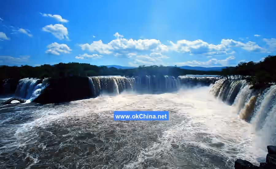
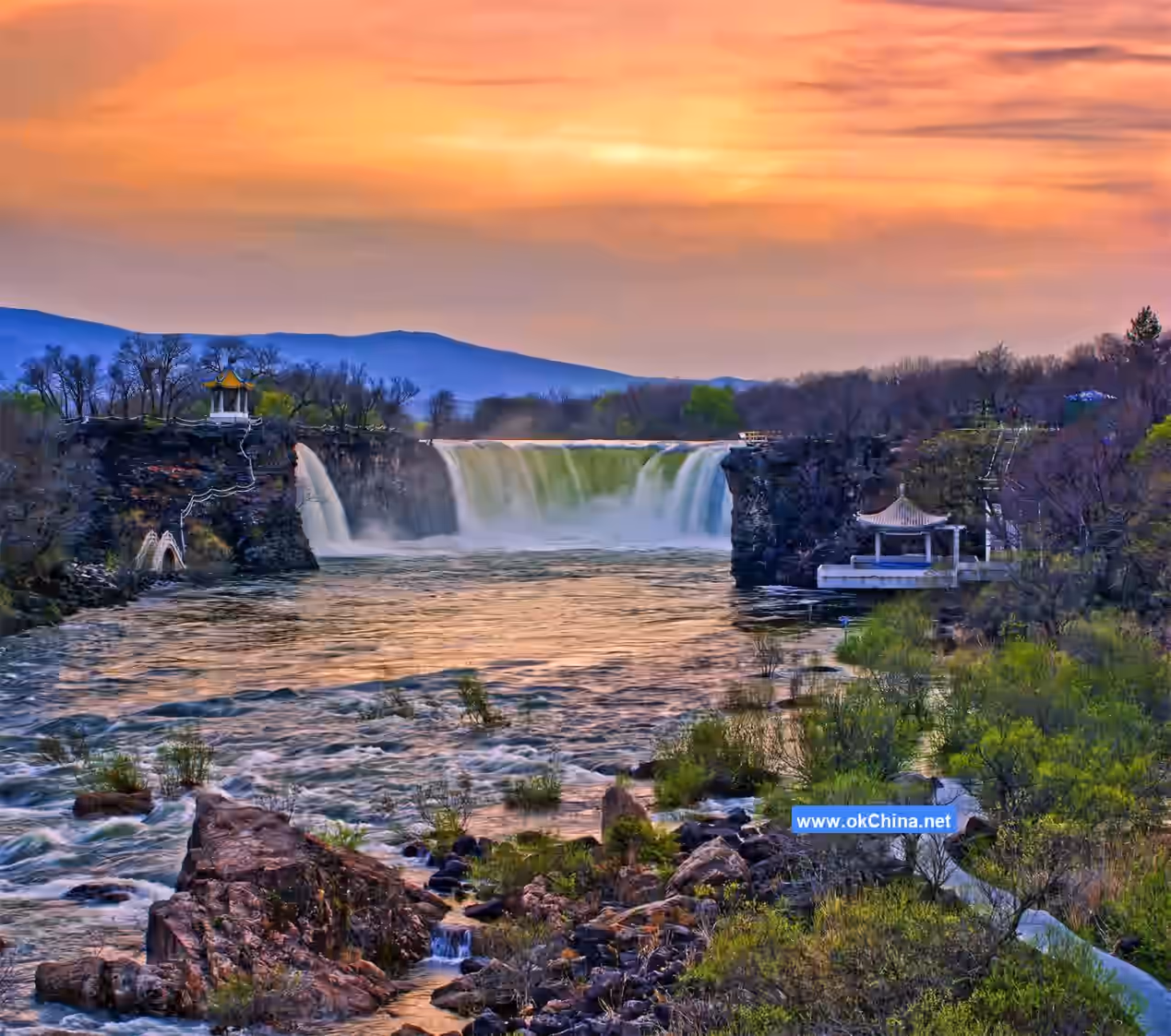
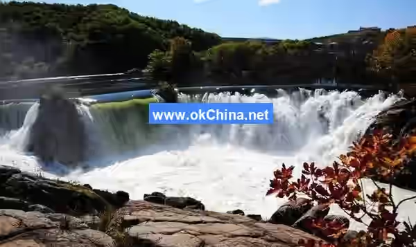
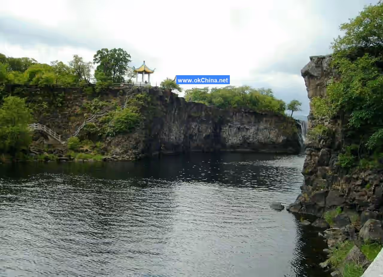
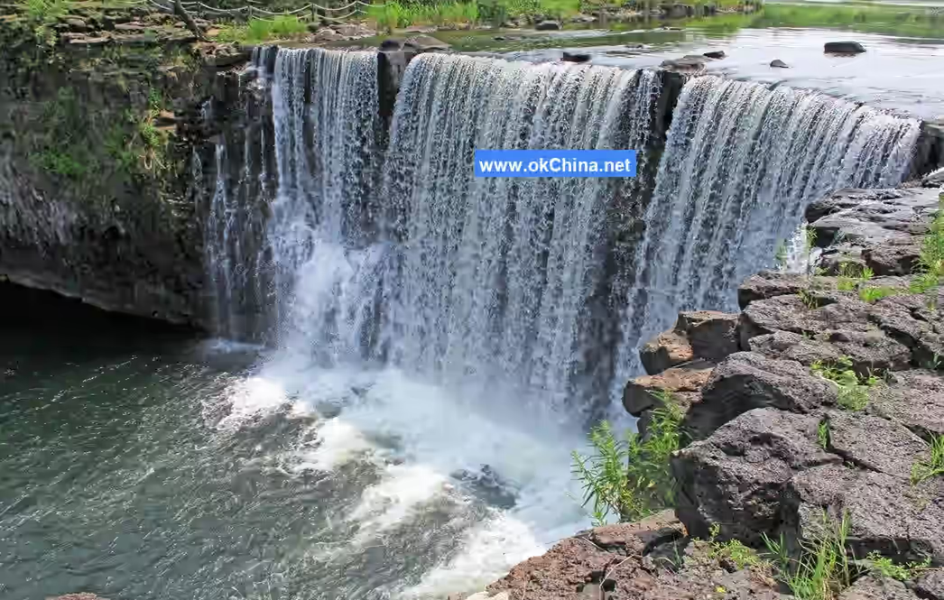
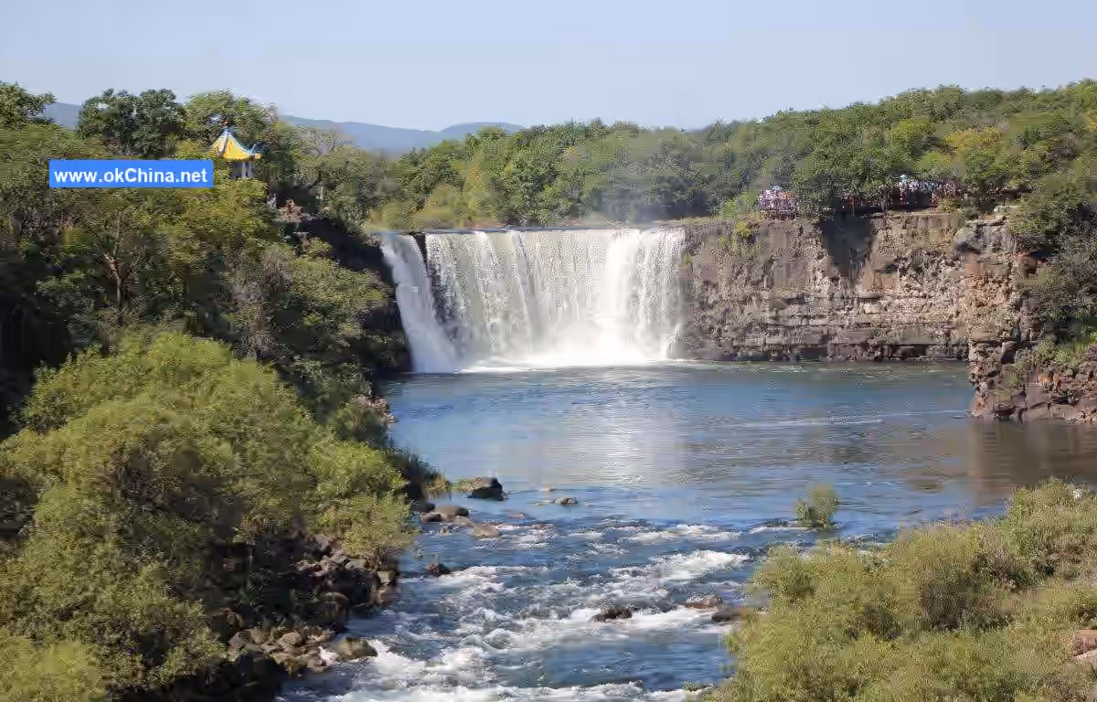
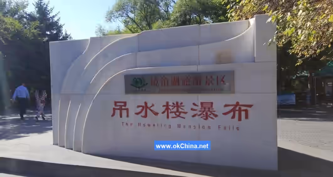
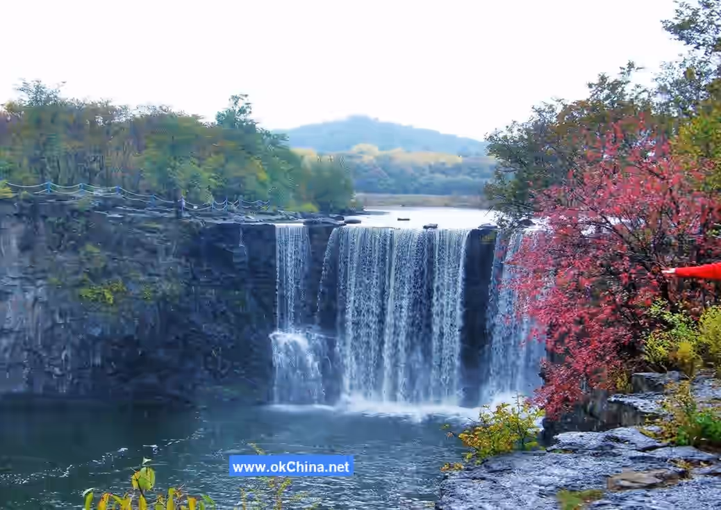
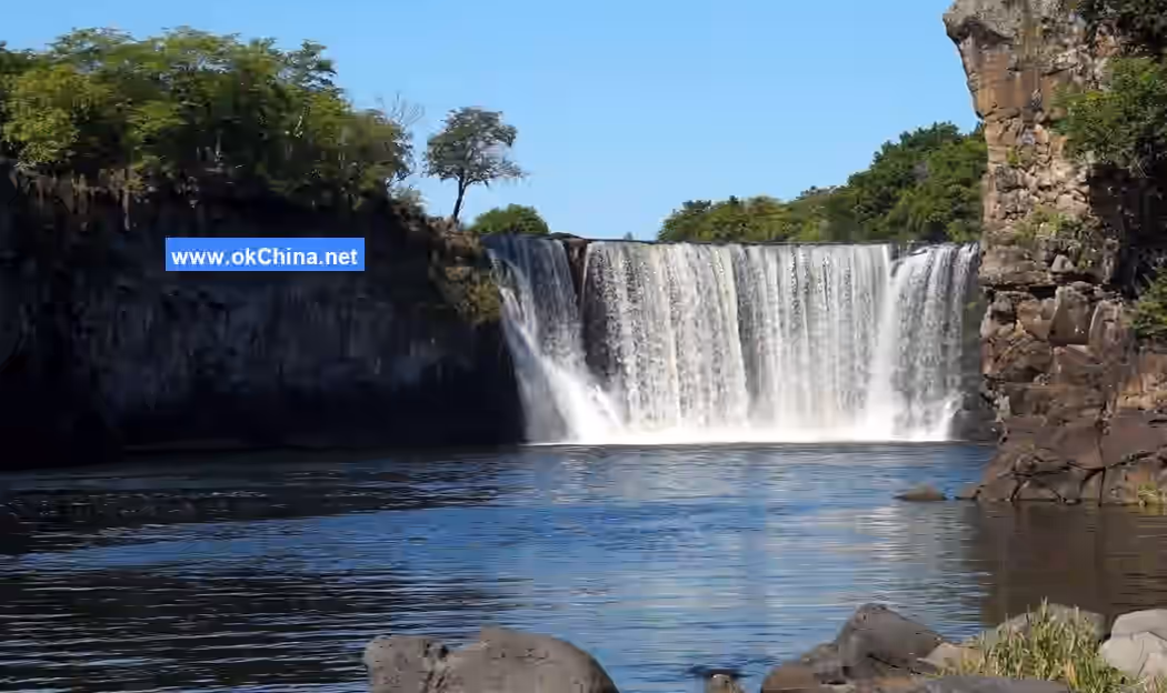
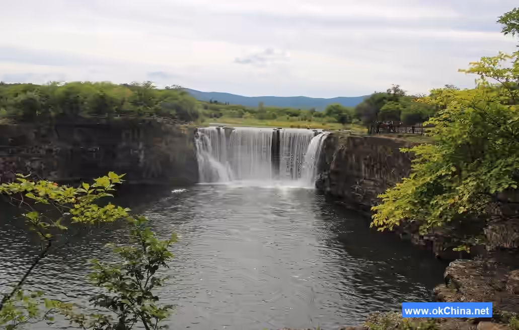
3.2 Diaoshuilou Waterfall

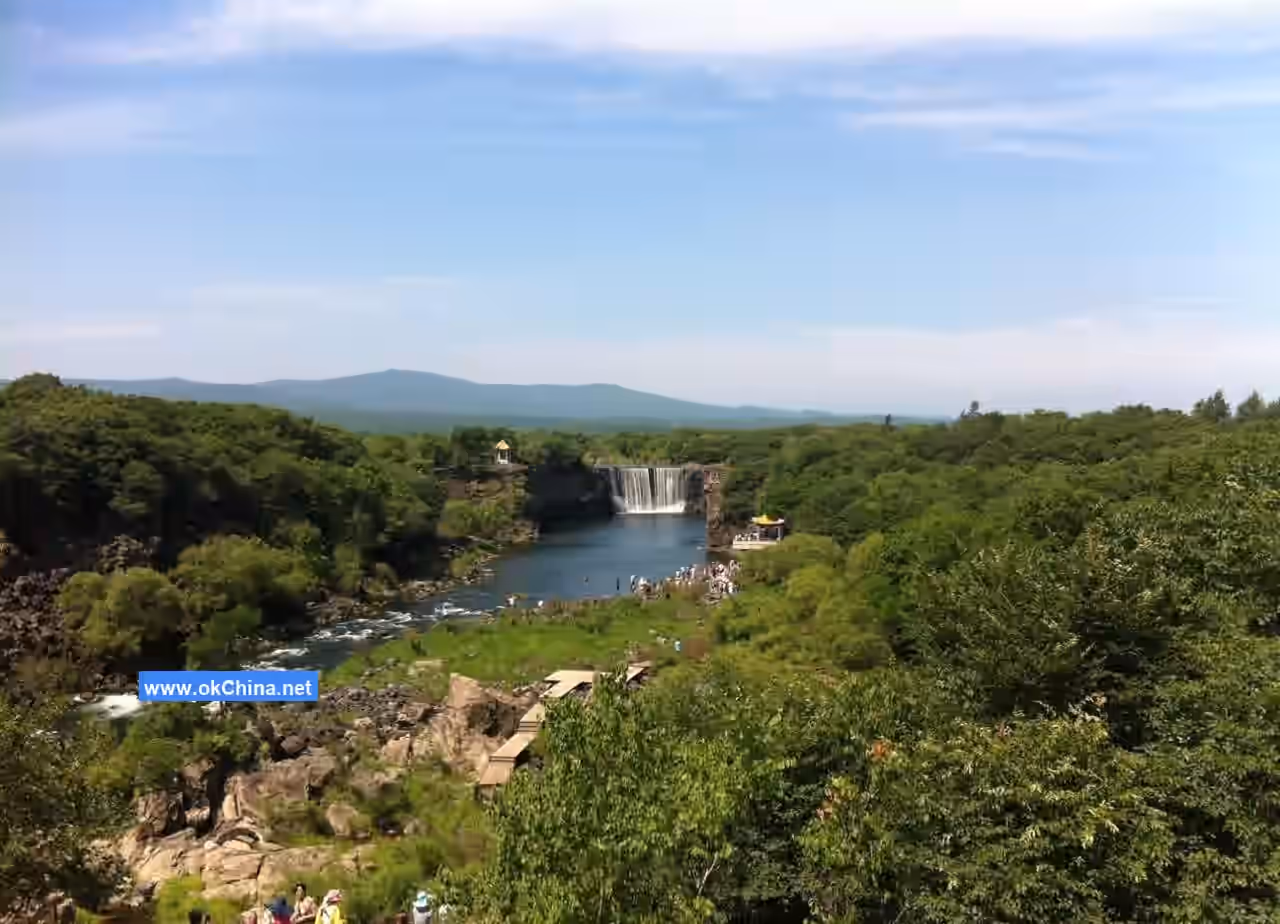
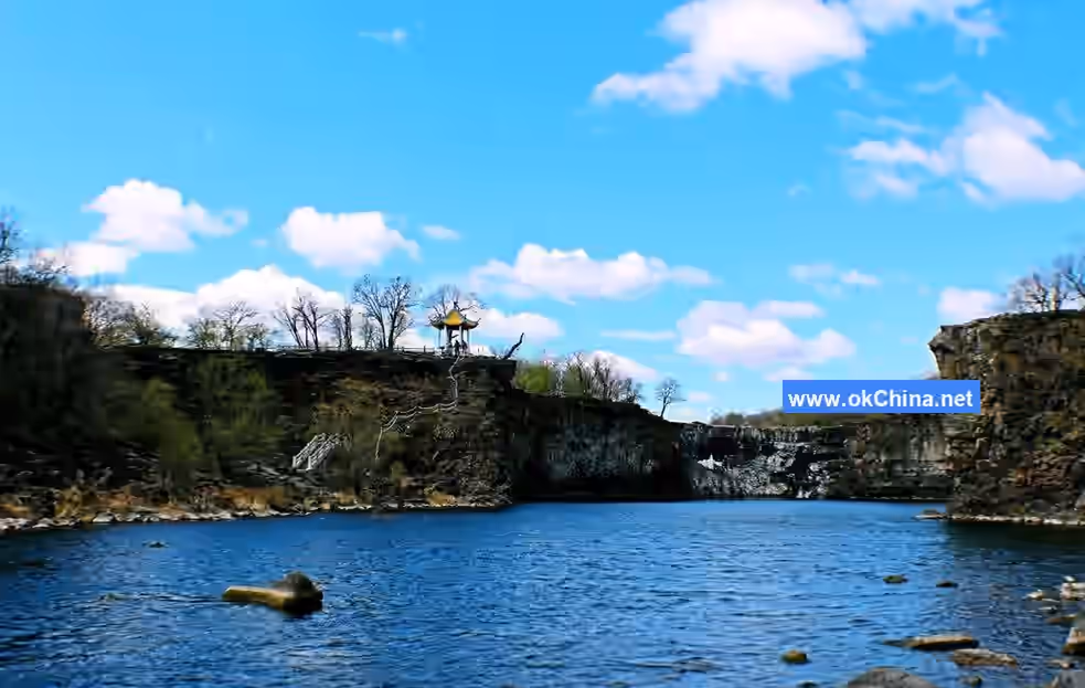
Diaoshuilou Waterfall is located at the northern end of Jingpo Lake. It is a special-grade natural scenic resource (world-class) in the scenic area, resembling the world-famous Niagara Falls. During normal water periods, the waterfall is generally 50–60 meters wide with a drop of 12 meters. However, during flood seasons, the maximum drop is only over ten meters, while the maximum width can exceed 400 meters. The waterfall cascades into the Heilongtan (Black Dragon Pool) from the southern, western, and northern directions with an overwhelming force, resembling piled-up clouds and snow, with white mist splashing everywhere. Water droplets can be felt over a hundred meters away. It also looks like a hanging Milky Way or a colorful ribbon on a cliff, roaring and thundering. It is known as one of China's six famous waterfalls, alongside Huangguoshu Waterfall in Guizhou, Hukou Waterfall of the Yellow River, Nuorilang Waterfall in Jiuzhaigou, Wenlong Waterfall in Taiwan, and Sandie Spring Waterfall in Lushan.

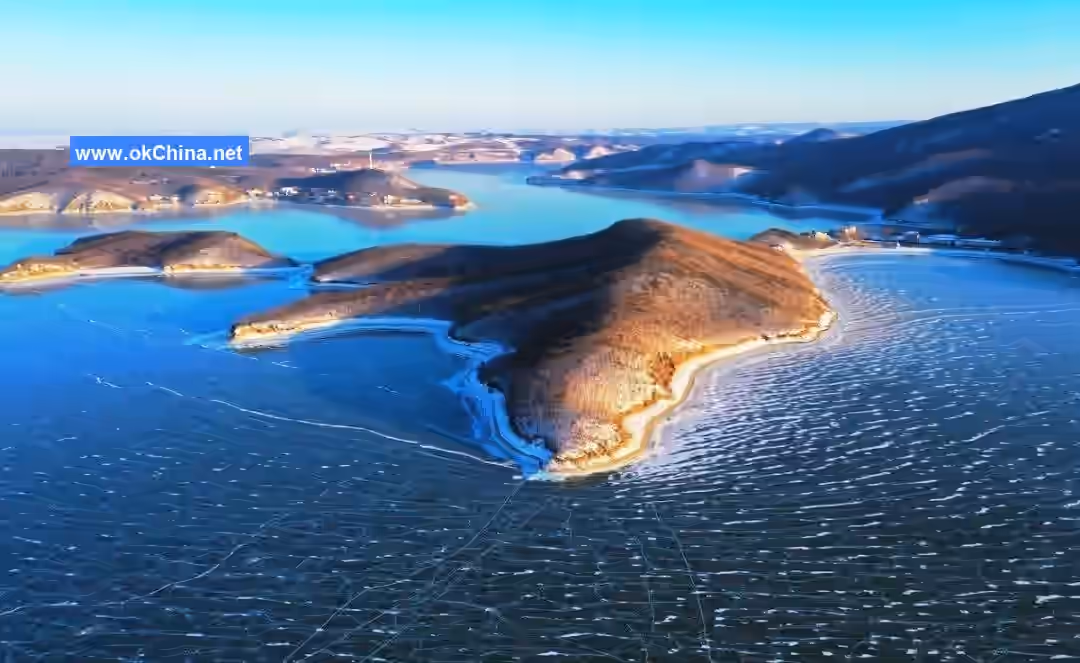
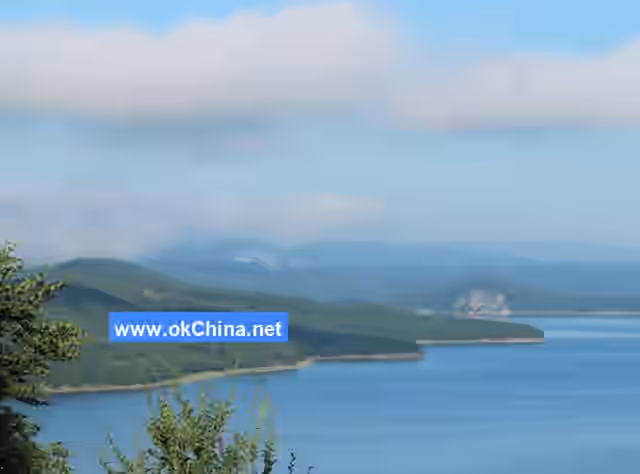
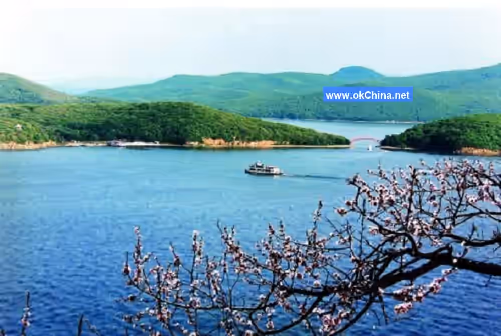
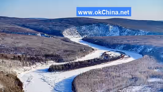
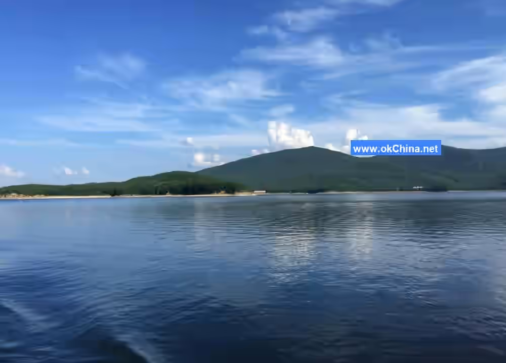
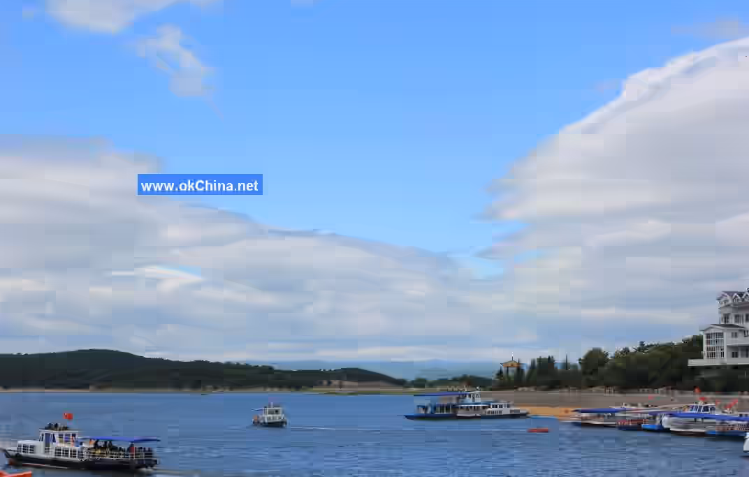
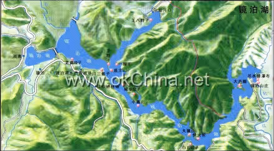
3.3 Hundred-Mile Long Lake

The Hundred-Mile Long Lake is one of the three core scenic areas of Jingpo Lake Scenic Area. It winds in an "S" shape and is divided into four parts: North Lake, Middle Lake, South Lake, and Upper Lake. Stretching 45 kilometers (about 100 Chinese miles) in length, it is called the Hundred-Mile Long Lake. The water area of Jingpo Lake is 79 square kilometers, expanding to 90.3 square kilometers during the high-water season, with a total storage capacity of 1.62 billion cubic meters. It is the world's largest volcanic lava-dammed lake. Around 10,000 years ago, after five volcanic eruptions, lava blocked the ancient Mudan River channel, forming a natural lava dam and creating the early Jingpo Lake. Around 70,000 years ago, at the end of the Late Pleistocene, another large-scale volcanic eruption occurred, forging an even wider lava dam and gradually forming the world's largest volcanic lava-dammed lake. It is a special-grade natural scenic resource (world-class) in the scenic area. The lake features numerous first-grade (national-level) natural scenic resources on the water, such as Baishilazi, Big Solitary Island, Small Solitary Island, Huzhou City, Pearl Gate, Taoist Mountain, and Laogualazi.

3.4 Mao Gong Mountain

Mao Gong Mountain is located on the east side of Laobei Mountain, facing the Leader's Building of Jingpo Lake Villa across the lake. It is a first-grade natural scenic resource (national-level) in the Jingpo Lake Scenic Area. This landscape is formed by the overlapping of two mountain ranges, resembling Comrade Mao Zedong lying on his back as depicted in the "Memorial Hall." The figure is 4 kilometers long, with clear facial features and well-proportioned body parts.### 3.5 Huzhou City Huzhou City, also known as Chengqiang Lazi, is located in the central-southern part of the Hundred-Mile Long Lake. It is a first-class cultural landscape resource (national level) within the scenic area. This landscape consists of three large, terraced peaks, with the highest peak reaching an altitude of 524 meters. Surrounded by the lake on three sides, it is essentially a large peninsula. The ridge of this landscape winds and coils like a screen, featuring towering cliffs, rugged rocks, a gathering of spectacular peaks, a thousand cliffs vying in splendor, sheer precipices forming a natural barrier that is easy to defend but hard to attack. Over 1300 years ago, between 698 and 926 AD during the Bohai Kingdom period, an ancient city was built on this mountain to defend against invasions by the Khitan people.

3.6 Xinglong Temple

Xinglong Temple, also known as Nandamiao (Great Southern Temple), is located in the northeastern part of Jingpo Lake. It was an important architectural structure of the Shangjing Capital of the Bohai Kingdom during the Tang Dynasty and is a first-class cultural landscape resource (national level) within the scenic area. Xinglong Temple has a long history and preserves many valuable cultural relics, such as the Stone Lantern Stupa and the Large Stone Buddha. The most famous is the Stone Lantern Stupa, renowned both domestically and internationally, making it a world-class cultural landscape resource. The Stone Lantern Stupa is a famous Buddhist stone carving artifact from the Bohai Kingdom period, embodying both the typical carving and architectural artistic styles of the Tang Dynasty and the characteristics of Bohai stone carving art. It represents one of the achievements of the spread of the prosperous Tang Dynasty's stone carving art to the northeastern region. It is not only a representative work of Bohai Kingdom period stone carving art but also a typical representative piece of ancient Chinese stone carving art.

3.7 Glazed World

Glazed World, commonly known as Buddha Cliff or also called Thousand Buddha Cliff, is located on the north side of the Chengqiang Lazi Gully entrance in the middle lake of Jingpo Lake, about 1000 meters away from Chengqiang Lazi. The cliff has an altitude of 423.7 meters, is over 130 meters wide, and is pyramid-shaped. Its northern side consists of continuous mountain ranges covered with forests, extending deep and far. The southern side (front) of Glazed World was recognized by Venerable Shi Yicheng, President of the Buddhist Association of China, as the "Eastern Pure Glazed World." Glazed World is the natural sacred site of the Seven Medicine Buddha Masters (Bhaisajyaguru). Among numerous Buddhist mountains, it holds an unshakable leading position.

4. Cultural Resources

4.1 Historical Culture

In the "Book of Han · Treatise on Geography," Jingpo Lake was referred to as the Meituo River. In the second year of the Yonghui era of Emperor Gaozong of Tang (652 AD), it was called the Abu River (also known as Abu Long Lake) and later referred to as Hurhaijin. In the first year of the Kaiyuan era of Emperor Xuanzong of Tang (713 AD), it was called Huhanhai. Records from the Ming Dynasty began calling it Jingpo Lake; the Qing Dynasty called it Bier Teng Lake; today it is still called Jingpo Lake. In 755 AD, the Bohai Kingdom moved its capital from within present-day Jilin Province to today's Bohai Town, establishing its capital "Shangjing Longquan Fu." In 928 AD, the Bohai Kingdom was destroyed by the Khitan, and its capital was ruined.

Historically, the residents around Jingpo Lake were primarily the Sushen people and their descendants. According to Chinese historical records: "In the 15th year of King Wu of Zhou (1666 BC) and the 9th year of King Cheng of Zhou (1654 BC), the Sushen people came to court to offer tribute." The Yilou of the Western Han, the Wuji of the Northern Wei, the Mohe of the Sui and Tang dynasties, the Jurchen of the Song and Yuan dynasties, and the Manchu are all descendants and branches of the Sushen people. During the War of Resistance against Japan, the Japanese conducted several surveys around Jingpo Lake, engaged in logging, excavated cultural relics and historical sites, and built a power plant. Anti-Japanese allied heroes were also active in this area. After liberation, the main residents here have been Han Chinese, Koreans, and Manchus.

4.2 Cultural Relic Resources

Within the Jingpo Lake scenic area, there are sites from the Neolithic Age, such as the Yinggeling Culture (located at Yinggeling. Sushen people lived here; there are cave dwelling sites and unearthed artifacts) and the Pearl Gate Site (located at Pearl Gate. Sushen people lived here; there are semi-underground cave dwellings). There are also sites from the Tang Dynasty Bohai Kingdom's Shangjing Longquan Fu (located in Bohai Town. Built by the Tang Bohai Kingdom, modeled after the Chang'an capital, with outer, inner, and palace cities and five layers of halls, grand in scale. The original city layout and architectural ruins can still be seen, along with cultural relics like the Stone Lantern Stupa and Stone Buddha). Other sites include the Chongchunhe Mountain City Site (located at Chongchunhe. Built by the Bohai Kingdom for defense against Khitan invasions; existing city wall architectural ruins remain), the Huzhou Mountain City Site (located on the west bank of Xiaogushan, also known as Chengqiang Lazi. Built by the Bohai Kingdom for defense against Khitan invasions; existing granite city wall remnants, architectural ruins, ancient well site, and training ground site), the Xihuzuizi Mountain City Site (located in South Lake), the Xiaochengzi Mountain City Site (located at South Lake Head), the Chujia Mountain City Site (located at Chujia, South Lake Head), the Small City Wall Site (located at Jiangshanjiao Forest Farm. Built by the Bohai Kingdom for defense against Khitan invasions), and the Jingpo Border Wall Site (located at the Aquaculture Farm). There is also the Dongxia Kingdom's Chengzihou Mountain City Site from the Song Dynasty (located downstream of the waterfall. The only Dongxia Kingdom relic in the province; only the city wall architectural ruins and an abandoned well remain). From the Qing Dynasty, there are Xinglong Temple (located in Bohai Town. Built on the site of a Bohai Kingdom temple; five-hall wooden structure, well-preserved, now used as a cultural relic exhibition hall) and Sanqing Temple (located on Daoshi Mountain. The site is well-preserved).

4.3 Folk Legends

The first legend dates back to ancient times. One year on the third day of the third lunar month, the Queen Mother of the West held a Peach Banquet. Deities from all directions attended, and the lively festivities lasted for 33 days. The goddesses washed and adorned themselves, and the rouge water they poured into the Heavenly River kept increasing. As a result, the Heavenly River swelled and flowed into the lofty mountains and steep ridges upstream of the Mudan River, converging into a large lake that seemed to flow with gold and silver. While the immortals were washing their faces, one deity accidentally knocked over a precious mirror, which fell into the lake with its mirror surface facing upwards. It sparkled on the vast, misty lake, and no matter how strong the wind blew, there were no waves on the lake. When the Queen Mother of the West learned of the loss of the precious mirror, she was furious and urgently ordered the Thunder God and Thunder Goddess to search for it. With flashes of lightning and peals of thunder, they finally found the mirror in Jingpo Lake near Ning'an County. The Queen Mother descended to the lakeside and, captivated by the green mountains, clear waters, and serene environment, decided to leave the precious mirror there.

The second legend tells that Jingpo Lake is said to have been formed from the precious mirror of the Red Silk Maiden. The Red Silk Maiden was a beautiful maiden from antiquity who often used the divine light of her precious mirror to avert disasters and bring benefits to the people. Later, this precious mirror was seized by the Queen Mother of the West. While the Red Silk Maiden ascended to heaven to contend for it, she accidentally dropped the mirror onto the mortal world. It then transformed into the splendidly scenic Jingpo Lake volcano. The actual cause of the Jingpo Lake volcano is naturally not as romantically enchanting as the mythologized version. But it is indeed a magical landscape!

Comments

Post a Comment

Loading comments...