


Mount Jinfo
1. Introduction
The Mount Jinfo Scenic Area is located south of Nanchuan District in the southern outskirts of Chongqing. Mount Jinfo, also known as Mount Jin, was historically called Mount Jiudi. It belongs to the northernmost end of the Dalou Mountain Range, with its main peak, Fengchui Ridge, being the highest peak of the Dalou Mountains at an elevation of 2,238.2 meters. Mount Jinfo lies near the mysterious 30°N latitude, alongside Mount Everest, the Mayan civilization, and the Egyptian pyramids. It boasts three wonders: a Karst World Natural Heritage site, rich biodiversity, and Buddhist culture.
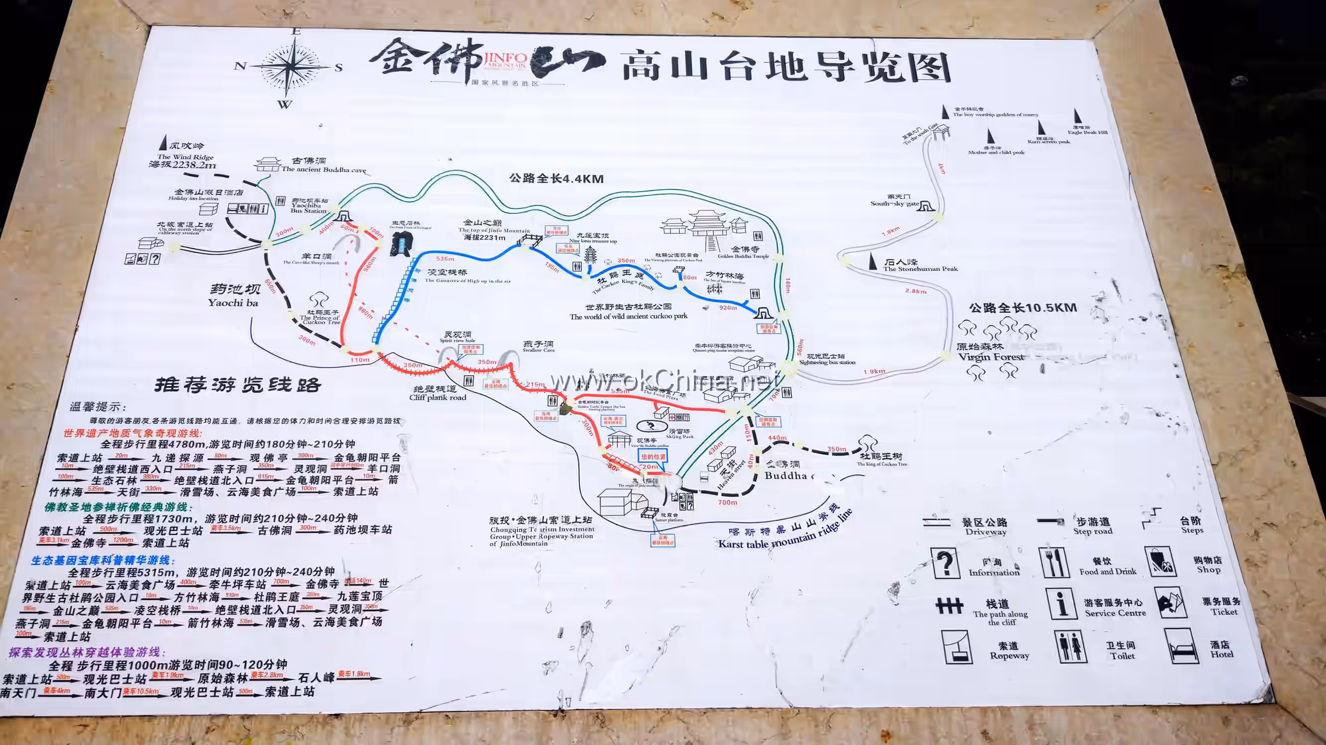
Mount Jinfo comprises three mountains: Jinfo, Baizhi, and Qingba. Its scope covers the entire southern part of Nanchuan District, with a total area of 1,300 square kilometers, accounting for half of Nanchuan's total area. Within this, the planned scenic area covers 441 square kilometers, with a core area of 66 square kilometers. The natural landscapes of Mount Jinfo primarily include sheer cliffs, canyons, peculiar peaks, karst caves, ecological stone forests, springs and waterfalls, as well as meteorological phenomena.
2. Geographical Environment
2.1 Location and Territory
The Mount Jinfo Scenic Area is situated south of Nanchuan District in the southern outskirts of Chongqing, with geographical coordinates of 107°27′ E and 28°52′ N. It borders Daozhen County, Zheng'an County, and Tongzi County of Guizhou Province to the south; Banan District and Wansheng District to the west; Wulong District to the east; and adjoins Nanchuan District to the north. Mount Jinfo belongs to the northernmost end of the Dalou Mountain Range, with its main peak, Fengchui Ridge, being the highest peak of the Dalou Mountains at an elevation of 2,238.2 meters.
2.2 Geology and Geomorphology
The geological structure of Mount Jinfo belongs to the Neocathaysian tectonic system, with exposed strata consisting entirely of sedimentary rocks. Its geomorphological features are characterized by deeply incised mid-mountain plateaus and low-mountain gorges, falling under the Southern China Karst landscape. Mount Jinfo's karst topography has two main types: Above 1,000 meters elevation, with relative height differences of 500-1,000 meters, the landscape features majestic mountains, steep cliffs, and peculiar peaks and rocks. In areas between 800-1,200 meters elevation with relative height differences over 500 meters, the combination of Cambrian, Ordovician, and Silurian rock layers, with the towering Qixia limestone, creates magnificent scenery. Weathering, dissolution, and water erosion have formed unique low-mountain gorge landscapes. Due to its specific geological structure, numerous spectacular karst caves are found from the mountaintop to the foothills, with well-developed stalactites.
2.3 Climate
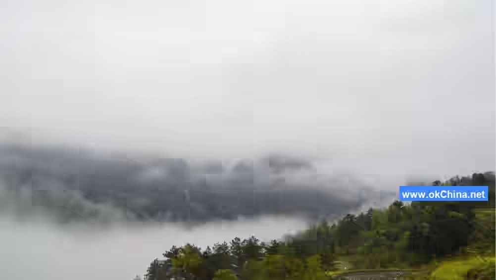
The Mount Jinfo Scenic Area has a humid and rainy climate. The annual sunshine duration is 1,079.4 hours, with the highest recorded in 1963 at 1,573 hours and the lowest in 1974 at 1,023 hours. At an elevation of 1,905.9 meters, the average annual temperature is 8.3°C, with average temperatures of 17.8°C in July and August. The average annual precipitation is 1,395.5 mm, concentrated mainly in summer. The highest annual rainfall reached 1,643.1 mm, while the lowest was 957.7 mm. In the mid-mountain plateau areas, the freezing and snow period lasts up to 4 months, typically starting with snowfall in mid-November, forming rime and glaze ice, and ending by March of the following year, with the latest recorded on March 29th. The average monthly relative humidity throughout the year is 90%, with the highest month reaching 98%.
3. Main Attractions
3.1 Natural Landscapes
3.1.1 Golden Buddha at Sunset
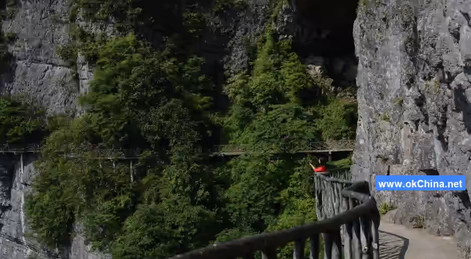
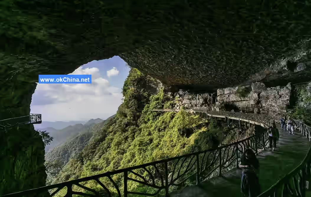
Golden Buddha at Sunset was ranked first among the "Eight Scenes of Nanchuan" during the Qing Dynasty and the Republic of China era. The eastern, northern, and western sides of Mount Jinfo's mid-mountain plateau feature continuous sheer cliffs stretching about 60 kilometers, with relative height differences of 200-300 meters. Along the cliffs from north to west, there are five giant karst cave entrances in sequence: Fairy Cave (entrance and exit), Ancient Buddha Cave, Lingguan Cave, and Swallow Cave, offering a grand panoramic view. The northern cliffs, combined with the main peak Fengchui Ridge and adjacent hilltops, form a silhouette resembling a reclining Buddha. During clear summer and autumn evenings, the setting sun illuminates the cliffs and rocks, making them glow resplendently like a golden Buddha radiating rays of light, hence the name Mount Jinfo (Golden Buddha Mountain). On clear days, this scene can be viewed from as far as Nanchuan District and as near as the area from Moziyan to Baiguolin.
3.1.2 Golden Turtle Facing the Sun
Golden Turtle Facing the Sun is located on the western mountain edge of Mount Jinfo's cliffs, at an elevation of 1,800-2,100 meters. It is a marvelous landscape formed by the western cliffs and the gentle slopes above. The gentle slopes consist of two hills, a larger one resembling an oval turtle shell and a smaller, elongated one like a turtle's head stretching forward. The cliffs form the edge of the turtle's body, creating a massive shape about 300 meters high and 500 meters long. When illuminated by the slanting sun, it resembles a golden turtle.
3.1.3 Emerald Pool Secluded Valley
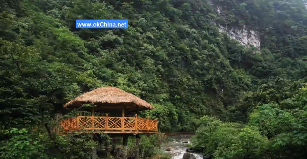
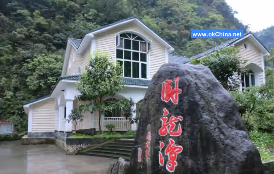
Emerald Pool Secluded Valley is located on the western foothills of Mount Jinfo, at the upper reaches of the Shizhong Stream. The canyon is about 4 kilometers long. The first 2.5 kilometers are relatively gentle, with steep walls 150-600 meters high, 5-15 meters wide, and an elevation of nearly 700 meters. The remaining 1.5 kilometers gradually ascend, reaching an elevation of over 1,300 meters. Here, the Emerald Pool for boating was created by an artificial dam. The pool is up to 6 meters deep at its deepest point, 40 meters wide at its widest, covering an area of 1 hectare. Upstream, attractions include Frog-Croaking Bridge, Yixin Pavilion, Mysterious Turtle Welcoming Guests, Beaded Pools, Liansheng Bridge, Dragon Claw Pass, Immortal Meeting Pavilion, Young Phoenix Bridge, Immortal Music Pavilion, Boulder Stream, Red Maple Autumn Splendor, and Frosty Leaf Bridge. The end of Emerald Pool Secluded Valley connects with the western slope hiking trail of Mount Jinfo. The total distance from the entrance to Qianniuping is 4 kilometers, making it the best walking route for ascending the western slope.
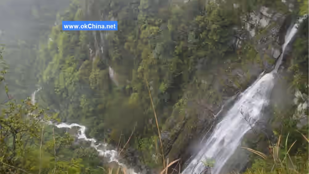
3.1.4 Dragon Cliff Flying Waterfall
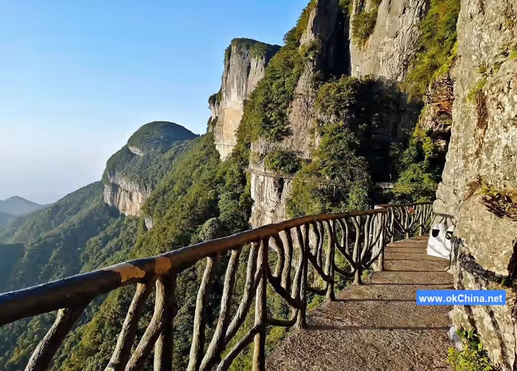
Dragon Cliff Flying Waterfall is located in the northeast of Mount Jinfo, at an elevation of around 800 meters. Layers of sedimentary rock walls on both sides form a canyon landscape, containing five flying waterfalls and flowing springs. Among them, Dragon Cliff Flying Waterfall flows year-round, while the other four are intermittent. At the entrance of the downstream Shiban Gully, there is the Lion Watching the Waterfall. Further along are attractions like Three-Step Waterfall, Fish Scale Strange Rocks, Water Yielding to Pedestrians, Heavenly View, Rock Deer Yearning for a Drink, Yin-Yang Pagoda, Cliffside Plank Walkway, Instant Enlightenment Buddha, and Ten Thousand Scrolls Book Platform.
3.1.5 Ten-Mile Gallery
Ten-Mile Gallery is located on the northern foothills of Mount Jinfo. It stretches 7.5 kilometers upstream along the Longgu Stream from Sanquan to Daheba, at an elevation of about 700 meters. The mountains on both sides are about 200-700 meters high, with a valley floor 15-50 meters wide. The canyon walls are rich in stalactites, with green moss and dripping water. Dense shrubs and bamboo groves grow in the crevices of the cliffs. Within the canyon is Taoyuan Cave, from which an underground river flows. The stream is 8-15 meters wide, with luxuriant Chinese wingnut trees growing among the boulders and gravel, creating picturesque scenery, hence the name "Ten-Mile Gallery."
3.1.6 Crouching Dragon Pool
Crouching Dragon Pool is located on the northern foothills of Mount Jinfo, in a tributary valley of the Longgu Stream. It is 5.5 kilometers long, with mountain walls 300-600 meters high on both sides and a valley floor 15-40 meters wide. At the entrance, there is a long, narrow pool, along with three other ponds raising giant salamanders weighing up to 25 kilograms and Schizothorax prenanti (Ya fish). At the far end of the pool is a feeding area for a tamed monkey troop, often frequented by over 100 macaques. The gorge contains two chain bridges and one cliffside plank walkway. Attractions include Tranquil Lake, A Thread of Sky, Jade Pool, Tiger Leaping Gorge, and Millennium Big Tree (Elaeocarpus japonicus).
3.1.7 Brocade Screen Peak
Brocade Screen Peak is located on a gentle slope halfway up the mountain in Yulin Village, Toudu Town. It features towering rock walls forming peaks and lower gaps forming ravines, totaling six peaks and five ravines. Below, a stretch of bare rock about 3,000 meters long connects them into a whole. Beneath the peaks and rocks, lush forests change colors with the seasons, resembling a giant screen standing at the southern gateway of Mount Jinfo.
3.1.8 Eagle Beak Peak
Eagle Beak Peak is located about 2,000 meters south of Gaoxuezi, at an elevation of around 1,600 meters. Three peaks stand side by side. The northern stone peak is about 300 meters high, with its bare rock face oriented eastward. Its top is prominent, shaped like the hooked beak of a giant eagle's head, with depressions in the rock resembling eyes. On either side of the stone peak, small hilltops and slopes are closely connected, resembling wings. The peak ridge and small hills are verdant with trees, while the lower part of the stone peak features grayish-white, steep rock faces, resembling the eagle's chest and belly.
3.1.9 Mother and Child Peaks
Mother and Child Peaks are located north of Eagle Beak Peak, at an elevation of around 1,500 meters. There are two stone peaks: the taller one is over 30 meters high, smaller at the top and wider at the base; the shorter one is over 20 meters high, with a rounded top and a slender base, leaning westward. The two peaks are closely connected, appearing from a distance like a mother and child.
3.1.10 Child Worshipping Guanyin
Child Worshipping Guanyin is located at the eastern end of the cliff at Gaoxuezi, at an elevation of 1,470 meters. A small hill about 30 meters high strongly resembles the Bodhisattva Guanyin. Not far below, a solitary rock stands tilted, shaped like a child facing Guanyin, hence the name "Child Worshipping Guanyin."
3.1.11 Stone Man Peak
Stone Man Peak (Stone Bamboo Shoot) is located on the side of Qiaochangheba on the southern slope of Mount Jinfo, at an elevation of around 1,700 meters. A solitary peak stands over 50 meters tall, strikingly resembling a human figure. Nearby is a large rock resembling a horse's head, leading to the name "Stone Man with Horse Face." In the 1970s, during the construction of the southern slope road, one ton of black powder was placed beneath Stone Man Peak intending to blast it away, but it only damaged the surface. Later, construction workers considered it a divine peak, so it has been preserved to this day.
3.1.12 Candlestick Peak
Candlestick Peak is located in the middle section of the Baizhi Stream Grand Canyon near Toudu Old Market's upper entrance, at an elevation of nearly 700 meters. It is about 50 meters high, divided into upper and lower sections. The lower section resembles a candlestick, creating the spectacle of two waterfalls cascading down in front and behind.
3.1.13 Thumb Mountain
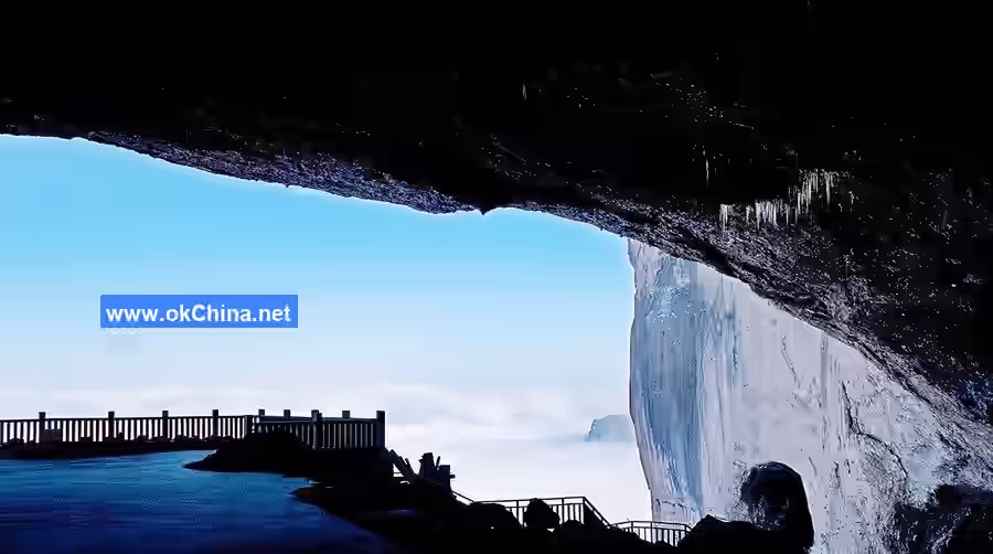
Thumb Mountain is located over 2,000 meters southeast of Longyan City, with both large and small versions. Small Thumb Mountain is over 700 meters high, with an elevation of about 1,900 meters. It stands majestically alone, with a sharp and perilous summit and deep, beautiful forests at its base. It can be viewed along the road from Longyan City to Dayou Town. Large Thumb Mountain is located on the southeastern foothills of Mount Jinfo, at the border of Qingyuan Township and Guhua Township, with an elevation of about 1,800 meters. This solitary peak stands upright, shaped like a thumb. It can be viewed from afar along the road from Qingyuan Township through Guhua Township to Delong.#### 3.1.14 Ancient Buddha Cave The Ancient Buddha Cave is located on the mountaintop, northeast of the Yaochi Dam, at an altitude of 2,100 meters. The entrance is about 5 meters high and 3 meters wide. Passing through a narrow passage on the left side of the cave leads to a "great hall" covering one hectare, featuring attractions such as an ancient Buddha, a stone coffin, a rice market, and an opera tower. Proceeding left for over 400 meters, the cave gradually narrows, forming a large, artificial tunnel-like passage that slopes upward to an exit on the sheer cliff face directly north of Jinfo Mountain. This exit is about 20 meters high and 40 meters wide, shaped like a crescent moon. From here, one can gaze into the distance, with the peaks of the northern slopes beneath one's feet and the Nanchuan urban area clearly visible. Exploration has revealed that the cave has two levels. The upper level is 1,072 meters long, covers an area of 46 hectares, and has eight branch caves forming a network with a total length of 1,112 meters. The lower level is narrow and winding, with another small exit facing south.
3.1.15 Fairy Maiden Cave
The Fairy Maiden Cave is located east of the exit of the Ancient Buddha Cave, at the same elevation, with no straight, level passage leading to it. A huge solitary rock stands at the entrance. The cave runs from north to east; its exit is similar in size to its entrance. The cave is about 200 meters long and 25 meters wide. Sunlight can reach both ends, making the interior clearly visible. The cave floor is flat, with fine sand and gravel, and shallow, evenly spaced grooves resembling rows made by a harrow. If disturbed, they naturally return to their original state shortly after.
3.1.16 Jinfo Cave
Jinfo Cave is located west of Qianniu Ping. In December 1997, a Sino-British joint expedition team conducted several explorations. The surveyed length is nearly 12 kilometers, though not fully explored. Its widest point is 130 meters, with a total area exceeding 90,000 square meters. Entering the cave involves a downward slope. From a cliff break, a wooden ladder leads down to the cave floor. Ahead, a stalactite resembling a Buddha's body, over 20 meters tall, gives the cave its name. Inside, saltpeter mud, pit stoves, and ground bedding are随处可见, remnants of a large-scale ancient underground saltpeter workshop, a rarity in the world. Its branching passages are like a maze, densely packed with stalactites, with an underground stream murmuring. A branch cave forms a natural loop back to the wooden ladder, allowing a return to the surface.
3.1.17 Misty Cloud Cave
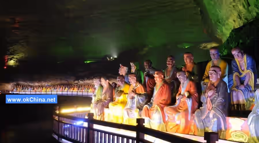
The Misty Cloud Cave is located on Guanxia Mountain in Sanquan Town, at an altitude of 1,040 meters. Every winter and spring, white mist drifts from the cave entrance, hence the name "Misty Cloud Cave." It formed during the Mesozoic Triassic period, approximately 180 million years ago. The cave is densely packed with stalactites and has a circular layout, over 800 meters long, with separate entrance and exit, entering from below and exiting above. The entrance is an artificially excavated arched tunnel, 2 meters high, 1.8 meters wide, and 27 meters long. Inside, it can be divided into nine scenic sections: Golden Buddha Hall, Crystal Palace, Thousand Pagoda Forest, Dragon-Subduing Cave, Elephant-Washing Pool, Nine-Pillar Colonnade, King Yu Holding the Jade Tablet, Immortal's Fields, and Golden Lion Seeing Guests Off. The exit is the original cave opening, sloping upward along the wall of the Golden Buddha Hall.
3.1.18 Dabao Cave
Dabao Cave is located on Dabao Mountain in Sanquan Town, at an altitude of 960 meters. The entrance is crescent-shaped, 2.5 meters high and 16 meters wide. The cave has two levels. The lower level is over 500 meters long, with a natural doorway dividing it into front, middle, and rear sections. Attractions include Stone Chamber Retreat, Goddess Nüwa Holding Up the Sky, Treasure-Guarding Divine Elephant, Underwater World, Buddha Preaching, Extraterrestrial Visitor, and Blushing Stone Monkey.
3.1.19 Old Dragon Cave
Following the Longyan River upstream for 2 kilometers from Sanquan, the Old Dragon Cave is on the south side. The entrance is over 30 meters high and nearly 20 meters wide. The cave has four levels. The first level has an underground river flowing out, with a hall on the west side covering over 400 square meters. The second level terrace has rimstone dams resembling "dragon fields." The third level serves only as a passageway. The fourth level has a small number of stalactites in various shapes. Winding downward leads back to the first level and directly to the entrance.
3.1.20 South Heaven Gate
The South Heaven Gate is located on the southern slope of Jinfo Mountain, at the front section of the "Qiaochang River Dam" canyon, at an altitude of over 1,600 meters. It is an open-air ridge formed by karst corrosion, towering at the top of a sheer cliff, shaped like a door frame, about 10 meters high and 7-8 meters wide.
3.1.21 Ecological Stone Forest
The Ecological Stone Forest is located about 1,000 meters south of Yaochi Dam, a stone forest covered by lush, verdant forest. The rocks protrude several or over ten meters above the ground, covered with thick moss. Trees and shrubs grow densely on top of and between the standing stones, with boxwood, azaleas, yew trees, etc., thriving. Within a 10-hectare area, it resembles a natural盆景 garden.
3.1.22 Three Springs
The Three Springs are located at the confluence of Longgu Stream and Longyan River. On the same cross-section of the Longyan River, 200 meters downstream, three springs are aligned. The cold spring is on the east bank, with a water temperature of about 15°C. The warm spring is in the middle of the river, with a constant temperature of 45°C, containing sulfides, carbonates, and other minerals, suitable for bathing. The hot spring was on the west bank, with a temperature reaching 60°C in earlier years, but later became blocked and dry. In 1996, a deep well was drilled at the hot spring site, yielding water above 40°C.
3.1.23 White Mist and Clear Haze
"White Mist and Clear Haze" is one of the "Eight Scenes of Nanchuan" from the Qing Dynasty. It refers to the scene at White Mist Ping below Xianglu Peak on the northern slope, where mist spreads after prolonged rain clears in spring and summer.
3.1.24 Red Rain on Baizhi
Baizhi Mountain has a high ridge named "Red Mountain," so called because the morning glow and evening sun often illuminate it red. The Nanchuan County Annals named this scene "Red Rain on Baizhi."
3.1.25 Golden Rooster Spreading Wings
Directly north of the sheer cliff on Zhongshan Terrace, there is a pass formed between two mountains called Lion's Mouth. A huge rock within has holes underneath. When the wind is strong and swift, the airflow撞击 the holes in the rock wall, creating a rustling sound resembling a rooster flapping its wings.
3.2 Cultural Landscapes
3.2.1 Longyan Fortress
Longyan Fortress is located on Mazui Rock in Sanquan Town, below which Liangfeng Ridge stands at 1,740 meters, serving as a strategic pass on the route between southern Chongqing and northern Guizhou. Built in the third year of the Baoyou era of the Southern Song Dynasty (1255 AD), about 60 meters of the fortress wall remain today. It was constructed encircling the rock top, with an inner height of 1.2 meters and an outer height of 2 meters, built with slab stones, featuring hidden passages and gun ports. About 30 meters below the stone arched gate, a well-preserved ancient cliff stele stands 3.5 meters high and 4.2 meters wide, with 257 characters, each 0.14 meters in diameter, carved in regular script intaglio with double-outline and磨棱 edges. The inscription records the historical facts of Southern Song generals Shi Qieju and Mao Shixiong of the Nanping Army building the fortress, resisting and defeating the Mongol army, and receiving commendation from Emperor Lizong of Song in the late Southern Song. In 2000, it was designated as a Chongqing Municipal Cultural Relics Protection Unit. The fortress gate is arched, built with条石. The gate opening is 1.8 meters high and 1.26 meters wide. The lintel, a long条石, bears the name "Panlong Zhai" carved in intaglio. Inside the gate, small characters are carved in two lines in intaglio on the stone arch: "Built in the Guichou year of the 4611th year of the Yellow Emperor's纪元," indicating reconstruction in the second year of the Republic of China (1913). Following the wall upward leads to an altitude of over 1,780 meters, where the terrain gradually becomes open and flat. Walking west about 1,000 meters, there are remains of semi-buried stone wall house foundations, divided into over ten rooms. Above is "Tianchi," locally called "Changpu Wan," which never dries up throughout the year and was a water storage area for stationed troops in former times.
3.2.2 Meiling Bridge
Meiling Bridge is located on the Longyan River, 100 meters downstream from the Sanquan springs. It was originally built to access the Chiang公馆 area. Initially, two stone-basket piers stood in the river, with fir wood beams, railings, and横铺 planks. Unable to withstand flood冲击, in the late 1950s, a new concrete deck and railings were built 200 meters downstream from the original bridge. Stone steps, over ten steps, were built on the left bank to access the bridge, while the right bank connects to a stone cliff. It is still called "Meiling Bridge."
3.2.3 Yu Ruolin Inscription
The Yu Ruolin Inscription is located at the entrance to the old market of Sanquan, within a small stone forest. A tall standing stone is inscribed with the three large characters "雨若林" (Yu Ruolin Forest). It was inscribed in 1944 (the 33rd year of the Republic of China) by Nanchuan native Liu Siying in memory of his younger brother Liu Yuruo. (Note: Liu Siying once served as Vice Minister of the National Government's Ministry of Economic Affairs, etc. Liu Yuruo was a professor at Central University, held a Master's degree from the U.S., and died in the line of duty while developing Jinfo Mountain.)
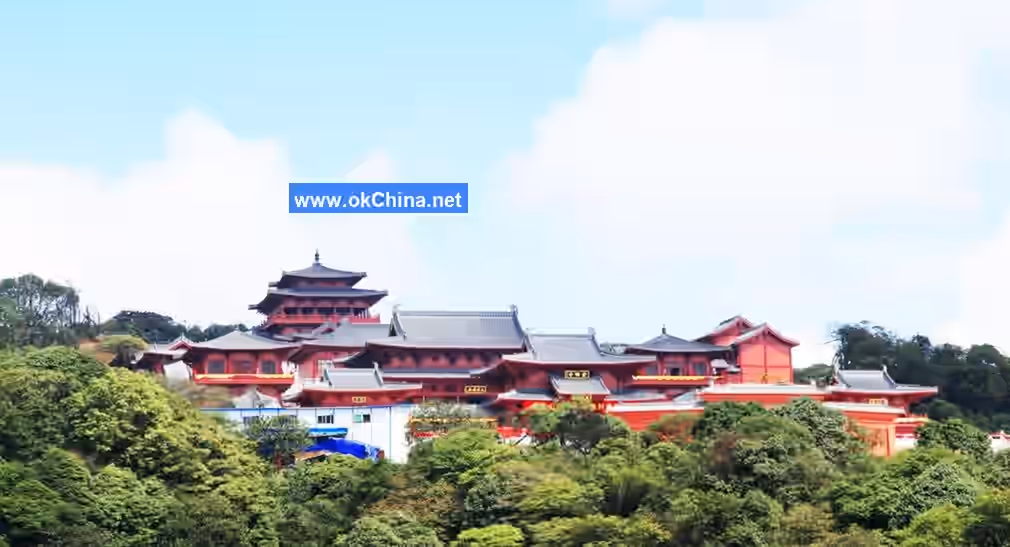
3.2.4 Jinfo Temple
The original site of Jinfo Temple was located southeast of Zhongshan Terrace on the mountaintop. Built in the Tang Dynasty, it was the foremost of the four famous temples on Jinfo Mountain. It was later relocated and rebuilt southwest of Fenghuang Temple. Construction began in 2010, and the renovated Jinfo Temple opened to visitors in 2014. It covers a total area of over 10,000 square meters, containing structures such as Bell and Drum Towers, Heavenly King Hall, Mahavira Hall, Seven Buddha Hall, and Scripture Depository, grand in scale and serene in atmosphere. Jinfo Temple is a famous Buddhist sanctuary in the Sichuan-Chongqing-Guizhou region. The current abbot is Master Daojian.
3.2.5 Fenghuang Temple
Fenghuang Temple is located below Qingliang Peak. According to the Nanchuan County Annals, it was first built in the Ming Dynasty. In 1996, the Jinfo Mountain Scenic Area Management Committee funded a简易 restoration of the main hall and invited two缅甸 jade Buddha statues for供奉. In 2010, Master Daojian raised about 3 million yuan for reconstruction. Today, Fenghuang Temple has surpassed its old scale, with majestic halls, bracket sets and upturned eaves, enclosed by walls,焕然一新. In front of the temple now stands a lush fir forest planted by monks during the Republic of China era. To the lower right front of the temple is an ancient well, with clear, icy-cold spring water seeping from its walls.
3.2.6 Iron Tile Temple
Iron Tile Temple is located in the western part of Jinfo Mountain. From Xiaoheba, passing Nima上山, crossing Lanni Dang, and proceeding about 1 kilometer leads to Iron Tile Temple. Built in the Ming Dynasty, it was named for its roof tiles全部 made of cast iron. It was destroyed again in the 1950s. Only ruins remain today, with several iron tiles collected by the Sichuan Museum.
3.2.7 Lotus Temple
Lotus Temple is located northeast of Jinfo Mountain, about 5 kilometers from Lion's Mouth. Built in the Ming Dynasty, the temple stood atop an isolated peak. It was destroyed during the Jiaqing era of the Qing Dynasty. Today, only a thriving forest of catalpa trees remains.
4. History and Culture
4.1 Historical Development
4.1.1 Origin of the Name
The name Jinfo Mountain (Golden Buddha Mountain) originates from the earliest Song Dynasty poem describing Nanchuan, Ballad of Gazing at Jinfo Mountain: "Gaze at Jinfo Mountain at dawn, gaze at Jinfo Mountain at dusk; How majestic is Jinfo Mountain, faintly visible amidst clouds and mist." Whenever the sky clears in late summer and autumn evenings, the setting sun's斜晖染 the layered cliffs golden and resplendent, resembling a golden Buddha radiating myriad rays of light, exceptionally spectacular and beautiful, hence the name.#### 4.1.2 Development History The early development of Jinfo Mountain began in the 27th year of the Republic of China (1938). The Central Relief Committee of the National Government formed the "Jinfo Mountain Resettlement and Reclamation Area Council," established a management office, and successively repaired the Jinfo Temple, Fenghuang Temple, and the mountain road from Sanquan to Longyan City, and constructed the Jinfo Cultural Relics Museum.
In 1990, the development of Dabao Cave and Yanyun Cave on Jinfo Mountain commenced.
In May 1993, the construction of the north slope road of Jinfo Mountain broke ground. The following year, a 18.3-kilometer-long gravel road on the north slope was opened to traffic. This road passed through the back gate of Hongquan Factory, crossed Daheba Primary School, Mozikou, and reached the Baiguolin Cableway.
In July 1999, the hardening of the north slope road and the cableway were completed and opened on the same day, marking the opening of the north slope tourist route.
In September 2006, Nanchuan County signed an overall development agreement for Jinfo Mountain with Chongqing Transportation and Tourism Investment Group. Chongqing Jiaolv Group obtained a 50-year development, operation, and management right. The development and construction included 12 scenic areas such as Tianxing Resort, Bitan Yougu Scenic Area, Qianniuping Scenic Area, and South Slope Scenic Area.
On May 1, 2009, the Bitan Yougu Scenic Area at the West Gate of Jinfo Mountain opened to tourists. In July of the same year, the West Slope Cableway of Jinfo Mountain was completed. By then, the major tourist circuit connecting the west, south, and north of Jinfo Mountain was fully operational.
On April 8, 2014, the "World Wild Ancient Azalea Park Scenic Area" in Jinfo Mountain, Nanchuan District, opened to tourists.
On February 8, 2018, the State Council approved the adjustment of the scope of the Chongqing Jinfo Mountain National Nature Reserve. The adjusted area, scope, and functional zoning of the reserve were to be announced by the Ministry of Environmental Protection.
In April 2018, the State Council approved the adjustment of the scope of the Chongqing Jinfo Mountain National Nature Reserve.
4.2 Legends and Stories
4.2.1 Legend One
It is said that during the Three Kingdoms period, Hua Tuo searched throughout famous mountains and great rivers to formulate the powerful painkiller "Mafo Powder" and finally found it at the Yaochi Dam on Jinfo Mountain. However, he was killed by the overly suspicious Cao Cao. Before his death, Hua Tuo told his son to change his name and flee into Jinfo Mountain to avoid harm, to pass on the medical knowledge he had learned, and to relieve the suffering of the common people. Hua Tuo's son came to Jinfo Mountain, where he remained silent, spending his days holding a medicinal hoe and carrying a medicinal basket, searching for herbs on perilous cliffs and peaks, appearing just like an ordinary herb gatherer. However, some of the herbs he dug up were planted in Yaochi Dam to let them multiply and flourish; some were cut into small pieces with a knife, ground into powder, and sprinkled over Yaochi Dam; and others were simply boiled in a pot into decoctions, which were then poured into Yaochi Dam. After three to five years, the entire Yaochi Dam became like a garden, a warehouse, and a preparation facility for medicinal herbs. Whenever the wind blew through this area, it turned into medicinal wind; whenever rain accumulated here, the water turned into medicinal liquid. His method of treating patients was to bring different patients to different spots in Yaochi Dam and have them sleep there for a few days. Once, a patient with intestinal parasites came. He had the patient lean against a tree in Yaochi Dam and lie there for three days and three nights. Steamed by the medicinal vapors from the surroundings, the patient expelled a pile of parasites and returned home easily. Thus, the name of the "Divine Doctor" spread.
4.2.2 Legend Two
In a certain dynasty, an imperial uncle, who was idle and averse to labor all day, contracted a strange disease covered with festering sores all over his body. He sought famous doctors from across the land, but none could cure him. Hearing rumors that there was a Divine Doctor on Jinfo Mountain who could cure all diseases but only treated the poor and was ineffective for officials and the wealthy, the imperial uncle disguised himself as a beggar and went to Jinfo Mountain. The Divine Doctor instructed this "beggar" to run nine laps around Yaochi Dam and roll on the ground nine times every day. To save his life, the imperial uncle had no choice but to comply. Running nine laps made him sweat profusely nine times, and rolling nine times allowed his sores to rub against the medicinal substances nine times. After nine days, the sores disappeared. Overjoyed, when an eight-man sedan chair came to escort him back to the capital, fearing that breaking the rules might cause a relapse, he refused to ride in the sedan or on horseback. Wearing his beggar's clothes all the way to the capital, he experienced the simple joys of family life among the common people and eventually chose to live as an ordinary citizen, remaining free from illness and pain for the rest of his life. Consequently, the fame of Yaochi Dam spread throughout the world.
Comments
Post a Comment