


Jiangbulake Scenic Area in Changji Hui Autonomous Prefecture
I. Introduction
Jiangbulake Scenic Area in Changji Hui Autonomous Prefecture, abbreviated as Jiangbulake Scenic Area, is located in Banjiegou Town, Qitai County, Changji Hui Autonomous Prefecture, Xinjiang Uygur Autonomous Region. Situated at the northern foot of the Tianshan Mountains and the southeastern edge of the Junggar Basin, it is 45 kilometers from Qitai County town and 195 kilometers from downtown Urumqi, covering a total area of 48 square kilometers. Jiangbulake Scenic Area represents a perfect combination of the typical vertical comprehensive landscape of mountain areas in the temperate arid zone and the unique mountain wheat field print. It is a continuation landscape of the Xinjiang Tianshan Mountains World Natural Heritage site and has been identified by the Chinese Academy of Sciences as one of the most completely preserved and earliest oasis cultures. The scenic area consists of five zones and eighteen attractions, including the Tianshan Strange Slope, Ten-Thousand-Mu Wheat Fields, Han Shule City, Wooden Plank Road, and Black Waterlogged Dam. The scenic area features massive and diverse resources, forming a distinctive, high-quality, and comprehensive international leisure and vacation tourism destination. It is underpinned by nine major cultures, including farming culture, frontier garrison culture, and nomadic culture, and offers main functions such as sightseeing and photography, leisure and vacation, scientific research and investigation, popular science education, hiking and adventure, and health and fitness. It is one of the core attractions of Xinjiang's "Tianshan · Thousand-Mile Golden Route."
II. Orientation and Layout
Location and Territory
Jiangbulake Scenic Area is located in Qitai County, Changji Hui Autonomous Prefecture, Xinjiang Uygur Autonomous Region, situated at the northern foot of the Tianshan Mountains and the southeastern edge of the Junggar Basin.
Topography and Landforms
Banjiegou Town, where Jiangbulake Scenic Area is located, features mountainous hills in the south and Gobi plains in the north.
Climate Characteristics
Banjiegou Town, where Jiangbulake Scenic Area is located, has a temperate continental arid to semi-arid climate characterized by four distinct seasons: hot summers, cold winters, and mild springs and autumns. The multi-year average temperature ranges from 2°C to 3°C. The average temperature in January is -15.8°C, with an extreme minimum of -35.5°C; the average temperature in July is 19.6°C, with an extreme maximum of 36.8°C. The average annual temperature range is 35.4°C, the average annual relative humidity is 60%, and the average annual frost-free period is 141 days. The average annual precipitation is 276 millimeters, and the average annual evaporation is 2,141 millimeters.
Seasonal Characteristics
Spring
As the snow melts, Jiangbulake becomes very quiet, allowing you to hear the dripping and rustling sounds of melting snow. Life quietly breaks through the earth's seal underground. Soon, "the color of grass seeps through the curtains," and "the grass appears green from afar but seems absent up close." There is a plant called "crow garlic" (pronounced "wa," fourth tone). It is a perennial herb with thick bulbs covered by purplish-red membranous scales and a milky-white interior, 2-4 centimeters in diameter. The lower root hairs are relatively hard and sparse. The leaves grow in clusters, emerging after flowering, and are linear and pinkish-green. It grows in shallow mountainous areas and is also distributed in some parts of Xinjiang. In spring, local children enjoy digging up crow garlic around houses and fields to eat. It tastes sweet and delicious, with a garlic and onion aroma.
Summer
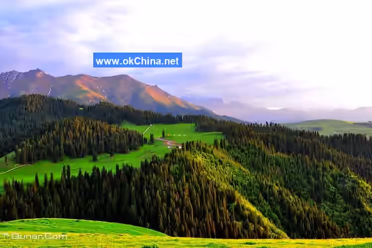
June and July each year are the seasons for escaping the heat and enjoying the summer. First-time visitors might mistakenly think they have arrived in Switzerland: knee-high flowers such as Dangshen flowers, fritillary flowers, and an unnamed small yellow flower cover the mountains and fields, growing naturally in layers in the grass as if planted by gods. They compete in beauty and fragrance, and the refreshing floral scent is intoxicating. In the distance, rolling mountains, layered peaks, and continuous ranges stretch endlessly, with verdant pines and cypresses reaching into the clouds. Snow-capped peaks, forest seas, and green grass and flowers form a beautiful landscape painting. Walking on the green, damp grass with cool breezes, breathing in the fresh air and the fragrance of flowers and plants, a feeling of spiritual purification by nature arises spontaneously. Further inside are the snow-capped mountains, with pristine snow that never melts year-round. Riding a horse, you can reach the foot of the snow-capped mountains, where the temperature drops sharply. Just moments ago, you were in shorts and a T-shirt, but now you need to put on thick cotton clothes. While the sun still shines on your body, a cloud passing overhead might bring a sudden downpour, leaving you soaked while still seeing the sun. After a while, the rain stops, and the mountain breeze has already dried your clothes without you noticing.
Autumn
On the endless rolling mountains, golden wheat waves undulate, with wheat fields and large bundles of wheat sheaves. In the golden fields, a few ancient trees are dotted here and there, accompanied by cattle, sheep, and houses. This scene rivals even the most famous Barbizon Manor in Europe or the villages painted by world-renowned oil painters like Van Gogh and Monet.
Winter
The continuous snow-covered mountains and the dark green black pine forests seem to be in a deep slumber. Only some strange claw prints can be seen in the snow, left by pheasants, hares, foxes, and even wolves. When you come from a polluted and smoggy city to this pristine snowy plateau, you will find everything here so clean and unpolluted. The air you breathe is so sweet. If you are thirsty, grab a handful of snow to eat; if you are hungry, grab another handful. It seems you are no longer thirsty or hungry. It is as if the snow at the foot of the snow-capped mountains is transformed from the holy water of immortality—the original meaning of "Jiangbulake" is "source of holy water." The snow from this area of snow-capped mountains melts, seeps underground, and flows downstream for hundreds of kilometers through underground channels. It is shared by humans and livestock, irrigates crops, and nourishes the entire population of downstream Qitai County. It is the sole source of groundwater for Qitai County. This is also the most typical pattern of human settlement—life thriving by the snow water from the snow-capped mountains.
III. Key Scenic Areas
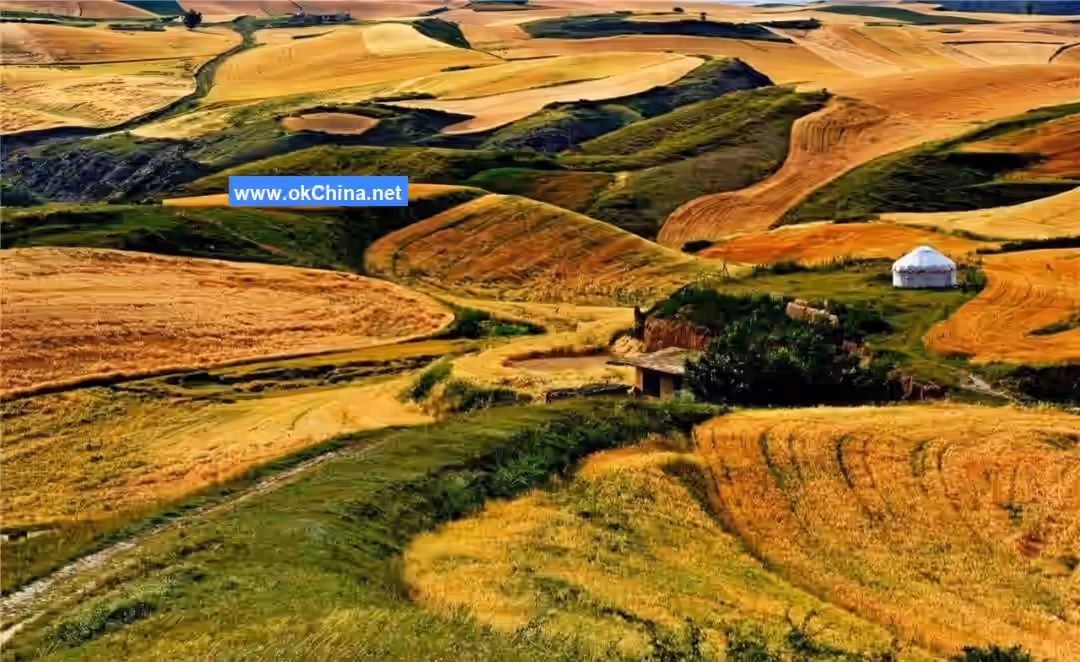
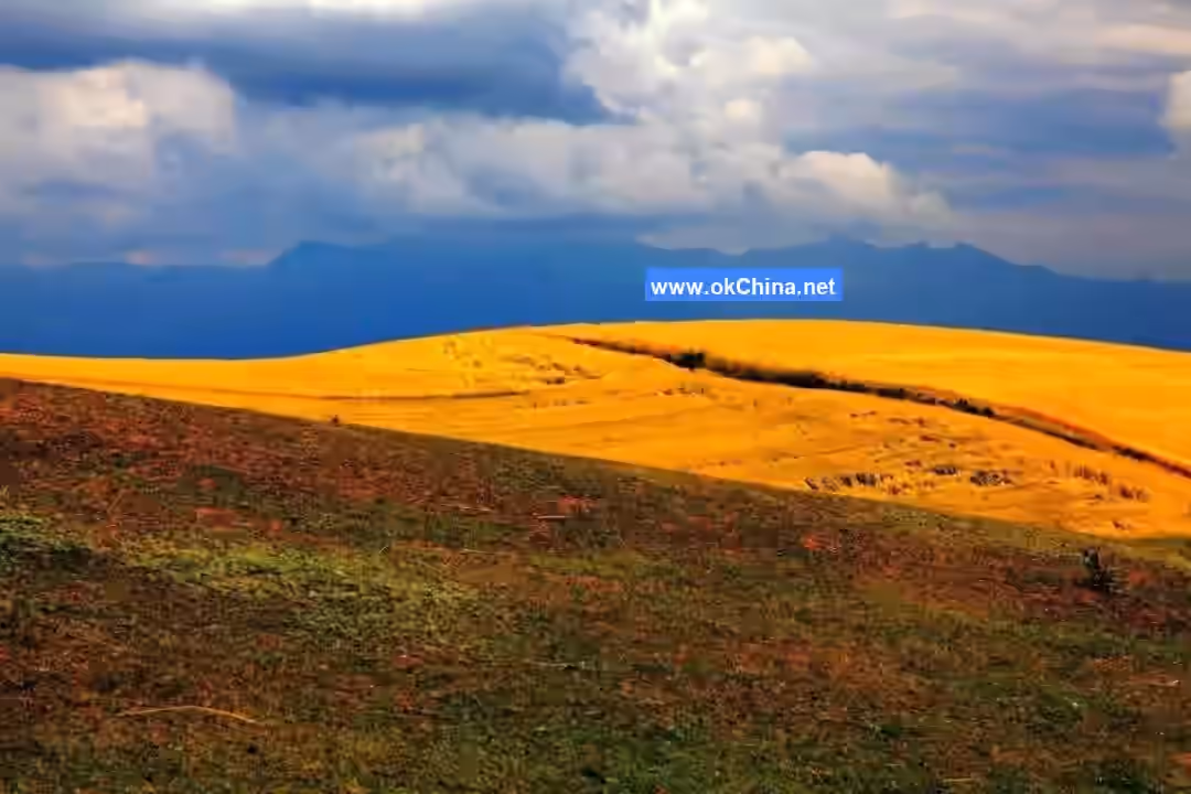
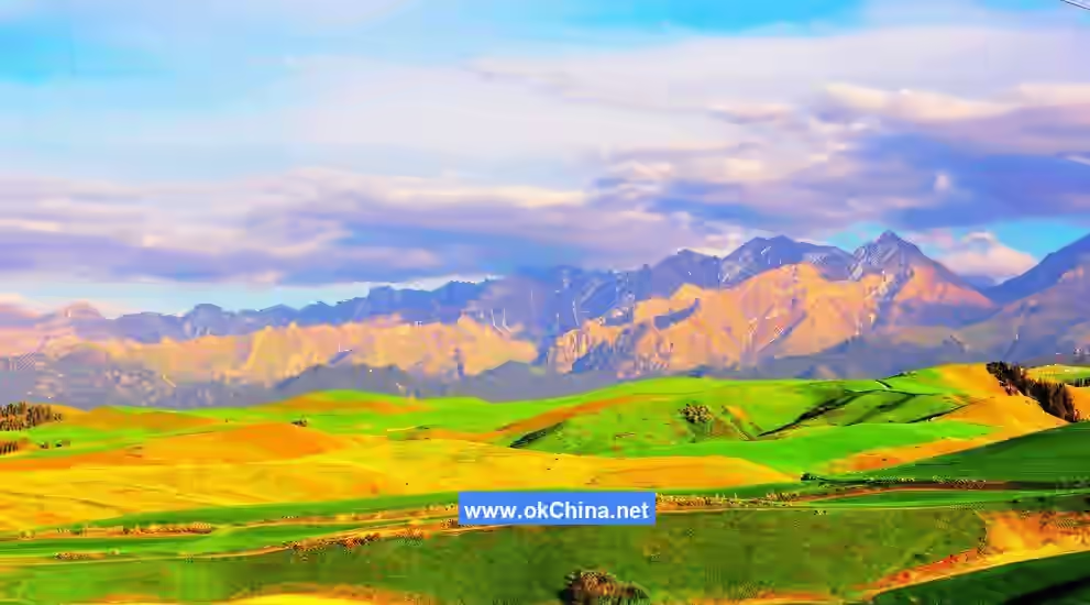
Tianshan Wheat Sea
Jiangbulake Scenic Area has a history of agricultural cultivation spanning over 2,000 years, dating back to the time of Emperor Yan of the Han Dynasty. The wheat fields in and around the scenic area cover an area of more than 200,000 mu, mainly distributed in the relatively flat foothill areas and low mountainous hills. The hills undulate with a height difference of 50–150 meters and a slope of about 20°, belonging to a typical temperature inversion zone climate with relatively abundant precipitation. The vast wheat fields undulate with the mountain terrain, with valleys interweaving and cutting through them. The wheat fields are naturally divided by gullies and freely partitioned according to the terrain, forming a picturesque three-dimensional wheat field landscape. The wheat field landscape changes with the seasons, presenting a land print art scene composed of patches of colors, acclaimed as China's most beautiful wheat fields. In 2015, the Qitai Dryland Farming System was successfully declared as a China Important Agricultural Heritage System and is currently applying for Globally Important Agricultural Heritage Systems status.
Ancient Shule City
Xinjiang has long been renowned for "Southern Loulan, Northern Shule," and the "Northern Shule" ruins are located within Jiangbulake Scenic Area. The Shule City ruins are the only relatively well-preserved Han Dynasty architectural site discovered in Xinjiang to date and have been approved by the State Council as a "National Key Cultural Relics Protection Unit." In 75 AD, Geng Gong, the Han Dynasty Commandant of the Northern Frontier, led 500 soldiers to resist tens of thousands of Xiongnu here for a year. When reinforcements arrived to escort them back to Yumen Pass, only 13 remained. This is the famous historical event known as "Thirteen Soldiers Return to Yumen Pass," a military miracle in ancient China where the few defeated the many and a glorious testament to frontier garrison culture.
Shichengzi Ruins
The Shichengzi Ruins are located in Magouliang Village, Banjiegou Town, Qitai County, in the hilly area at the foot of the Tianshan Mountains. The ancient city was built according to the terrain, higher in the north and lower in the south, with significant undulations. Its plan is rectangular, with the longest north-south distance about 460 meters, the widest east-west distance about 300 meters, and a total area of approximately 110,000 square meters. The northern and western city walls are relatively well-preserved, while the eastern and southern sides feature deep ravines. At the bottom of the ravines, the Magou River flows eastward, circling north through Heigou to Xinhu Liang. The Shichengzi ancient city ruins were first discovered in 1972, designated as an autonomous region-level cultural relics protection unit in 1999, and approved and announced by the State Council as a national key cultural relics protection unit in 2013. According to historical records and archaeological confirmation, the famous Battle of Shule City took place here. Shule City is a tangible trace of the Han Dynasty's strategic system, garrison strategy, military and administrative structure, and border defense in the Western Regions. It serves as historical evidence that "Xinjiang has been an inseparable part of the motherland since ancient times."
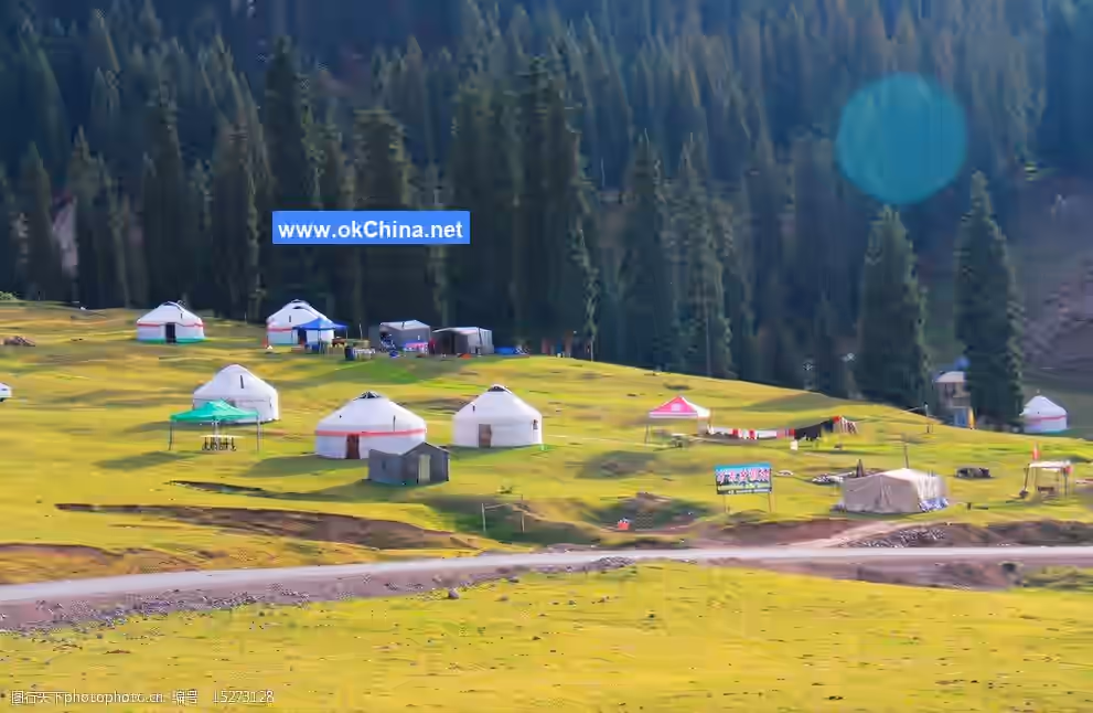
Magouliang Village
Magouliang Village is located on the gentle slopes at the foot of the Tianshan Mountains, surrounded by hills and scattered dwellings. It is named "Magouliang" because wild hemp grows everywhere. The village enjoys a cool and pleasant climate, fresh and pure air, and four distinct seasons. It is renowned as "a village nestled in the Tianshan Mountains, with beautiful scenery in all seasons." Here, one can "admire mountain flowers in spring, taste fruits in autumn, watch wheat waves in summer, and view snow in winter."
Tianshan Strange Slope
The Tianshan Strange Slope is 290 meters long and 80 meters wide, running north-south. It is locally known as the "Reverse Slope." Visually, the slope appears higher in the north and lower in the south, but vehicles here exhibit the phenomenon of "accelerating downhill and coasting uphill." When it rains or water is poured on the slope, the magical phenomena of "water flowing backward on cloudy or rainy days" and "water flowing uphill" occur. On May 17, 2005, after an on-site inspection by the Shanghai Great World Guinness Headquarters, it was awarded the "Great World Guinness Record" certificate, making the Tianshan Strange Slope the world's longest strange slope.
Flower Sea
Flower Sea is located on the hillside south of the Tianshan Strange Slope, covering an area of 666.67 hectares. It grows over 20 varieties of rare flowers and herbs, including many medicinal plants. Locals say, "Grab a handful of grass, and every blade is medicine," earning it the nickname "Valley of a Thousand Flowers and a Hundred Medicines." Every June, July, and August, hundreds of flowers bloom here in dazzling colors. Looking out, the sea of flowers seems to merge with the sky, resembling the colorful tapestries in Kazakh herders' yurts. A local herder's saying goes, "Flower Sea, the slopes are covered with flower carpets," praising the enchanting beauty of Flower Sea. Flower Sea is also a paradise for bees and a sacred place for beekeepers. It produces abundant honey, which is thick, sticky, sweet, and fresh.
Jiangbulake Grand CanyonJiangbulak Grand Canyon lies to the east of vast dry farmland and to the west of Daotiao Ridge, with an average elevation of 1,900 meters, stretching 15 kilometers in a winding path. Within the canyon, birch and pine forests intermingle densely, coexisting and growing together. Their varying shades create distinct layers in the sea of trees, presenting different scenery across the four seasons—spring, summer, autumn, and winter—and varying throughout the day at dawn, dusk, noon, and night. In the distance, rolling mountains and snow-capped peaks reflect verdant greenery, with the 4,000-meter-high Ma’an Mountain shrouded in mist, appearing both elegant and majestic. The wooden viewing walkway follows the mountain terrain, winding and steep, stretching into the clouds from afar like a staircase to the sky, hence its name "Stairway to Heaven," also known as the "Cloud Ladder."
Broken Bridge
There are two explanations for the name "Broken Bridge." One suggests that there was originally a bridge here that was frequently washed away by water, earning it the name "Broken Bridge." The other explanation is that to facilitate the passage of Kazakh herders and their livestock during seasonal migrations, a gap was intentionally left in the otherwise continuous wooden walkway built over the grassland, giving it the name "Broken Bridge." From here, visitors can directly step onto the wooden walkway to enjoy the scenery along the way. Looking up, one can admire the majestic snow-capped mountains and towering pine forests; looking down, one can view the blooming mountain flowers and grazing livestock on the grassland, along with the Tianshan wheat fields, aerial grasslands, and snow-capped peaks amidst the sea of trees.
Sandao Bianzi
"Bian" refers to bends or slopes. Here, due to the high mountains, steep slopes, and sharp turns, the mountain road resembles a rope connecting three bends, which is why local herders call it "Sandao Bian," also carrying the meaning of safe passage. The scenery of Sandao Bian is beautiful and majestic, with verdant pines standing tall nearby, providing dense shade, while distant peaks interlace, gleaming with silver light, creating a graceful and diverse natural landscape.
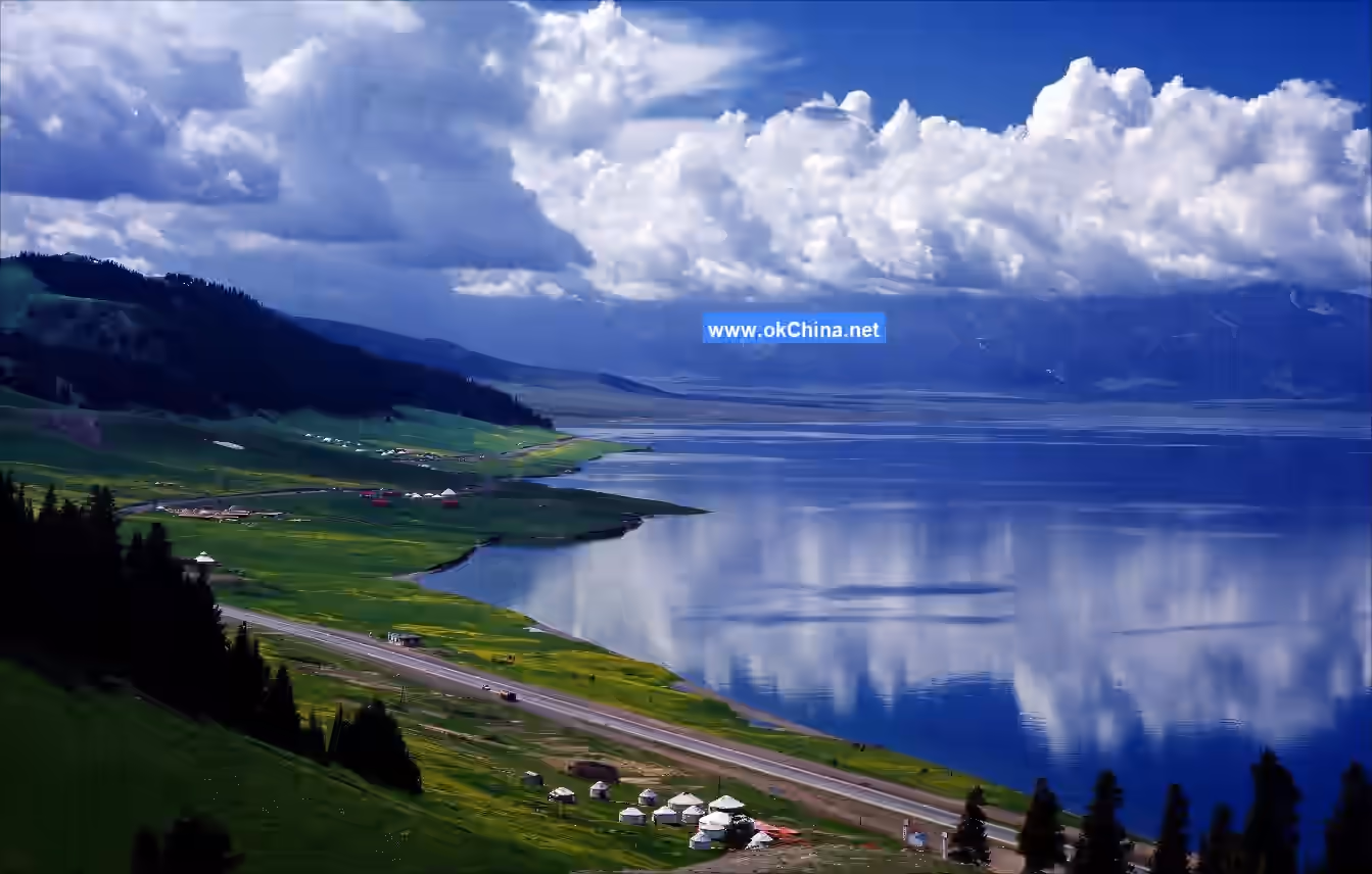
Xinhu River
Xinhu River is the main river flowing through the scenic area, running ceaselessly throughout the four seasons. Its upper reaches are home to Kazakh yurts, log cabins, and pastures, while its lower reaches converge into Shengxian Lake (Xinhu River Reservoir), irrigating numerous fields below the mountains and nurturing the local people.
Ancient City Ruins—Han Shule Ancient City
The Ancient City Ruins—Han Shule Ancient City is located in the southeastern part of the Xinjiang Jiangbulak National Forest Park. Locally known as Shichengzi, it is a Han Dynasty-style ancient city ruin in Xinjiang, historically linked to General Geng Gong’s resistance against the Xiongnu during the Han Dynasty.
Geng Gong Platform
Geng Gong Platform is located in the southeastern part of the Xinjiang Jiangbulak National Forest Park. It is said to be the watchtower where the famous Eastern Han general Geng Gong guarded Shule City and monitored enemy movements.
Shule City Canyon
Shule City Canyon is located in the southeastern part of the Xinjiang Jiangbulak National Forest Park. It features 13 waterfalls of varying sizes, along with scenic spots such as Broken Water Gully, Cliff Walls, and Echo Slope.
Tianshan Strange Slope
Tianshan Strange Slope is located in the southern part of the Xinjiang Jiangbulak National Forest Park, stretching 290 meters in length. After an on-site inspection by the Shanghai Great World Guinness Headquarters, it was certified as the "World’s First Strange Slope."
Recreational Facilities
Strange Slope Cycling
On the Guinness World Record–holding "Tianshan Strange Slope," experience the unique cycling sensation of "effortless uphill and strenuous downhill."
Tubular Rail Slide
Amidst the blooming sea of mountain flowers, ride on the longest tubular rail slide in northwest China, descending at a maximum speed of 40 km/h. Immerse yourself in the thrill, excitement, and the romantic scenery of "flowers blooming on the slopes while people fly among them."
Go-Karting
Gather a few friends and drive go-karts on a track free of traffic lights and obstacles, filled only with joy. Engage in a thrilling "contest" of speed and passion—an experience you won’t want to miss.
IV. Cultural Resources (Including Myths, Poems, and Notable Figures)
Local Snacks
- Pilaf: Pilaf is one of Xinjiang’s signature dishes, known for its delicious taste and rich nutrition.
- Lamb Skewers: Lamb skewers are a classic Xinjiang barbecue delicacy, best enjoyed with fresh vegetables and spices for an exceptional flavor.
- Roast Whole Lamb: Roast whole lamb is a traditional Xinjiang dish, made from a whole lamb roasted to tender and fragrant perfection.
- Mixed Noodles: Mixed noodles are a traditional Xinjiang noodle dish, served with fresh vegetables and savory sauces for a delicious taste.
Flora and Fauna Resources
Flora Resources
The flora in the Xinjiang Jiangbulak National Forest Park is mainly distributed in the forest-steppe zone at elevations of 1,800 to 3,000 meters. Plant species include spruce, Eurasian juniper, Korean pine, white birch, forget-me-nots, mint, motherwort, codonopsis, geraniums, anemones, morning glories, white clover, dandelions, cinquefoils, Xinjiang wormwood, tulips, Xinjiang peonies, fritillaries, astragalus, Xinjiang saussurea, bupleurum, roses, honeysuckle, rock jasmine, meadow rue, and snow lotus.
Fauna Resources
The fauna in the Xinjiang Jiangbulak National Forest Park includes argali, red deer, snowcocks, hares, squirrels, moles, marmots, eagles, crows, magpies, woodpeckers, tits, snakes, lizards, locusts, meadow browns, parnassians, bees, and more.
Awards and Honors
- In 2012, Jiangbulak Scenic Area was certified as a National AAAA-level Tourist Attraction.
- On September 15, 2023, Jiangbulak Scenic Area was selected as a second-batch autonomous region-level civilized tourism demonstration unit.
- On July 6, 2022, Jiangbulak Scenic Area was certified as a National AAAAA-level Tourist Attraction.
Comments
Post a Comment