Hulunbuir Grassland And Moergai River Scenic Area

Location Map

Map of Hulunbuir Grassland And Moergai River Scenic Area

Ticket Price

Ticket Information

The grassland itself does not require an entrance ticket, but some of the smaller scenic spots and attractions within it do charge admission. Whether to purchase tickets for these sites depends on your personal itinerary and preferences.

Opening Hours

Opening Hours

Open 24 hours a day, all year round.

Recommended Duration

Suggested Duration of Visit

It is recommended to spend a minimum of 2 days and up to around 10 days.

Best Time to Visit

Best Time to Visit

Generally, June to September is recommended. During this period, the grasslands are lush and green, flowers bloom across the fields, creating a breathtakingly beautiful scene. The temperature is also most comfortable at this time. Other seasons are also suitable for visiting.

Spring (March to May): Visiting Hulunbuir in spring offers a view of everything in its newborn state. The green grasslands are covered with blooming azaleas, creating a vibrant and stunning landscape.

Summer (June to August): Summer in Hulunbuir provides an escape from the stifling heat, making it a natural summer retreat. The bright and captivating sky, layered white clouds, vast green grasslands, and scattered flocks of sheep showcase the true vastness of Hulunbuir. However, visitors should be prepared for mosquito bites and are advised to bring insect repellent.

Autumn (September to November): The colorful primeval forests are a distinctive feature of autumn in Hulunbuir. You can also visit the Greater Khingan Mountains forest area to see towering trees reaching for the sky, experience the rolling mountain paths, and immerse yourself in the unique atmosphere of autumn.

Winter (December to February of the following year): While snowy landscapes can be experienced in many places, Hulunbuir in winter offers a vast, uninterrupted expanse of silver-white scenery, presenting a pristine and enchanting beauty.

Tips:

The fire prevention period is from March 15 to June 15 each year. During this time, visitors to most areas of Hulunbuir City must obtain a "Forest and Grassland Fire Prevention Permit," commonly referred to as a fire prevention permit.

Hulunbuir experiences significant temperature differences between day and night. Regardless of the season, it is essential to prepare for cold weather and stay warm.

Official Phone

Scenic Area Telephone

0470-8217020

Transportation

Transportation Recommendations

Self-Driving Tour (Recommended)

If you have the means, opting for a self-driving tour in Hulunbuir offers exceptional freedom. Along the way, you can stop anytime and anywhere to get up close with the stunning scenery. However, due to the vast expanse of Hulunbuir, it’s essential to plan your route in advance and be very familiar with local road conditions. It’s also highly advisable to have a local friend accompany you as a guide. This ensures a smooth and enjoyable journey, making your entire self-driving trip a success!

Chartered Car Tour (Highly Recommended)

Compared to a self-driving tour, a chartered car tour comes with a driver who is more familiar with local road conditions and the most beautiful scenic spots along the way, allowing you to discover unexpected delights during your travels. Additionally, a reputable travel agency specializing in customized tours can tailor a personal itinerary based on your specific needs. This saves you the effort and stress of designing a comprehensive route yourself, as well as worrying about road conditions, vehicle inspections, and other logistical details.

Classical Route

Route Recommendations

Short Route One: Hulunbuir Grassland & Manzhouli Port 2-Day Tour

Itinerary

  • Day 1: Hailar → Hulun Lake (180 km) → National Gate Scenic Area → Manzhouli (200 km)
  • Day 2: Manzhouli → Hulunbuir Grassland Scenic Area → Hailar (Total 200 km)

Highlights

  • Hulunbuir Grassland: One of the world's three major grasslands, featuring vast pastures and borderland scenery.
  • Hulun Lake: The largest lake in Inner Mongolia, a summer retreat and a paradise for photographers.
  • Manzhouli: A unique blend of Chinese and Western cultures, brimming with Russian charm.

Tips

  • Best Time to Visit: June to September each year, with the grassland pastures at their lushest from July to August.
  • Peak Tourist Season: July to August, characterized by limited accommodation and higher prices. It is advisable to book rooms in advance or join a tour group.

Short Route Two: Deep Grassland Reindeer Encounter & Ethnic Homestay Experience 5-Day Tour

Itinerary

  • Day 1: Hailar → Manzhouli (200 km, 3-hour drive. Experience sheep slaughtering at a herder's home, visit Matryoshka Square)
  • Day 2: Manzhouli → Genhe (240 km, 3.5-hour drive. View the National Gate from a distance, visit Budongxia Hunter Village)
  • Day 3: Genhe → Shiwei (220 km, 3-hour drive. Explore Ergun Wetland, visit Shiwei Russian Ethnic Township)
  • Day 4: Shiwei → Ergun (170 km, 2.5-hour drive. Visit Birch Forest, hands-on bread making experience)
  • Day 5: Ergun → Hailar (136 km, 2-hour drive)

Highlights

  • Manzhouli: A city with frontier Russian charm, featuring attractions like Matryoshka Square.
  • Heishantou: The best spot to watch the sunset.
  • Genhe Wetland: Majestic river valley scenery, distant views of the National Gate, and an experience of Budongxia Hunter Village culture.
  • Shiwei: A border town where you can experience exotic Russian风情 without crossing the border.

Reasons for Recommendation

  • Focus on northern scenic views, complemented by southern cultural experiences, offering rich and well-developed forest and wetland resources.

Tips

  • Best Season: Autumn, to enjoy the dreamy autumn colors along the way.
  • Attractions are far apart, so a chartered car or self-drive tour is recommended.

Long Route One: Hulunbuir Panoramic Experience 6-Day Tour

Itinerary

  • Day 1: Hailar → Moirigele (36 km, 50-minute drive. Moirigele Grassland Scenic Area)
  • Day 2: Moirigele → 7th Card (240 km, 2.5-hour drive), 8th Card (40 km, 50-minute drive), Enhe (50 km, 1-hour drive) (Travel along the Card Route, visit Enhe Town of Sino-Russian descendants)
  • Day 3: Enhe → Shiwei (60 km, 1-hour drive) → Moerdaoga Park (110 km, approx. 1.5-hour drive) → Moerdaoga (25 km, 20-minute drive) (Explore the charming town of Shiwei, visit Moerdaoga Park)
  • Day 4: Moerdaoga → Genhe (170 km, 3-hour drive. Visit Aoluguya Reindeer Park, the starting point of Santa Claus)
  • Day 5: Genhe → Manzhouli (240 km, 3.5-hour drive. Explore the border city Manzhouli, visit Matryoshka Square)
  • Day 6: Manzhouli → Hailar (200 km, 3-hour drive. Visit Erka Wetland, Donghu Scenic Area)

Highlights

  • Moirigele Grassland: Take in the panoramic view of the winding Moirigele River, accompanied by seas of flowers along the way.
  • Enhe Town: Stroll along field paths and experience a slow-paced lifestyle.
  • Shiwei Town: One of the Top Ten Charming Towns, offering views of the Greater Khingan Range forest scenery.
  • Genhe Wetland: Asia's largest wetland, showcasing spectacular wetland landscapes.
  • Manzhouli: Experience Mongolian folk customs, visit Hulun Lake, the National Gate, and Matryoshka Square.

Reasons for Recommendation

  • Northern and Southern Loop: Ideal for those with limited time, featuring beautiful and diverse northern natural scenery and the Russian charm of border towns.

Tips

  • Visit in Autumn: To enjoy scenery rarely seen in inland and coastal areas.

Long Route Two: Hulunbuir 10-Day In-Depth Experience Tour

Itinerary

  • Day 1: Hailar → Jinzhanghan → Moirigele → Moirigele Grassland Scenic Area (36 km, 50-minute drive)
  • Day 2: Hulunbuir Grassland → Enhe (210 km, 2-hour drive)
  • Day 3: Enhe → Moerdaoga (170 km, approx. 2-hour drive) → Moerdaoga Town (25 km, 20-minute drive)
  • Day 4: Moerdaoga → Taiping Village (60 km, 1-hour drive) → Eagle's Beak (25 km, 15-minute drive) → Linjiang (9 km, 10-minute drive)
  • Day 5: Linjiang → Shiwei (15 km, 10-minute drive) → 9th Card (20 km, 15-minute drive) → 7th Card (100 km, 2-hour drive) → 5th Card (40 km, 30-minute drive) → Heishantou (38 km, 30-minute drive)
  • Day 6: Heishantou → Manzhouli (200 km, 2-hour drive)
  • Day 7: Manzhouli → Hulun Lake (40 km, 50-minute drive) → Manzhouli
  • Day 8: Manzhouli → Arxan (410 km, 6-hour drive)
  • Day 9: Arxan → Arxan National Forest Park (100 km, 2.5-hour drive)
  • Day 10: Arxan → Hailar (300 km, 5-hour drive)

Highlights

  • Jinzhanghan: Admire the winding "Nine Turns and Eighteen Bends" of the Moirigele River.
  • Reindeer: Get up close with the sacred reindeer of the Greater Khingan Range.
  • Linjiang: Enjoy the slow-paced rural life of the "Shangri-La" village, Linjiang.
  • Shiwei: Experience unique Russian ethnic customs and enjoy the beauty of the Ergun River.
  • Birch Forest: Stroll through graceful stretches of birch trees.
  • Genhe Wetland: Gaze at the Horse Hoof Island, the "Heart of Asia" blending with the sky.
  • Heishantou: Witness the most beautiful sunset.
  • Hulun Lake: The largest lake in northern China, where you can immerse yourself in its sparkling waters.
  • Arxan: Volcanic rock landscapes and the unique Arxan Tianchi (Heavenly Lake) group.

Reasons for Recommendation

  • In-depth Grand Loop: A comprehensive tour that deeply explores the major scenic spots along both the northern and southern loops of Hulunbuir.

Tips

  • Winter Snow Viewing: Visit Hulunbuir in December to enjoy snowscapes, watch the Winter Nadam Festival, and have close encounters with the reindeer at Aoluguya in Genhe, the "Cold Pole".

Important Notes

Inner Mongolia Travel Precautions

  1. Clothing Preparation: Inner Mongolia has an average altitude of about 1,000 meters with significant temperature differences between morning and evening. Bring thick clothing, long pants, and sports shoes, along with emergency items like sunscreen and gastrointestinal medicine.

  2. Trip Booking: The peak tourist season in Inner Mongolia is short and concentrated. To visit the grasslands at their most beautiful, make reservations before traveling to any destination.

  3. Baidu Offline Maps:

    • Road signs along the way are clear, and most roads have only one main route.
    • Counting the road signs on the main route (marked with kilometer numbers) can help confirm if you are on the main road.
    • Areas such as near Heishantou, the Jiuka/Qika sections, the route from Genhe to Mangui, and the section from Jinhe Town to Moerdaoga have little to no mobile signal. Download Baidu offline maps in advance and start navigation while still in areas with signal.
  4. Car Rental:

    • Renting a car on weekends is more expensive, so try to avoid it if possible.
    • It is recommended to purchase the 50 yuan/day no-deductible insurance, as many roads ahead are narrow, and vehicles can easily be scratched by branches extending from the roadside.
  5. Refueling: Every town has gas stations, but they are rarely seen along the way. Ensure you have enough fuel to reach the next town.

  6. Driving at Night:

    • Grassland roads are mostly two-way single lanes, narrow, and often winding.
    • At night, there are many large trucks or hay transport vehicles, which are wide. When passing these vehicles, their headlights can be blinding and make it difficult to see, posing a significant danger.
    • Fog on the grasslands at night can be frightening, appearing in patches. When fog rolls in, visibility can drop to less than 3 meters ahead.
  7. Respecting Customs: The Mongolian people are warm and hospitable. Please listen carefully to the guide's explanations and respect the customs and traditions of ethnic minorities to avoid causing trouble.

  8. Horseback Riding Safety:

    • Do not stand behind or to the right of a horse.
    • Do not play or fight on horseback, and never whip your own or someone else's horse.
    • Always follow the instructions and arrangements of the horse team staff.
  9. Exploring Side Roads: There are many side roads along the way with visible vehicle tracks, which may lead to undiscovered scenic areas, especially on the route from Genhe to Mangui. If you have enough people and time, driving into the primitive forest can lead to unexpected and breathtaking discoveries.

Important Child Sites

Attraction Recommendations

  1. Morigele River
  • Known as the "Number One Meandering River in the World," it is the most famous scenic pasture on the Hulunbuir Grassland.
  • Filming location for numerous TV shows and movies such as "The Ghouls" and "Where Are We Going, Dad?"
  • Features the spectacular sight of nine bends and eighteen curves across the grassland, with endless vistas that offer an immersive and breathtaking experience.
  1. Golden Horde
  • Located in the heart of the Hulunbuir Grassland, this area has historically been a cradle for many nomadic tribes.
  • Once a camp for Genghis Khan’s troops, visitors can experience the rich culture of nomadic tribes here.
  • Offers exciting performances such as horse lassoing and taming, Mongolian wrestling, wrestling tournaments, Oboo worship ceremonies, and Shamanistic cultural shows.
  • Join lively bonfire parties and savor authentic Mongolian cuisine like roasted whole lamb and fermented mare’s milk.
  1. Chenbar Grassland
  • Renowned as the "Number One Grassland in the World," it represents the essence of the Hulunbuir Grassland.
  • A livestock production base, it once served as Genghis Khan’s arsenal, granary, and training ground.
  • With blue skies, white clouds, and herds of cattle and horses, the vast and boundless grassland offers a beauty beyond words.
  1. Ergun Wetland
  • Also known as Genhe Wetland, it is located in the northwestern suburbs of Labudalin Town, Ergun City, Hulunbuir, about 3 kilometers from the city center.
  • Named after the Genhe River, a tributary of the Ergun River, it forms a magnificent and picturesque river wetland landscape.
  1. Aoluguya Reindeer
  • Located deep in the Greater Khingan Mountains, these reindeer are commonly known as "four-unlike" or "horned deer."
  • Gentle and approachable, visitors can feed, interact with, and take photos with them, as if stepping into a fairy-tale world.
  • Enjoy intimate moments with these enchanting creatures in the reindeer tribe.
  1. Moon Lake
  • A beautiful lake named for its crescent-moon shape.
  • The lakeshore offers expansive views and stunning scenery, making it an unmissable highlight of Linjiang Village.
  1. Sunset at Heishantou
  • Heishantou Lieff Wetland Resort is located in Heishantou Town, Ergun City, Hulunbuir.
  • It is 10 kilometers from Heishantou Port and 40 kilometers from downtown Ergun.
  • Features a unique 1.5-kilometer wetland area, offering views of the vast grassland, distinctive forests, and river landscapes.
  1. Wheat Field Flower Sea
  • The endless grassland provides a sense of liberation for the soul.
  • Admire the beautiful sea of flowers in the wheat fields and experience the boundless charm of nature.
  • No matter where you choose, you can capture stunning photographs.
  1. Hulun Lake
    Hulun Lake is a magnificent highlight of the Hulunbuir Grassland. Standing by the lake, the horizon seems endless. It’s common to encounter sudden weather changes here—clear skies can quickly turn stormy, bringing rain while the sun still shines in the west, creating a rare "sun shower."

  2. Majestic National Gate

  • The Manzhouli National Gate Scenic Area is located 9 kilometers west of downtown Manzhouli, on the Chinese side of the Sino-Russian border.
  • The earliest national gate was a green trestle bridge built in the late 1960s, spanning railway tracks of different gauges used by China and the Soviet Union.
  • The bridge’s railings were embedded with wooden planks, and a prominent slogan, "Workers of the world, unite!" was inscribed on the side facing the Soviet Union.
  • Iron ladders were installed on both sides of the inspection bridge, allowing visitors to climb up and look down into passing vehicles.
  • From the top, the surrounding scenery is fully visible, symbolically referred to as the "National Gate."

Official Website

Scenic Area Official Website

http://www.xn----s46an1j5lgqw6bb5qg5fda529vjgg61osye8u3gchbh07f.com/

Brief History

Hulunbuir Grassland · Morgele River Scenic Area

I. Introduction (General Overview, including bilingual name, location, and significance)

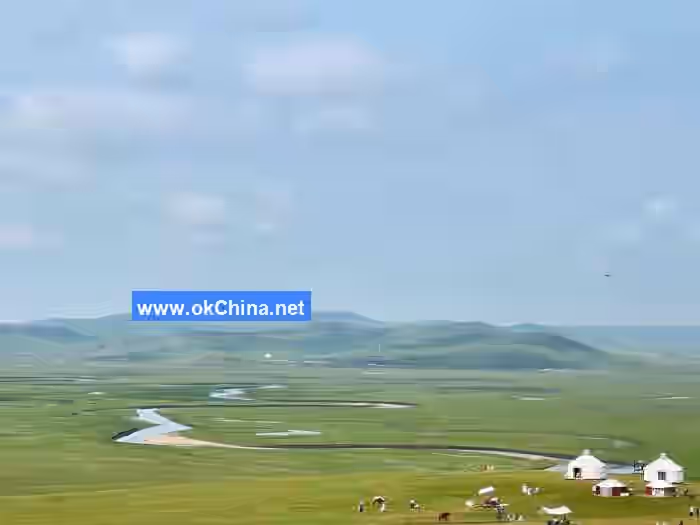
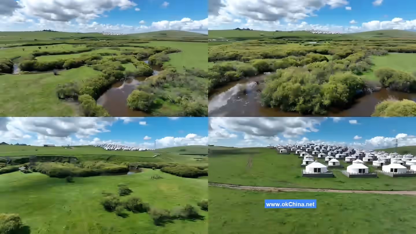
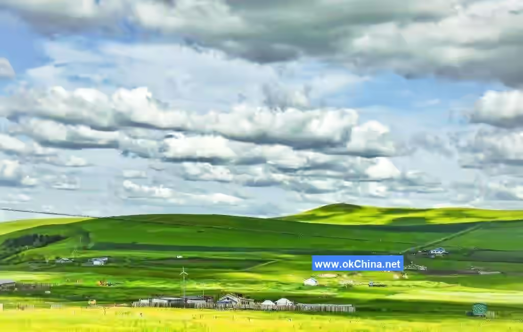
The Hulunbuir Grassland · Morgele River Scenic Area, abbreviated as the Morgele River Scenic Area, is located in Chen Barag Banner, Hulunbuir City, Inner Mongolia Autonomous Region, with a total area of 51.42 square kilometers. The Morgele River Scenic Area is situated in the heart of the Hulunbuir Grassland, representing the most important, typical, and representative meadow grassland area of Hulunbuir. With a development focus on "ecological grassland, grassland ecology," the scenic area showcases the evolution and development of ecological civilization concepts within nomadic culture over millennia, the customs and traditions of various ethnic groups rooted deep in the Hulunbuir Grassland, and the historical context of the integration and development of grassland culture with Central Plains culture. The scenic area currently features two visitor centers, three viewing platforms, two scenic spots, two camp hotels, tea break facilities, and other amenities. On February 6, 2024, the Hulunbuir Grassland · Morgele River Scenic Area met the standards for a National 5A-level Tourist Attraction and was officially designated as such.

Hulunbuir Grassland

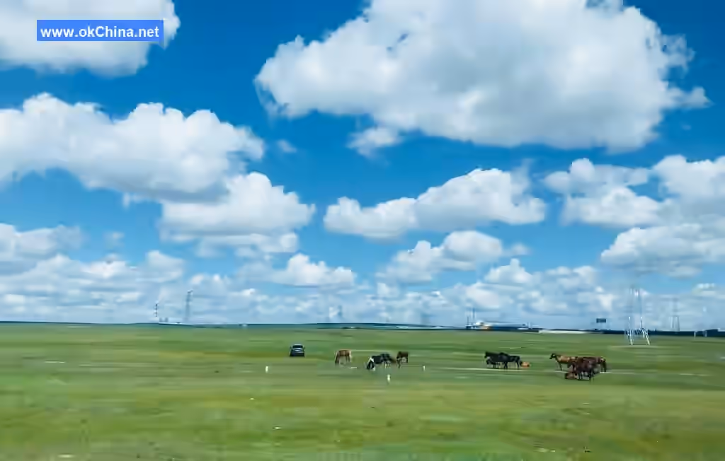
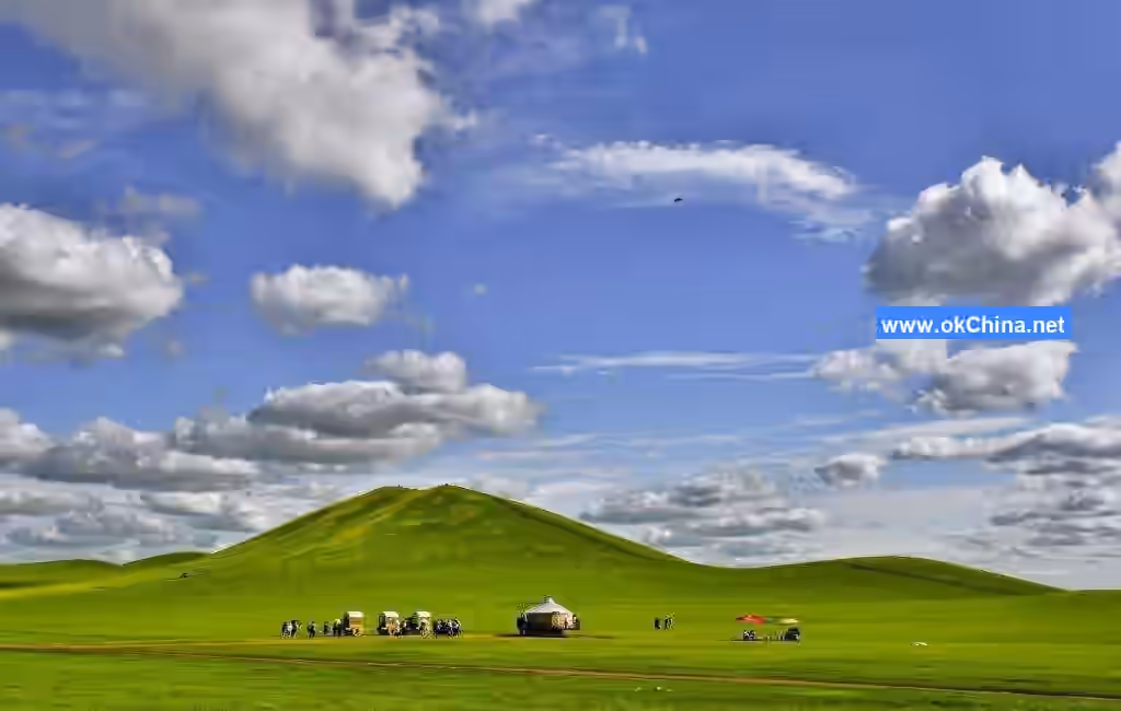
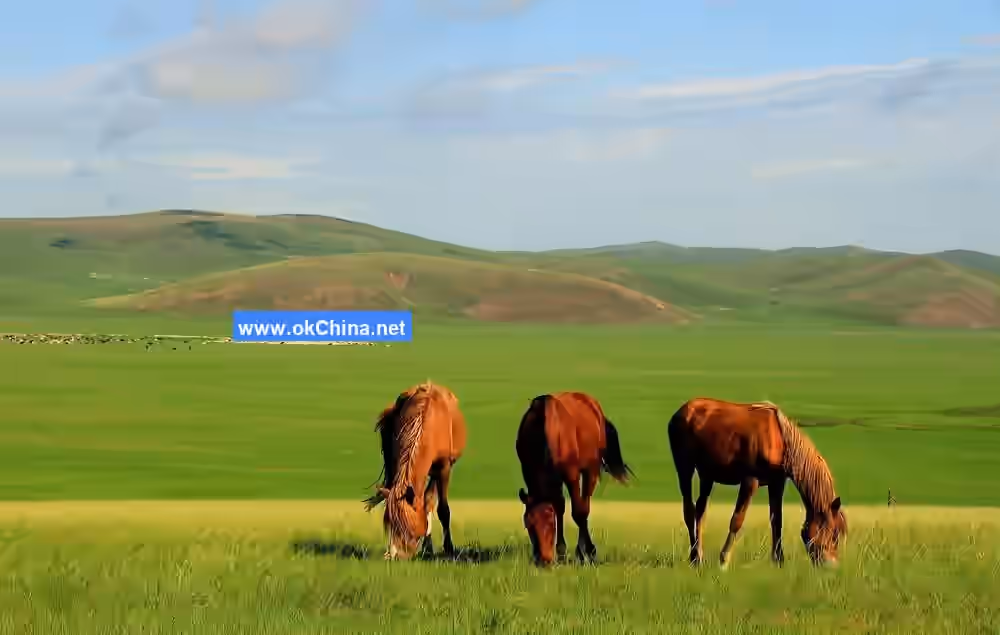
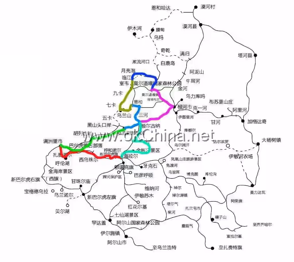
The Hulunbuir Grassland is located in the northeastern part of the Inner Mongolia Autonomous Region, on the Hulunbuir Plateau west of the Greater Khingan Mountains. It is named after Hulun Lake and Buir Lake. The terrain slopes from high in the east to low in the west, with elevations ranging between 650 and 700 meters. It spans approximately 350 kilometers from east to west and 300 kilometers from north to south, covering a total area of about 113,000 square kilometers (149 million mu), of which 8.3333 million hectares are usable pastureland. Hulunbuir Grassland is a world-renowned natural pasture, one of the world's four major grasslands, acclaimed as the best grassland in the world, and one of China's top twenty tourist attractions. Hulunbuir Grassland is the birthplace of numerous ancient civilizations and nomadic peoples, including the Donghu, Xiongnu, Xianbei, Shiwei, Uyghur, Turkic, Khitan, Jurchen, and Mongol ethnic groups. It is hailed by historians as the "Cradle of Northern Chinese Nomadic Peoples" and holds a significant place in world history.

Morgele River

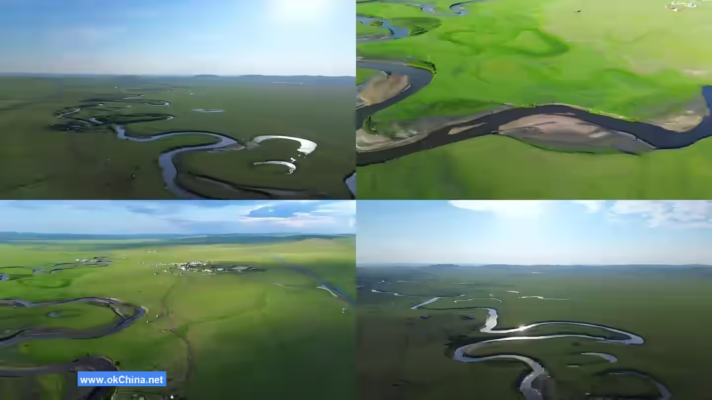
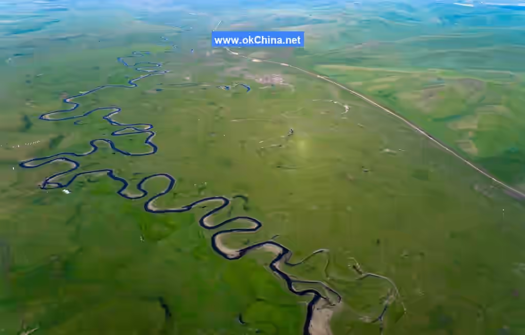
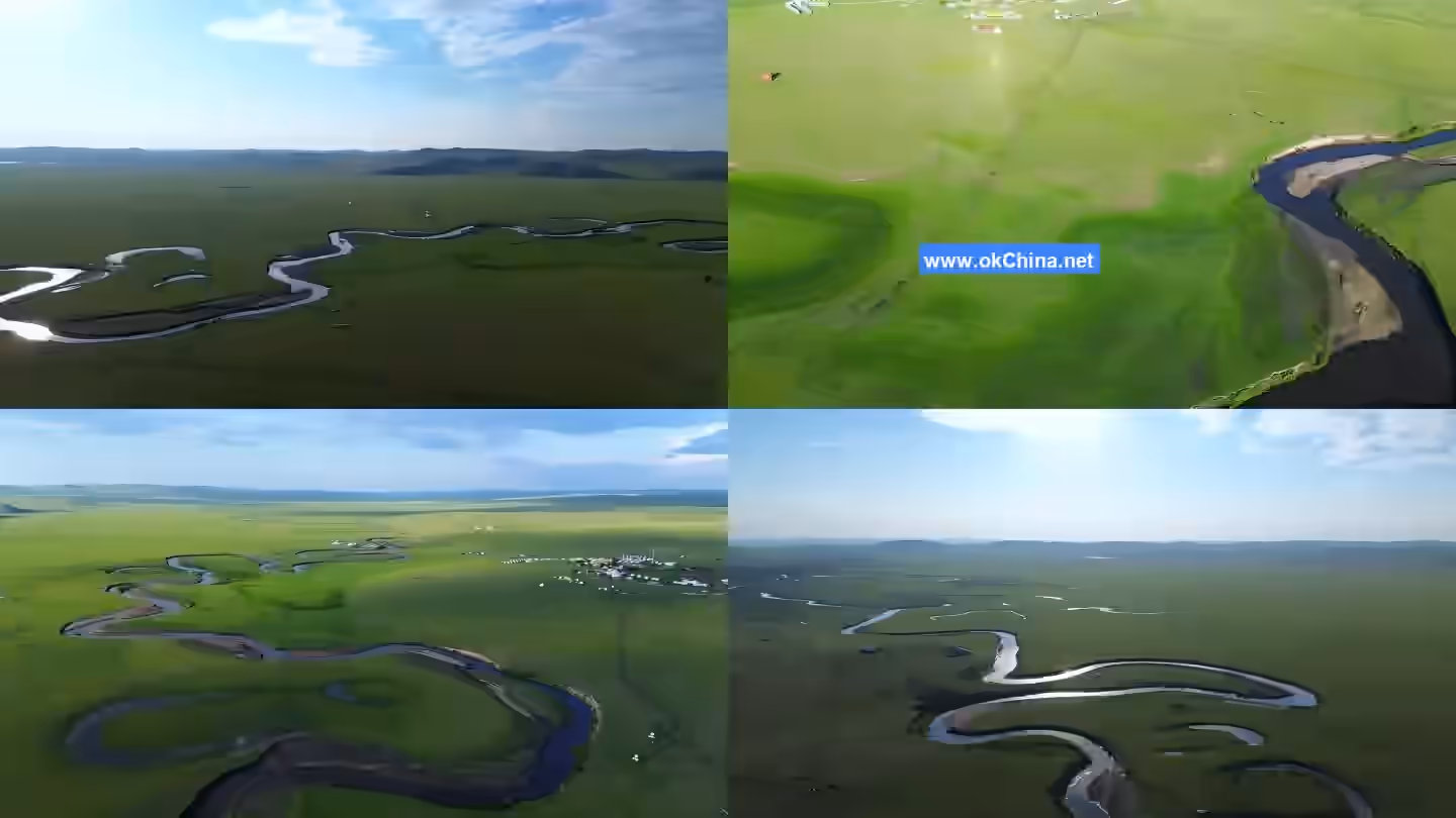
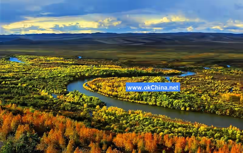
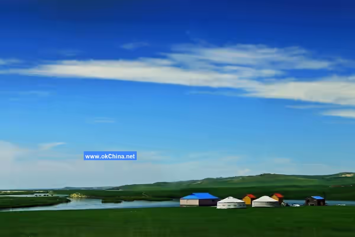
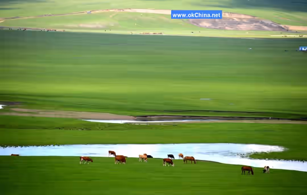
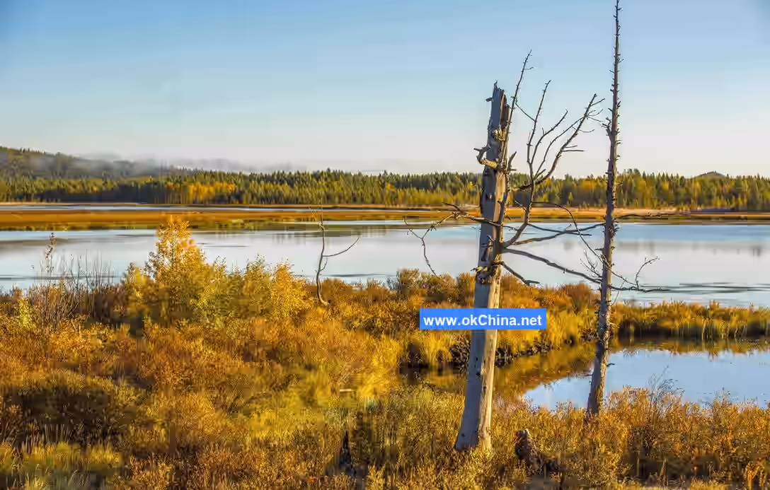
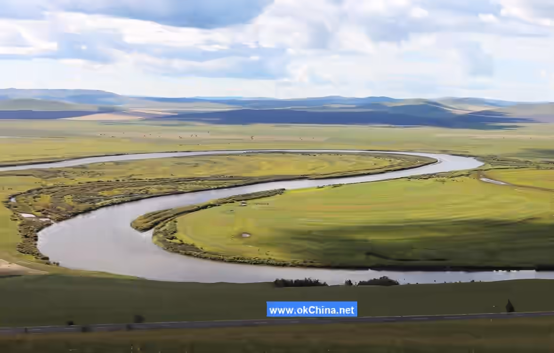
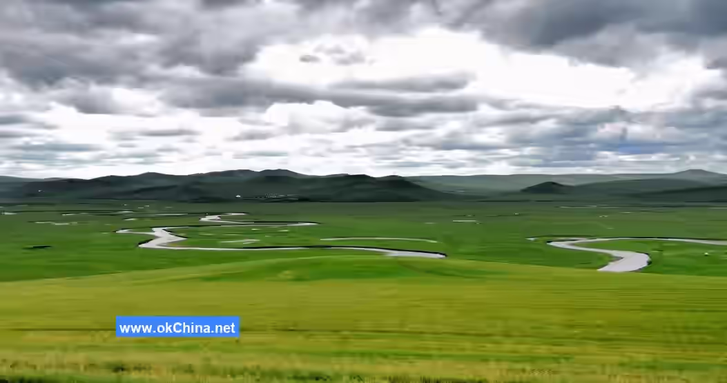
The Morgele River, a tributary of the Hailar River, which is the upper source of the Heilongjiang River, is also known as the Morigele River, Morigen River, or Morgen River. Its name is a transliteration from Mongolian, meaning "winding river" or "meeting river." It is located within Chen Barag Banner, Hulunbuir City, Inner Mongolia Autonomous Region. Originating from the western foothills of the Greater Khingan Mountains, it flows from northeast to southwest through the entire territory of Chen Barag Banner. The river is 319 kilometers long with a basin area of 4,987 square kilometers. Its main tributaries include Urdusurong, Hadehanhundi, Bilutuhundi, Hadatu River, and Ganjinggou. The terrain within the river basin is relatively flat and open, with a gentle river gradient. The river channel is meandering and winding, earning it the reputation of "the world's most winding river." Both banks are lush with water and grass, making it an excellent natural pasture. The lower reaches flow into Hoh Nuur Lake, exiting from the southeastern end of the lake to join the Hailar River.

II. Orientation and Layout (Introducing the scenic area's geographical location, climate, hydrology, flora and fauna resources, etc.)

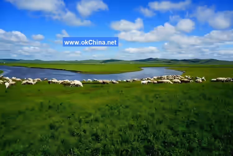
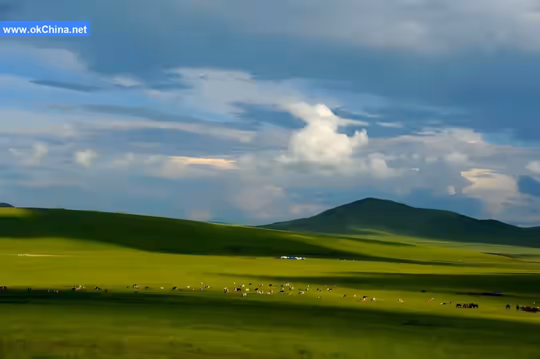
The Hulunbuir Grassland is located in the northeastern part of the Inner Mongolia Autonomous Region. It is a world-renowned natural pasture, one of the world's four major grasslands, acclaimed as the best grassland in the world, and one of China's top twenty tourist attractions. Situated west of the Greater Khingan Mountains, it is a collective term for the grasslands of New Barag Right Banner, New Barag Left Banner, Chen Barag Banner, Ewenki Banner, Hailar District, Manzhouli City, the southern part of Ergun City, and the western part of Yakeshi City. It spans approximately 350 kilometers from east to west and 300 kilometers from north to south, covering a total area of about 113,000 square kilometers. Over 3,000 rivers crisscross the area, and more than 500 lakes are scattered like stars. The terrain slopes from high in the east to low in the west, with elevations between 650 and 700 meters, showing a regular distribution from east to west. It spans three zones: forest steppe, meadow steppe, and arid steppe. Except for the eastern region, which accounts for about 10.5% of the area and is a transitional forest-steppe zone, the rest is mostly natural pastureland. Perennial herbaceous plants are the basic ecological characteristic of the Hulunbuir Grassland plant communities. The grassland boasts approximately over 1,000 plant species, belonging to 100 families and 450 genera.

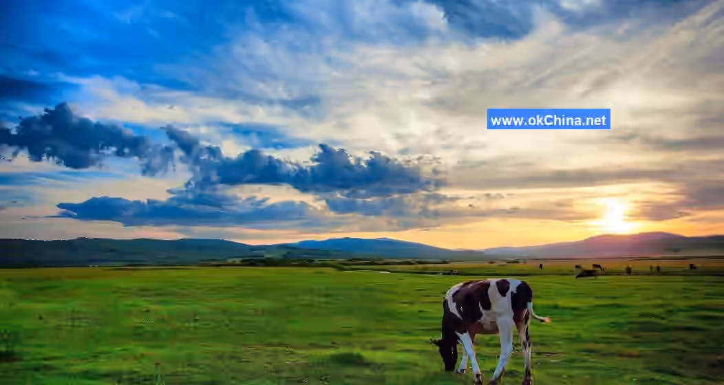
The Hulunbuir Grassland has four distinct seasons and is praised by the world as a beautiful garden. The average annual temperature on the Hulunbuir Grassland is around 0°C, with a frost-free period of 85 to 155 days. It experiences a temperate continental climate, falling within a semi-arid region, with annual precipitation of about 250–350 mm. The general climatic characteristics are: cold and dry winters, hot and rainy summers, with significant annual and diurnal temperature variations. Spring wheat, potatoes, and a small amount of vegetables can be cultivated.

The Hulunbuir Grassland · Morgele River Scenic Area is located in the core heartland of China's most beautiful grassland—the Hulunbuir Grassland. It centers around the most beautiful section of the Morgele River, known as "the world's most winding river," and encompasses folk cultural resources and domains typically represented by the original ecological nomadic production and lifestyle. The scenic area covers 51.42 square kilometers.

III. Key Scenic Spots (Introducing scenic spot features, topography, recreational activities, etc.)

Scenic Area Main Gate

The curved lines on the gate represent the Morgele River, "the world's most winding river." The circle above the sculpted arc represents the rising red sun over the grassland. At one end of the arc, a robust herdsman drives Mongolian horses, galloping swiftly.
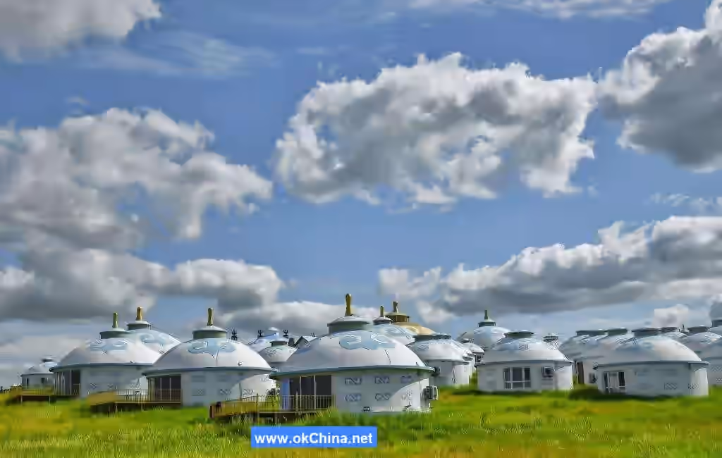
Visitor Center

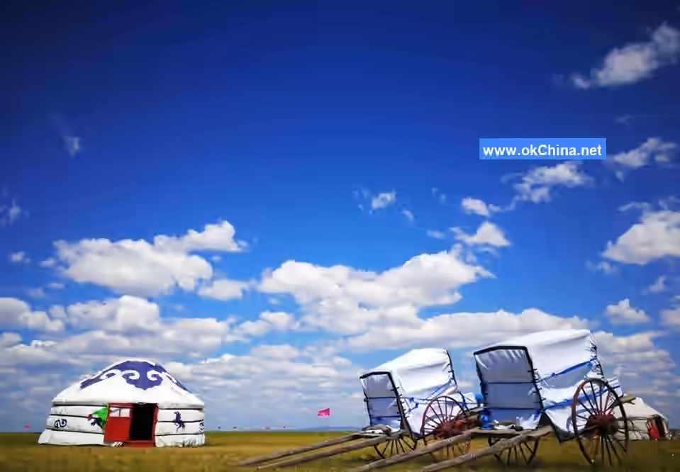
The main visitor center, located in the southern part of the scenic area, is constructed using traditional wooden structures, with the architectural form modeled after the most typical local dwelling on the grassland—the Mongolian yurt.

The visitor center is a two-story building. The first floor functions include attraction ticket sales, merchandise purchase, visitor inquiries, rental of accessibility equipment, as well as providing supporting services such as light meals and snacks, tea breaks, video screenings, and scenic shuttle bus transfers. It is a multifunctional one-stop service venue integrating dining, accommodation, transportation, sightseeing, shopping, and entertainment. The second floor houses the light meal and snack area, exhibition area, and office area.

Morgen Post Station

Morgen Post Station is the first post station in the scenic area. "Morgen" in Mongolian translates to "wise, intelligent." The post station covers an area of approximately 3,900 square meters, is constructed entirely of wood, and has a "品"-shaped layout.

At Morgen Post Station, you can not only witness the grandeur and vastness of the Morgele River but also immerse yourself in experiencing the remarkable wisdom and traces of production of the ancient nomadic civilization. You can enjoy a leisurely Morgele tea break and visit the Chen Barag Banner JD Specialty Store to savor the abundant fruits of nomadic production. Meanwhile, the post station interior includes functional service facilities such as consultation services, information inquiries, commercial services, and tourist restrooms. The corridors on both sides also provide spaces for rest and viewing.

Ajinai Post Station

"Ajinai" in Mongolian means "steed." In grassland nomadic culture, not all horses can be called "Ajinai." Only the horse that wins the championship at the grandest "Naadam" festival on the grassland can be called "Ajinai," carrying the auspicious meaning of "riding the champion steed."

Ajinai Post Station is the largest of the three viewing platforms in the scenic area, consisting of an entrance sculpture area, a landscape passageway, and a platform square, with rest corridors set up around it. The overall shape resembles a horse-head fiddle (Morin khuur). This viewing platform is relatively high in elevation, offering open vistas, allowing visitors to appreciate the Morgele River scenery from a new height. Additionally, the eagerly anticipated Haidongqing Mounted Police flag-raising ceremony can be viewed here daily at 09:30.

Muyun Mountain Top Hotel

Muyun Mountain Top Hotel is located at an excellent viewing point on the south bank of the Morgele River. It has been awarded the title of "Inner Mongolia Autonomous Region Internet Celebrity Check-in Spot" and is called "China's Most Beautiful Grassland Hotel" by netizens.

Morgele River Summer Pasture

The Morgele River Summer Pasture is located east of National Highway 332 in the northeastern part of Chen Barag Banner, Hulunbuir City, approximately 60 kilometers from Hailar District, the central city of Hulunbuir.

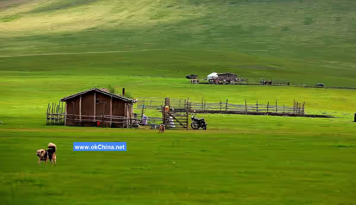
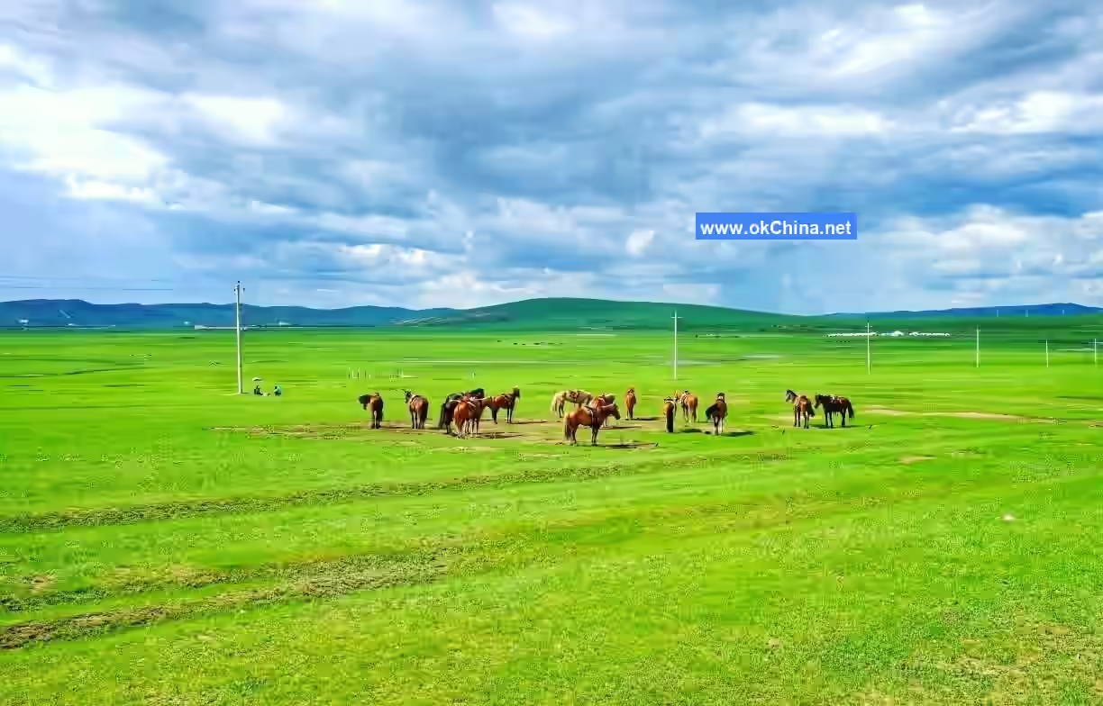
This area features lush water and grass, a cool climate, and pleasant scenery. It is the high-quality pastureland where herders from Chen Barag Banner have practiced seasonal migration for generations. Because the Morgele River runs from east to west through the summer pasture, this grazing land is called the Morgele River Summer Pasture. It is currently also the largest contiguous summer grazing land in Hulunbuir City and a scenic original ecological grassland. It is currently also the largest contiguous summer grazing land in Hulunbuir City and a scenic original ecological grassland.

Haolin Wenduri Post Station

"Haolin Wenduri" originates from Mongolian, meaning "high, far." The viewing platform is designed with the motif of "the sun and moon encircling," symbolizing ethnic unity. This viewing platform has a diameter of over 40 meters and is constructed entirely of wood. It is the viewing platform with the greatest height difference, offering extremely open views, allowing for a complete appreciation of the Morgele River scenery. Opposite it lies the scenic area's famous Horseback Mountain landscape. It is the highest viewing platform in the scenic area.

Morgele River

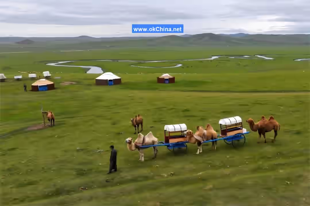
The Morgele River on the Chen Barag Grassland of Hulunbuir is locally known as the First Winding Water. This area is a tourist attraction featuring nomadic tribes as its landscape. It is a natural pasture of Hulunbuir. During the lush season, many nomadic herders gather here, forming a natural nomadic tribe. The Golden Horde Mongolian Tribe by the Morgele River is built according to the traveling camp of Genghis Khan, recreating the style of the Mongolian tribes of that era. Every summer, Mongolian and Ewenki herders from Chen Barag Banner practicing "Aot'er" (seasonal migration) naturally form a nomadic tribal community in this picturesque location with clear waters and lush grasslands.

Hulun Lake

Hulun Lake is a major scenic beauty of the Hulunbuir Grassland. Standing by the lake, one cannot see the opposite shore. By the lakeside, one often encounters sudden weather changes where a clear sky quickly turns stormy, bringing rain, while the sun in the west remains undimmed—a rare "sun shower."

IV. Cultural Resources (including myths, poems, famous figures, etc.)

Legends and StoriesLong, long ago, the grasslands were plagued by wind demons and sand monsters, leaving the land barren, water as precious as gold, livestock on the brink of extinction, and the bones of herders scattered everywhere. In a brave Mongolian tribe on the grasslands, there was a pair of lovers. The girl, named Hulun, was talented, beautiful, and skilled in singing and dancing. The boy, named Bell, possessed immense strength and was an expert rider and archer. To save the grasslands and pursue their love, they courageously battled the demons and monsters. They subdued the wind demons, eradicated the sand monsters, brought nourishing rain, and spread life, making the grasslands exceptionally beautiful. To express their gratitude and commemorate them, the people of the grasslands named their homeland Hulunbuir. This is the Hulunbuir Grassland, one of the world's three major grasslands, administratively known as Hulunbuir League (abbreviated as Hulun League).

Historical Records

From the book Visiting Ancient Inner Mongolia by historian Jian Bozan, it is known that the Hulunbuir Grassland is the cradle of China's ethnic minorities. Historically, the Xianbei, Khitan, Jurchen, and Mongol peoples all grew up in this cradle and spent their youthful eras here. From here, they marched westward to attack the gates of the Great Wall, entered the Yellow River basin, and stepped onto the stage of Chinese history. Hulunbuir is the backstage of the historical stage for China's nomadic peoples.

Folk Customs

Activities

  • Dismounting Wine and Songs of Welcome: When guests arrive at a Mongolian yurt on the grassland, the hospitable herders first offer dismounting wine, sing welcoming songs, and present hada scarves.
  • Tasting Ethnic Snacks: Inside the yurt, visitors can sample milk tea, dried milk curds, milk skin, cheese, fried millet, and more.

Worship at the Aobao

Worship at the Aobao is one of the grand sacrificial ceremonies of the Mongolian people. The Aobao is typically built on high mountains or hills, constructed from stones into a solid conical tower. At the top, a long pole is inserted, tied with livestock horns and scripture streamers, while around it are stones for burning juniper incense. Branches are placed around the Aobao, along with offerings such as whole sheep, mare's milk wine, butter, and cheese.

Wrestling

Wrestling is one of the most solemn competitive activities among the Mongolian people, having been a men's event at the Nadam Fair for over 700 years.

Archery

The bow and arrow were tools for hunting and important weapons for warfare and defense among the ancient Mongols. As early as 700 years ago, the Mongols were renowned worldwide for their riding and archery skills. Later, archery gradually evolved into a sport and has been passed down to this day.

Woriqie Dance

"Woriqie" means "swan" in the Evenki language. The Woriqie Dance is a folk entertainment dance of the Evenki people. The number of participants is unlimited, and both men and women can join. Usually, it involves a pair dancing while others watch and cheer. At the climax, men and women may join together, dancing in a group, with women often in the majority.

Lvrigeren

"Lvrigeren" means "dance" in the Oroqen language. The dance movements of the Oroqen people typically start slow and gradually speed up, ending with intense actions. Dancers usually perform without accompaniment, singing while they dance.

Comments

Post a Comment

Loading comments...