


Huanglong Scenic and Historic Interest Area
1. Introduction
The Huanglong Scenic and Historic Interest Area is located in Songpan County, Aba Tibetan and Qiang Autonomous Prefecture, Sichuan Province, covering an area of 700 square kilometers. It is the only well-preserved high-altitude wetland in China. It is 100 kilometers away from Jiuzhaigou, with an altitude ranging from 1,700 to 5,588 meters.
Huanglong is renowned worldwide for its "Four Wonders": colorful pools, snow-capped mountains, canyons, and forests. Adding to these are beach streams, ancient temples, and folk customs, collectively known as the "Seven Wonders." The scenic area consists of Huanglong Valley, Danyun Gorge, Munigou, Xuebao Peak, Xueshanliang, Hongxingyan, Xigou, and other scenic spots. The main landscapes are concentrated in the approximately 3.6-kilometer-long Huanglong Valley, which is covered with calcareous tufa deposits. Arranged in a terraced pattern, it is celebrated for its rich flora and fauna resources and enjoys reputations such as "World Wonder" and "Jasper Lake on Earth." It was inscribed on the UNESCO World Natural Heritage List in 1992. Besides alpine landscapes, various forest ecosystems, limestone formations, waterfalls, and hot springs can be found here. The area is also home to many endangered animals, including the giant panda and the Sichuan snub-nosed monkey.
Huanglong is renowned worldwide for its "Four Wonders": colorful pools, snow-capped mountains, canyons, and forests. Adding to these are beach streams, ancient temples, and folk customs, collectively known as the "Seven Wonders." Its natural landscapes include the main Huanglong Valley scenic area, Munigou scenic area, Xuebao Peak scenic area, Hongxingyan scenic area, Danyun Gorge scenic area, and the Great Grassland. Among these, the Xuebao Peak and Munigou scenic areas are located to the east of the main Huanglong Valley area, while the Danyun Gorge scenic area is situated to the west.
2. Scenic Area Resources
The Huanglong Nature Reserve features a complex and diverse ecosystem with high habitat diversity. The area boasts superior natural conditions, with towering mountains, deep valleys, and a wide range of altitudes. The habitats within the area can be roughly divided into eight types based on animal habitat characteristics.
From bottom to top, they are: evergreen broad-leaved forest, low mountain secondary shrubland, coniferous and broad-leaved mixed forest, coniferous forest, and alpine shrub meadow. Additionally, there are streams, buildings, and bare rock habitats. Generally, due to high habitat diversity and abundant food, the evergreen broad-leaved forest harbors the richest variety of mammals. This is followed by low mountain secondary shrubland, then coniferous and broad-leaved mixed forest, coniferous forest, and alpine shrub meadow. The bare rock, building, and stream habitats have the fewest species.
2.1 Calcareous Tufa Resources
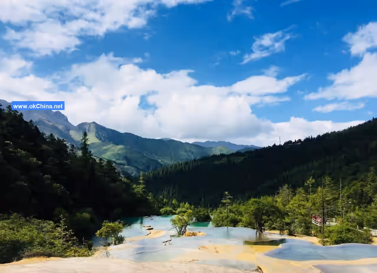
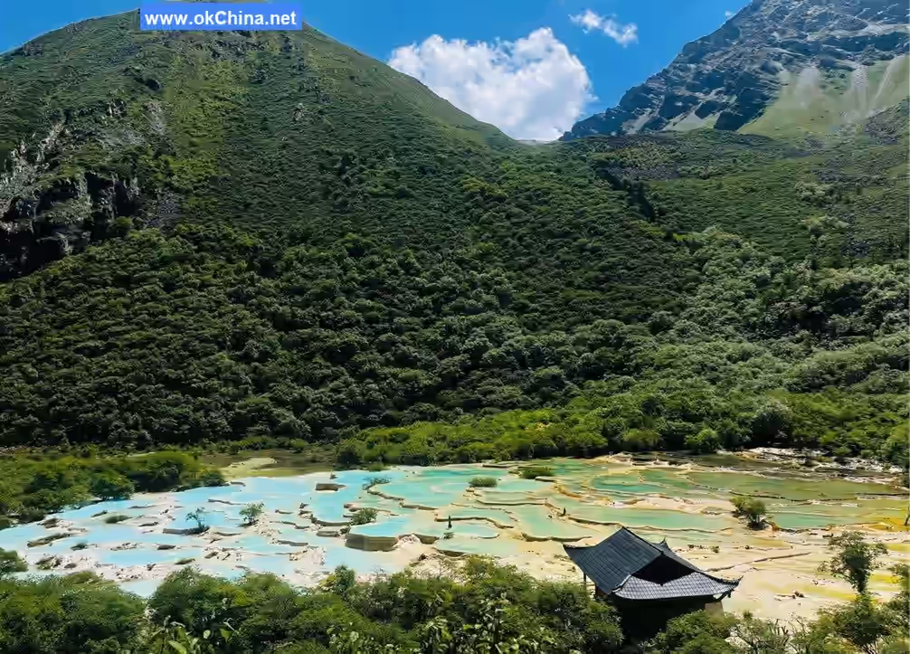
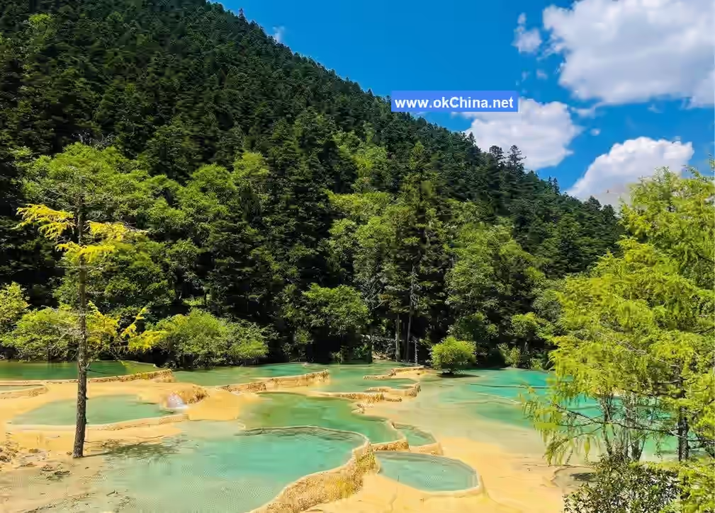
Huanglong's calcareous tufa landscapes are comprehensive in type, featuring calcareous tufa rimstone dam pools, tufa beaches, tufa fans, tufa lakes, tufa collapse lakes and pits, as well as tufa waterfalls, tufa caves, tufa springs, tufa platforms, tufa bonsai, and more. It is a veritable natural calcareous tufa museum. Its scale is immense: the continuously distributed calcareous tufa section in Huanglong Valley stretches for 3,600 meters, with the longest tufa beach being 1,300 meters long and 170 meters wide at its broadest point. There are over 3,400 colorful pools, and the highest rimstone dam reaches 7.2 meters. The Zhaga Tufa Waterfall stands at 93.2 meters high. These features rank among the best in China and are unparalleled in the world. Its distribution is concentrated: on the vast carbonate strata of the entire area, the calcareous tufa wonders are only concentrated in four valleys: Huanglong Valley, Zhaga Gully, and Erdaohai, within the elevation range of 3,000 to 3,600 meters. Its processes are complete: Huanglong Valley, Erdaohai, and Zhaga Gully within the area represent the modern formation period, decline period, and late degeneration period of calcareous tufa respectively, providing a complete field site for studying tufa succession processes. Its combinations are exquisite: within the 3,600-meter section of Huanglong Valley, almost all types of calcareous tufa are assembled simultaneously, ingeniously forming a golden "giant dragon" soaring among snow-capped mountains and forested seas.
2.2 Glacial Resources
The Huanglong area, above 3,000 meters in altitude, extensively exhibits clear Quaternary glacial relics, with the Xuebao Peak area of the Min Mountains being the most typical. Its characteristics include comprehensive types, dense distribution, and being the easternmost location. This area features high mountains over a vast range, with numerous peaks and ridges. There are seven peaks alone exceeding 5,000 meters, among which three modern glaciers have developed: Xuebao Peak (5,588 m), Xuelan Mountain (5,440 m), and Mendong Peak (5,058 m), making this region China's easternmost modern glacier preservation area. Main glacial erosion relics include horns (distributed above 4,000 m), arêtes (above 3,800 m), and glacial barrier lakes (above 3,900 m). Main glacial depositional landforms include terminal moraines, medial moraines, lateral moraines, and ground moraines, distributed in various glacial valleys. Terminal moraines are mainly distributed at elevations of 3,000–3,100 m, 3,550–3,650 m, and 3,750–3,850 m. Both modern glaciers and ancient glacial relics, as well as their relationship with calcareous tufa, hold significant scientific research value.
2.3 Animal Resources
The nature reserve is home to 221 species of vertebrates belonging to 54 families and 24 orders. These include 56 species of mammals in 18 families and 6 orders, 156 species of birds in 29 families and 12 orders, 5 species of reptiles in 3 families and 2 orders, 5 species of amphibians in 4 families and 2 orders, and 3 species of fish. National first-class protected animals include the giant panda, Sichuan golden snub-nosed monkey, takin, clouded leopard, leopard, Chinese monal, and Pallas's fish eagle. Second-class protected animals include the red panda, Asiatic golden cat, Pallas's cat, Eurasian lynx, sambar deer, red deer, forest musk deer, serow, blue sheep, Temminck's tragopan, Tibetan eared pheasant, Tibetan snowcock, blood pheasant, and blue eared pheasant. The reserve can serve as an in-situ gene bank for the genetic resources of certain wild animals.
Characteristics of the reserve's fauna include: a high number of rare species, with 23 species under national first or second-class protection; a clear phenomenon of mixing northern and southern animals, as the mountains and valleys run north-south, allowing warm, moist summer air currents to penetrate deep along the valleys, facilitating the distribution of southern animal groups northward and to higher altitudes; endemic Chinese animals include the giant panda, golden snub-nosed monkey, takin, as well as species only distributed in the Hengduan Mountains, such as the Scutiger glandulatus.
2.4 Plant Resources
According to incomplete statistics, the reserve has plants from 84 families and 1,300 species, characterized by a mixture of northern and southern species. The area contains nationally protected plants such as Cercidiphyllum japonicum, Tetracentron sinense, Sichuan larch, hemlock, and Chinese yew, as well as plants endemic to China or the area, such as Saussurea, Picea brachytyla, Magnolia officinalis, Sabina convallium, and Juniperus pingii var. wilsonii. The reserve has many species of spruce and fir, with arrow bamboo widely distributed, providing excellent habitat for giant pandas.
From the bottom of Huanglong Valley (2,000 m) to the mountaintop (3,800 m), the vegetation successively includes subtropical evergreen and deciduous broad-leaved mixed forest, coniferous and broad-leaved mixed forest, subalpine coniferous forest, and alpine shrub meadow.
2.5 Mineral Water Resources
Huanglong mineral water emerges in the Munigou scenic area. Its flow rate is 0.58 L/s, water temperature 9.5–9.8°C, pH 6.3, and mineralization 1,159 mg/L. Identified by relevant national departments, it is a high-quality natural drinking mineral water rich in strontium and carbon dioxide. Additionally, in the Erdaohai Gully of the Munigou scenic area, a group of hot springs emerges, with water temperature around 22°C. Large springs eject water columns over 30 cm high, containing hydrogen sulfide (H₂S) at 0.16 mL/L.
3. Main Attractions
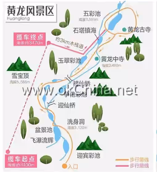
3.1 Huanglong Valley
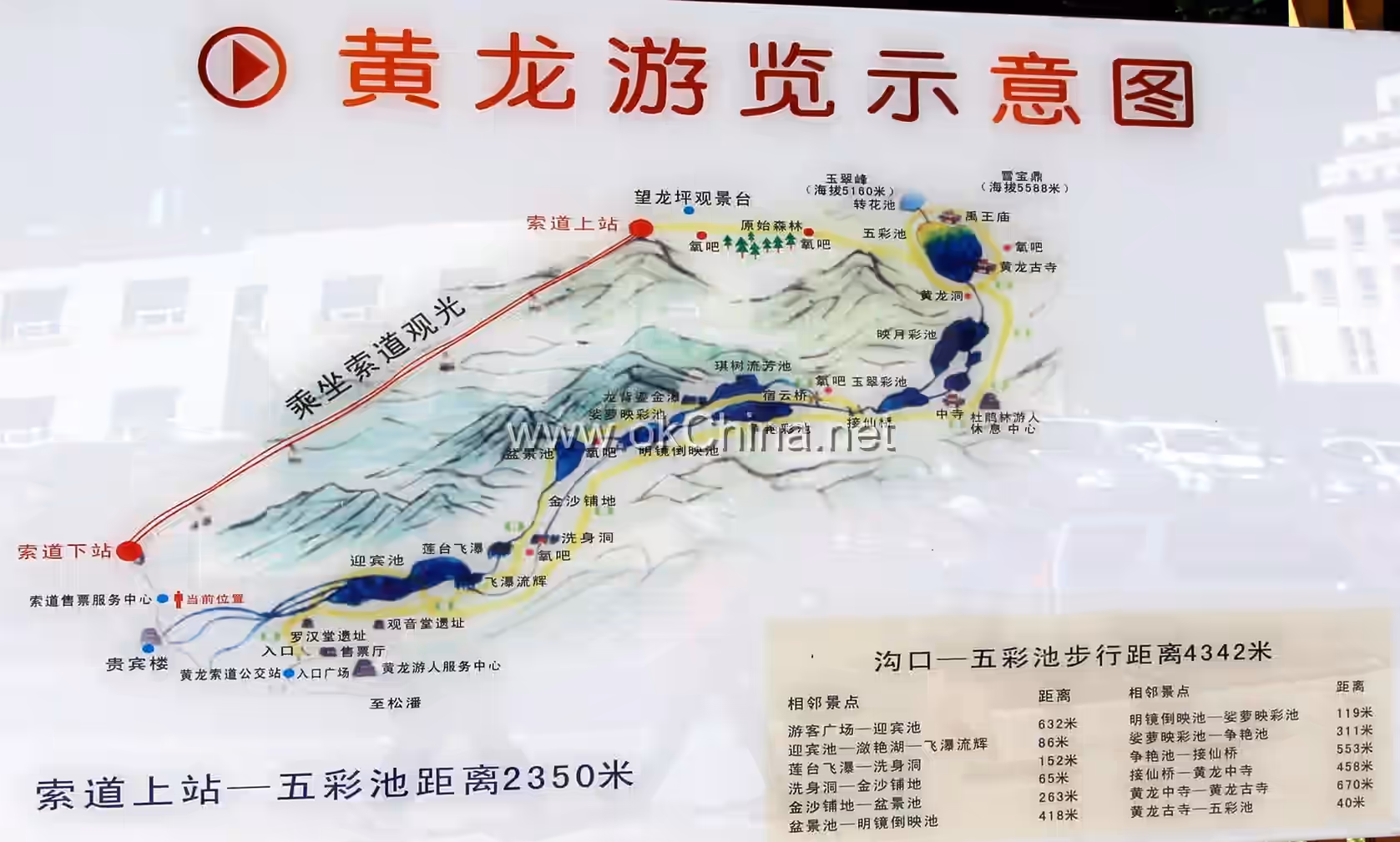
Located at the foot of Xuebao Peak, the main peak of the Min Mountains, and above the source of the Fujiang River—the Fuyuan Bridge—it is a gentle slope valley 7.5 km long and 1.5 km wide. The valley is filled with creamy yellow rocks, which from a distance resemble a winding yellow dragon in the dense forest and secluded valley, hence the name Huanglong (Yellow Dragon) Valley. During the Ming Dynasty (1368–1644 AD), the Huanglong Temple was built here to worship the Yellow Dragon. Huanglong Valley is famous at home and abroad for its natural landscapes of "uniqueness, extremity, beauty, and seclusion." It closely resembles the image of the "dragon" in the Chinese mind. Tibetans call it "Dongri Sercho," meaning the eastern conch mountain (referring to Xuebao Peak) and the golden lake (referring to Huanglong Valley). An annual grand mountain-circling temple fair is held here, attracting participants from various ethnic groups across northwestern provinces and regions. The continuously distributed calcareous tufa section in Huanglong Valley stretches for 3,600 meters, with the longest tufa beach being 1,300 meters long and 170 meters wide at its broadest point. There are over 3,400 colorful pools, and the highest rimstone dam reaches 7.2 meters.
3.2 Welcoming Pools
Upon entering the Huanglong scenic area, the first sight is a group of exquisite and uniquely shaped pools with clear water—the Welcoming Pools. The pools vary in size and shape, are brightly colored, and are arranged in picturesque disorder. They are surrounded by towering mountains, lush forests, wild flowers blooming on the slopes, and butterflies fluttering. The winding mountain stone paths are dotted with viewing pavilions, adding to the charm.
3.3 Body-Washing Cave
The Body-Washing Cave is 1,273 meters from the Fuyuan Bridge, situated on the second terrace of Huanglong Valley. The calcareous tufa flow descending from the Golden Sand Beach suddenly collapses here, forming a calcareous tufa collapse wall 10 meters high and 40 meters wide—the longest of its kind in the world. The rushing water cascades over the embankment, forming a magnificent, resplendent calcareous tufa waterfall on the wall. The Body-Washing Cave is located at the lower part of this tufa waterfall.
3.4 Bonsai Pools
The Bonsai Pools consist of a group of nearly one hundred pools, with pools within pools and pools encircling others. The pool embankments vary with tree roots, rhizomes, and terrain, connecting banks and sharing a common water source, layered according to the slope. The pool bottoms display various colors like yellow, white, brown, and gray, while the surfaces are clear and dust-free, resembling mirrors. Around and within the pools are wood, stones, flowers, and plants, with green cypress roots coiling, mountain flowers smiling, and wild fruits abundant. This splendid landscape, resembling a naturally created, peculiar bonsai garden, amazes even professional horticulturists.
This scenic area also includes the Mirror Reflection Pool close to the forest, the Poluo Colorful Pool hidden among azalea bushes, and the Contending Beauty Pool, which boasts over 500 colorful pools and is the most richly colored among the calcareous tufa landscapes.
3.5 Huanglong Temple
Located about 3.5 km from the valley entrance, the Middle Huanglong Temple provides a resting place for visitors. According to the "Songpan County Annals": "Huanglong Temple was built by Ma Chaojin, a Ming Dynasty military commander, also known as Snow Mountain Temple. It is said that the Taoist immortal Huanglong cultivated here, hence the name. There are front, middle, and rear temples, with halls and pavilions in sight of each other, each spaced five li apart."There were originally three temples in the valley—front, middle, and rear. Only the ruins of the front temple remain today. The middle temple consists of five halls, covering an area of approximately 5,100 square meters. The existing Guanyin Hall and its ten arhat statues are located at the end of Huanglong Valley, at an altitude of 3,558 meters, covering an area of 2,100 square meters. The temple buildings are largely well-preserved. Legend has it that Huanglong assisted Yu the Great in flood control, and later generations built a temple and erected a monument here to honor him. Another legend says that Huanglong Temple was built because Huanglong cultivated the Dao and attained immortality here. The main hall of the temple now houses a statue of Huanglong Zhenren, draped in a black Daoist robe, with a serene expression.
3.6 Flying Waterfall and Glowing Stream
Bidding farewell to the Welcome Pool and ascending along the winding plank path, one can see layers of emerald water breaking through dense forests, cascading down the slope. Over a rocky ledge about 10 meters high and more than 60 meters wide, dozens of stepped waterfalls pour down like rolling pearls, shimmering with silver light; like high-hanging water curtains, shrouded in mist and clouds; like silk gently flowing, graceful and elegant; like beaded curtains swaying, charming and enchanting. Behind the waterfall stands a steep cliff, mostly covered with calcified deposits resembling horse lungs and flakes, hanging as if about to drip, with a golden hue that makes the entire waterfall appear magnificent and grand. Bathed in the lingering glow of the sun, the waterfall reflects a spectrum of colors. From afar, it looks like a rainbow descending from the sky, exceptionally brilliant and dazzling, earning it the name "Flying Waterfall and Glowing Stream."
3.7 Munigou Scenic Area
The Munigou Scenic Area is located southwest of Songpan County and is a new addition to the Huanglong Scenic and Historic Interest Area. It combines the beauty of Jiuzhaigou and Huanglong but is more pristine and tranquil, without the hindrance of winter ice and mountain closures. Within the scenic area, mountains, forests, caves, and lakes complement each other. The forests stretch across the land, and the lakes, large and small, rival the colorful pools of Jiuzhaigou, while the calcified pools and waterfalls compete in splendor with Huanglong's "Jade Pools."
3.8 Zhaga Grand Waterfall
In the primeval forest of the Munigou Scenic Area, a massive torrent of water roars down from a 104-meter-high terraced travertine formation, as if pouring directly from the heavens, creating an extremely spectacular sight. This is China's largest travertine waterfall—the Zhaga Grand Waterfall. Located at an altitude of 3,270 meters, the waterfall is 93.2 meters high and 35 meters wide. Upstream is a lake, while downstream consists of a series of stepped riverbeds. Hundreds of layered, ring-shaped travertine waterfalls are connected like strings of pearls, cascading down three levels of travertine terraces, forming huge travertine surfaces and massive white blossoms. The roar of the waterfall is thunderous, combining sound and form. On the travertine wall of the second tier of the grand waterfall, there is a "Water Curtain Cave," where water cascades at the entrance, and the interior is filled with ever-changing wonders.
3.9 Splashing Jade Platform
The Splashing Jade Platform is a circular flat stone terrace. When the waterfall cascades from the mountain peak and falls onto this platform, the splashing spray resembles white jade. After traversing a steep plank path, visitors can reach the viewing platform at the middle section of the waterfall. Looking down from here, they can see the "Splashing Jade Platform" where pearls of water fly and jade-like droplets scatter. Leaving the viewing platform, the plank path becomes steeper. After passing a section of roaring waterfall, one reaches the source of the Zhaga Waterfall.
3.10 Erdao Lake
Erdao Lake is located in the northern section of the Munigou Scenic Area, separated from the Zhaga Waterfall by just a mountain. The name Erdao Lake has a long history, said to originate from the two main lakes: Small Lake and Big Lake. The "Songpan County Annals" also record: "Erdao Lake, west of Songpan City, behind Ma'an Mountain, two lakes connected like human eyes."
The Erdao Lake scenic area is a narrow mountain valley stretching 5 kilometers, connected by plank paths. Walking along the plank path from the camping area, visitors can admire Small Lake, Big Lake, Swan Lake, Emerald Lake, Rhinoceros Lake, and others. Each resembles pearls and gemstones—some hidden in dense forests, others exposed under the blue sky. The lake water is clear and transparent, mirror-like, with verdant forests reflected on the surface, creating a fresh and azure landscape. In summer and autumn, the lakes are filled with blooming white water lilies, blending flowers and water into a uniquely beautiful scene. The lakes are connected by plank paths, and several pavilions add a touch of rustic charm to the lake group.
3.11 Pearl Lake
Pearl Lake, also known as Boiling Pearl Lake, is said to have been created by celestial maidens who boiled pearls and refined springs here to create a healing bathing pool. The water temperature here is relatively high, remaining around 25°C even in the harsh, snow-covered winter. The strong smell of sulfur by the poolside attracts many people to bathe here, as it is believed to cure various skin ailments.
3.12 Red Star Rock
The Red Star Rock Scenic Area is distinguished by its numerous peculiar peaks, strange rock formations, and glacial barrier lakes formed by Quaternary glaciation. It is rarely visited by people, giving it a mysterious aura. Located on the eastern side of the Zhangla Basin and the western slope of the Min Mountains, the scenic area features high altitude and landscapes shaped by Quaternary glaciation, including peculiar peaks, strange rocks, and glacial barrier lakes. It is remote and shrouded in mystery. At an altitude of 4,300 meters lies "Red Star Lake," with an asymmetrical pentagonal shape, serene and beautiful, surrounded by blooming flowers. On the sheer cliff face in the middle of the precipice, there is a red rock cave that appears as if stained with blood. Its origin remains unknown. When clouds gather and winds rise, the cave is hidden in mist, but when sunlight shines, a faint red glow occasionally breaks through the clouds, creating an eerie and fantastical sight.
3.13 Xuebao Peak
Xuebao Peak is the main peak of the Min Mountains. With an altitude of 5,588 meters, it is located 50 kilometers east of Songpan County.
Xuebao Peak is covered in snow year-round, with rugged rocks on its slopes, crisscrossed ravines, and scattered lakes. There are 108 larger lakes, with the most famous being the "Four Seas": the mirror-like Southeast Round Sea, the fortress-like Southwest Square Sea, the crescent-shaped Northwest Semicircular Sea, and the pyramid-reflecting Northeast Triangular Sea. The foothills of Xuebao Peak are covered with flowers, grasses, shrubs, and towering pines and cypresses. This area is abundant in precious medicinal herbs such as fritillaria, rhubarb, and snow lotus, and is also a habitat and breeding ground for rare animals like blue sheep, mountain deer, and river deer.
The western, northern, and southern faces of Xuebao Peak are steep cliffs, daunting to climbers. Although the eastern and western slopes are gentler, they still inspire awe. A Sino-Japanese mountaineering team successfully reached the summit in 1999. After investigation, they concluded that this is a "famous mountain and precious ridge" with immense value for scientific research and the development of sports.
3.14 Sigou Scenic Area
The Sigou Scenic Area is about 12 kilometers from Huanglong Valley and is an open ancient glacial valley. The entrance area features flat and expansive alluvial terraces, where the ancient mountain town of Huanglong Village is located. The scenic area ranges in altitude from 2,700 to 4,200 meters, with complex and varied terrain, including towering peaks and open riverbank areas. The primeval forests, glaciers, and earthquake relics have maintained their original appearance through billions of years of changes, complementing the beautiful pastoral scenery. It is the closest scenic area to Huanglong Valley but with a completely different style.
The main natural landscapes in the scenic area are Quaternary glacial relics and primeval forests. The source of the valley consists of peculiar and diverse glacial erosion landforms and modern earthquake disaster landscapes. The sudden collapses of massive mountain terraces and the dramatic uplift of rock faults are often breathtaking.
In addition, the valley features high-altitude desert landscapes resembling "Gobi deserts" on the plateau. These are remnants of the intense "Himalayan orogeny" from ancient times. This area is a paradise for science enthusiasts and adventure seekers.
The watershed is covered with vast alpine meadow pastures. Standing on the watershed, one can overlook the diverse glacial barrier lakes at the source of Jiuzhaigou and the endless primeval forests. In ancient times, the famous "Long'an Horse Trail" of northwestern Sichuan passed through here, so the valley still retains wide horse paths. In recent years, such as 2009, visitors often dismount to ride horses or hike into the valley to enjoy the natural scenery of the primeval forests and alpine meadow pastures.
3.15 Danyun Gorge
Danyun Gorge, with its majestic canyon scenery, is one of the "Five Wonders" of Huanglong. It boasts a rich variety of tree species, shrubs, and flowers, making it a paradise for plant enthusiasts. The Danyun Gorge Scenic Area stretches from the Jade Bamboo Shoots Peaks to the Fan Cave, spanning 18.5 kilometers with a drop of 1,300 meters and peak-to-valley height differences ranging from 1,000 to 2,000 meters. In winter, the area is covered in snow; in summer, the mountains and forests are lush green. Especially in spring, when red azaleas bloom across the mountains, and in autumn, when maple leaves turn the gorge red, the scene resembles burning clouds under the setting sun descending from the sky—hence the name Danyun Gorge (Red Cloud Gorge). Mountains generate clouds, and trees create wind. Danyun Gorge almost daily sees mist rising from the forests, shrouding the mountains, appearing and disappearing intermittently. Danyun Gorge is densely forested, and the Fujiang River, originating from Xuebao Peak, rushes through the gorge, squeezed by strange rocks and cliffs, winding through the forests like a white dragon swaying its head and tail, echoing the nearby Huanglong.
Comments
Post a Comment