Anyang City Hongqi Canal - Taihang Grand Canyon Tourist Area
1. Introduction
The Anyang City Hongqi Canal - Taihang Grand Canyon Tourist Area is located in Linzhou City, Henan Province, at the junction of Shanxi, Hebei, and Henan provinces. It is 477 kilometers from the capital Beijing, 160 kilometers from the provincial capital Zhengzhou, and 50 kilometers from Anyang City. It is a National Key Scenic Area, a National AAAAA Tourist Attraction, a National Patriotic Education Base for Primary and Secondary Schools, a National Patriotic Education Demonstration Base, a National Water Conservancy Scenic Area, a National Key Cultural Relics Protection Unit, a National Geopark, a Chinese Red Tourism Scenic Area, a National Agricultural Tourism Demonstration Site, and a Creation and Training Base for the Chinese Federation of Literary and Art Circles Painting and Calligraphy Center.
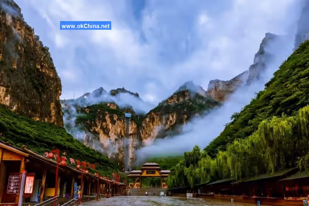
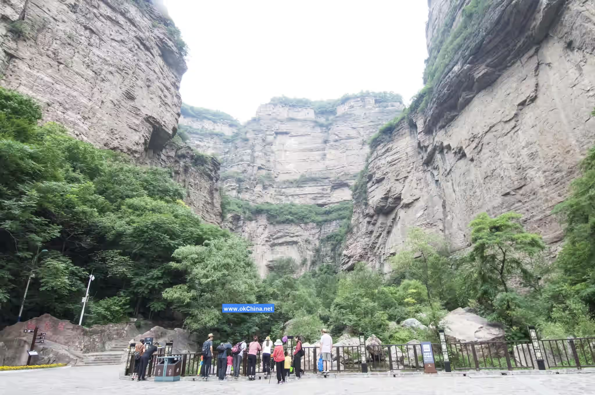
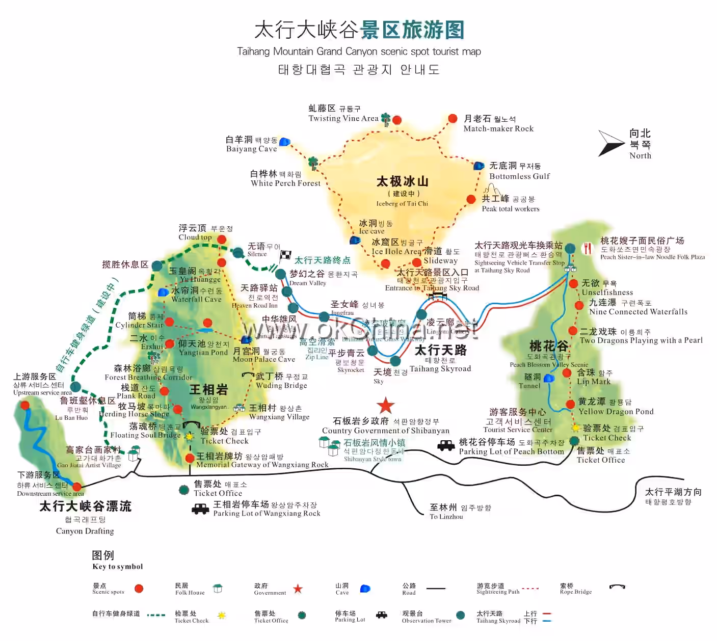
The Anyang City Hongqi Canal - Taihang Grand Canyon Tourist Area includes two main scenic areas: the Hongqi Canal and the Taihang Grand Canyon. The Hongqi Canal is known as the "Artificial Milky Way," the "Eighth Wonder of the World," and the "Great Water Wall of China." The scenic area includes the Hongqi Canal Youth Cave, the Hongqi Canal Diversion Garden, the Hongqi Canal Memorial Hall, and the Luosi Pond. The Taihang Grand Canyon is one of China's top ten most beautiful canyons, acclaimed as the most magnificent site of northern grandeur and the soul of the eight-hundred-li Taihang Mountains. It features three wonders: the Peach Blossom Valley where peach blossoms bloom in the severe cold of winter, the Taiji Mountain where water freezes in the scorching heat of summer, and the enigmatic Pig-Calling Stone. It also boasts eight major landscapes: the Soul of Taihang - Wangxiang Rock, the Deep Pools and Secluded Valleys of Xianxia Valley, the Jinpu Dragon Cave - a Small Paradise, the Primeval Forest of Taiji Mountain, the Illusory Xiantai Mountain, the Masterpiece of Nature - Luban Gap, the Unique in China Peach Blossom Waterfall, and the Taihang Pinghu Lake - Nangu Cave (Liuxiu Lake).
2. Geographic Environment
2.1 Location and Territory
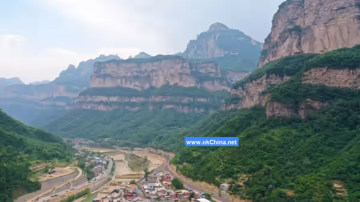
The Taihang Grand Canyon is situated at the border of Shanxi and Henan provinces, in the northwest of Linzhou, Anyang City, Henan Province. It stretches from Huishanjiao in Rencun Town in the north to Jingdi in Shanxi in the south. Formed by the Lushui River, a tributary of the Zhuozhang River, cutting through the Linlu Mountains, it is a deep canyon 50 kilometers long and 1.5 kilometers wide. It measures 50 kilometers from north to south and 4 kilometers from east to west, with an elevation ranging from 800 to 1739 meters and a relative height difference of over 1000 meters.
2.2 Topography
Shibanyan Town, where the Taihang Grand Canyon is located, features higher terrain in the south and west, and lower terrain in the north and east, characterized by four walls, eight cliffs, one gully, two banks, and twenty-eight gorges. The area is marked by towering cliffs, majestic peaks, interlocking terraces and walls, secluded valleys and peculiar peaks, rushing streams, and cascading waterfalls. The multitude of forms—peaks, ridges, terraces, walls, gorges, waterfalls, cliffs, and springs—creates the grand canyon scenery, making it a typical representative of northern landscape beauty.
2.3 Climate Characteristics
Shibanyan Town, home to the Taihang Grand Canyon, has a warm temperate semi-humid continental monsoon climate. However, influenced by the local unique topography, it exhibits distinct pure mountainous climate features. The four seasons are distinct with ample sunshine, characterized by warm springs, hot summers, cool autumns, and cold winters. The most notable feature among various meteorological elements is the significant temperature variation between cold and heat. Springs are dry with frequent droughts (nine out of ten years); summers see torrential rains causing disasters and flash floods; autumns are windy with clear, crisp skies; winters are cold with little rain and sparse snow.
3. Main Attractions
3.1 Hongqi Canal
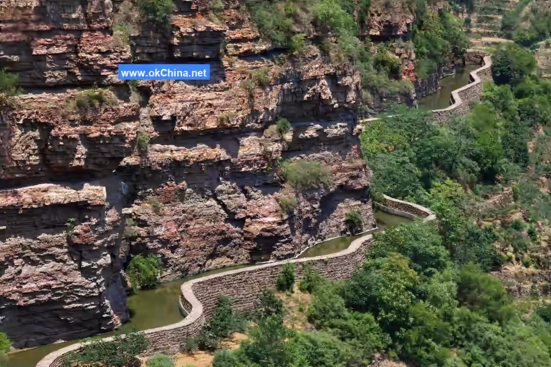
The Hongqi Canal Scenic Area is located in Rencun Town, Linzhou City. It is a National 5A Tourist Attraction, a National Key Scenic Area, a National Patriotic Education Demonstration Base, a National Water Conservancy Scenic Area, a Chinese Red Tourism Scenic Area, and a National Key Cultural Relics Protection Unit. The Hongqi Canal project commenced in February 1960 and was fully completed with its branch canal supporting works in July 1969, spanning over ten years. Sourcing water from the Zhuozhang River, a dam was built at Houbi Duan in Shicheng Town, Pingshun County, Shanxi Province, to divert the Zhang River water into Linzhou. Under extremely difficult construction conditions, the people of Linzhou, relying on the spirit of self-reliance and hard work, overcame numerous challenges. They labored on the cliffs of the Taihang Mountains and through dangerous rapids and gorges, tunneling through mountains and building bridges across gullies. They leveled 1250 hilltops, erected 151 aqueducts, excavated 211 tunnels, built 12,408 various structures, and excavated and laid 22.25 million cubic meters of earth and stone. If this amount of earth and stone were piled into a wall 2 meters high and 3 meters wide, it could stretch across the entire country from north to south, connecting Guangzhou and Harbin.
The main canal of the Hongqi Canal is 70.6 kilometers long, with a bottom width of 8 meters, canal wall height of 4.3 meters, a longitudinal slope of 1/8000, and a designed maximum flow rate of 23 cubic meters per second.
The completion of the Hongqi Canal fundamentally improved the harsh living environment of the Linzhou people who previously relied on rainfall. It solved drinking water problems for 567,000 people and 370,000 livestock, irrigated 540,000 mu of farmland, and increased grain yield per mu from 100 kilograms to 476.3 kilograms in 1991. It is called the "Life Canal" and "Happiness Canal" by the people of Linzhou. The Hongqi Canal project is not only massive in scale but also features superb construction techniques. Having stood firm on the Taihang Mountains for 40 years since its water delivery, architectural experts praise it as a model in Chinese architectural history, and it has become a landmark structure of Linzhou City.
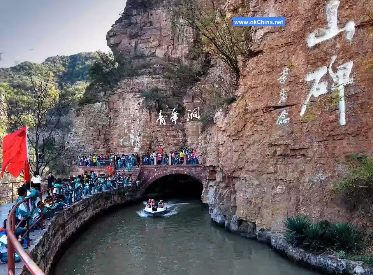
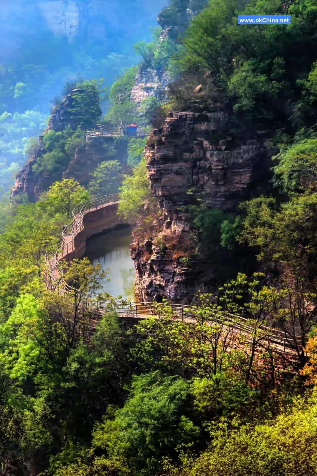
3.2 Youth Cave
The Youth Cave scenic area is located on the picturesque waist of the Taihang Mountains, built on steep cliffs and drifting among clouds and mist. It is the section where the hydraulic structures of the Hongqi Canal and the natural landscape blend most exquisitely, and also the most challenging section of the Hongqi Canal construction. The winding canal water is quite spectacular. Inscriptions and cliff carvings by leaders such as Jiang Zemin, Li Xiannian, and Guo Moruo adorn the area, adding charm to the mountains. The Hongqi Canal hanging on the mountainside resembles a symphony echoing through the Taihang Gorge, majestic and powerful—"Long heard of the Hongqi Canal, delighted to see it today." The "Thread of Sky," hailed as a "Unique Wonder of Taihang," is tranquil and profound—"To harbor lofty aspirations, please ascend the Thread of Sky." The Step Cloud Bridge spanning two mountains inspires awe with every step—"Dare to walk the heavenly path, stride across our Step Cloud Bridge." The 660-meter downhill slide offers thrilling and relaxing excitement—"Flying down three thousand feet, sitting steady on the slide." Inside the Youth Cave, touring by boat allows one to fully experience the unique feeling of "sailing on the Milky Way." Live performances like "Iron Girls Drilling" and "Risk Removal in Mid-Air" evoke nostalgia and thrill, taking you back to those unforgettable years. In spring, green trees provide shade; in autumn, red leaves cover the mountains. Climbing high and looking far, the scenery of three provinces unfolds before your eyes.
The Youth Cave Scenic Area features high mountains and dangerous waters. The Hongqi Canal hangs on the majestic cliffs of the Taihang Mountains, with the eight-meter-wide canal passing through the mountains, dotted with various cultural relics. The "Thread of Sky," a unique wonder under heaven, is praised as surpassing Huangshan and Emei. The emotionally evocative "Yangfengnao" allows a panoramic view, stirring feelings and filling one with delight. The heart-pounding "Iron Chain Bridge" lets one lean against the clouds in mid-air, floating like a celestial being. Climbing the cliff-hanging "Mid-Air Plank Road" embodies the ambitious spirit of arduous entrepreneurship. The relaxing and潇洒 "Slide" forms a stark contrast with the difficulty of ascending the mountain. A visit here not only allows one to appreciate the "majesty, danger, wonder, and beauty" of Taihang but also, through tangible examples of hard work like the Hongqi Canal, enables people to further comprehend the truth that "the people, and the people alone, are the motive force in the making of world history." It serves as a base for patriotic education for youth.
The Youth Cave is one of the main projects of the Hongqi Canal's main canal, located west of Lujia Guai Village in Rencun Town, passing through the ingeniously crafted, steep face known as "Little Ghost's Face." It is named "Youth Cave" because the assault team that participated in tunneling consisted of 300 outstanding young people selected from migrant workers across the county.
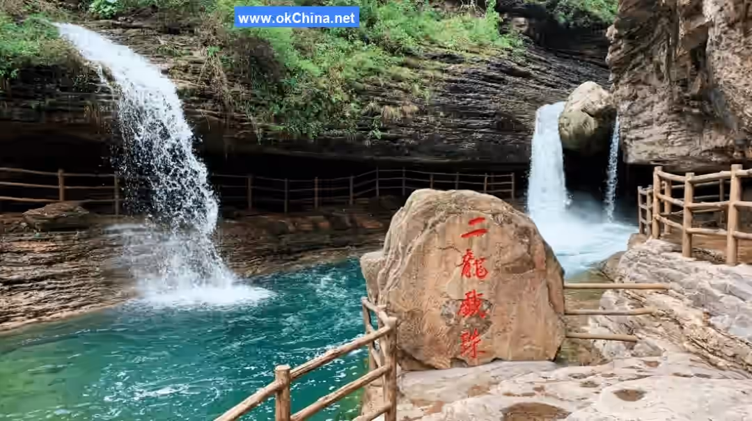
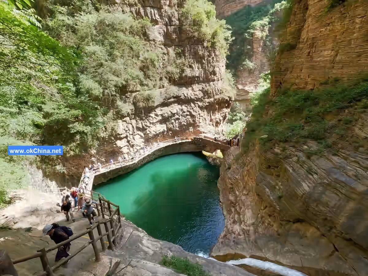
3.3 Luosi Pond
Luosi Pond is one of the main attractions in the Hongqi Canal scenic area, located about 1 kilometer west of the Hongqi Canal Youth Cave, below Niulingshan Dongnao Village. It is also called "Tianqiao Duan" (Heavenly Bridge Break).
Luosi Pond gets its name from its depth, said to be as deep as a skein of silk. Also, because the Zhuozhang River has "nine gorges and eighteen breaks," this spot is a larger break with a waterfall. Above it is a canyon cable bridge connecting Henan and Hebei provinces, hence the name "Tianqiao Duan" (Heavenly Bridge Break).
Here, unique canyon scenery is complemented by magical and wonderful legends. The river water plunges from the canyon cliff into a waterfall, resembling a white horse or jade dragon, roaring and tumbling into the Luosi Pond, which is a hundred meters deep. In winter, ice curtains tens of meters long hang on both the Henan and Hebei banks, narrating the 1-billion-year formation history of the Luosi Pond rocks.
Especially during the rainy summer season, the swollen river surges and plummets into the canyon, sounding like thunder, its momentum resembling the Hukou Waterfall, forming a magnificent spectacle. An ancient iron chain bridge spans the canyon, connecting Hebei and Henan provinces. Walking on this heavenly bridge is like treading on clouds in the highest heavens.
Viewing the flying torrents and turbulent waves from the side, looking down into the deep ravine and secluded pond, with rainbows hanging, offers infinite delight. On the south side of the canyon, the torrent has carved out a natural stone cave, a masterpiece of nature, reaching a hundred meters deep. Descending along a spiral staircase leads to the Divine Turtle Cave. Legend says a divine turtle resides here specifically to rescue drowning creatures. Hence the saying, "After seeing Luosi Pond, why go to Jiangnan (south of the Yangtze)?"
Luosi Pond is also known as "Leisi Pond" (Tears of Longing Pond). Legend has it that after the Seventh Fairy and Dong Yong parted, she longed for her husband day and night but could not cross the Milky Way drawn by the Queen Mother to meet her lover. She wept incessantly, her tears like broken strings of pearls. Over time, they dripped and formed this deep pond. The pond water is clear, with rippling blue waves. One can take a boat ride through the canyon to enjoy the charming scenery of the "Little Three Gorges."
3.4 Diversion Garden
Here, the main canal of the Hongqi Canal divides into three trunk canals, which travel along the mountains deep into the hinterland of Linzhou, nourishing 540,000 mu of fertile land in Linzhou. This structure is 6.5 meters long, 12 meters high, and 13.5 meters wide, with a gate bottom elevation of 454.44 meters, 10.31 meters lower than the elevation of the canal head intake gate. Above the gatehouse, the three large characters "Hongqi Canal" by Guo Moruo are held high, making it one of the landmark structures of the Hongqi Canal.### 3.5 Peach Blossom Valley Peach Blossom Valley features the Peach Blossom Cave where flowers bloom in the depths of winter, the Ice-Back area where water freezes in the height of summer, a 346-meter-high mountain waterfall, and the Flying Dragon Gorge with interconnected pools and cascades... As a poem attests, "Peach blossoms bloom at the cave mouth amidst snow, Waterfalls hang from cliff tops among the clouds." It can truly be called a blessed paradise, a fairyland on earth. Peach Blossom Valley is a valley within a valley, approximately 4 km long, with an elevation ranging from about 800 m to 1736 m, a height difference of nearly a kilometer. Within the valley, strange peaks rise abruptly, steep and majestic. A winding Peach Blossom Stream runs through the canyon, with hanging grasses and vines on both banks and vast, boundless mixed forests. The surging green tide, moved by the mountain wind, resembles rolling seawater. The scenic Peach Blossom Valley, known as the Valley of Love, transforms as the mist disperses and clouds shift over the mountains; flowers bloom and birds sing. High mountain waterfalls plunge hundreds of feet, spring-fed pools are clear as mirrors. The stream flowing down the valley drops into waterfalls, which then form pools, one after another, creating the valley's charming landscape of majestic mountains and elegant waters. Every step in Peach Blossom Valley offers a new view, with scenes seamlessly connected. Attractions like Huanglong Pool, Flying Dragon Gorge Waterfall, Flying Dragon Gorge Plank Walkway, Nine-Connected Waterfalls, and Peach Blossom Cave complement each other perfectly, displaying the profound and serene artistic conception of beauty hidden within deep gorges.
3.6 Wangxiang Rock
The Wangxiang Rock scenic area borders the Lushui River to the east and leans against cliffs to the west, with steep cliffs encircling its left and right sides, forming a highly enclosed valley. It faces the Zhuque Peak, which spreads out like a rock screen, subtly aligning with the ideal model of ancient Chinese geomancy: "Azure Dragon on the left, White Tiger on the right, Vermilion Bird in front, Black Tortoise behind." This has attracted famous scholars and refined individuals throughout history to cultivate themselves and live in seclusion here. According to records, King Wuding of the Shang Dynasty and his prime minister Fu Yue, who was born a slave, both lived here, hence later generations named it Wangxiang Rock (King and Minister Rock). Wuding was the 22nd king of the Shang Dynasty. In his youth, his father, Xiao Yi, sent him to work and live with slaves on Mount Linlü west of the Shang capital, where he became friends with the slave Fu Yue. Wuding believed Fu Yue possessed great talent and vision. After succeeding to the throne, Wuding appointed Fu Yue as his prime minister. Upon taking office, Fu Yue devoted all his literary and military talents to assist Wuding in governing the court orderly, leading the Shang Dynasty to unprecedented development, a period historically known as the "Wuding Restoration."
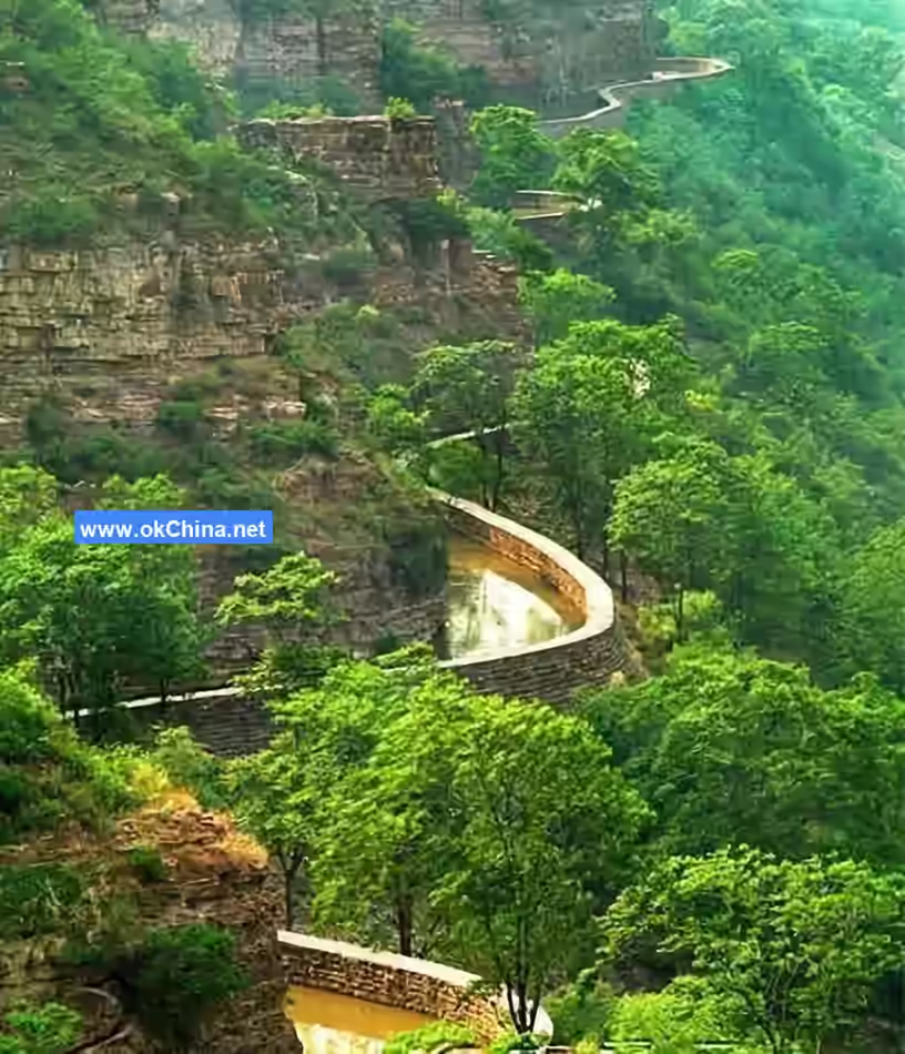
3.7 Taihang Sky Road
The "Taihang Sky Road" scenic area is located atop the Taihang Mountains, stretching about 30 km from the Peach Blossom Valley scenic area in the north to the Fairy Glow Valley scenic area in the south. It is not only an important part of the scenic area's circular tour route but also an excellent vantage point for overlooking the magnificent scenery of the Taihang Mountains.
Traveling along the Taihang Sky Road by sightseeing vehicle is like being in a hundred-mile gallery. Everywhere you look, there are grand, sweeping landscape scrolls of traditional Chinese painting. The deep canyons and sheer cliffs provide visitors with a powerful visual impact. Following the mountain's contours, over ten viewing platforms are set up along the Taihang Sky Road. Leaning on the railings and gazing into the distance makes one feel open-hearted and free from distracting thoughts.
3.8 Taiji Ice Mountain
The Taihang Ice Mountain is said to be the remnant of Pangu's creation of heaven and earth. Hundreds of millions of years ago, Pangu, who gestated in chaos, broke free from his bonds, separated heaven and earth, and created the sun, moon, stars, mountains, and rivers. Massive rocks imbued with the essence of heaven and earth scattered here, forming the mysterious Taiji Ice Mountain.
The Taiji Ice Mountain scenic area features lush forests, rugged ridges and strange peaks, winding paths, flocks of resting birds, and hares and badgers roaming the wild mountains, composing a vibrant picture of a primitive forest. At Taiji Ice Mountain, one can personally experience the natural wonder of reversed seasons: during the intense heat of midsummer, chunks of ice can still be seen in mountain caves (Ice-Back); in the bitter cold of midwinter, peach blossoms can be seen budding at cave entrances (Peach Blossom Valley).
3.9 International Paragliding Base
The Linlü Mountain International Paragliding Base is located in Luban Village within the Taihang Grand Canyon scenic area of Linzhou City. The take-off point is at an altitude of 1190 m, with a relative height difference of 700 m, a steep slope of 60 degrees, a flat top, and sheer sides like a cut. Influenced by the unique geographical location and terrain relationship between the Taihang Mountains and the Linzhou Basin, air currents rise along the cliffs, creating a natural environment for paragliding.
Since first organizing a paragliding event in 1992, the annual international paragliding competition has become an important tourism brand for Henan Province. After years of careful development, the paragliding base now has facilities that can accommodate 30 athletes taking off simultaneously. It holds significant influence in domestic and international paragliding circles and has been praised by the FAI as "Number One in Asia, First-Class in the World." Wandering through the Taihang Grand Canyon and watching the dots of gliding sails in the sky further accentuates the magnificent scenery of the grand canyon.
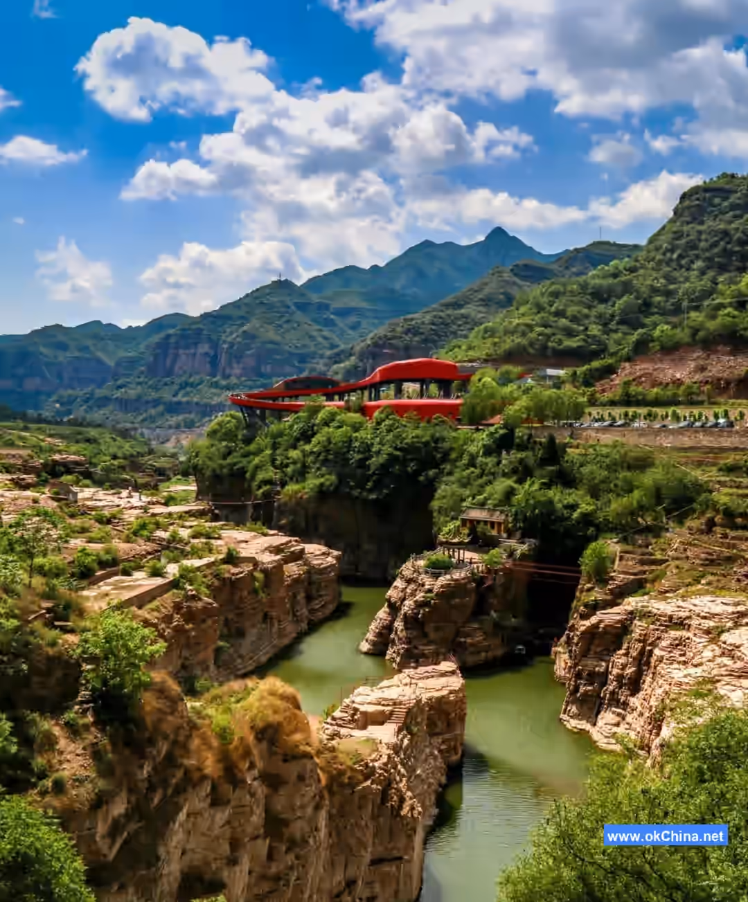
3.10 Taihang Pinghu Lake
Taihang Pinghu Lake, also known as Nangudong Reservoir, is the water storage project for the "Lushui River" within the scenic area. Due to the construction of the dam, a high gorge flat lake landscape, about 5 km long and 0.5 km wide, has formed within the Taihang Grand Canyon scenic area. It also serves as a supplementary water source project for the "Artificial Sky River," the Red Flag Canal.
Taihang Pinghu Lake is the vibrant heart of the Taihang landscape. Green mountains stack along the lakeshore, the water surface shimmers, and the posture of the Taihang Mountains is reflected in the water, further highlighting the mountains' grandeur and the water's gentleness. The excellent scenery not only attracts many tourists but has also made Taihang Pinghu Lake an important location for film and television productions.
The Taihang mountain area is cool in summer and severely cold in winter. The fish, shrimp, and aquatic products growing in Taihang Pinghu Lake, affected by the environment, grow slowly and have delicious flesh. Wandering through the Taihang landscape and tasting these delicacies is also a memorable aspect of Grand Canyon tourism.
3.11 Fairy Glow Valley
The Fairy Glow Valley scenic area is located near Gaojiatai Village in the southern part of the Taihang Grand Canyon scenic area. It is a valley within the Taihang Grand Canyon, approximately 4.5 km long and 0.5 km wide. It is a beautiful landscape that has maintained its pristine natural features and has now become the preferred destination for hiking enthusiasts, art lovers, and photography enthusiasts.
Within the canyon, streams murmur, and there are numerous pools and waterfalls. Strange peaks stand on both sides, with steep and perilous mountain terrain. Birds sing in the mountain streams, and a gentle breeze brushes the face, making it a tranquil place for people to temporarily forget the noise of the city and dispel various worries. Strolling leisurely here allows for both physical relaxation and mental liberation.
With the continuous extension of the "Taihang Sky Road" scenic area's circular bus route, Fairy Glow Valley will change its current status of being "hidden deep in the mountains and unknown to people," becoming a desired tourist destination for more visitors.
4. Culture
4.1 Film and Television Works
Films from the 1960s such as Ode to the Shoulder Pole Spirit, Li Shuangshuang, Dragon Horse Spirit, and Red Rain from the 1970s, the new version of Guerrillas on the Plain, Silver Screen Romance from the 1990s, as well as TV series like Aunt Zheng's Contract and The Story of the Red Flag Canal have all been filmed in the Grand Canyon.
4.2 Folk Art
"Flower Stick Dance" is a local folk performing art popular in villages throughout the Grand Canyon scenic area. The flower stick is about eyebrow-height, with holes at both ends containing rings to which small bells are attached. Following fixed patterns, striking the limbs, shoulders, back, waist, and other parts produces rhythmic sounds. Patterns include single-file circular procession, double-file advance, and交叉穿插 (crossing and穿插). It was mainly used for welcoming and seeing off soldiers and for festive celebrations. "Flower Stick Dance" has become an important performance program in the scenic area, with strong participatory and entertainment value. Visitors can see this art form at the viewing platforms along the Taihang Sky Road and can personally participate.
5. Historical Development
5.1 Red Flag Canal
5.1.1 Construction Background
The Red Flag Canal is located in Linzhou City, Henan Province, at the junction of Henan, Shanxi, and Hebei provinces. Historically, the area faced severe drought problems. From 1436 to 1949, Lin County (now Linzhou City) experienced over 100 natural disasters, including more than 30 major droughts leading to crop failure, even resulting in the tragic situation of "cannibalism." Although water conservancy projects were built multiple times throughout history (e.g., the Tianping Canal in the Yuan Dynasty, the Xie Gong Canal in the Ming Dynasty), the water shortage problem was never彻底解决. After the liberation of Lin County in 1949, the county government constructed several water conservancy projects, but limited water sources still could not meet large-scale irrigation needs. Ultimately, Lin County decided to divert water from the Zhuozhang River outside its territory.
5.1.2 Project Construction
In 1959, the Lin County Party Committee decided to implement the "Divert Zhang River into Lin" project, which officially commenced in February 1960. The project was named the "Red Flag Canal," symbolizing advancing with the red flag held high. During the difficult period of the three years of natural disasters, the people of Lin County, relying on 150 mu of cultivated land, 3 million yuan in reserves, and 28水利技术人员, fought for ten years. The main canal began carrying water in 1965, the construction of three branch canals was completed in 1966, and the project was fully finished in 1969, forming an irrigation system centered on the Red Flag Canal, effectively irrigating 540,000 mu of land.
5.1.3 Scenic Area Development
In the 1990s, the Red Flag Canal began transforming into a tourist attraction, centering on the Red Flag Canal project and combining it with the natural scenery of the Taihang Mountains to create the Red Flag Canal Watershed Divide and Youth Cave scenic spots. Multiple national leaders have personally inspected the site, highly praising the Red Flag Canal spirit. In 2005, Anyang City proposed nominating the Red Flag Canal as a UNESCO World Heritage site. In 2013, the Red Flag Canal Economic Development Zone was upgraded to a National Economic and Technological Development Zone, becoming the 8th such zone in Henan Province and the first in central and western China.
The Red Flag Canal is not only a miracle of hydraulic engineering but also a symbol of the spirit of self-reliance and arduous entrepreneurship, leaving valuable spiritual and material wealth for future generations.
5.2 Taihang Grand Canyon#### 5.2.1 Geology
The formation of the Taihang Grand Canyon in Linzhou, Anyang City, Henan Province, is primarily the result of the combined effects of geological evolution, river incision, and climatic processes. Geotectonically, the region has undergone over 2.5 billion years of terrestrial-marine transitions and plate movements. Following the crustal uplift during the mid-Triassic period, the Taihang Mountains gradually took shape, while the fault-induced subsidence of the North China Plain plate further intensified the canyon's deep incision. Fluvial erosion, particularly the cutting action of the Lushui River, a tributary of the Zhuozhang River, sculpted the canyon's steep cliffs and deep valley floor, creating the distinctive Zhangshiyan landform. Additionally, torrential rains, mountain floods, and freeze-thaw cycles under the warm temperate semi-humid continental monsoon climate have further promoted the canyon's development. The interplay of these natural forces has shaped the magnificent Taihang Grand Canyon as seen today.
5.2.2 Human Culture
Ancient History The Linlü Mountain area, where the Taihang Grand Canyon is located, has been a significant region for human activity since ancient times. During the Shang Dynasty, King Wuding and his prime minister Fu Yue once lived in seclusion here, leaving behind the historical legend of "Wangxiang Rock."
The Eastern Han Dynasty notable Xia Fu sought refuge and seclusion here to escape the "Proscription of the Partisan Disasters," while the Ming Dynasty Taoist priest Zhao Dexiu also cultivated himself in this area.
Modern Development In the 1960s, the people of Linzhou constructed the Red Flag Canal in the Taihang Mountains. This artificial "sky river" not only resolved local water supply issues but also became a significant cultural landscape within the Taihang Grand Canyon.
In the 1990s, the Taihang Grand Canyon began development as a tourist destination, gradually forming a tourism system centered around Taohua Valley, Wangxiang Rock, and the Taihang Sky Road.
Comments
Post a Comment