


Daocheng Yading
1. Introduction
The Daocheng Yading Scenic Area in Ganzi Tibetan Autonomous Prefecture, abbreviated as the Daocheng Yading Scenic Area or Yading Scenic Area, is a tourist attraction located within Xianggelila Town, Daocheng County, Ganzi Tibetan Autonomous Prefecture, Sichuan Province. The scenic area covers an area of 1,072.3 square kilometers.
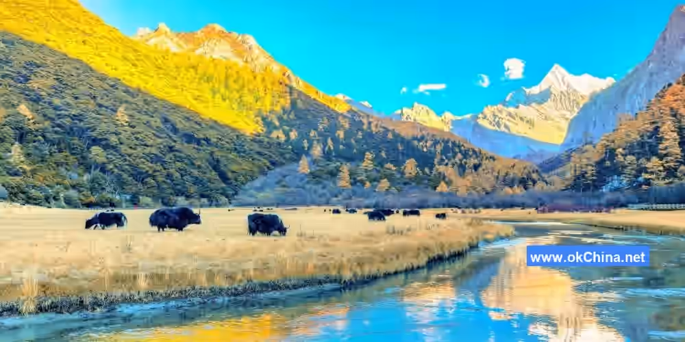
The Tibetan name for the Yading Scenic Area is "Nianqing Gongga Risong Gongbu," meaning "the sacred land of the three great protective snow mountains." Development began in 1996, and the area was named after the small Tibetan mountain village "Yading" within it, a name that has been used ever since. Within the Yading Scenic Area, the northern peak "Xiannairi" represents the Bodhisattva Guanyin (Avalokiteshvara) and stands at 6,032 meters. The southern peak "Yangmaiyong" represents the Bodhisattva Manjushri and stands at 5,958 meters. The eastern peak "Xianuoduojie" represents the Bodhisattva Vajrapani and also stands at 5,958 meters. The forests within the area remain in a pristine state, covering 560 square kilometers, and are home to 1,126 species of vascular plants and 291 species of vertebrates. The area boasts over 10 peaks exceeding 5,000 meters in altitude and more than 30 peaks above 4,500 meters. There are 62 ancient glacial lakes at high altitudes, with "Milk Lake," "Five-Color Lake," and "Pearl Lake" being the most spectacular. Renowned both domestically and internationally, Yading is a rare comprehensive landscape area that integrates modern glaciers, Quaternary ancient glaciers, ancient glacial lakes, primeval forests, high plateaus and mountains, river wetlands, alpine gorges, and geothermal hot springs. Due to its unique landforms and pristine natural scenery, the Daocheng Yading Scenic Area is hailed as "the soul of China's Shangri-La" and praised by international friends as "the last pure land on the water-blue planet." It is a paradise for photography enthusiasts.
2. Geographical Environment
2.1 Location and Territory
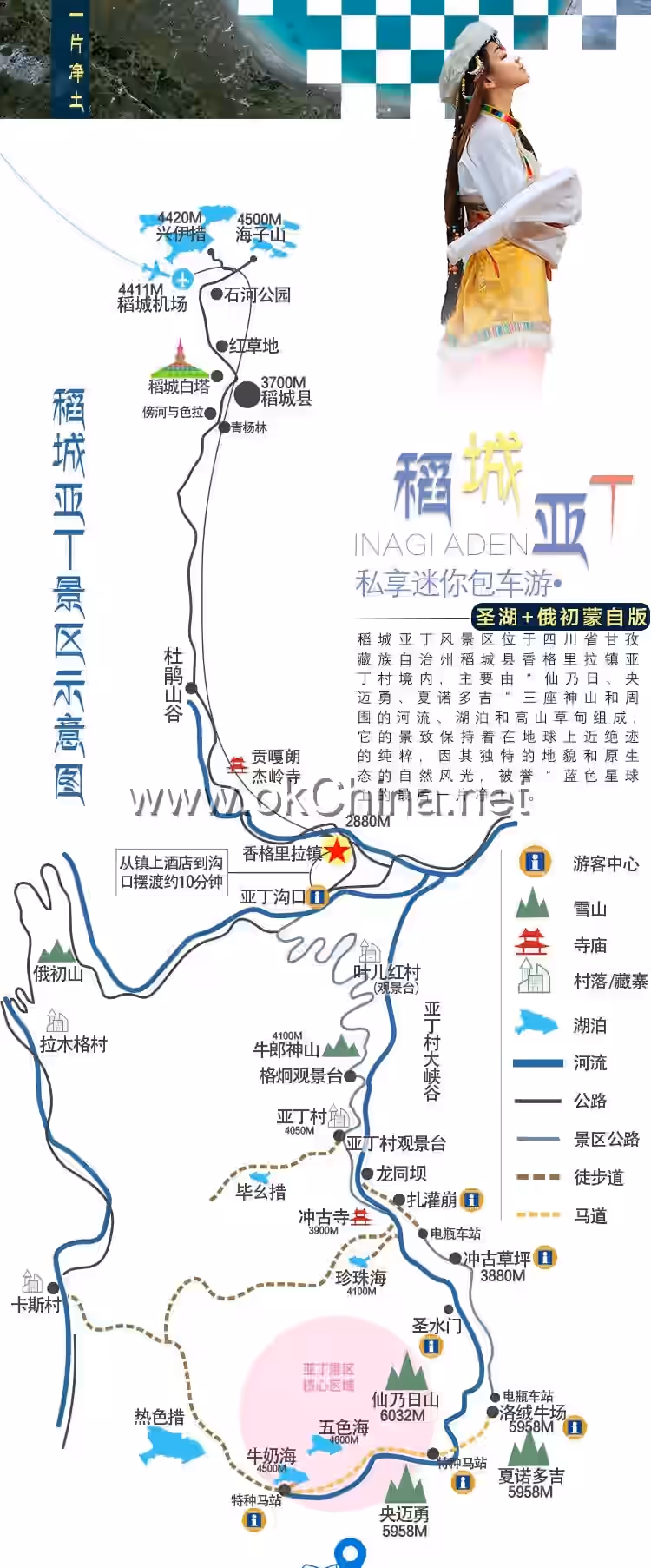
The Daocheng Yading Scenic Area is located in Yading Village, Xianggelila Town, Daocheng County, Ganzi Tibetan Autonomous Prefecture, Sichuan Province. It is approximately 82 kilometers from Daocheng County town, about 222 kilometers from Shangri-La City, and roughly 500 kilometers from Kangding City, the prefectural capital.
2.2 Topography and Landforms
The northern part of the Daocheng Yading Scenic Area features typical hummocky plateau terrain. The central part belongs to a mountain plateau landform region, while the southern part is an alpine gorge area. The topography is complex, with higher elevations in the northwest and lower in the southeast, characterized by undulating mountains and overlapping ridges.
2.3 Climate Characteristics
The Daocheng Yading Scenic Area experiences a continental monsoon plateau climate. Winters are long and summers are short, with significant temperature differences between day and night. The annual average temperature is 12.3°C. The rainy season occurs in July and August. Areas below 5,000 meters primarily receive rainfall, while extreme high-altitude areas above 5,000 meters primarily receive snow or hail.
3. Main Attractions
Overall Layout The main landscape of the Daocheng Yading Scenic Area consists of the three snow-capped mountains: Xiannairi, Yangmaiyong, and Xianuoduojie. These three mountains are distributed in a north-south direction, arranged in a triangular formation. According to the "Records of the Sacred Mountains," in the 8th century, the great master Padmasambhava traveled here and consecrated the three mountains as the embodiments of the three principal deities of Tibetan Buddhist Vajrayana: Avalokiteshvara (Guanyin), Manjushri, and Vajrapani, naming them the "Three Patron Saints Snow Mountains." They are sacred mountains perfectly combining "compassion," "wisdom," and "power." Based on practical considerations, the scenic area offers three tourist routes: the "Avalokiteshvara Compassion Line," the "Manjushri Wisdom Line," and the "Vajrapani Challenge Line."
3.1 Avalokiteshvara Compassion Line
3.1.1 Zhaguabeng
Zhaguabeng is the disembarkation point for sightseeing buses (coaches). In Tibetan, "Zha" means cliff or rock, "Gua" means a place for secluded practice, and "Beng" means grassland or meadow. Therefore, Zhaguabeng means "a place for practice on the cliff." Caves in the cliffs of Zhaguabeng have often been used by high lamas for retreats.
3.1.2 Three Sacred Mountains Thangka Mural
The Three Sacred Mountains Thangka Mural is a thangka painting carved onto a millennia-old glacial stone. Thangka is a unique form of painting art in Tibetan culture, distinguished by distinct ethnic characteristics, rich religious colors, and a unique artistic style. It uses bright colors to depict the Buddha realms of the three sacred mountains.
3.1.3 Living Buddha Stupa
The Living Buddha Stupa is a tall mani stone pile. Legend has it that when the Living Buddha Rangjang Genchug Gyatso came here to practice and propagate Buddhism, he received a dream from the sacred mountain Xiannairi instructing him to build a temple. However, building the temple angered the deities of the five elements, causing local people to fall ill. Living Buddha Rangjang transferred their illnesses onto himself, fell ill, and passed away. He instructed his followers to bury his true-body relics upside down (head down, feet up), after which the diseases disappeared. Local people built this stupa in memory of Living Buddha Rangjang, so future generations would remember his merits for eternity.
3.1.4 Water-Powered Prayer Wheel
Prayer wheels, also known as "mani" wheels, can be powered by water or wind energy, hence called water-powered or wind-powered prayer wheels. Tibetan people place scriptures inside the wheels; each rotation is equivalent to reciting the scriptures once.
3.1.5 Chonggu Monastery
Chonggu Monastery, meaning "temple built by filling a lake" in Tibetan, is a sub-temple of Gongga Langjiling Monastery and belongs to the Gelug school (Yellow Hat sect) of Tibetan Buddhism. Legend says Living Buddha Rangjang Genchug Gyatso received a dream from the sacred mountain Xiannairi (Avalokiteshvara) instructing him to build a temple. The Living Buddha summoned a divine crow and had it circle while holding prayer beads in its beak. The spot where the beads fell would be the temple site. For three days, the divine crow dropped the beads three times into the same lake at the foot of the Xiannairi sacred mountain. Thus, the lake was filled to build the temple. In the 17th year of the Republic of China (1928), the explorer and botanist Joseph Rock came to Yading and stayed at Chonggu Monastery. Currently, the main hall of the temple enshrines Tsongkhapa, the founder of the Gelug school of Tibetan Buddhism, along with Sakyamuni Buddha, Avalokiteshvara, Manjushri, Vajrapani, and others.
3.1.6 Pearl Lake
Pearl Lake is a seasonal alpine lake. During the summer rainy season, it sparkles with ripples and serves as the "dressing mirror" for the sacred mountain Xiannairi. In winter, Pearl Lake becomes a silvery-white sandy beach, resembling a pearl inlaid at the foot of Xiannairi.
3.1.7 Xiannairi Viewing Platform
The Xiannairi Viewing Platform is the closest viewing platform to the sacred mountain Xiannairi and is the best spot for close-up photography.
3.1.8 Zhuomala Cuo
Zhuomala Cuo is a lake formed by meltwater from the sacred mountains. Translated from Tibetan as "Tara Lake," it is said to be the soul lake of the Green Tara in front of the sacred mountain Xiannairi, possessing inconceivable and extraordinary power. Local people have a rule: one must not speak loudly, shout, or cough here. Otherwise, even a slight disturbance can cause wind, while a larger one can bring blizzards. This legend adds to the mystique of Zhuomala Cuo. Like a piece of exquisitely carved natural jadeite quietly inlaid between heaven and earth, the scenery here is absolutely stunning. It is the top choice for photography enthusiasts and the best location to capture the reflection of the sacred mountain Xiannairi in the lake.
3.1.9 Xiannairi Worship Platform
Local people have a traditional custom of circumambulating the "Three Patron Saints" sacred mountains. This spot is a necessary stop on the pilgrimage around Xiannairi, where people worship the mountain and pray for peace, health, and auspiciousness.
3.1.10 Millennial Mani Stone Pile
The Millennial Mani Stone Pile consists of 108 mani stone piles of varying sizes surrounding Chonggu Monastery. It is a place for prayer. The stones are called "mani stones" because they are carved with the six-syllable mantra. "Mani" comes from the abbreviation of the Sanskrit Buddhist scripture's six-syllable mantra—"Om Mani Padme Hum." The great mantra "Om Mani Padme Hum" is the heart mantra of the great compassionate Avalokiteshvara, symbolizing the Bodhisattva's compassion.
3.1.11 Chonggu Meadow
Chonggu Meadow is known as the "natural bonsai garden." It was once a glacial barrier lake. Later, a massive flood from an upstream lake breach destroyed the dam of this lake, turning it into the present-day meadow. This location was a primary filming site for the movie "I Belonged to You." It is a place for making promises, experiencing romance, and witnessing love.
3.2 Manjushri Wisdom Line
3.2.1 Celestial Musicians
The forest of ice horns and peaks represents numerous celestial musicians. Legend says they play heavenly music that reaches the Kasi Hell Valley behind Xiannairi. The sinners in hell, upon hearing this divine melody, find their suffering alleviated. Gently guided, they can repent sincerely and escape the sea of suffering sooner.
3.2.2 Holy Water Gate
The Holy Water Gate is a rock formation on a cliff that resembles a Tibetan-style gate. It is said to be the gate to the kingdom of "Shambhala." Legend has it that every year on the 15th day of the fourth Tibetan month, milky-white holy water gushes forth from the gate.
3.2.3 Sixteen Arhats
The Sixteen Arhats are a typical Danxia landform. They are sixteen naturally formed stone figures of varying sizes standing among the mountains, resembling the incarnations of the "Sixteen Arhats." Legend says the Sixteen Arhats, entrusted by Sakyamuni Buddha, remain in the human world without entering nirvana, free from the cycle of birth and death, serving as fields of merit for all beings and receiving offerings from them.
3.2.4 Luorong Pasture
The name "Luorong Pasture" originates from a person's name. Legend tells of a family named Luorong who herded livestock here, living an idyllic life. The area was later named Luorong Pasture. This is a vast grassland, considered the "heart" of the Three Patron Saints sacred mountains. Here, one can worship all three sacred mountains simultaneously.
3.2.5 Bulu God of Wealth Mountain
This pyramid-shaped sacred mountain has a gray-green body. Calling it the God of Wealth Mountain signifies its ability to bring good luck and wealth to people. According to Buddhist scriptures, it presides over wealth and can help all beings escape poverty and achieve prosperity.
3.2.6 Yangmaiyong Worship Platform
The Yangmaiyong Worship Platform is a place for worshipping the sacred mountain Yangmaiyong. Pilgrims circumambulating the mountains stop here to worship Yangmaiyong with devout hearts, seeking wisdom.#### 3.2.7 Blue Sheep/Tibetan Eared Pheasant Viewing
Along the loop trail, one can get close to the snow mountain spirits—the Blue Sheep and the Tibetan Eared Pheasant (both are National Second-Class Protected Animals), enjoying beautiful moments of harmonious coexistence between humans and nature.
3.2.8 Gongga Tso
In Tibetan, "Gongga" means snow mountain, and "Tso" means lake—a lake beneath the snow mountains. This is the best location to photograph the reflection of the sacred Mount Yangmaiyong.
3.3 Vajra Challenge Trail
3.3.1 Sheshen Cliff (Self-Sacrifice Cliff)
"Sheshen Cliff" is named after a legendary tale. It is said that a practitioner and a hunter lived next to each other here. The hunter shared his daily catch with the practitioner. One day, seeing a large pile of bones at the entrance of the practitioner's cave, the hunter felt deeply sinful. He leaped from the cliff with his two hunting dogs and, upon sudden enlightenment, ascended to heaven. Witnessing this, the practitioner thought that if a killer could attain enlightenment, so could he, and jumped as well, but was dashed to pieces. The cliff face of Sheshen Cliff is sheer and majestic, as if carved by axes, presenting a spectacular sight.
3.3.2 Milk Lake
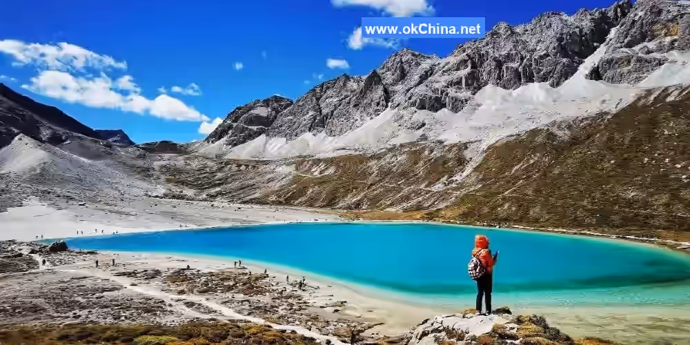
Milk Lake, known in Tibetan as "Erong Tso," is situated at an altitude of 4,500 meters and covers an area of approximately 5,000 square meters. The deep blue lake is edged with a milky-white ring of water, beyond which lie lush alpine meadows, sharply defined limestone mountains, and snow-capped peaks piercing the sky. Although named for the outermost milky ring, Milk Lake resembles the celestial eye of Gonggarisong Gongbu—so pure, so profound, and so captivating. Glacial erosion has created countless wonders across the Hengduan Mountains, and Milk Lake is one of its masterpieces.
3.3.3 Five-Color Lake
Five-Color Lake, also known as "Danzeng Tso," is located at an altitude of 4,700 meters and covers an area of about 5,800 square meters. The lake water becomes exceptionally clear after the deposition of calcium carbonate. The minimal impurities in the water allow short-wavelength light from the spectrum to be better absorbed, while the green, blue, and purple wavelengths reflected off the lake surface create a stunning visual impact that enchants viewers. Danzeng Tso is as famous as Tibet's Yamdrok Lake and is said to be able to "reflect history and foretell the future."
4. Cultural Resources
4.1 Origin of the Name
According to the "Daocheng County Annals," Daocheng was anciently named "Daoba," a transliteration from Tibetan meaning "open land at a mountain pass." In the 33rd year of the Guangxu reign of the Qing Dynasty (1907), rice cultivation was attempted here. To wish for its success, the name was changed to "Daocheng" (literally "Rice Success"). In the 28th year of the Republic of China (1939), it was renamed "Daocheng." Although differing by only one character, "Daocheng" and "Daoba" have vastly different meanings. The former is a Chinese place name, while the latter is the local Tibetan name. Several years ago, there was a proposal to rename Daocheng County to "Yading County," but it was eventually dropped. Daocheng has not been established as a county for long, and its history is not particularly illustrious even in the development of Tibetan regions, making its current fame somewhat disproportionate. Before Yading was "discovered," few people knew of Daocheng.
4.2 Folk Customs
4.2.1 Tibetan Buddhist Culture
In the Daocheng Yading area, Tibetans practice Tibetan Buddhism. Tibetan Buddhism, also known as the Tibetan Buddhist tradition or colloquially as Lamaism, refers to the branch of Buddhism that spread to Tibet, China, and belongs to the Mahayana tradition. Its origins can be traced back over 1,800 years.
Here, the entire Tibetan population is religious, with numerous sects. Besides the primitive Bon religion, there are several schools of Tibetan Buddhism, including the Nyingma (Red Sect), Gelug (Yellow Sect), Kagyu (White Sect), Kadam, and Sakya (Variegated Sect).
To this day, Tibetans maintain many unique Tibetan Buddhist祈福 (blessing) practices: circumambulating sacred mountains, worshipping sacred lakes, scattering wind horse flags, hanging colorful prayer flags, carving stone scriptures, building mani stone mounds, divination, offering torma (ritual cakes), butter sculptures, and using prayer wheels.
4.2.2 Tibetan Song and Dance Culture
Tibetan opera, known in Tibetan as "Ache Lhamo," means "fairy sisters." It originated from Tibetan religious art in the 8th century. By the 17th century, it had separated from monastic religious rituals and gradually evolved into a performance art centered on singing, combining singing, recitation, dance, acting, dialogue, and skills into a life-oriented performance. On May 20, 2006, Tibetan opera was approved by the State Council and included in the first batch of National Intangible Cultural Heritage lists.
Guozhuang dance, also known as "Guozhuo," "Gezhuang," or "Zhuo" in Tibetan, means circle song and dance. It is one of the three major folk dances of the Tibetan people and an ancient dance form that has been refined and enriched alongside the development of Tibetan production and life. As a folk dance, it possesses self-entertainment value and strong technical skill. On May 20, 2006, Guozhuang dance was approved by the State Council and included in the first batch of National Intangible Cultural Heritage lists.
Xianzi dance is an indispensable self-entertainment song and dance in Tibetan people's lives. During festivals, weddings, and gatherings, people come together joyfully, dancing in a circle. The lead dancer sings and dances while playing the xianzi (a Tibetan bowed string instrument) for accompaniment, with others following. Dancers sometimes gather towards the center of the circle and sometimes spread out, swinging their long sleeves gracefully. On May 20, 2006, Xianzi dance was approved by the State Council and included in the first batch of National Intangible Cultural Heritage lists.
4.2.3 Tibetan Characteristics
Tibetan clothing is distinctive. Both men's and women's Tibetan robes are large-fronted garments. Men's robes are typically made of black or white pulu (a woolen fabric), with collars, cuffs, fronts, and hems trimmed with colored cloth or silk. Women's Tibetan robes are mostly made of pulu, woolen fabric, or tweed. In summer and autumn, they wear sleeveless robes over brightly colored blouses in floral, red, or green patterns. Winter robes for women usually have sleeves. They are tied at the waist with silk sashes in red, lavender, green, or other colors. Tibetan women particularly love wearing aprons. The apron, called "bangdian" in Tibetan, is a special feature of Tibetan women's attire. Woven with unique techniques, they are intricate, elegant, and brightly colored. Moreover, the Tibetan robe itself is a古朴典雅 (simple and elegant) ornament and can be used as stage costume.
Tibetan-style dwellings in Daocheng are highly evocative, both in terms of architectural technique and artistic effect. The villages scattered across deep valleys, forests, and mountain plains form another scenic line in Daocheng. These dwellings, nestled against mountains or beside water, are structured and arranged in orderly tiers following the mountain contours. Whether stone-built Tibetan houses, black tents, or simple cattle sheds, they all embody a harmonious beauty with nature. Daocheng's complex geographical and geological environment determines the varied building materials and styles of its dwellings, showcasing the builders' ingenuity in using local resources. The附属装饰 (auxiliary decorations) of the houses reflect the owners' beliefs and traditions, developing a unique architectural style.
Axi black pottery is a type of black pottery ware with strong ethnic characteristics, rich cultural connotations, high practicality, and观赏性 (ornamental value). It is both a National Intangible Cultural Heritage item, a unique Tibetan handicraft product, and one of the "Four Wonders" of Daocheng Yading. In Chitu Township of Daocheng County, there is a long red soil layer, from which the township gets its name "Chitu" (Red Earth). This red soil has a special composition, containing alumina and trace elements, with strong粘性 (adhesiveness) and good透气性 (breathability), making it an excellent material for pottery. The people of nearby Axi Village have used this soil to make pottery since ancient times. Over thousands of years of development and传承 (inheritance), a perfect and unique black pottery firing technique has been formed in Axi, producing generations of skilled artisans.
Presenting a khata (ceremonial scarf) is the most common etiquette among the people of Daocheng, often used in welcomes, gift-giving, worship, and daily interactions to show respect and congratulations.
The etiquette of kowtowing is mainly seen in temples. When making pilgrimages to temples or meeting high lamas, believers kowtow to show loyalty and devotion.
The etiquettes of敬酒 (toasting) and敬茶 (offering tea) are commonly observed by the Tibetan people of Daocheng when receiving relatives and friends. Most of the淳朴 (simple and honest) Tibetan people are warm, sincere, and very hospitable.
Comments
Post a Comment