Changbai Mountain
1. Introduction
The Changbai Mountain Scenic Area in Yanbian Korean Autonomous Prefecture is located in the Chibei District, Erdaobaihe Town, Antu County, Yanbian Korean Autonomous Prefecture, in the southeast of Jilin Province. Its geographical coordinates are between 127°42'55" to 128°16'48" east longitude and 41°41'49" to 42°51'18" north latitude, covering an area of 52.42 square kilometers. Changbai Mountain is the highest mountain range on the eastern edge of the Eurasian continent, situated near the border between China and North Korea.
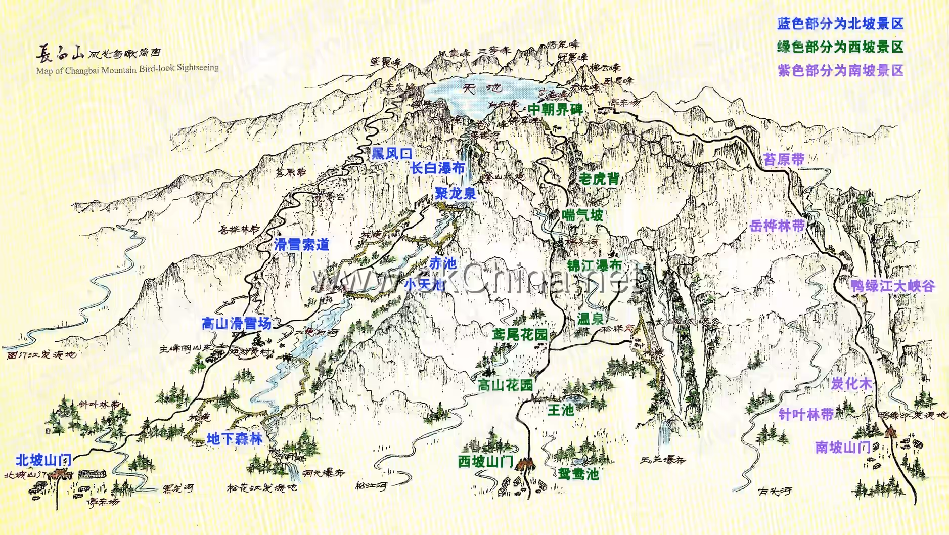
The Changbai Mountain Scenic Area in Yanbian Korean Autonomous Prefecture is divided into three major scenic areas: West, North, and South. Its main attractions include the Sixteen Peaks of Changbai Mountain, Alpine Garden, Panting Slope, and other vertical vegetation landscapes and volcanic landforms. It is one of the first national natural heritage sites included in the "China National Natural Heritage and National Natural and Cultural Dual Heritage Preparatory List." It has been successively designated as one of the first national-level nature reserves, one of the first national 5A-level tourist attractions, a UNESCO "Man and the Biosphere" nature reserve, and an international A-level nature reserve.
Changbai Mountain, along with its Tianchi (Heavenly Lake), waterfalls, snow sculptures, and forest seas, has been repeatedly recognized in the Guinness World Records. It also holds honors such as one of China's Ten Famous Mountains, one of China's Five Most Beautiful Lakes, and one of China's Ten Most Beautiful Forests.
2. Historical Evolution
2.1 Ancient Times
The history of the Changbai Mountain Scenic Area in Yanbian Korean Autonomous Prefecture, as recorded in language and writing, can be traced back over 4,000 years. It is documented in China's earliest geographical work, Shan Hai Jing (Classic of Mountains and Seas), where Changbai Mountain is referred to as Buxian Mountain (the Mountain of Immortals).
2.2 Northern and Southern Dynasties
In other texts from the Northern and Southern Dynasties period (such as Wei Shu and Qi Shu), it is often called "Zongtai Mountain" or "Zongbai Mountain."
Later, records can be found in Tang Shu - Dongyi Liezhuan (Book of Tang - Biographies of Eastern Barbarians): "Mohe dwells in the land of Sushen, and the southernmost part of the Limo tribe reaches Taibai Mountain, also called Xitai Mountain, bordering Goguryeo."
Qidan Guo Zhi (Records of the Khitan State) notes: "Changbai Mountain is over a thousand li southeast of Leng Mountain, where all birds and beasts are white."
2.3 Jin Dynasty
Jin Shi (History of the Jin Dynasty) records: "The Jurchen land has Changbai Mountain."
The mid-Jin Dynasty literatus Zhao Bingwen (1159–1233, courtesy name Zhouchen) wrote the long poem Changbai Shan Xing (Journey to Changbai Mountain).
The Jurchen people of the Jin Dynasty regarded Changbai Mountain as their place of origin and frequently paid homage to it, praying for the prosperity and longevity of their state.
Shortly after ascending the throne, Emperor Shizong of Jin, Wanyan Yong, in the 12th year of the Dading era (1172), conferred the title "King of Xingguo Lingying" upon Changbai Mountain. He ordered the renowned scholar Dang Huaiying of the Hanlin Academy to compose the Feng Changbai Shan Wei Lingying Wang Ce Wen (Edict Conferring the Title of King of Lingying upon Changbai Mountain), which greatly mythologized the mountain. In the 15th year of Dading (1175), the emperor built the Lingying Wang Temple north of Changbai Mountain and ordered ministers to perform rituals and present the edict there. In the 25th year of Dading (1185), Emperor Shizong also conferred a title upon the Songhua River (then called the Huntong River), which originates from Changbai Mountain, and ordered ministers to write the Feng Huntong Jiang Shen Wei Yingsheng Gong Ce Wen (Edict Conferring the Title of Duke Yingsheng upon the Huntong River God), performing rituals accordingly. Emperor Shizong further deified Changbai Mountain and the Songhua River.
During the reign of Emperor Zhangzong of Jin, Wanyan Jing, in the 4th year of the Changming era (1193), Changbai Mountain was elevated to "Kaitian Hongsheng Emperor," a rank higher than the titles of king or duke conferred by his father, Emperor Shizong. This placed it on the same level as the Jade Emperor of heaven and the emperor on earth, positioning it as a sacred emperor in the founding and governance of the Jin Dynasty.
2.4 Yuan Dynasty
The Yuan Dynasty poet Wang Jie (courtesy name Yibo, from Dingxing, Hebei) also described Changbai Mountain in his long poem Liaodong Gao Jiefu (The Chaste Woman of Liaodong).
2.5 Ming and Qing Dynasties
In the 11th year of the Wanli era of the Ming Dynasty (1583), Nurhaci led his troops in an uprising. By the 17th year of the Chongzhen era (1644), he led the Eight Banners into the Central Plains and established the Qing Dynasty. Therefore, the Qing Dynasty always regarded Changbai Mountain as the sacred birthplace of their ancestors and honored it as the "God of Changbai Mountain."
Several Qing emperors, including Kangxi, Qianlong, and Jiaqing, personally traveled to the northeast to worship their ancestral homeland. They also wrote numerous poems and sacrificial texts praising and honoring Changbai Mountain. Kangxi wrote the poem Wang Si Changbai Shan (Gazing Upon and Sacrificing to Changbai Mountain) and two pieces of Ji Qian Changbai Wen (Texts for Sacrificing to Changbai Mountain). Qianlong composed five pieces of Ji Gao Changbai Shan Wen (Texts for Sacrificial Announcements to Changbai Mountain), and Jiaqing wrote two pieces of Changbai Shan Gao Ji Zhu Wen (Prayer Texts for Sacrificing to Changbai Mountain).
3. Geographical Environment
3.1 Geographical Location
The Changbai Mountain Scenic Area in Yanbian Korean Autonomous Prefecture is located in the southeast of Chibei District, Erdaobaihe Town, Antu County, Baishan City, Jilin Province. It borders North Korea to the southeast and is situated north of the Changbai Mountain range, 34 kilometers away from Changbai Mountain itself. The scenic area covers 52.42 square kilometers.
3.2 Topography and Landforms
The Changbai Mountain Scenic Area in Yanbian Korean Autonomous Prefecture lies on the edge of the East Asian continent, within the intense fold belt adjacent to the Pacific Ocean. Before the Mesozoic era, 200 to 75 million years ago, the area underwent multiple crustal movements, forming ancient rock strata. Over hundreds of millions of years of erosion during the Mesozoic, a series of intermountain basins formed. By the Cenozoic era, it had become a undulating peneplain with scattered residual hills. The scenic area features typical volcanic landforms. From bottom to top with increasing altitude, it consists mainly of three parts: basalt platforms, basalt plateaus, and volcanic cones. The broad basalt platforms and plateaus are crowned by the volcanic cone—the main peak of Changbai Mountain. The basalt plateau (also known as the piedmont sloping plateau) lies between the basalt platforms and the volcanic cone, forming a relatively distinct sloping zone with ground slopes generally around 10 degrees and elevations between approximately 1,000 and 1,800 meters. It serves as a transitional zone from the steep volcanic cone to the basalt platforms.
3.3 Regional Scope
The regional scope of Changbai Mountain has different meanings in regional geography and practical applications.
In a narrow sense, Changbai Mountain refers to the main peak of the Changbai Mountain range, i.e., the giant volcanic cone above 1,800 meters in elevation. Another interpretation refers to the Changbai Mountain volcanic zone, including the volcanic cone and the extensive Changbai Mountain lava platforms. Its scope roughly extends north to Songjiang Town in Antu County, Jilin Province; west to Fusong County, Jilin Province; and south and east to the Sino-North Korean border, connecting with the mountainous terrain within North Korea.
In a broad sense, Changbai Mountain refers to the Changbai Mountain range, or Changbai mountainous region, which is the general term for the eastern mountainous area of Northeast China. Its scope extends north to the southern edge of the Sanjiang Plain in Heilongjiang Province; west to the eastern edge of the Songliao Plain; south to the southern tip of the Liaodong Peninsula; and east to the Sino-Russian border, with the eastern and southern parts reaching the Sino-North Korean border. The Changbai Mountain range is approximately 1,300 kilometers long from north to south and about 400 kilometers wide from east to west, roughly spindle-shaped. The main body of the Changbai mountainous region runs northeast-southwest, consisting of a series of parallel northeast-southwest trending mountain ranges and several northwest and east-west trending ranges. Major ranges include the Wanda Mountain (Nadanhada Ridge), Daqing Mountain, Dahei Mountain, Zhangguangcai Range, Laoye Range, Taiping Range (Muling Waji Ridge), Jilin Hada Range, Longgang Mountain, Harba Range, Mudan Range, Nangang Mountain, Lao Range, Laosong Range, Changbai Mountain, and Qian Mountain. Some mountains in the east and south connect with ranges in Russia and North Korea.
3.4 Formation and Evolution
Approximately 4.5 billion years ago, when the Earth was basically formed, a gap appeared at a point in the Eastern Hemisphere. This gap is the entire Changbai Mountain region.
Over about 25 million years, the Changbai Mountain region experienced four volcanic eruption events. Basaltic magma rose from the upper mantle along major fissures in the Earth's crust and erupted onto the surface with tremendous energy. The magma, carrying powerful impact force, ejected original rocks, previously solidified rock blocks from the magma, volcanic ash, and water vapor into the air. These materials then fell around or to one side of the volcanic vent under gravity and wind, accumulating into various volcanic landforms. Due to the relatively low viscosity of basaltic magma, it flowed quickly on the surface and covered long distances, forming extensive basalt platforms. The Nangang Mountain range, Changhong Ridge, Yingbi Mountain, and other basalt platforms that form the foundation of the main peak of Changbai Mountain, distributed along the northwest direction, were formed during this period.
Before the volcanic eruptions, the surface of the Changbai Mountain area was relatively flat. Approximately 2.77 million years ago, centered on Changbai Mountain, significant fissures appeared in the Earth's crust, leading to the earliest volcanic eruptions and the formation of basalt lava platforms—the Changbai Mountain Lava Platform and the Baimao Lava Platform. The lava thickness ranged from 50 to 300 meters, covering an area of 15,000 square kilometers. At that time, Changbai Mountain, due to its lava vents, stood at the top of a shield-like platform higher than the surrounding areas. Later, volcanic activity ceased for a period. About 580,000 years ago, a second volcanic eruption occurred, depositing more viscous alkaline trachyte near the center of Changbai Mountain, with a total rock layer thickness exceeding 896.78 meters. Approximately 440,000 years ago, a third volcanic eruption, also involving viscous alkaline trachyte, occurred, making it difficult for the material to travel far. It only accumulated on the existing trachyte, adding a thickness of 111 meters. About 210,000 years ago, a fourth volcanic eruption took place, again depositing alkaline trachyte with a thickness of 196 meters. At the end of that volcanic activity, Tianchi (Heavenly Lake) formed through volcanic crater subsidence.
During the period from about 600,000 to 15 million years ago (mid to late Quaternary Pleistocene), the Changbai Mountain region experienced another phase of crustal activity, geologically referred to as the Baitoushan period. During this period, four volcanic eruptions occurred, characterized by central-type eruptions. Underground magma rose along cylindrical channels formed at the intersections of deep faults, creating volcanic cone landforms on the surface.The volcanic ejecta from the first eruption, which occurred approximately 600,000 years ago, formed the base of the Changbai Mountain volcanic cone. The second eruption took place around 400,000 to 300,000 years ago; this eruption lasted for an extended period, resulting in widespread and thick volcanic rock layers. The third eruption occurred about 200,000 to 100,000 years ago, ultimately shaping the form of the Changbai Mountain volcanic cone. The fourth eruption, around 80,000 years ago, was primarily characterized by small-scale volcanic activity, with lava flows covering certain parts of the volcanic cone. By this time, the main peak of Changbai Mountain had taken shape.
During these four volcanic activities, each eruption added over 200 meters to the height of the volcano. Additionally, several smaller parasitic craters formed around the main crater. Following this, Changbai Mountain entered a period of relative stability.
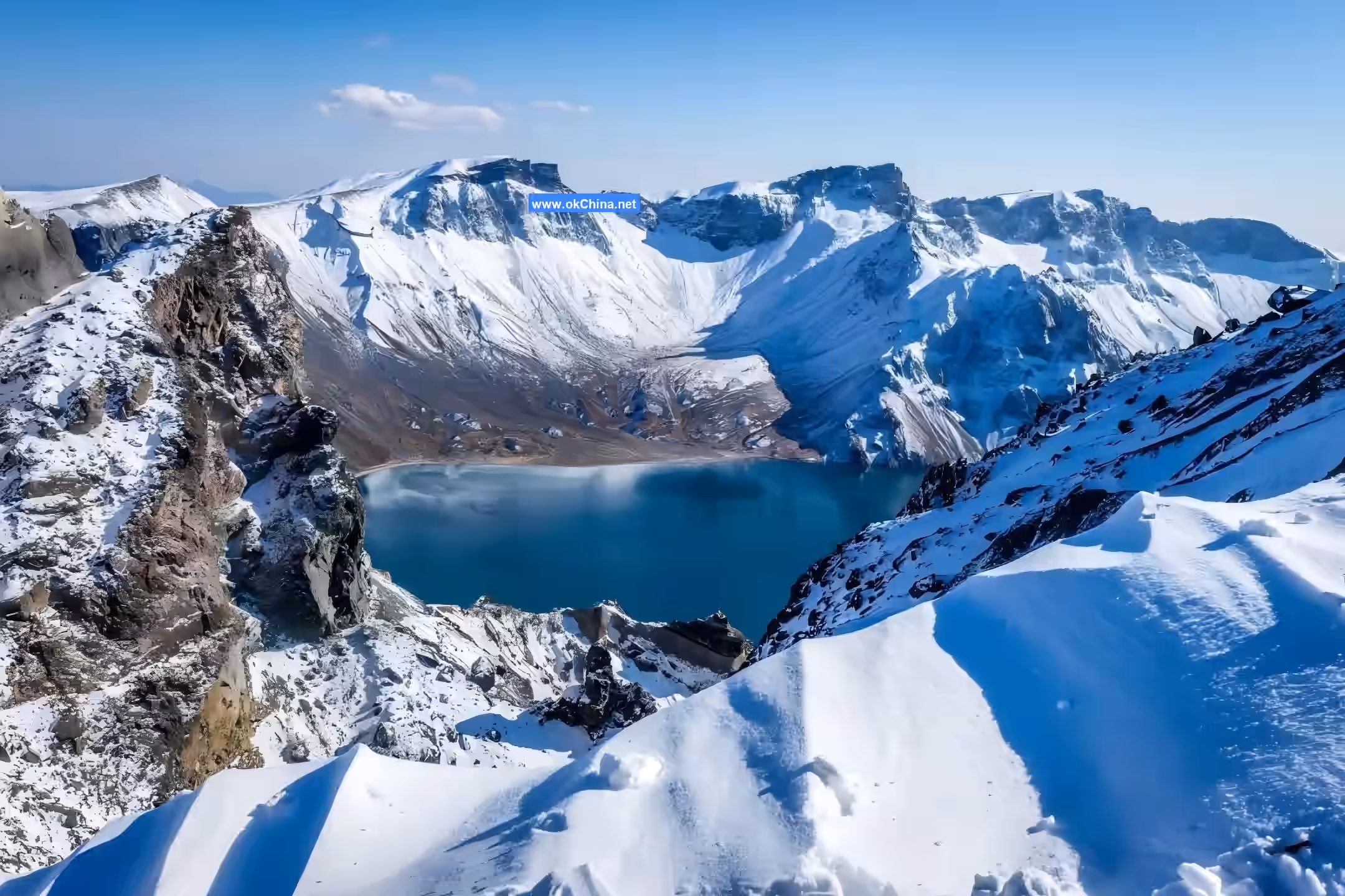
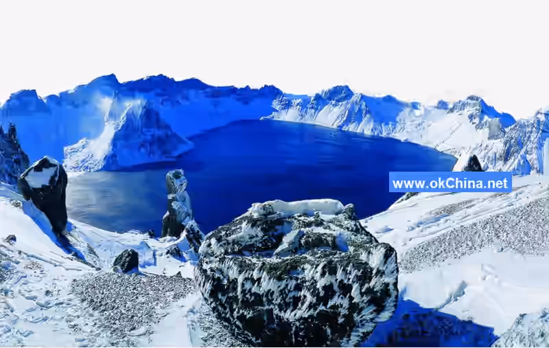
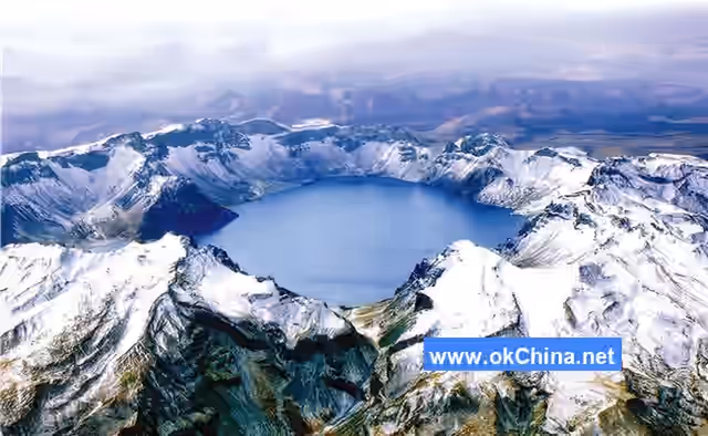
Between 11,000 and 15,000 years ago (during the Holocene epoch of the Quaternary period), the volcano reactivated, ejecting large quantities of grayish-white to pale-yellow pumice, with local thickness reaching up to 60 meters. This violent eruption caused the top of the volcanic cone to collapse, forming a funnel-shaped crater. As the intensity of the eruption and the temperature of the lava gradually decreased, the magma cooled and solidified within the volcanic conduit, eventually blocking it. After volcanic activity ceased, atmospheric precipitation and groundwater continuously replenished the crater, gradually accumulating water to form a crater lake. This is the origin of Tianchi (Heavenly Lake) on Changbai Mountain.
After the main body of Changbai Mountain was formed, the region entered an intermission period of volcanic eruptions, with relatively stable crustal movements. However, in the long river of geological history (the Earth formed at least 4.6 billion years ago, and the crustal evolution of the Changbai Mountain area spans about 3.2 billion years), the geological evolution of Changbai Mountain is but a brief moment. The history of volcanic eruptions at Changbai Mountain is even shorter, yet it is not extinct; it is merely in a dormant state, classified as a dormant volcano.
4. Main Attractions
4.1 Western Scenic Area
4.1.1 Alpine Garden
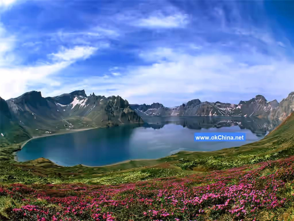
The Alpine Garden is one of the most famous attractions in the Changbai Mountain scenic area of Yanbian Korean Autonomous Prefecture. Located at an altitude of about 1,400 meters in the western scenic area, it features a temperate mountain climate. The flowers here are densely concentrated and cover a large area, distributed across slopes, under forests, valleys, and along rivers. Among them, irises, lilies, daylilies, globeflowers, meadow-rues, and false hellebores are the most renowned. Every year at the transition between spring and summer, various wildflowers bloom in competition, earning it the title "Ten-Thousand-Mu Grand Garden." By July, lilies, daylilies, irises, and stream orchids are in full bloom.
4.1.2 Panting Slope
Panting Slope is steep with a significant gradient, featuring a continuous uphill path at an angle of over 70 degrees. There is only one narrow trail leading directly to the top, requiring visitors to climb continuously. Additionally, due to the altitude ranging from 1,800 to 2,000 meters, where the air is thin, climbers inevitably pant heavily, hence the name "Panting Slope." Interestingly, at this altitude, which is typically the Erman's birch forest zone, only Erman's birch should grow, yet spruce, fir, and larch are found here. This is because the slope faces the sun, receiving ample sunlight and creating a mild microclimate.
4.1.3 Golden Thread Spring
Golden Thread Spring is located at the eastern foot of Yuzhu Peak, on the western shore near Tianchi. The spring water flows out from between two stone pillars, north and south, resembling silk threads that glisten under sunlight like golden threads. Liu Jianfeng, who conducted the earliest comprehensive scientific survey of Changbai Mountain, said, "Viewed closely, the water reveals golden stars," hence the name. Golden Thread Spring is a seasonal spring; "in autumn and winter, it is covered by snow without a trace; in summer, it meanders affectionately, enviable to behold. The water thread extends over five li." (Liu Jianfeng). Legend has it that in the spring resides Changbai Mountain's rain official—a double-headed snake. This snake has wings, and whenever it flaps them to fly high, heavy rain falls on Changbai Mountain.
4.1.4 Mandarin Duck Ponds
Mandarin Duck Ponds are located deep in the forests of Changbai Mountain's western slope. There are two explanations for the name: First, it is a paradise for wild birds, with flocks of waterfowl inhabiting it during spring, summer, and autumn, especially many mandarin ducks. Second, there are two similar ponds connected together, inseparable like a pair, resembling mandarin ducks, hence the name. In fact, combining both reasons is accurate. Mandarin Duck Ponds indeed consist of two small lakes together, with many waterbirds in the lakes. The ponds were formed after volcanic eruptions, with clear, unpolluted water visible to the bottom.
4.1.5 Jade Nectar Spring
Jade Nectar Spring is located on the western slope of Changbai Mountain by Tianchi, east of Yuzhu Peak, about 350 meters from Tianchi. The spring water gushes out from cracks in the mountain rocks, soon disappearing into the rock crevices to become a hidden spring, re-emerging about 20 meters from Tianchi before flowing into the lake. Liu Jianfeng once surveyed Jade Nectar Spring on-site. He said, "Jade Nectar Spring is about six steps southwest of Tianchi, flowing into Tianchi. The water is clear, the sand bright, pure and delightful, hence the name." Liu Jianfeng also noted, "I first drank from Tianchi, then tasted the spring water; their flavors are equally sweet and clean." The poem "Ode to White Mountain" says: "If you gentlemen reach Tianchi, you must fill silver pots with jade nectar," referring to this spring.
4.1.6 Jinjiang Waterfall
Jinjiang Waterfall is located on the upper reaches of Jinjiang River, 8 kilometers southwest of Wohu Peak on the western foothills of Changbai Mountain in Jilin. Because it is in the middle of Tizi River, it is also called Tihe Waterfall. Jinjiang Waterfall is a two-tiered waterfall with a total drop of 73 meters, over 5 meters higher than Changbai Waterfall on the northern foothills. The first tier is 50 meters, the second 20 meters, totaling 70 meters. This stepped waterfall, also known as a double-drop waterfall, is a major landscape on Changbai Mountain's western slope. Below the waterfall, the banks of Jinjiang River are cliffs over 60 meters high. Jinjiang Waterfall flows year-round, with good vegetation around it. The steep banks on both sides of the river channel are covered with peculiar pines and rocks, and giant fallen trees span the channel, forming natural bridges. Along the walking path from the main entrance to Jinjiang Waterfall, scattered individual or clusters of Erman's birch forests dot the area. In summer, the undulating highland meadows are adorned with blooming mountain flowers.
4.1.7 Sixteen Peaks of Changbai Mountain
In ancient times, none of the peaks had formal names; often, local villagers gave them highly rustic names based on their shapes, such as "Eagle Beak Cliff." In the 34th year of the Guangxu reign of the Qing Dynasty (1908), Liu Jianfeng, a late Qing scholar and candidate magistrate of Fengtian, was ordered to survey Changbai Mountain. After four months of on-site investigation, besides official reports like "Investigation of the Three River Sources of Changbai Mountain," he also wrote "Records of Changbai Mountain Rivers and Ridges." Liu Jianfeng was both a scholar and a poet, often composing poems and naming the peaks. The opening of "Records of Changbai Mountain Rivers and Ridges" names the extraordinary peaks of Changbai Mountain: "Changbai Mountain, the ancient Buxian Mountain... In its center lies Tianchi, surrounded by many extraordinary peaks. The major ones are six: Baiyun, Guanmian, Baitou, Sanqi, Tianhuo, and Zhipan. The minor ones are ten: Yuzhu, Tiyun, Wohu, Gusun, Zixia, Huagai, Tiebi, Longmen, Guanri, and Jinping." He also drew detailed topographic maps marking the locations of the sixteen peaks. After the Changbai Mountain Nature Reserve was established in 1960, some people altered the names Liu Jianfeng gave to the sixteen peaks for inexplicable reasons, changing the original names to confusing ones, causing great trouble for later generations. To this day, many people often confuse the peak names. Ancient literati, modern writers and poets, as well as many ordinary people and contemporary experts from "Place Name Offices," have actively participated in discussions. Based on historical materials such as "Records of Changbai Mountain Rivers and Ridges," "Antu County Chronicles," "Fusong County Chronicles," and later descriptions and the actual shapes of the mountains, the origins of the peak names are summarized below.
Baiyun Peak
Baiyun Peak is located on the west side of Tianchi, in the southeast of Fusong County, Baishan City, adjacent to Yuzhu Peak to the south and facing Zhipan Peak to the north. With an altitude of 2,691 meters, it is the highest peak in Northeast China. According to "Antu County Chronicles": "Baiyun Peak is at the summit of White Mountain. Viewed from afar, the peak pierces the heavens, with clouds touching it and lingering all day. On clear days, all peaks are visible, but this peak alone is shrouded in mist, majestic in appearance. From Tianchi to the summit is ten li; towering mountains hide the sky, clouds lock the peak, hence named Baiyun Peak." "Records of Changbai Mountain Rivers and Ridges" notes: "This peak is the highest in Changbai Mountain; ascending from behind the ridge to the east, it can be seen from two hundred li away, often veiled by white clouds." "Past and Present Scenic Spots of Changbai Mountain" states that from a distance, Baiyun Peak remains hidden in swirling clouds all day, as if in deep thought or meditation, silent and shy to show itself. Occasionally, under clear skies with light clouds and gentle winds, all peaks reveal themselves, each displaying its charm, yet Baiyun Peak still borrows patches of white clouds as a veil to cover its face. The poem "Ode to White Mountain" says: "After viewing and turning back to look, White Mountain remains sealed by white clouds." On July 26, 1984, Peng Zhen, Chairman of the Standing Committee of the National People's Congress, visited Changbai Mountain and vigorously inscribed the three characters "Baiyun Peak."
Zhipan Peak
Zhipan Peak, also known as Luming Peak, is located slightly northwest of Tianchi, with an altitude of 2,603 meters. The summit consists of four small peaks, giving rise to the saying "four sons meet at Zhipan." The summit has a meadow shaped like a round plate. During severe winters, when other peaks are snow-capped, only this peak remains exposed. "Records of Changbai Mountain Rivers and Ridges" notes that local villagers say the summit produces lingzhi (glossy ganoderma), hence the name. Every summer, deer herds come here to escape the heat, creating the scene of "deer calling in green valleys, eagles flying over Zhipan." According to research by Liu Jianfeng's great-grandson Liu Zili, this peak was actually named by Liu Jianfeng to commemorate his hometown—"Zhipan Village" in Linwu Township, Zhucheng County, Shandong.
Jinping Peak
Jinping Peak, with an altitude of 2,590 meters, is located on the west side of Tianchi. According to "Records of Changbai Mountain Rivers and Ridges," Jinping Peak lies between Zhipan Peak and Guanri Peak, "resembling a screen." Hunters, seeing its shape like a city wall, habitually called it "City Wall Cliff."According to "The Past and Present Attractions of Changbai Mountain," "Peaks rise to the north and south of the summit, adorned with colorful jadeite stones at their crests. Steep cliffs stand before and behind the peaks, resembling an embroidered screen, hence the name."
Sunrise Peak
Sunrise Peak is located northwest of Heaven Lake at an altitude of 2,510 meters. "The Brief Records of Changbai Mountain's Rivers and Peaks" notes: "The peak rises to a sharp point; climbing it to look out, the sea is vast and the sky boundless, making it suitable for observing sunrise and sunset." Hence, it is named Sunrise Peak. The book also states: "Locals say that every year on the night of the third day of the third lunar month, if the weather is clear, the sun appears like a red ball emerging from the white sea. It rises and falls three times, with waves surging and rolling up and down, vividly visible. This is particularly captivating for viewers, evoking emotions akin to being at sea." To the north, ascend along the edge of the birch forest, follow the ridge, climb beside Hidden Stream Waterfall, pass behind Dragon Gate Peak, and reach the summit of Sunrise Peak. Sunrise Peak and the Western Slope; legend has it that herds of red deer often roam the mountain.
Dragon Gate Peak
Dragon Gate Peak, at an altitude of 2,595.7 meters, is located slightly northwest of Heaven Lake. Together with Tianhuo Peak, it guards the outlet of Heaven Lake's water. "The Brief Records of Changbai Mountain's Rivers and Peaks" records: "West of the Chengcha River, it faces Tianhuo Peak but is lower. The lake water overflows and flows out, taking the shape of a gate, hence the name Dragon Gate." Legend says that Yu the Great once visited this peak during his flood control efforts. Beside the mountain lies a stone with tadpole-like characters. In the hearts of the people, this stele is divine, and no one can decipher the tadpole script. It is said that someone once saw several red-yellow fish leaping in the Chengcha River in front of Dragon Gate Peak and threw stones at them. Unexpectedly, "suddenly, fierce winds arose, white rain poured down, thunder roared continuously, and the fish vanished."
Tianhuo Peak
Tianhuo Peak, at an altitude of 2,620 meters, is located on the east bank of the Chengcha River, facing Dragon Gate Peak. According to "The Brief Records of Changbai Mountain's Rivers and Peaks," "The peak rises with twin points, split by a line in the middle, creating a suddenly open and wondrously fascinating scene," hence the name Tianhuo Peak. "Legend says the mountain crevice was split by Yu the Great during his flood control efforts." The side of Tianhuo Peak facing Heaven Lake has "yellow soil, resembling two dragons coiled on the summit. The rocks behind the peak are mostly red, also quite pleasing to the eye. Every winter, snow congeals between the peaks, like a white rainbow piercing the Milky Way, making it exceptionally striking." According to locals, within the flat crevice at the peak, several cave openings are hidden. Climbers often see pythons appearing among them.
Iron Wall Peak
Iron Wall Peak is located on the north side of Heaven Lake at an altitude of 2,560 meters. According to "The Brief Records of Changbai Mountain's Rivers and Peaks," this peak has "black soil, resembling iron," hence the name. From here, overlooking Heaven Lake, the lake's shimmer and mountain scenery are fully visible, making it the second most spectacular spot on the north slope of Changbai Mountain to view Heaven Lake. It is said that a herb gatherer once came here and saw the peak adorned with lanterns and decorations, resplendent and magnificent, with countless red characters hanging in the middle, most of which were unrecognizable. Only the characters for "fortune" and "longevity" were neither seal nor clerical script, resembling birds and insects, and could still be discerned. Upon returning and telling others, everyone thought it absurd and did not believe him. When he went back to look again, he never saw such a scene.
Canopy Peak
Canopy Peak, also known as Yellow Rock Peak, Eagle Beak Peak, and Astronomical Peak, stands at an altitude of 2,670 meters. It is the third highest peak of Changbai Mountain and the highest peak on the east side of Heaven Lake. It represents the essence of Changbai Mountain and is the first most spectacular spot to overlook Heaven Lake from the north slope. On the east side of Canopy Peak is the "Wind-Sheltering Stone," where Liu Jianfeng took shelter from wind and rain during his survey of Changbai Mountain and left the ink inscription "Tianchi Diaowen visited here." On the west side are "Heaven Lake Pillar" and "Warship Rock." At the base of the peak by Heaven Lake, there are scenic spots such as the Jurchen Altar, Fishing Platform, Unicorn Ridge, and Phoenix Ridge. Canopy Peak has the most aliases among the sixteen peaks of Changbai Mountain. According to "The Brief Records of Changbai Mountain's Rivers and Peaks," Canopy Peak "has a mountain shape like a canopy, and its clouds emerge and return like a canopy. Every spring and winter, multicolored clouds often cover the summit, and even in wind and snow, they do not disperse." It is named "Canopy Peak" because it resembles the canopy of an imperial carriage. Because the peak is composed of yellow pumice, it is also called "Yellow Rock Peak." Because the peak is sharp like an eagle's beak, leaning toward Heaven Lake, some call it "Eagle Beak Peak." After the Changbai Mountain Heaven Lake Meteorological Station was built on its east side in 1958, people also began calling it Astronomical Peak. However, nowadays, some often mistakenly believe that Canopy and Astronomical are two different peaks. This misconception spreads erroneously and causes endless harm. In fact, when Liu Jianfeng named the sixteen peaks, only "Canopy Peak" existed, with no mention of "Astronomical Peak." It is only because Canopy Peak has two summits that later people referred to the summit directly facing the meteorological station as Astronomical Peak and the other as Canopy Peak.
Purple Mist Peak
Purple Mist Peak, at an altitude of 2,618 meters, is located on the east side of Heaven Lake. According to "The Brief Records of Changbai Mountain's Rivers and Peaks," it is described as having "purple sandy soil, with rocks scattered irregularly, full of vitality. Every evening, clouds emerge from the lake, entwining the peak like threads. Their swirling appearance resembles crimson clouds lingering in the sky." Hence, it is named Purple Mist Peak. Legend says, "The peak produces gemstones; from afar, they shine like bright stars."
Lone Falcon Peak
Lone Falcon Peak is located southeast of Heaven Lake, between Purple Mist Peak and Three Wonders Peak, at an altitude of 2,511 meters, now within North Korean territory. In "The Brief Records of Changbai Mountain's Rivers and Peaks," Liu Jianfeng describes it: "The peak is sharp, elegant, steep, and ancient, slanting southwest with strength, shaped like a lone falcon. Among the layered mountains, it stands uniquely, making viewers feel a sense of independence."
Three Wonders Peak
Three Wonders Peak is located southeast of Heaven Lake at an altitude of 2,670 meters, now within North Korean territory. According to "The Brief Records of Changbai Mountain's Rivers and Peaks," "Three peaks stand side by side, with rocks towering like precious stones, reflecting in Heaven Lake. Their beauty is palpable, as if the three immortal mountains of the sea remain in the human world." Hence, it is called Three Wonders Peak. It is said that there is a cave at the summit of Three Wonders Peak that leads directly to Heaven Lake.
White Head Peak
White Head Peak, at an altitude of 2,749 meters, is the highest among the sixteen peaks. According to "The Brief Records of Changbai Mountain's Rivers and Peaks," White Head Peak is located slightly east of south of Heaven Lake. "To the east, it rises high and full, with a solitary rock standing alone, shaped like a Buddha's head." Hence, it is named White Head Peak. Now within North Korean territory, it is called "General Peak" by the North Korean side.
Crown Peak
Crown Peak is located directly south of Heaven Lake at an altitude of 2,525.8 meters. It is a border peak between China and North Korea, facing "Sky-Mending Stone" across the lake. "The Brief Records of Changbai Mountain's Rivers and Peaks" states it has "layered ridges and peaks, dignified and solemn, with the shape of a crown, hence the name." This peak is also called "Jade Snow Peak," likely because from a distance, it appears white as snow all year round. In reality, the whiteness is not snow but jade-white pumice, though from afar, snow and rock are indistinguishable. However, on the side facing Moon Lake, there truly is much perennial snow, commonly called "Snow Mountain." Below are several ice caves, often emitting wisps of smoke, leading some to suspect immortals refining elixirs there.
Crouching Tiger Peak
Crouching Tiger Peak is located slightly west of south of Heaven Lake at an altitude of 2,566 meters, serving as a border peak between China and North Korea. According to "Fusong County Annals," Crouching Tiger Peak has a "ferocious mountain shape, jagged and rugged rocks, making one feel awe-struck and trembling upon ascent." "The Brief Records of Changbai Mountain's Rivers and Peaks" adds: "By the lake, there are many tiger tracks, making it difficult for people to traverse. Behind the peak rises a small ridge with accumulated snow that never melts year after year. In front, there is a tiger path, slanting for over five li."
Ladder Cloud Peak
Ladder Cloud Peak is located on the southwest side of Heaven Lake at an altitude of 2,543 meters, serving as a border peak between China and North Korea. By the lake, two peaks stand level, forming a ladder shape; behind the peak, north and south peaks face each other, also forming a ladder shape. Additionally, due to clouds and mist swirling around, it is named Ladder Cloud Peak. "The Brief Records of Changbai Mountain's Rivers and Peaks" records that this peak "has the Ladder River Waterfall on its ridge and also much accumulated snow." "Antu County Annals" explains: towering ridges and peaks, smooth and lustrous rocks, often with white snow entwining the summit, and accumulated snow behind the peak that never melts year after year. The Ladder River Waterfall on Ladder Cloud Peak is the source of the upstream Ladder River of the Jin River.
Jade Pillar Peak
Jade Pillar Peak is located on the west side of Heaven Lake at an altitude of 2,664 meters. Composed of bluish basalt, it is also called Blue Stone Peak. The summit features five clustered peaks, resembling jade pillars, giving the impression of the sky about to fall, supported by them, hence honored as the "Jade Pillar of Changbai." "The Brief Records of Changbai Mountain's Rivers and Peaks" states: "Jade Pillar Peak is two li northeast of White Cloud Peak, shaped like a jade pillar, truly an auxiliary to the main peak. The peak rises elegantly, with a towering and abrupt form, too high to climb, causing all passersby to look up in awe. From its eastern foot flows a stream, hanging like a thread; it descends into Heaven Lake, known as the Golden Thread Spring." In recent years, scholars have researched that the cultural source of "Dream of the Red Chamber" lies in Changbai Mountain (referred to as "Great Wilderness Mountain" in the book).
Jin River Grand Canyon
Changbai Mountain Grand Canyon, also known as Jin River Grand Canyon, is located in the western scenic area of Changbai Mountain. Originally, "Jin" meant "tight" in Chinese, translated from Manchu as turbulent water flow, later changed to "Jin" as in splendid China. It is 20 kilometers from Heaven Lake, formed by the erosion of volcanic ash and soil on the surface of volcanic lava by river water and rainwater during volcanic eruptions. To this day, the canyon continues to change and expand. It consists of the South Jin River Canyon and North Jin River Canyon, eventually merging into one canyon. The total length is 70 kilometers, appearing Y-shaped from satellite view. The deepest point reaches 100 meters, with an average depth of 80 meters and a width of 200–300 meters. Changbai Mountain Jin River Grand Canyon was formed by volcanic deposits over millennia through tectonic faulting and fluvial erosion. A stream flows at the canyon bottom, with slopes of about 70–80 degrees, some vertical, making descent extremely difficult. The total length is about ten kilometers, originating from the North Jin River of Changbai Mountain, resembling a giant python. Dense forests grow on both sides of the canyon, with trees straight and sturdy. Due to low temperatures and humidity in the canyon, moss covers the trees, highlighting the natural, primitive state.
4.1.8 Iris Garden
The Iris Garden is at an altitude of about 1,500 meters. Due to the combined effects of altitude, climate, soil, and other conditions, an area of over ten hectares has no trees but is filled with blooming irises.
4.2 Northern Scenic Area
4.2.1 Underground Forest
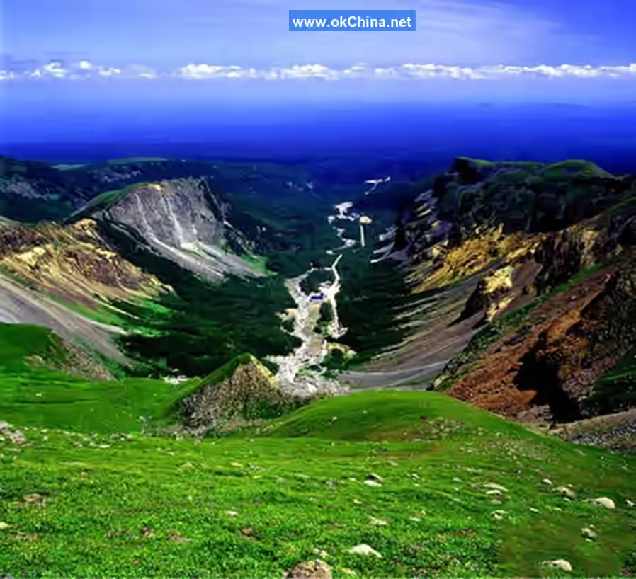
The Underground Forest, also called "Valley Bottom Forest," is the lowest altitude attraction in the northern scenic area of Changbai Mountain. The entrance to the secluded valley forest is about 14 kilometers from the new mountain gate of the northern scenic area. It was formed during the volcanic eruption of Changbai Mountain, accompanied by earthquakes, causing the entire surface to sink vertically, creating a valley-bottom forest with walls up to 70 meters high and a valley bottom 2,500–3,000 meters long.On both sides of the wooden boardwalk grow a variety of plants; pine trees block out the sun, and moss covers the tree trunks. Walking along the boardwalk for 1,000 meters and then turning left for 350 meters leads to the Dongtian Waterfall, while turning right for 500 meters reaches the Valley Forest. The ancient trees in the valley tower into the sky, forming three layers, with massive rocks scattered throughout. The underground forest has a very high concentration of negative oxygen ions and is known as a "natural oxygen bar."
4.2.2 Changbai Mountain U-shaped Valley
Due to the influence of Quaternary glacial tectonic movements, the Changbai Mountain U-shaped Valley was developed by rivers along the structural lines, and the river valleys are mostly embedded in a "V" shape. Under long-term cold disintegration and erosion, the volcanic cone of Changbai Mountain formed a radial gully system, with varying gully sizes due to differences in slope and lithology. The Changbai Mountain U-shaped Valley is a larger gully, with a width of 300 meters and a cutting depth of 100–200 meters. The valley floor is relatively flat, making it a world-famous U-shaped valley.
4.2.3 Butian Stone (Stone to Mend the Sky)
Butian Stone is located by the Tianchi Lake of Changbai Mountain, at the estuary of the Chengcha River. Viewed from a high vantage point, it resembles a giant ivory extending into Tianchi Lake. The Changbai Mountain Jianggang Annals states: "Butian Stone is located east of Longmen Peak, where Tianchi Lake’s water flows out. Half of the stone lies in the water, and half rests on the peak, standing tall and prominent. Observing its shape, it blocks the lake’s outlet, serving as a pillar in the middle of the stream, seemingly mending the defect of Tianchi Lake, hence its name." Liu Jianfeng’s meaning was that this boulder, as large as a hill, mends Tianchi Lake. However, later generations interpreted it as mending the sky. In the Changbai Mountain area, there is a myth of the "Butian Stone Smeltery." People often associate this stone with the goddess Nüwa. Additionally, this massive rock was formed by volcanic lava cooling and solidifying after an eruption, having been tempered by intense heat, with many bubbles and scratches preserved on its surface. Its shape, in particular, resembles a long piece of dough fallen from the sky.
4.2.4 Tamen (Gate)
Tianchi Lake is also called "Tamen." "Ta" originally means a small door. There is a gap between Tianhuo Peak and Longmen Peak, resembling a "small door" created by nature, from which Tianchi Lake’s water flows out.
4.2.5 Heifengkou (Black Wind Gap)
Heifengkou is located on the eastern side of the Changbai Mountain U-shaped Valley, at the junction of the birch forest belt and the alpine tundra. Here, two majestic peaks converge, naturally forming a gap. When wind passes through this gap, its speed naturally increases, so even when the wind is light elsewhere, strong winds blow through Heifengkou. Heifengkou resembles the gate of a castle, open between two fortresses, and is called the "South Heavenly Gate."
4.2.6 Changbai Mountain Gravity Hill
On the tourist road from Tizi River on the western slope of Changbai Mountain to Tianchi Lake, between kilometer markers 17 and 18, there is a slope about 1,500 meters long, known as the Changbai Mountain Gravity Hill. On this slope, cars can ascend without accelerating, and the same phenomenon occurs when tested with a soda can. To unravel the mystery of the "Gravity Hill," Xinhua News Agency reporter Zhou Changqing once invited tourism professionals and geological survey experts to conduct on-site investigations with scientific instruments. The survey results revealed that it was all an optical illusion. What appears to be an uphill slope is actually a downhill slope, with a gradient of about 3 degrees.
4.2.7 Chengcha River
Tianchi Lake’s water flows out along Butian Stone, starting as just a stream. After flowing for one kilometer, the terrain suddenly steepens, and the small river rushes forward. Due to its unique geographical location, this torrent is connected at its "tail" to Tianchi Lake and at its "head" to the waterfall, suspended high on the mountain, hence it is called the "Heavenly River." The Heavenly River is also known as the Chengcha River. "Chengcha" refers to the mythological act of riding a wooden raft to the heavens. Legend has it that during the Han Dynasty, Zhang Qian, while searching for the source of the sea, rode a "cha" (wooden raft) past the moon to a city, where he saw a woman weaving indoors and a man leading an ox to drink from a river. Later, he brought back the "Zhiji Stone" given to him by the Weaver Girl. (See Zhou Mi’s Guixin Miscellaneous Records, citing Jingchu Suishiji.) Bowuzhi, Volume 3 records: "The Heavenly River is connected to the sea. In recent times, someone living on a sea isle... rode a raft and departed." The great Tang Dynasty poet Li Shangyin wrote the poem "Sea Traveler": "The sea traveler rides a raft into the purple aura, the star maiden ceases weaving to hear his tale." The Chengcha River is only 1,250 meters long, making it the shortest river in the world. It connects Tianchi Lake at its tail and meets the Changbai Waterfall at its head.
4.2.8 Small Tianchi Lake
Small Tianchi Lake, also known as Silver Ring Lake, is a parasitic crater lake. It has a circumference of 260 meters, a water area of about 5,380 square meters, a depth of over 10 meters, and a circular shape. Small Tianchi Lake holds two unsolved "mysteries." First, it has only an inlet and no outlet, the opposite of the large Tianchi Lake, yet its water never dries up year-round. Second, it is home to an amphibian called the Siberian salamander, which typically survives only in the Arctic. Locals commonly refer to it as the "baby fish." To the right of Small Tianchi Lake, there is also a "Medicine King Valley," dedicated to the Medicine King Sun Simiao, left behind from the filming of the TV series Fox Volant of the Snowy Mountain. Additionally, the birch forest around Small Tianchi Lake served as the filming location for the "Battle with Red Boy" scene in Journey to the West.
4.2.9 North Slope Tianchi Lake
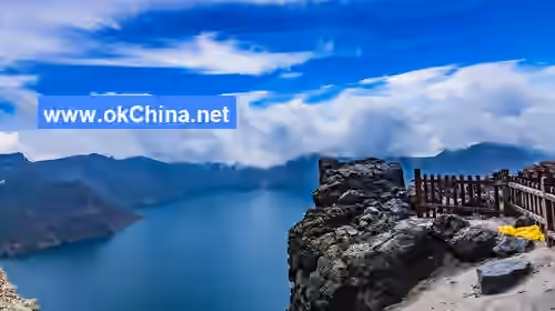
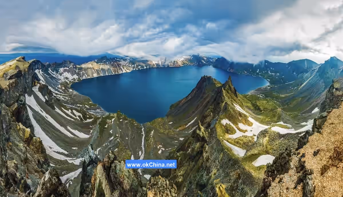
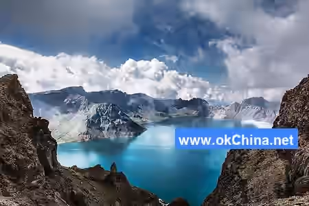
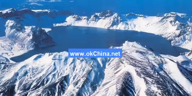
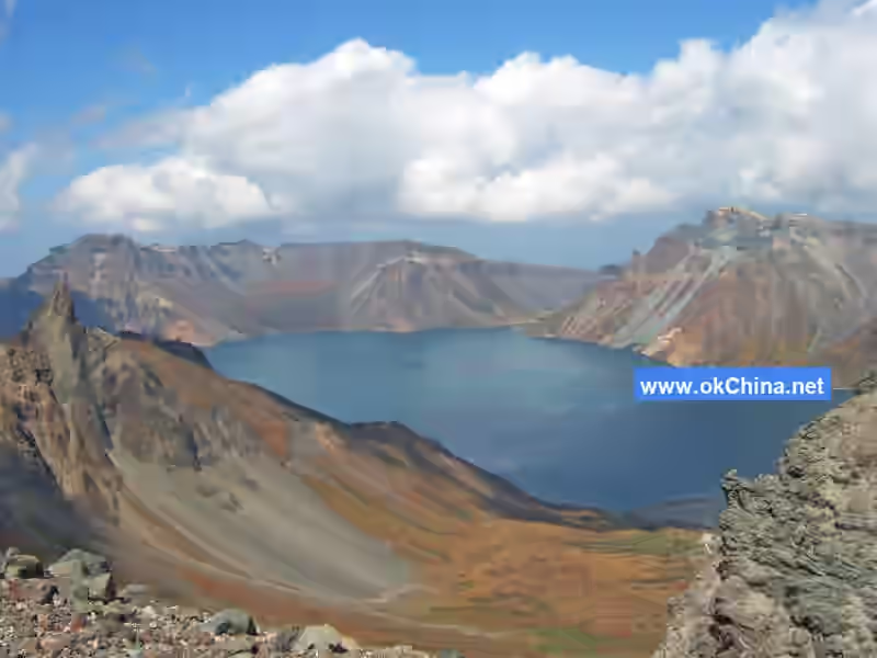
The North Slope Tianchi Lake of Changbai Mountain is located at the top of the main peak’s volcanic cone, slightly elliptical in shape, and is a naturally formed crater lake after volcanic eruptions. It is about 4,400 meters long from north to south and 3,370 meters wide from east to west, with a maximum depth of 373 meters and an average depth of 204 meters. The water surface area is 9.82 square kilometers, with a circumference of 13.1 kilometers. The elevation of Tianchi Lake’s water surface is 2,189.1 meters. Changbai Mountain is the source of the Songhua River, Tumen River, and Yalu River, while Tianchi Lake is the primary source of the Songhua River and also a border lake between China and North Korea. In 2000, Changbai Mountain Tianchi Lake was awarded the Guinness World Record for the "Highest Altitude Volcanic Lake."
4.2.10 Lüyuantan (Green Abyss Pool)
Lüyuantan is located in the birch forest belt and is named for the shade of birch trees and the deep green color of the pool water. On August 14, 2007, Vice Premier Li Lanqing visited Changbai Mountain and personally inscribed its name. The Lüyuantan Waterfall cascades down with a maximum drop of 26 meters. The waterfall splashes onto massive rocks before flowing into the deep pool, which reaches a maximum depth of 10 meters and an average depth of 5 meters.
4.2.11 Changbai Waterfall
The Changbai Waterfall is located north of Tianchi Lake on Changbai Mountain. After Tianchi Lake’s water overflows along Butian Stone, it flows through the 1,250-meter-long Chengcha River and suddenly plunges between Longmen Peak and Tianhuo Peak at a flow rate of 1.25–5 cubic meters per second, forming the Changbai Waterfall with a drop of 68 meters. Due to the high speed and large volume of the falling water, the waterfall has carved a deep, emerald-green pool at the base of the cliff. In 2000, the Changbai Waterfall was listed as the "World’s Largest Drop Volcanic Lake Waterfall" in the Guinness World Records. A poem praises it: "The banks of Baihe River are serene and beautiful, with green waters and cliffs preserved through the ages. It seems as if a dragon pool sprays auspicious snow, like a flying stream hanging from the sky. No need to whip stones to cross the sea, one can ride a raft to question the stars. To truly appreciate the joys of forest and spring, return with companions tomorrow." As the premier scenic spot of Changbai Mountain, the Changbai Flying Waterfall also has the distinctive feature of flowing continuously throughout the year.
4.2.12 Julong Hot Spring Group
The Julong Hot Spring Group covers an area of about 1,000 square meters, with over a hundred water outlets. Among them, 47 have water temperatures exceeding 60°C, with the highest reaching 83°C, classifying it as a high-temperature hot spring. Eggs placed in the hot spring water can be cooked in just 20 minutes. Due to the long geological time required for the formation of hot spring water, it contains a wealth of minerals and trace elements.
4.3 Southern Scenic Area
4.3.1 Yuehua Twin Waterfalls
The Yuehua Twin Waterfalls are located in the southern scenic area of Changbai Mountain. It is a two-tiered small waterfall with a total length of 40 meters—the first tier has a drop of 15 meters, and the second tier has a drop of 25 meters. Surrounded by dense birch forests, the area is serene and secluded. The two tiers of flowing water cascade into waterfalls, with sacred mountains hiding holy water and unique forests accompanying the twin falls, hence its name derived from the birch forest landscape belt. A "Waterfall Viewing Pavilion," a wooden structure in ancient style, is built above the waterfall.
4.3.2 Yalu River Grand Canyon
The Yalu River Grand Canyon is located in the southern scenic area of Changbai Mountain and is the only route to ascend to Tianchi Lake. The canyon is a massive fracture trench formed during volcanic eruptions, shaped over 300 years by rainwater erosion, cutting, and weathering. The canyon is 10 kilometers long from north to south, 200 meters wide from east to west, and 170 meters deep. The Yalu River Grand Canyon is a composite canyon, with two rows of cliffs standing in the Yalu River, shared by China and North Korea.
4.3.3 Carbonized Wood Site
The Carbonized Wood Site is located at an altitude of about 1,400 meters. Carbonized wood is distributed around the volcanic cone centered on Tianchi Lake. The largest breast-height diameter of the carbonized wood can reach 80 centimeters, with an average breast-height diameter of 30–40 centimeters. Their lengths cannot be measured because the carbonized wood pieces are broken. Experts explain that the carbonized wood discovered on the southern slope of Changbai Mountain resulted from incomplete combustion of local trees during a volcanic eruption over 1,000 years ago. Many trees are not fully carbonized. According to existing identification results, the carbonized wood includes coniferous species such as Korean pine, spruce, sand pine, and Changbai larch, as well as broadleaf species such as purple catalpa, birch, Manchurian ash, and bird cherry.
4.3.4 Changbai Stone Forest
The Changbai Stone Forest is located in the Gangxia Valley at the Hengshan No. 8 Gate mountain end in Changbai County, by the Yalu River. It includes peaks such as Tiger Tooth Peak, Camel Peak, and Gutou Island, forming a group of stone pillars on the southern foothills of Changbai Mountain.
4.3.5 Hutiao Gorge Waterfall
The Hutiao Gorge Waterfall consists of four cascading tiers, making it the waterfall with the most tiers among the waterfall groups of Changbai Mountain. It is described in detail in Changbai Scenery. This is the uppermost gorge of the Shiwudao River, where the riverbed is narrow and strewn with reefs. Tigers could step on the reefs to cross the river, hence the name "Hutiao Gorge" (Tiger Leaping Gorge). Here, the sloping cliffs feature several massive reefs scattered in the river.The lumberjacks praised this waterfall, naming its first level "White Dragon Trailing Silk," the second "White Dragon Piercing the Ravine," the third "White Dragon Spitting Pearls," and the fourth "White Dragon Entering the Pool." Hence, they called this wonder "White Dragon Roaming the Ravine."
5. Cultural Connotation
5.1 Origin of the Names
Throughout its long history, Changbai Mountain has been known by various names such as Buxian Mountain, Gaima Mountain, Xitai Mountain, and Taibai Mountain.
Buxian Mountain: Classic of Mountains and Seas: The Great Wilderness: North states: "Beyond the northeastern sea,... in the great wilderness, there is a mountain named Buxian, where the Sushen people reside." By the Warring States period and the early Western Han Dynasty, Buxian Mountain was already renowned in the Central Plains. Book of Jin: Records of Foreign Peoples notes: "The Sushen people, also known as Yilou, live north of Buxian Mountain." Comprehensive Institutions records: "Yilou is the ancient Sushen, and their state is north of Buxian Mountain." Taiping Huanyu Ji mentions: "The state of Yilou is north of Buxian Mountain, a thousand li north of Fuyu." Annotations to the Book of Jin explains: "Buxian Mountain is Changbai Mountain. 'Buxian' is a transliteration of the Manchu phrase 'Boluonie Xianqian,' meaning 'long white.' The term 'Buxian' originates from the ancestors of the Manchu people, fitting the historical context of the Manchu and their predecessors inhabiting this area and the unique characteristics of Changbai Mountain."
Xitai Mountain: During the Northern and Southern Dynasties, Changbai Mountain was also called "Xitai Mountain." Book of Wei: Biography of Wuji records: "To the south of the state lies Xitai Mountain, known as 'Taihuang' in Wei language." History of the Northern Dynasties: Biography of Wuji states: "To the south of the state is Xitai Mountain, known as 'Taihuang' in Chinese, and it is deeply revered by the people." Both New Book of Tang: Records of the Northern Di and Book of Sui: Biography of Jietuo refer to it as "Xitai." The character "徙" in Xitai Mountain is sometimes written as "徙" or "从." Wang Hualong's General Treatise on Northeast Geography considers "徙" correct, suggesting that "链" is a miswriting of "徙." The mountain was called "Taibai" in Wei language and "Taihuang" in Chinese, with "皇" carrying the meaning of "white." "徙" is pronounced "si" in Jiyun, similar to the pronunciation of "咸" in "Buxian Mountain" and "訾" in "Mazi River," all meaning "white" in Manchu. "从" likely represents the traditional character "徒," a variant of "徙," while "徒" should be regarded as a miswriting.
Taibai Mountain: By the Tang Dynasty, Changbai Mountain was also known as Taibai Mountain. New Book of Tang: Biography of Bohai records: "The remnants of Jietuo and Goguryeo fled eastward, 'crossed the Liao River, and fortified themselves northeast of Taibai Mountain, relying on the Aolu River to build defenses.'" Biography of Heishui Jietuo states: "The Sumo tribe resides farthest south, reaching Taibai Mountain, also called Xitai Mountain, bordering Goguryeo and living along the Sumo River, which originates from the mountain and flows northwest into the Talou River." During the Tang Dynasty, the Liao River referred to the present-day Liao River, and the Sumo River corresponds to the upper reaches of the Songhua River. Comprehensive Geography of the Great Qing notes under the Jilin Mountains and Rivers entry for the Huntong River: "Now called the Songhua River, it originates from Changbai Mountain, flows north to converge with the Nen River and the Heilongjiang River, and empties into the sea. [23] This is the ancient Sumo River." The entry for Changbai under Jilin Mountains and Rivers states: "Ancient names include Buxian Mountain, also known as Taibai Mountain or Bai Mountain." Thus, Taibai Mountain undoubtedly refers to present-day Changbai Mountain.
Changbai Mountain: From the Liao and Jin dynasties onward, the name Changbai Mountain became widely used. History of Liao: Records of Officials notes in the 30th year of Emperor Shengzong's reign (1012): "Thirty tribes of the Jurchen in Changbai Mountain." History of Jin records: "The Heishui Jietuo inhabit the ancient land of Sushen, where there is a mountain called Bai Mountain, which is Changbai Mountain..." History of Jin, Volume 35: In the twelfth month of the 12th year of the Dading era (1172), Changbai Mountain was enfeoffed as "King of Prosperous Nation and Divine Response." In the third month of the 15th year of Dading (1175), rituals and offerings for the enfeoffment were established, with sacrifices conducted biannually in spring and autumn. In the tenth month of the 4th year of the Mingchang era (1193), it was further enfeoffed as "Emperor of Opening Heaven and Vast Holiness." The Qing Dynasty continued to use the name Changbai Mountain. Draft History of Qing records: "Changbai Mountain is located here, with Tianchi on its summit, formerly known as Tamen." The name Changbai Mountain reflects the mountain's characteristics, which have been extensively documented throughout history. General Gazetteer of Shengjing notes: "The mountain peak bears no other trees, and the grass is adorned with white flowers." Changbai Huizheng Lu states: "The mountain is perpetually snow-covered, with no vegetation, appearing entirely white—hence the name Changbai Mountain." The name Changbai Mountain has also influenced administrative divisions. The Liao Dynasty established the "Changbai Mountain Jurchen Grand Prefecture," the Qing Dynasty established "Changbai Prefecture," the Republic of China renamed it "Changbai County," and the People's Republic of China established the "Changbai Korean Autonomous County," among others. By 2000, the name Changbai Mountain had a history of nearly a millennium, becoming the definitive name for the mountain.
5.2 Special Activities
In 2019, the China Changbai Mountain International Forest Snow Marathon Festival grandly commenced in the North Scenic Area of Changbai Mountain, pioneering a new model for outdoor snow marathons.
In March 2022, the General Office of the Central Committee of the Communist Party of China and the General Office of the State Council issued the Opinions on Building a Higher-Level Public Service System for National Fitness, proposing research and promotion of the construction of an Ice and Snow Silk Road Belt in areas such as Changbai Mountain in Jilin (non-red line zones).
5.3 Myths and Legends
Sixteen Peaks
The origin of the "Sixteen Peaks of Changbai" is associated with a poignant folk tale.
Legend has it that long ago, the third son of the Dragon King of the East Sea was spoiled and idle. One day, the Jade Emperor held a grand banquet for his ministers, and the Dragon King of the East Sea brought his third son along. During the feast, the third son sneaked out and stole a precious pearl from the Queen Mother of the West. The Queen Mother reported the theft to the Jade Emperor, who was enraged and immediately dispatched sixteen heavenly generals to pursue the third son, ordering them to retrieve the pearl at all costs. Over Changbai Mountain, the sixteen generals finally caught up with the third son and surrounded him. A fierce battle ensued over the pearl. Outnumbered, the third son heard a "crack" as one of his dragon horns was severed by a heavenly general. In excruciating pain, he lost his grip, and the pearl fell onto the summit of Changbai Mountain. With a thunderous roar, the pearl transformed into a bottomless emerald pool—Tianchi. Seeing this, the third son immediately turned into a one-horned dragon and hid in the waters of Tianchi. To this day, it is said that the frequent storms, clouds, and mist over Tianchi are caused by this one-horned dragon.
The sixteen heavenly generals, seeing the third son transform into a one-horned dragon and dive into Tianchi, surrounded the pool, waiting for him to surface so they could capture him. However, the third son, aware of the generals' vigilant watch, dared not emerge easily. Over time, the sixteen loyal generals transformed into sixteen majestic and imposing peaks, standing guard eternally beside the pearl-like Tianchi.
Ginseng Stories
For thousands of years, the king of herbs, ginseng, has inspired countless legends. Tales of wild ginseng protected by grass and small trees, giant snakes guarding ginseng, and stories of ginseng babies are too numerous to count. In Fusong County, Baishan City, one such story about weasels paying homage to the Ginseng King is widely circulated.
Once, an old ginseng digger unearthed an exceptionally large ginseng weighing nine liang and two qian (using the old measurement system where sixteen liang equaled one jin) in a nearby forest. As the saying goes, seven liang is ginseng, eight liang is treasure, and a ginseng weighing over nine liang is a treasure among treasures. He brought it home and stored it in his warehouse, having his two sons guard it day and night. One night, he suddenly heard noises from the warehouse. Lighting a lantern, he went to investigate and found his two sons asleep from exhaustion. Dozens of weasels were gathered around the large ginseng, paying homage to it. Seeing the man enter, the weasels calmly and orderly departed. The old man, relieved to find the ginseng unharmed, breathed a sigh of relief.
Comments
Post a Comment