Arshihatu Stone Forest
I. Introduction
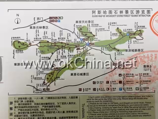
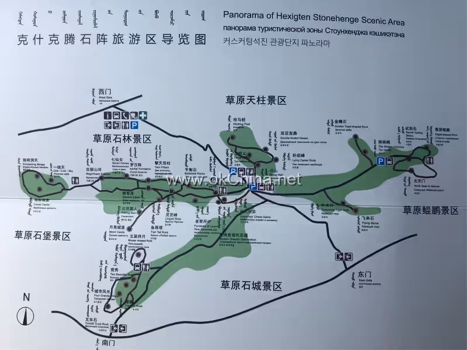
The Arshihatu Stone Forest Scenic Area, also known as Arshihatu Stone Forest, is located in Bayan Ulagacha, Bayan Chagan Sumu, Hexigten Banner, Chifeng City, Inner Mongolia Autonomous Region. Situated in the northern part of the Hexigten Global Geopark, it is the most representative scenic area among the nine major parks within the Hexigten Global Geopark. "Arshihatu" is a Mongolian term meaning "precipitous rocks." The Arshihatu Stone Forest is distributed on the North Da Mountain, about 40 kilometers north of Huanggang Peak, the highest peak of the Greater Khingan Range, at an altitude of approximately 1,700 meters. The stone forest stretches along the mountain ridge in a northeast direction, covering an area of about 15 square kilometers. The Arshihatu Stone Forest is a masterpiece left by Quaternary glaciers and is a unique granite geological wonder in the world. The Arshihatu Stone Forest Scenic Area consists of five major scenic zones: the Grassland Stone Forest, Grassland Heavenly Pillar, Grassland Kunpeng, Grassland Stone City, and Grassland Stone Fortress. The main attractions include stone landscapes such as Moon Castle, Riding the Wind and Waves, Seven Fairies, Balancing Rock, Oath of the Peach Garden, Hitching Post, Kunpeng Landing on the Grassland, and Flying Rock.
II. Orientation and Layout
Geographical Location
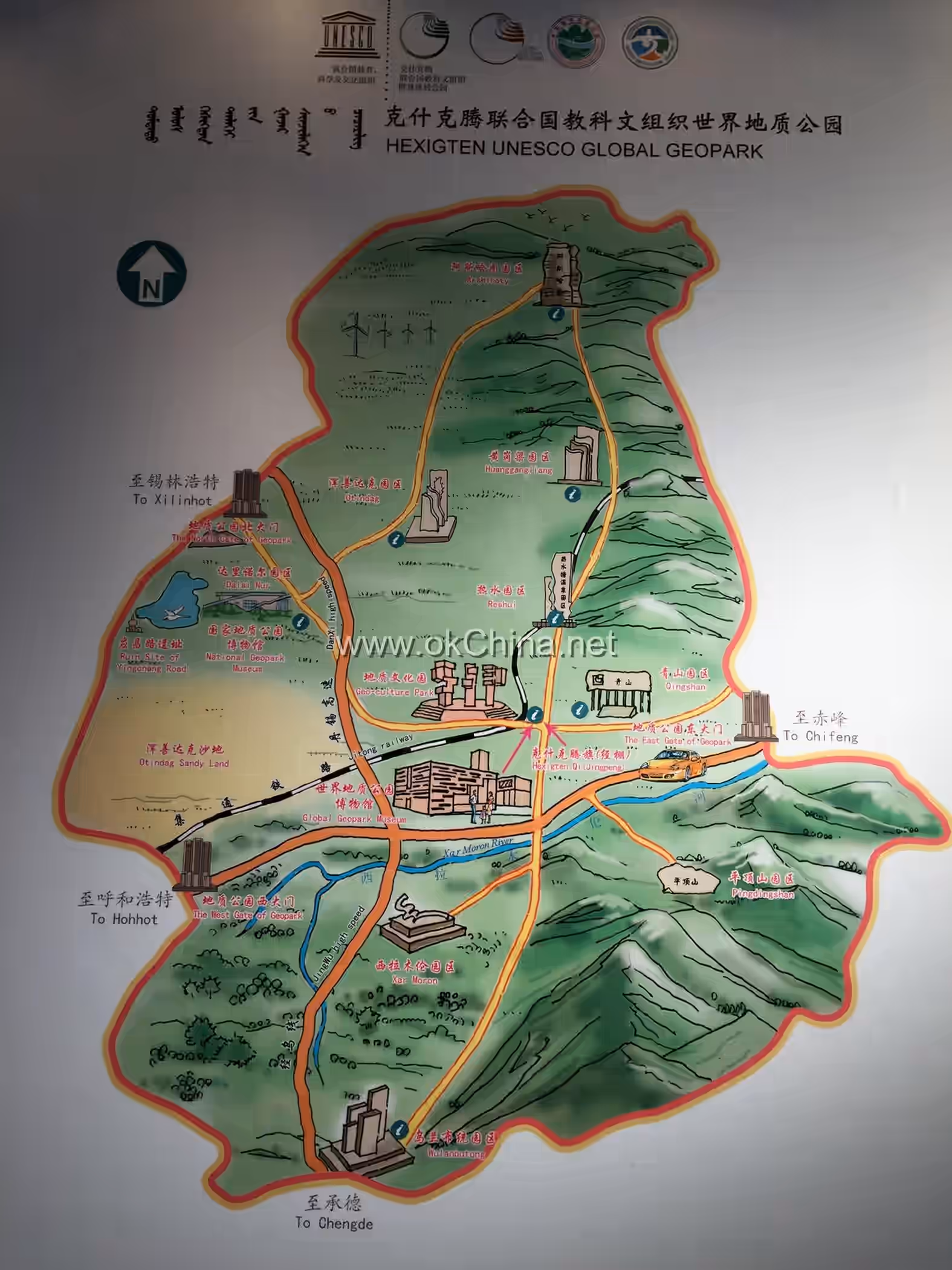
The Hexigten Global Geopark in Inner Mongolia is located in the eastern part of the Inner Mongolia Autonomous Region and the northwestern part of Chifeng City. It lies at the convergence of the Inner Mongolia Plateau, the southern end of the Greater Khingan Range, and the Qilaotu Mountains of the Yanshan Range. Its geographical coordinates are approximately 116°30′00″ to 118°20′00″ east longitude and 42°20′00″ to 44°10′00″ north latitude. Since the Quaternary period (about 1.75 million years ago), multiple phases of ancient glaciation have occurred here. Nearly a thousand ancient glacial potholes, well-preserved and typical in form, have been left on Qing Mountain, constituting a rare large-scale ancient glacial pothole group in the world. Additionally, there are other ancient glacial relics such as cirques, glacial U-shaped valleys, glacial striations, lateral moraines, and terminal moraine ridges. Details
Climate
The Hexigten Global Geopark in Inner Mongolia features a mid-temperate continental monsoon climate. Summers are short, cool, and temperate, while winters are long and cold. The temperature difference between day and night is significant, and the arrival of autumn is pronounced. Based on climatic characteristics, topography, terrain, and vegetation, the area is divided into four climatic zones: the cool-cold semi-humid pastoral temperature zone, the cold semi-arid pastoral climate zone, the cold semi-humid forestry climate zone, and the cool semi-arid agricultural climate zone.
Hydrology
The river systems within the Hexigten Global Geopark in Inner Mongolia are divided into two types based on topography and flow direction: exorheic (outflowing) systems and endorheic (inland) systems. The exorheic systems belong to the Xar Moron River system and the Luan River system. The endorheic systems include inland rivers and inland lakes, with approximately 60 natural lakes covering a water area of about 420,000 mu (approximately 280 square kilometers), mostly distributed in the western high-plain region and the southwestern Hunshandak Sandy Land area.
Geology
The Hexigten Global Geopark is situated at the junction of three major landforms: the Greater Khingan Range, the Yanshan Mountains, and the Hunshandak Sandy Land.
The Hexigten Global Geopark is a comprehensive global geopark composed of relics or landscapes including Quaternary glacial遗迹, granite landforms, platform-trough structural suture zones, plateau lakes, rivers, volcanic landforms, deserts, grasslands, hot springs, and plateau wetlands. On the North Da Mountain, a branch of the Greater Khingan Range, there are peculiar granite landform landscapes. The granite stone forest landform groups exhibit various shapes, with well-developed horizontal and vertical joints. The development of horizontal joints, on one hand, releases internal stress within the rock mass, preventing rock collapse under gravity due to oblique joints. On the other hand, horizontal joints significantly slow down frost wedging. Vertical joints of varying density divide the rock mass into blocks with different weathering resistance, which eventually evolve into the granite stone forest. The Dalinor Volcanic Group landform is one of the nine major volcanic areas in Northeast China. Its volcanic cones come in various forms and are referred to as the "miniature landscape of the Wudalianchi Volcanoes." Within the geopark, there are also hot springs, deserts, grasslands, lakes, rivers, high mountain valleys, granite intrusions in the Greater Khingan and Yanshan Ranges, and mineral resources. Additionally, traces of prehistoric human activity can be found within the geopark, with several prehistoric human relics preserved.
Formation Causes
The Arshihatu granite stone forest landform has two main characteristics. First is the layered nature of the granite. The exposed granite exhibits very good pseudo-bedding, closely resembling sedimentary rock layers. Second is the distribution pattern; this type of granite stone forest is mainly distributed along the ridges of North Da Mountain. The development process of the granite stone forest is closely related to the geomorphological evolution of the area, roughly going through three stages. Intrusion-Exposure Stage: The Arshihatu granite intruded during the Late Jurassic, approximately 150 million years ago. After multiple uplift and planation events of the Greater Khingan Range, the granite was exposed on the second-level planation surface. Glaciation - Stone Forest Embryonic Stage: During the Quaternary period, valley glaciers were extensively developed in the North Da Mountain area. Glacial abrasion and plucking strongly modified the original landforms, creating glacial features such as cirques, glacial erosion depressions, arêtes, and horns. During glacial flow, the immense weight of the ice generated shear forces parallel to the ground surface on the granite, leading to the development of nearly horizontal joints within the granite. All locations where stone forests are currently developed are invariably situated on ridge peaks, precisely where glaciers formed arêtes or horns. This constituted the embryonic form of the granite stone forest. Weathering - Stone Forest Shaping Stage: The embryonic granite stone forest forms on ridge peaks. Under the influence of physical weathering, chemical weathering, and freeze-thaw weathering, various fissures gradually expand along the well-developed joints. Under gravity, the rock mass gradually decomposes and collapses, forming distinct individual stone walls, pillars, etc. Intense wind erosion rounds off the sharp edges of the stone forest, giving the overall forms a rounded appearance. As the windward side experiences far stronger wind erosion than the leeward side, most stone features exhibit a concave-convex characteristic. Continued weathering can cause further collapse or toppling of the granite stone forest. The stone forest gradually becomes shorter and eventually disappears.
III. Major Scenic Areas
Stone Forest Landscapes
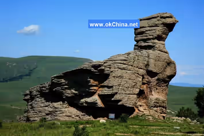
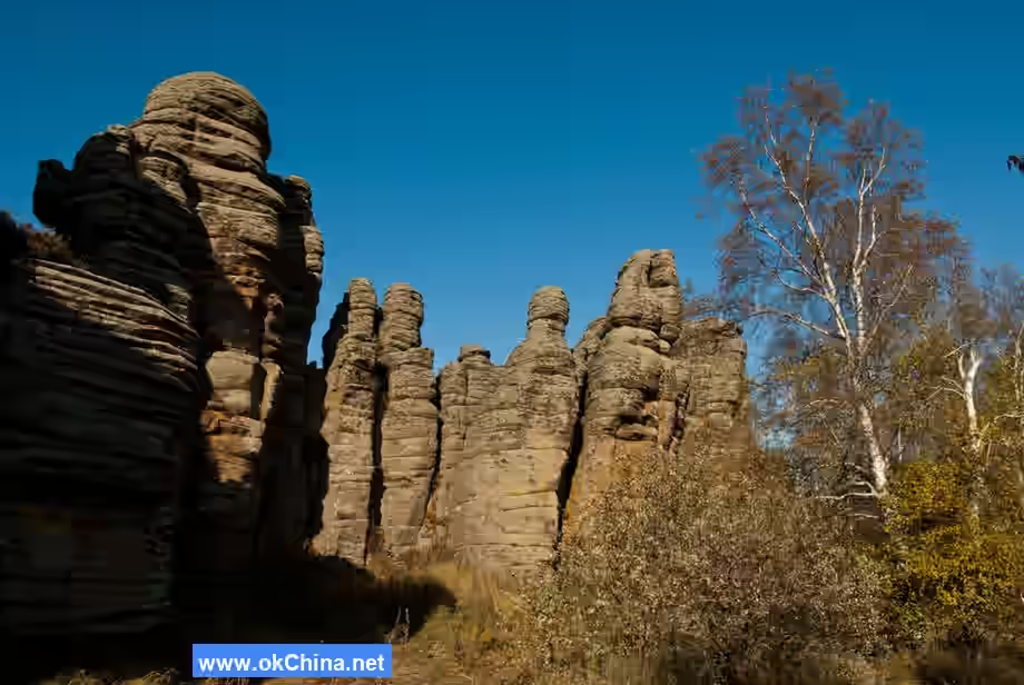
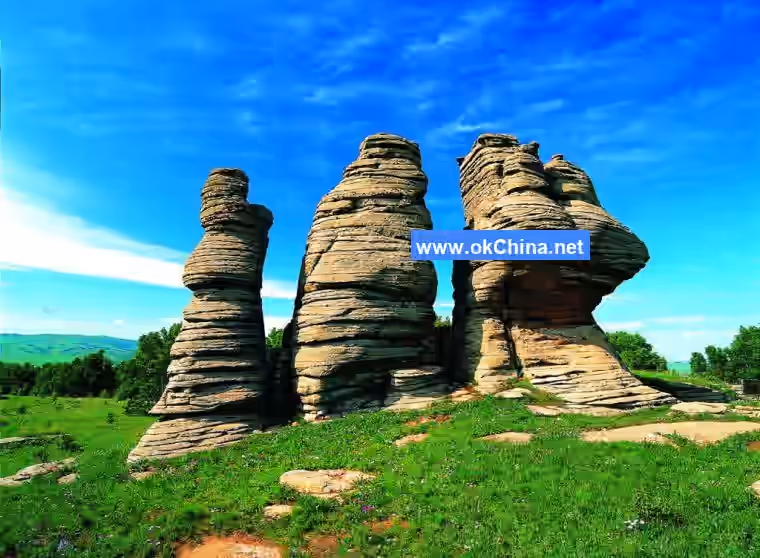
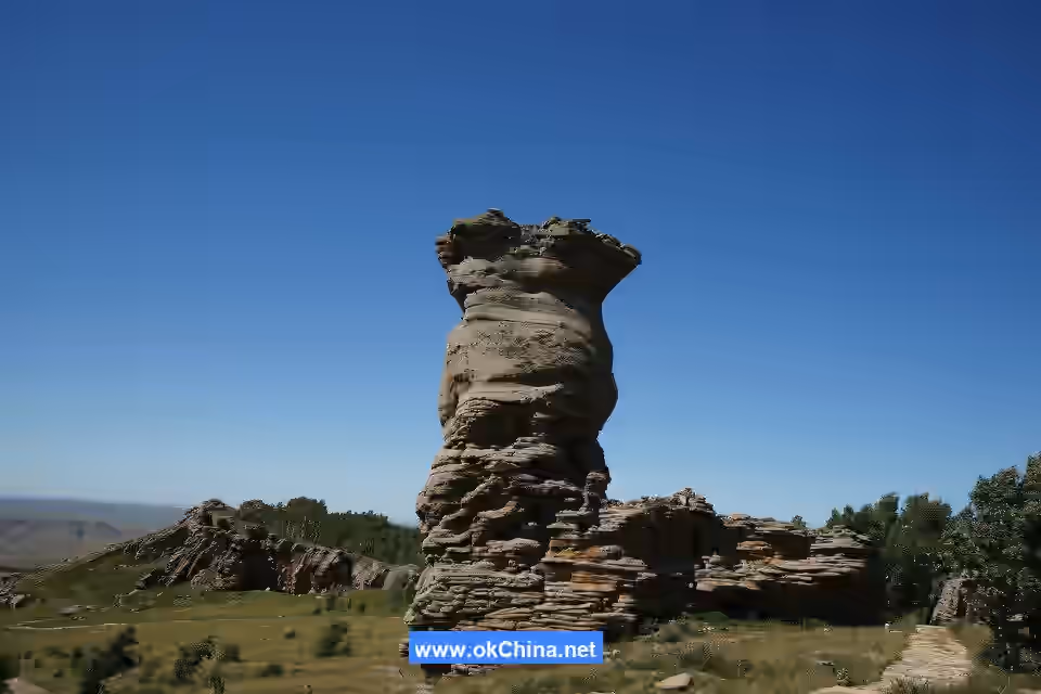
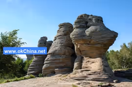
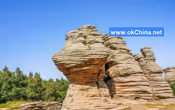
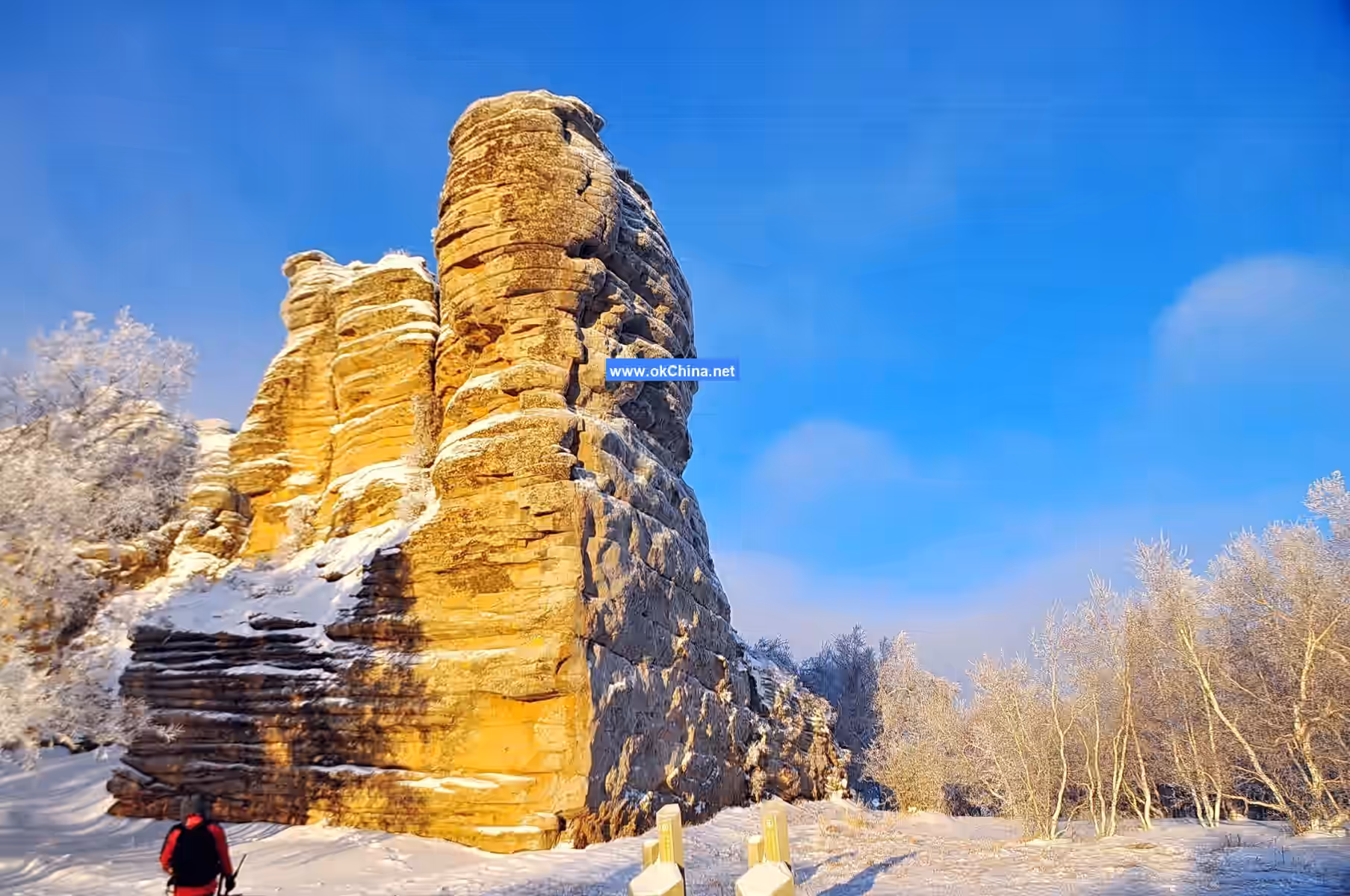
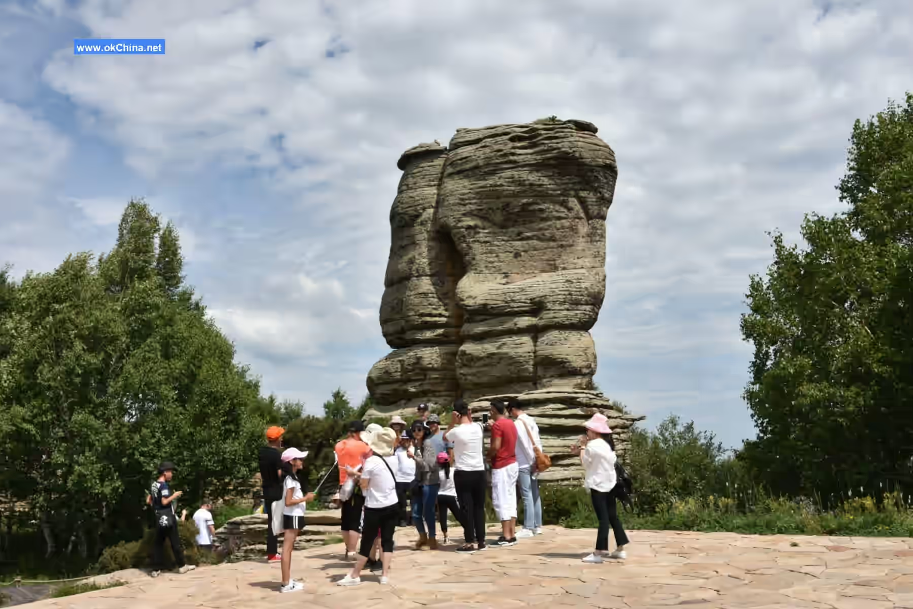
The Arshihatu Stone Forest is mainly distributed on North Da Mountain within the Greater Khingan Range. Some stone forests appear in clusters, stretching for hundreds of meters and tens of meters wide, with relative heights of 5-20 meters. Viewed from afar, they resemble a forest; up close, they appear as peaks, varying in height and presenting ever-changing forms. Some stand independently as pillars, reaching 5-20 meters in height, with diameters generally between 2-5 meters, taking on circular, square, or rectangular shapes. They stand tall and majestic, appearing perilously poised to topple against the backdrop of blue sky and flowing clouds. Some resemble humans, objects, or city walls, inspiring boundless imagination. Some stone forests feature well-developed horizontal joints, layered like a thousand-layer cake, while others are thick at the top and thin at the bottom, shaped like mushrooms. The Arshihatu granite stone forest, with its peculiar shapes and myriad forms, is a landscape of变幻 (transforming) rocks. Its diverse and varied configurations possess high观赏 (aesthetic) value.
Comments
Post a Comment