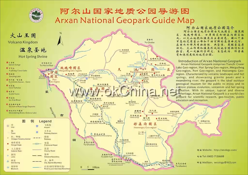
Arxan-Chahe Scenic Area
I. Introduction
The Arxan-Chahe Tourist Scenic Area in Xing'an League is located in the northeastern part of the Inner Mongolia Autonomous Region. It is a comprehensive tourist destination encompassing natural landscapes, eco-tourism, and cultural experiences, covering an area of 13,168.7 square kilometers. It spans Arxan City and the Chahe Town of Zhalantun City in Hulunbuir, bordering Heilongjiang Province, Jilin Province, and Mongolia.
This scenic area is renowned for its abundant natural resources. Its main attractions include Tianchi (Heavenly Lake), Santan Gorge, Dichi (Earth Pool), Shitanglin (Stone Pond Forest), Azalea Lake, Camel's Hump Ridge Heavenly Lake, and the Grand Canyon. Additionally, there are subsidiary scenic spots such as the Unfrozen River, Turtleback Rock, and Rose Peak, as well as important nature reserves like the Arxan National Forest Park and the Haosengou National Forest Park.
In 2017, the Arxan-Chahe Tourist Scenic Area was honored as a National AAAAA Tourist Attraction, highlighting its significance in the tourism industry. The area boasts not only rich natural landscapes but also profound cultural heritage. It is home to Mongolian communities, and visitors can explore the Arxan Natural Museum and the Arxan National Geological Museum to gain a deeper understanding of the region's natural history and geological evolution.
Furthermore, the scenic area has received numerous accolades, such as "China's Most Beautiful Forest Tourism Scenic Area," and has obtained certifications for ISO9001 Quality Management System and ISO14001 Environmental Management System. It is easily accessible by both self-driving tours and public transportation, making it suitable for tourists of all ages for sightseeing, leisure, vacationing, and various other activities.
II. Orientation and Layout
Geographical Location
Arxan is a border city in eastern Inner Mongolia, spanning the southwestern foothills of the Greater Khingan Range. Its geographical coordinates are between 119°28′ and 121°23′ east longitude and 46°39′ and 47°39′ north latitude. Chahe Town is located 185 kilometers southwest of Zhalantun city center, with coordinates between 120°36′ and 121°46′ east longitude and 47°05′ and 47°45′ north latitude. The Arxan-Chahe Tourist Scenic Area lies within the central ridge of the Greater Khingan Range, with an average elevation of 1,100 meters. It experiences a cold-temperate continental climate, with an annual average temperature of -3.1°C. The coldest month averages -25.6°C, while the highest average temperature is 16.6°C. The average annual precipitation is 460 millimeters. The vegetation coverage rate is 95%, with forest coverage at 64%, belonging to the circum-boreal cold-temperate coniferous forest zone. The full name "Hālún · Ā'ěrshān" is Mongolian, translating to "hot holy water" in Chinese, reflecting the city's reputation as a tourist resort famous for its water and hot springs. The combined population of Arxan City and Chahe Town in Zhalantun is 64,000, comprising a multi-ethnic community of 13 ethnic groups including Mongolian, Han, Hui, Manchu, Korean, Daur, Ewenki, Oroqen, Monba, and Xibe.
The Arxan-Chahe Scenic Area is strategically located at the core of the economically developed region of eastern Inner Mongolia. It enjoys convenient transportation links with surrounding cities, positioning it to integrate tourism resources from Manzhouli, Hailar, Zhalantun, Ulanhot, Xilinhot, and other areas, thereby playing a key role in constructing Inner Mongolia's golden tourism region. Simultaneously, Arxan City is situated within the hinterland of the Northeast Asian economic circle and serves as the western gateway of China's Northeast Economic Zone. It borders Mongolia to the west with a border line of 93.531 kilometers. According to feasibility studies and planning by the United Nations Development Programme (UNDP), constructing a railway from Arxan to Choibalsan in Mongolia could establish a new Eurasian Land Bridge connecting Tumen in the east with Mongolia and Russia in the west, facilitating connectivity across Northeast Asia. Arxan would then become the "bridgehead" of this Eurasian Land Bridge, underscoring its crucial economic and geographical importance.
Climatic Conditions
Arxan City is situated in a unique geographical environment where altitude gradually increases from southwest to northeast. It is primarily influenced year-round by the warm, moist air currents from the southeast ocean and the dry, cold air currents from the northwest. The climate is classified as a cold-temperate continental monsoon climate, with characteristics of a continental alpine climate zone, resulting in distinct local microclimates. Annual temperatures are generally low, the frost-free period is short, and there are significant annual and daily temperature variations.
Seasonal Characteristics
Arxan City exhibits unique seasonal features: spring and autumn are essentially connected, summer characteristics are not pronounced, and winter is long and cold. Seasonal variations in sunlight, heat, water, and wind are distinct.
Spring to Autumn In Arxan City, spring typically begins on May 6th and autumn ends on September 20th, with the combined spring-autumn period lasting approximately 138 days. Temperatures rise rapidly in spring, with large daily temperature ranges. Cold and warm air masses alternate frequently, occasionally bringing snowfall and "late spring cold" phenomena. Precipitation variability is high, and the likelihood of spring drought is relatively low. The number of windy days increases. The highest annual temperatures occur in July, coinciding with increased precipitation and abundant moisture. Severe convective weather such as rainstorms and hail occurs relatively frequently, potentially harming crops. However, the concurrent presence of heat and moisture is also the peak growing season for crops. From late August to mid-September, temperatures drop significantly, precipitation decreases markedly, the temperature difference between day and night increases, and autumn frost appears. The annual frost-free period is about 90 days.
Winter Winter in Arxan City is long and cold, typically starting on September 21st and ending on May 5th, lasting over seven months (227 days). Influenced by northwestern cold air and controlled by the Mongolian High, cold air masses linger for extended periods, leading to frequent cold waves and snowy weather. The severe cold period lasts over three months, with snow cover lasting 152.2 days on average. Average winter snowfall is about 30 mm, accounting for 6.5% of the annual precipitation. The extreme minimum temperature was -45.7°C, recorded on January 19, 1966. Strong winds occur occasionally.
III. Main Attractions
Tianchi (Heavenly Lake)
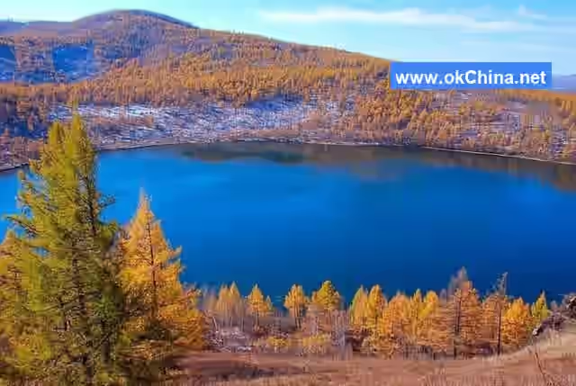
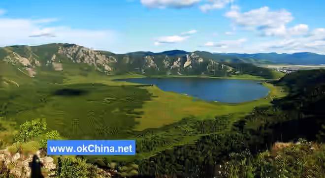
Tianchi is located on Tianchi Ridge, 74 kilometers northeast of Arxan City, at an altitude of 1,332.3 meters. It is the third highest heavenly lake in China, lower than the Baekdu Mountain Tianchi in Jilin Province and the Bogda Peak Tianchi in the Tianshan Mountains of Xinjiang. Tianchi is a crater lake formed by water accumulation in a volcanic crater after an eruption. It is a special type of closed crater lake known as a maar lake, as it has no rivers feeding into it or channels draining from it. Maars are formed by explosions resulting from the interaction between magma and water vapor. The walls surrounding a maar lake are generally several to tens of meters high, with relatively flat tops. The lake water is clear and calm, tens of meters deep, although some maars are dry without water. There are seven large, well-preserved maar lakes within Arxan's territory, and Tianchi is one of them. Tianchi is elliptical, 450 meters long from east to west, 300 meters wide from north to south, covering an area of 13.5 hectares. The lake water neither dries up during prolonged droughts nor overflows during heavy rains, remaining as smooth as a mirror. The scenery of Tianchi is beautiful. A stretch of emerald water reflects the green mountains and trees. Ancient pines surround the lakeshore, clusters of vibrant mountain flowers add color, creating a magnificent and varied scene.
Shitanglin (Stone Pond Forest)
Shitanglin is located east of Tianchi, 84 kilometers from Arxan City, and is one of the wonders of the Greater Khingan Range. Entering Shitanglin is like stepping into a natural, complete volcanic rock museum. It features geological relics formed by multiple volcanic eruptions during the Quaternary period. The erupted lava covered the ground, forming extensive lava sheets and lava blankets. Lava elevated above the ground often forms platforms. Within the large-scale volcanic lava landforms, a turtleback-like lava structure has been discovered. According to scientific research experts, this is currently the largest, best-developed, and most completely preserved lava structure in China. The lava domes found here are also a type of basalt landform currently unique to this location in the country.
Azalea Lake
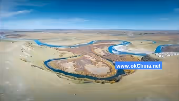
Azalea Lake is located 92 kilometers northeast of Arxan City, covering an area of 128 hectares. It is named for the azalea flowers blooming all around its shores. The lake is L-shaped, with an inlet in the southeast and an outlet in the southwest. It connects to Songye Lake upstream and links to the Halaha River downstream. The average depth is 2.5 meters, with the deepest parts exceeding 5 meters. It is a flowing, living water lake. Azalea Lake was formed by volcanic lava blocking a river channel and impounding water, creating a barrier lake. In contrast, Tianchi, located only 14 kilometers away, is a crater lake formed by water accumulation in a volcanic crater. The former is called a barrier lake, the latter a crater lake. Within Arxan, one can see both types of lakes formed by volcanic activity. Volcanology expert Liu Jiaqi said, "A place like Arxan, which has both crater lakes, maar lakes, and barrier lakes, can be called a complete collection of volcanic lakes, which is very rare." The environment around Azalea Lake is tranquil and picturesque. When spring returns, dense clusters of azaleas burst into brilliant bloom along the shore, their reflection turning the lake surface into a brocade-like spectacle, resembling rosy clouds or flames, overwhelmingly beautiful. Wild ducks gather on the lake, while gray cranes and swans inhabit the area; schools of Amur minnows compete for food. Flowers and trees alternate along the lakeshore, creating a clear contrast of red and green. In summer, aquatic plants on the lake sway in the wind, releasing a refreshing fragrance. In autumn, the water is as clear as a mirror, with fish darting about. In winter, Azalea Lake becomes a natural skating rink.
Songye Lake (Pine Needle Lake)
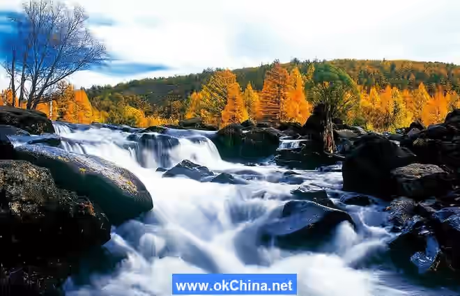
Songye Lake, originally named Da'erbin Lake, is located 10 kilometers southeast of Azalea Lake, 12 kilometers from Xing'an Forestry Center, and 102 kilometers from Arxan City. Covering an area of 314 hectares, it is the largest among the barrier lakes in Arxan. The water of Songye Lake flows northward into Azalea Lake via the Bahao Creek. The lake is 1,300 meters long from north to south and 150 meters wide from east to west. Viewed from north to south, the lake surface is crescent-shaped, where sky meets water and water meets sky, blending into one. Mountains flank the east and west sides. To the southwest of the lake stands Arxan's second-highest peak, Telmei Peak, at 1,711.7 meters above sea level. A fire lookout tower is built on the mountain. At the southern end of the lake, there is a small waterfall about 5 meters high. Songye Lake has a flat bottom, a broad surface, and fertile water quality, abundant in wild fish. The lakeshore features steep, rugged mountains and peaks covered with dense virgin forest. Every golden autumn, the dense larch needles from the shores fall into the lake, shimmering brilliantly. This area retains its original, wild charm and is an excellent destination for seeking tranquility, exploration, and boating.
Luming Lake (Deer Cry Lake)Deer Call Lake is a lake formed by lava flows from volcanic eruptions that blocked the Halaha River during their movement. Originally named "Third Paozi," it is located 3 kilometers from Xing'an Forest Farm. With an elevation of approximately 1,190 meters, the lake features a broad surface area of 157 hectares. The Halaha River flows in from the southeast and exits at the southwestern end of the lake. The lakeshore is lush with water plants and grasses, and Deer Call Lake is surrounded by mountains on three sides, creating a very tranquil environment. Deer are often seen roaming and playing here, hence the name Deer Call Lake.
Wusulangzi Lake
Wusulangzi Lake is a lake formed by lava flows from volcanic eruptions that blocked the Halaha River during their movement. Originally named "49th Paozi," it covers a water area of 135 hectares with an average depth of 2.5 meters. Surrounded by mountains on all sides, the lake surface is mirror-like, and the water is rich in nutrients, abundant in cold-water fish such as carp and whitefish. Based on its geomorphological features and water distribution characteristics, Wusulangzi Lake may also be a crater lake formed by volcanic eruptions.
Scots Pine Forest
The Scots Pine Forest is located at the southern end of the Scots pine forest belt on the western slope of the Greater Khingan Mountains. This forest is vegetation that has developed under specific ecological conditions, characterized by rapid growth, strong adaptability, and excellent windbreak and sand-fixation effects. The forest here is dense, with upright trunks, twisted branches, and intertwined roots. In midsummer, the canopy blocks the sun, creating a deep and serene landscape.
Santan Gorge
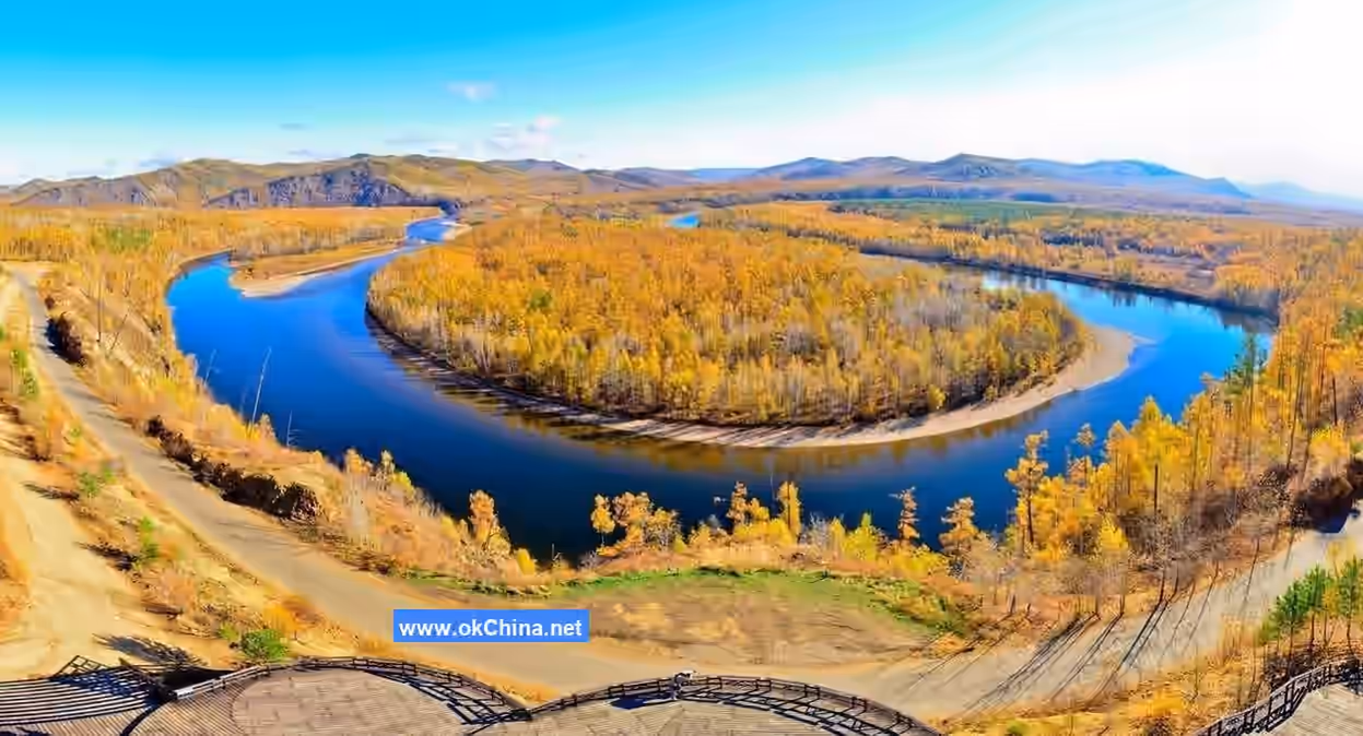
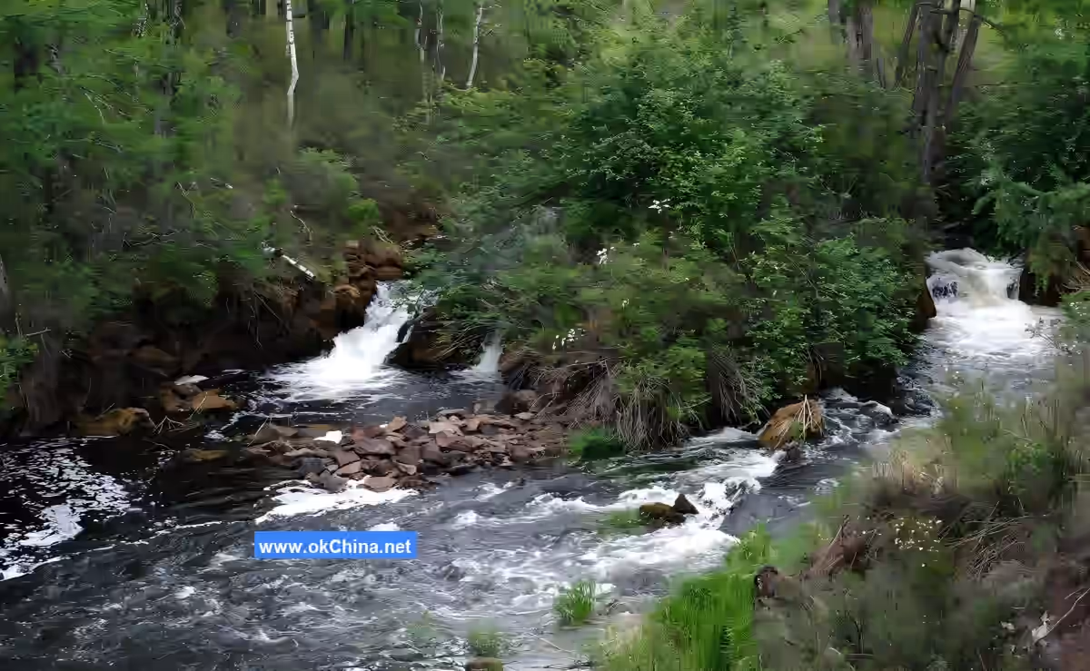
Santan Gorge is located 78 kilometers northeast of Arxan City, in the upper reaches of the Halaha River. The riverbed is composed of rocks of varying sizes, and the turbulent Halaha River flows through the valley, creating a scene of splashing water and swirling currents. Over a 3-kilometer-long gorge, three deep and mirror-like pools—Woniu Pond, Hushi Pond, and Yuexin Pond—are distributed in sequence. Volcanic rocks fill the river valley, allowing people to walk on the stones in the water. The southern wall of the gorge is steep and precipitous, while the northern wall is formed by massive accumulations of volcanic rocks. The banks of the gorge are covered with azaleas. Entering this gorge gives a feeling of a fairyland. Some have praised Santan Gorge with the verse: "Magical and elegant Santan Gorge, clear springs murmur around the cliffs. Where do the splashing pearls and jade go? The soul lingers in the distant Eastern Sea home." This section of the river still has ice and snow in June, earning it the nickname "Summer Glacier."
Halaha River
The Halaha River is the upper source of the Urxun River, serving as a boundary river between China and Mongolia, and belongs to the Erguna River system. It originates from the southeastern mountains of Wudaogou, north of Motian Ridge on the western slope of the Greater Khingan Mountains. Its upper source is formed by the convergence of three streams: Xing'an, Tianchi, and Nangou. After flowing out of Dalbin Lake, it runs from east to west. At the 77-kilometer mark, tributaries Suhu River and Gurban River join it. To the southwest of Yiershi, it further converges with the Arshan River, forming a river 1-1.5 meters deep and 150 meters wide, flowing northwest to a point 14 kilometers west of Shuqiu. At the Sino-Mongolian border, it merges into the Numurgen River, then exits the country, flows through Mongolia, and finally empties into Lake Buir. With a total length of 399 kilometers, 135 kilometers of which flow through Arxan City, it is an excellent location for fishing and rafting.
Haosen Valley Park Scenic Area
Haosen Valley National Forest Park is located within the operational area of Haosen Valley Forest Farm under the Wuchagou Forestry Bureau in Arxan City, Inner Mongolia Autonomous Region. The scenic area spans 24 kilometers from east to west and 22.5 kilometers from north to south, covering a total area of 37,996 hectares. Its geographic coordinates are 120°10′ to 120°45′ east longitude and 47°1′ to 47°20′ north latitude. The scenery varies dramatically across the four seasons, offering breathtaking beauty. Amidst the picturesque mountains and waters, it possesses the three essential elements of modern world tourism trends: sunlight, fresh air, and greenery, making it a forest tourism destination for historical exploration, adventure, and curiosity. The magical, tranquil, and majestic expanse of forest is filled with scenic spots and hidden charm, earning it the reputation of "Little Guilin." The natural landscapes within the scenic area are enchanting, with dense primeval forests, countless perilous cliffs and peculiar rocks, clear pools, and cascading waterfalls hidden among giant trees and exotic flowers, forming a natural landscape painting. "Qilin Peak" stands proudly atop the mountains, gazing into the distance; "Hunter Peak" rises abruptly from the flat forested land, a unique sight; "Tianhe Gorge" is rugged with rocks, deep and serene. Immersed in this environment, with shimmering waters and verdant mountains, gentle breezes, fragrant flowers, birdsong, and vibrant colors, the infinite scenery captivates the heart, making visitors forget themselves and linger with joy.
The park is rich in flora and fauna resources, with 57 families, 190 genera, and 269 species of common ornamental, medicinal, and edible plants. It is also home to a wide variety of wild animals, birds, and fish. Visitors can appreciate the wonders of nature, the wild charm of the forest park, and experience the primitive tranquility of the natural world everywhere. Spring outings for greenery, summer escapes from the heat, autumn admiration of fruits, and winter snow viewing offer year-round enjoyment. All features in Haosen Valley Forest Park are untouched by artificial carving, with natural beauty abundant everywhere, making it an ideal destination for tourism, recuperation, leisure, and vacation.
Qilin Peak
Qilin Peak is the main peak of the Haosen Valley scenic area, named for its shape resembling a qilin (a mythical creature) gazing into the distance. The rock forming Qilin Peak is granite, with a relatively thick base about 15 meters in diameter, tapering upward. The peak is approximately 20 meters high, with a slender neck at the top, formed by long-term physical and chemical weathering of joint-developed granite.
Hunter Peak
Hunter Peak is one of the main attractions in the Haosen Valley scenic area, named for its shape resembling a hunter holding a gun. Separated by Tianhe Gorge, Hunter Peak faces Qilin Peak across the valley. It resembles a hunter wearing a cloak, holding a rifle, lost in thought. It was formed by long-term gravitational collapse and weathering of joint-developed granite.
Immortal Cave
Granite developed two sets of joints in different directions. Under long-term physical and chemical weathering, as well as gravitational forces, the cave continuously collapsed and expanded, forming the present-day cavern. The cave entrance faces 173 degrees and is about 2.5 meters above the ground.
Tianhe Gorge
Tianhe Gorge is a deep valley cutting between two high mountains, with a depth of about 8–15 meters and filled with gravel. It was formed by the convergence and cutting of two watersheds, representing the embryonic form of a river. Influenced by topography and seasons, during the rainy season, water flows down the gorge, forming waterfalls and creating a captivating landscape.
Wuli Spring
Wuli Spring is named for its location five li (approximately 2.5 kilometers) from the mineral spring group of the Arxan Sanatorium. It has a daily flow of 1,054 tons, with water temperature consistently maintained at 3–6°C. The water is rich in 13 essential trace elements and all macroelements for the human body, including metasilicic acid, strontium, and lithium. It has a softening effect on aortic sclerosis and is beneficial for treating heart disease, hypertension, rheumatism, rheumatoid arthritis, and nervous system disorders. Professor Zhang Bowu, a renowned Chinese mineral water expert, praised it as "the world's most extraordinary great spring." General Yang Chengwu acclaimed it as "a miraculous spring in the world, holy water for humanity."
Camel Hump Ridge Tianchi
Camel Hump Ridge Tianchi is a high-altitude lake formed by water accumulation in a volcanic crater after an eruption. The water surface is at an elevation of 1,284 meters, and the lake is shaped like a human left foot, approximately 450 meters wide from east to west and 800 meters long from north to south, covering an area of 26 hectares. This lake is a maar lake, where pumice can be observed. It is a scenic area for sightseeing.
Non-Freezing River
The Non-Freezing River section is 20 kilometers long. Even during severe winters with temperatures below -40°C, this section of the river does not freeze. Green aquatic plants still grow in the water, with mist rising from the river surface and frost-covered trees along the banks, creating a spectacular scene. The non-freezing phenomenon occurs due to the presence of abundant geothermal heat near this river section.
IV. Other Tourism Resources
Mineral Spring Resources
Arxan Mineral Springs are among the world's largest functional mineral springs. According to volcanic research conducted jointly by the Chinese Academy of Sciences and China University of Geosciences, there are over a hundred mineral springs with varying temperatures and functions around Arxan, including cold springs, warm springs, hot springs, and high-temperature springs, suitable for drinking and bathing. Among them, within the national AAAA-level scenic area—the Arxan Hot Spring Sanatorium—48 mineral springs emerge across a 70-meter-wide, 500-meter-long grassy field, capable of treating diseases in eight major systems, including cardiovascular and cerebrovascular diseases, skin conditions, and arthritis. Other mineral springs are concentrated in the Jinjiang Valley and Yinjiang Valley areas. Their medical functions are widely recognized by the medical community. Wuli Spring, located five li from the city center, is a natural high-quality drinking mineral spring rich in essential trace elements and macroelements such as lithium, strontium, and selenium. It has a daily natural flow of 1,054 tons and is praised by mineral water experts as "the world's most extraordinary great spring." According to research by the Chinese Preventive Medicine Association, there are no cases of cardiovascular diseases or cancer among the original residents of the Arxan area.
Ice and Snow Resources
Due to its unique geographical environment, the Arxan–Chaihe scenic area is covered in ice and snow from November to April each year, with mountains and fields blanketed in silver. The area has a long snow season and excellent snow quality, with an average snow depth exceeding 350 millimeters. Combined with its special topography, it is suitable for various skiing activities. In recent years, Arxan City has successively built standard competitive ski resorts (including freestyle, cross-country, and biathlon) and recreational ski resorts. Austrian skiing expert Opitz, who visited for inspection, praised the snow resources here, calling it "the Switzerland of the East." The combination of ice and snow with the city, hot springs, and forests has earned high praise from skiing enthusiasts both domestically and internationally.
Volcanic RelicsIn 2003, the Chinese Academy of Sciences and China University of Geosciences jointly organized a scientific expedition to the Arxan region. It was discovered that the Arxan–Chaihe area boasts over 200 square kilometers of well-preserved volcanic lava landforms, the largest of their kind in Asia. Some of the volcanic lava landscapes here are unique to Asia, featuring rare lava formations not found elsewhere, earning it the title of a "natural volcano museum" from experts. Additionally, four active volcanoes were identified in the Arxan region, making the Arxan volcanic cluster the seventh member of China’s active volcano family. Entering the Arxan–Chaihe scenic area, visitors can admire spectacular sights such as crater lake groups, barrier lakes, and seismic fault zones, allowing them to experience the grandeur and wonder of nature.
Forest and Grassland
Located in the heart of the Greater Khingan Range forest area, this region serves as the convergence point of four major grasslands: the Hulunbuir Grassland, Xilingol Grassland, Horqin Grassland, and Mongolian Grassland. Forest coverage exceeds 64%, and green vegetation coverage reaches 95%. Situated in the cold temperate zone, the area has an average annual temperature of -3.1°C and an annual rainfall of 460 mm. The air here is rich in negative oxygen ions, praised by foreign tourists as "air that could be bottled and exported." It is an ideal destination for summer retreats, leisure, vacations, and recuperation.
Border Trade Port
Arxan borders Mongolia to the west, with only 40 kilometers from the city center to the border. The Arxan–Songbeier Port is the third-largest land port on the China-Mongolia border, following Manzhouli and Erenhot. According to the "Agreement Between the Government of the People’s Republic of China and the Government of Mongolia on Border Ports and Their Management Systems," it has been upgraded to an international seasonal port. It serves as a key hub for the Arxan–Choibalsan Railway, planned by the United Nations Development Programme, and acts as a bridgehead for the fourth Eurasian Land Bridge. On the Chinese side of the port, activities such as border river rafting, fishing, and grassland horse racing are popular tourist attractions. The Mongolian side is a world-class biodiversity nature reserve, rich in flora and fauna, offering opportunities to experience exotic landscapes, unique ethnic cultures, and engage in economic exchanges through border trade.
Ethnic Culture
As early as before the Yuan Dynasty, this region was the starting point for the Mongolian people’s transition from forest to grassland. The Arxan–Chaihe tourist area is a multi-ethnic gathering place, home to the Mongolian ethnic group as well as the three northern minority groups—the Daur, Ewenki, and Oroqen—where ethnic customs are vibrant and deeply rooted. It is also a key national forest industry base, fostering unique forest customs. The region’s hot spring culture, Mongolian-Yuan culture, forest customs culture, and ice-snow culture have a long and profound history.
Comments
Post a Comment